


Where Are the Lowest Points on the Planet?
Where Are the Lowest Points on the Planet?

Just how low can you go on the surface of the Earth? Though most of the planet’s surface is at sea level — which shouldn’t be too surprising when you consider 71% of Earth is covered by water — there are a select few land points that descend to far greater depths. In fact, many of the lowest places on Earth are on the surface of lakes, though they have seasonally fluctuating depths, thanks to intermittent flooding, rainfall, and evaporation. Below, journey down to the 10 lowest points on the planet.
10. Salton Sea – California (-236 Feet)

California’s Salton Sea — a highly saline, shallow body of water in the Colorado Desert at the southern end of the state — was once a thriving resort community in the 1950s and 1960s. For decades, local farmers using water from the nearby Colorado River for agricultural purposes allowed the fertilizer-contaminated runoff to flow back into the lake basin. Since the endorheic lake basin has no drainage flow, this caused a huge rise in the water’s salinity and massive subsequent die-offs of fish and birds, among other wildlife.
As a result, the lake began to emit an odor which drove tourists away; today, many of the beach towns remain abandoned. There’s still a community of artists lingering in the area, though — and the tourism industry is slowly growing again, thanks in part to the nearby cities of Indio and Coachella about 15 miles north of the lake. The latter is home to a massively popular yearly music festival of the same name.
9. Akjagaýa Depression – Turkmenistan (-266 Feet)

The Akjagaýa Depression is located in the Karakum Desert of Turkmenistan, one of the driest areas in the country. The depression is actually contained within Sarykamyska Lake, the waters of which fluctuate in elevation — so much that the lake itself has disappeared and then reappeared several times. The desert is also where you’ll find the Darvaza Gas Crater, also called the “Door to Hell,” a natural gas field that has been perpetually burning since 1971.
8. Badwater Basin – Death Valley, California (-282 Feet)

Death Valley holds the dual distinction of being the hottest place on the planet and one of the lowest. On July 10, 1913, a reading of 134.1 degrees Fahrenheit was taken at the desert’s Furnace Creek Ranch, which is the hottest air temperature ever recorded on Earth.
Extremely hot temperatures aren’t unusual in the world’s very low places, because air warms as it gets lower (and cools as it rises). And very low places are common in this part of California, thanks to the San Andreas Fault running beneath it and periodic water breakthroughs from nearby rivers causing erosion. The lowest point in Badwater Basin is actually within an area of salt flats, but the flats can be treacherous to traverse since they are composed of mud covered by a thin crust of salt. Technically, the sign that marks the lowest point is located a few miles east.
7. Laguna del Carbón – Argentina (-344 Feet)

Located within the Great San Julián Depression (Gran Bajo de San Julián), this salt lake is part of Argentina’s southernmost Patagonia region. The depression ends in high cliffs before it drops off into the Atlantic Ocean, which lies just to the east. The lake’s name translates to “Coal Lake,” and dinosaur fossils have been found in the endorheic basin.
Unlike some other low points in the world, there’s not much tourism centered around the site, which sits on private property and isn’t accessible by public road (although the depression can be viewed from afar from the highway). Mountains loom in the distance, and the small port city of Puerto San Julián is about 30 miles east, but until then, there’s nothing but salt, scrub, and howling winds to be seen in the lake basin and its surroundings.
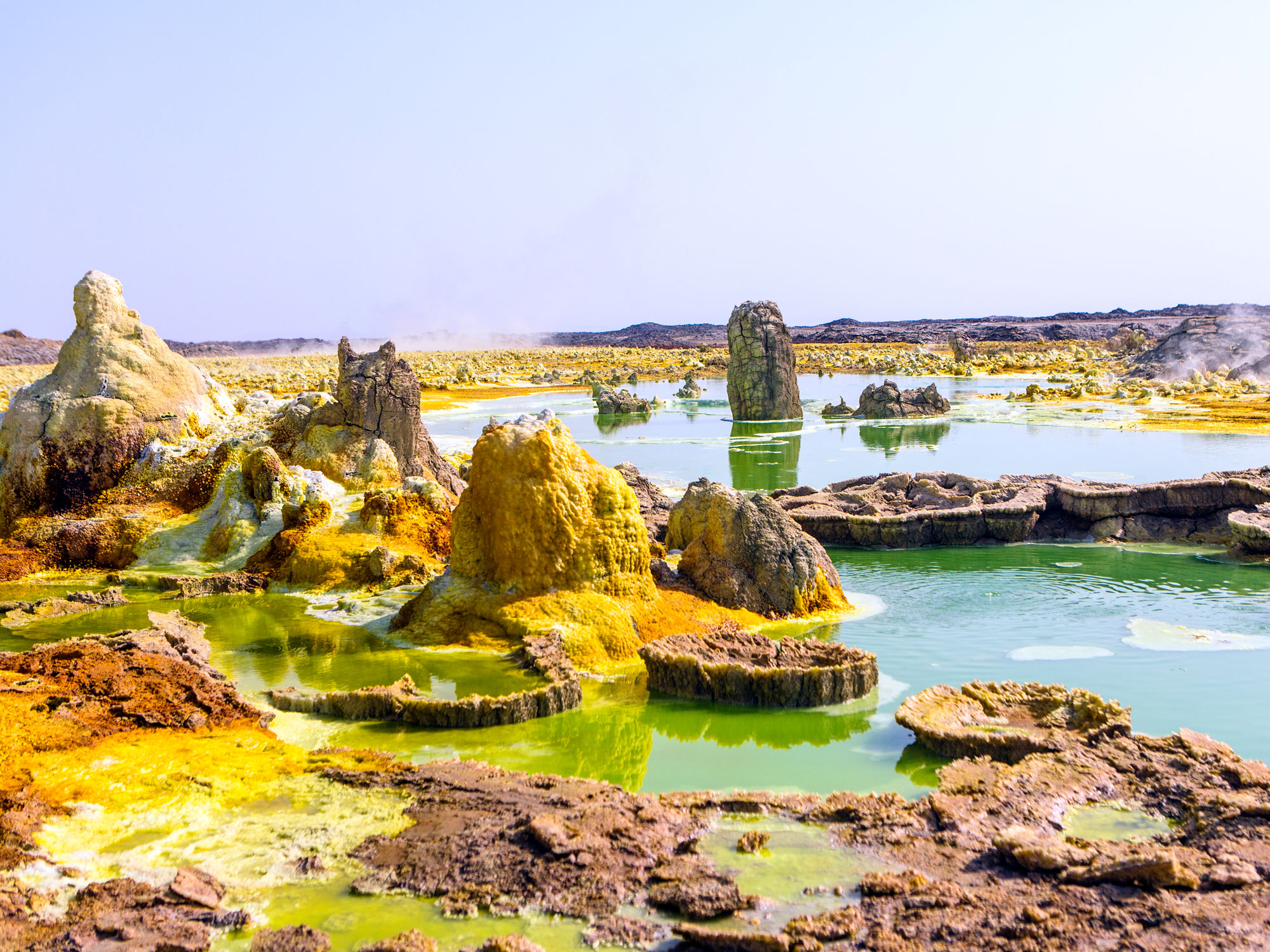
6. Danakil Depression – Ethiopia (-410 Feet)

In northeast Ethiopia is another one of the hottest places on Earth. It’s home to the planet’s sixth-lowest point, located in the Danakil Depression, which sits inside the larger Afar Depression (also called the Afar Triangle). Created by the convergence of three tectonic plates and characterized by active volcanoes, sulfur springs, lava lakes, and toxic gasses in the air, the Danakil Depression contains one of Earth’s most otherworldly landscapes, often compared to the surface of Venus.
Temperatures average in the mid-90s but regularly soar to 120 degrees Fahrenheit. Visitors can take tours on camelback to view the colorful neon-toned landscape of oranges, greens, and yellows, which are caused by oxidized iron and sulfur deposits. The Danakil Depression is also the site where the famous Australopithecus fossil known as Lucy was discovered in 1974.
5. Vpadina Kaundy – Kazakhstan (-433 Feet)

Vpadina Kaundy is located inside a 25-mile-long karst trench called Karagiye, on the Mangyshlak peninsula near the eastern shores of the Caspian Sea. Translating to “Black Mouth” or “Black Jaw” in Turkic, Karagiye was formed when a series of limestone, dolomite, and gypsum caves collapsed. (Vpadina Kaundy is the name for the lowest point within the trench, not the trench itself.)
A seasonal lake lies at the bottom of the trench, as well as a stream originating from a human-drilled well that flows back into a hole in the ground. Karagiye is known for creating its own unusual long rain clouds, which rise above it. Snakes, hares, wild mouflon sheep, and yellow corsac foxes live along the verdant floor inside the trench, while the air above it is home to a population of vultures. Locals also visit the trench to gather mushrooms, the only ones that grow on the Mangyshlak peninsula.
4. Qattara Depression – Egypt (-435 Feet)

At an elevation only two feet lower than Vpadina Kaundy, this 7,500-square-mile sinkhole in northwestern Egypt, near the Mediterranean Sea, is famous for its high cliffs and spectacular black sand dunes. First measured by English geologist Dr. John Ball in 1917, the Qattara Depression is about the size of Lake Ontario, and comprises wild palm and acacia groves, salt marshes, and dry but occasionally flooded lake beds — the latter are characterized by swaths of sticky mud covered by a salt crust. The sinkhole was formed over millennia as salts in the soil slowly eroded the bedrock into sand, which was then blown away by the wind, exposing the water table beneath the bedrock.
Qattara means “dripping” in Arabic, a reference not to the mud or flooded lake beds but a natural spring, Ain El Qattara, one of a handful of natural oases found here. The Qattara Depression is home to fauna such as gazelles, jackals, cheetahs, and wild sheep, as well as cattle, which are bred by nomadic Bedouin ranchers. The depression was also the scene of a crucial defeat against the Axis powers in the First and Second Battles of Al Alamein in 1942. Tanks couldn’t pass through the swamp, so the British Empire’s forces were protected.
3. Ayding Lake – China (-505 Feet)

Ayding Lake is known as Aydingköl in Uyghur, which translates to “moon lake.” It was named for the salt ring around its edge, which gave it the appearance of a shining moon. The lake is the remnant of a 2-million-square-mile inland sea that was formed by the Himalaya Mountains approximately 250 million years ago. Thanks to wells and diversion channels being drilled for irrigation purposes, the lake completely dried up, leaving only mudflats, silt swamps, vegetation, and salt pans today.
Ayding Lake is located in the center of the Turpan Depression, in the Xinjiang Autonomous Region of western China. Desertlike in the northwest and tropical in the southeast, the 20,000-square-mile basin is a fruit-producing agricultural region, particularly known for its grapes and melons, which are irrigated via tunnels that tap groundwater from higher areas. In addition to being China’s lowest point, it’s also China’s hottest place: On July 24, 2015, a new record was set at Ayding Lake when the temperature reached 122.5 degrees Fahrenheit.
2. Lake Assal – Djibouti (-509 Feet)

Lake Assal is also located in the Danakil Desert, a 140-mile drive east of Djibouti. There, you’ll find an inhospitable but beautiful landscape, with pale blue waters and rocky mountains rising in the distance. Look closely, though, and you’ll see that everything that surrounds Lake Assal is encrusted in salt. Due to evaporation from high heat and the lake’s lack of an outflow, the salinity of the water is 10 times higher than that of the ocean. Taking a swim in Lake Assal stings one’s eyes and leaves an oily, salty patina on the skin. In fact, the water’s viscous texture is the reason for its name: Assal means “honey” in Arabic.
The lake and the Danakil Desert are located within the Afar Depression, along with several other extremely low hypersaline lakes, such as Lake Bakili and Lake Afrera. The nomadic Afar people who live in the region use the lake for salt extraction and have established trade routes that lead from the lake through the mountains of Ethiopia. These roads are also used for trading coal and sorghum, among other commodities, all of which are transported by donkey and camel.
1. Dead Sea – Jordan/Israel/West Bank (-1,412 Feet)

In the Jordan Valley, the Dead Sea is situated on the mostly north-south geopolitical border that separates Jordan and Israel, and the West Bank’s southeastern corner also falls within the lake. With shores located at 1,412 feet below sea level, the world’s lowest point blows all other contenders out of the water, so to speak — it’s easily double the depth of the surface of Lake Assal.
Also a hypersaline lake, the Dead Sea is 9.6 times saltier than the ocean. Anyone can easily float in the water as a result of its high salt content. As such, it’s one of the world’s oldest health resorts, patronized even by the biblical Herod the Great, and tourists still flock to its shorelines on all sides. The name “The Dead Sea” never actually appears in the Bible, however. In Hebrew, it was called Yām ha-Melaḥ (the Sea of Salt), and in other texts it was referred to as ha-Yām ha-kadmoni (The Eastern Sea) or Yām ha-‘Ărāvâ (The Sea of the Arabah).
More from our network
Daily Passport is part of Inbox Studio, an email-first media company. *Indicates a third-party property.


