It’s no wonder Canada has a wealth of stunning natural landmarks — the country is home to a quarter of the Earth’s wetlands, temperate rainforests, and boreal forests. The planet’s second-largest country by area, Canada also houses approximately 20% of its fresh water, and even boasts the longest coastline in the world. While most are probably familiar with sites such as Niagara Falls or Banff National Park, there are countless other lesser-known spots to put on your Canadian travel list. From the iconic Hopewell Rocks to the mystical Smoking Hills, here are six must-see natural landmarks of the Great White North.
Hopewell Rocks – New Brunswick

Perched over the picturesque shores of the Bay of Fundy, in the maritime province of New Brunswick, are the colossal rock formations known as the Hopewell Rocks. The awe-inspiring structures were carved by centuries of shifting sands and the relentless force of the world’s highest tides. At low tide, the monolithic rocks can be seen in all their glory — layers of rusty red and earthy brown sedimentary rock reach as high as 70 feet, with the lower, more eroded portions of the rocks narrowing in and the upper reaches expanding outward. The broad shape at the top of the rocks — as well as the evergreen trees that sprout from the top — have also earned the formations the well-known nickname “flowerpot rocks.”
During low tide, visitors can walk on the ocean floor through arches and caves between and around the giant sea stacks. As the tide rises, the rocks become isolated islands, and kayakers can paddle through their narrow channels. More than 100 billion tons of water flow in and out every six hours on the Bay of Fundy, continuing to shape the landscape around it.
Athabasca Sand Dunes – Saskatchewan
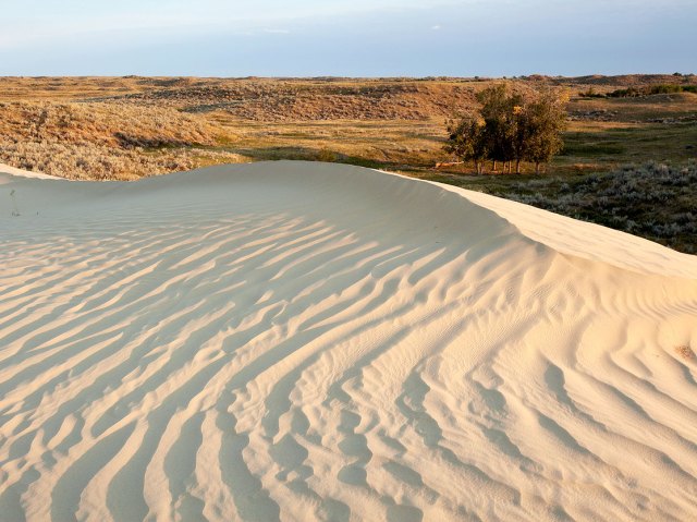
The Athabasca Sand Dunes, located in a remote northern region of Saskatchewan, are the largest sand dunes in Canada and the most northerly dunes in the world. Stretching over 60 miles alongside the southern shores of Lake Athabasca, the dunes reach almost 100 feet in height and stretch for nearly a mile. The dunes are a geological oddity for a province otherwise known for its prairie flats — tucked between a lake and a boreal forest, they’re only accessible by plane or boat. They were formed some 8,000 years ago, when ice from the last glacial period receded. Sand and silt washed into Lake Athabasca, and as water levels dropped over time, the massive deposits were revealed. The Sahara-like dunes were shaped — and continue to be shaped — by strong winds.
The dunes aren’t just a visual spectacle — they also harbor a diverse ecosystem. As many as 70 rare plant species, including at least seven that are only known to exist here, inhabit the area. Although there are no on-site services at the Athabasca Sand Dunes Provincial Park, visitors can embark on guided hiking tours, go fishing, and spend the night camping.
Cathedral Grove – British Columbia
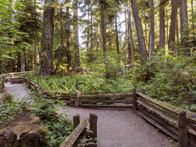
Vancouver, British Columbia, has no shortage of breathtaking old-growth forests, but perhaps no forest is more accessible than the one in Cathedral Grove. Located in MacMillan Provincial Park along Highway 4, between Parksville and Port Alberni, the popular forest teems with towering Douglas firs. Some of the trees are more than 800 years old, have a circumference of almost 30 feet, and soar 200 to 300 feet overhead.
The towering canopy earns the forest its nickname, and though it remains dense, a devastating windstorm in early 1997 changed the park forever. Hundreds of the gigantic trees snapped and were felled; some parts of the Grove’s trail were wiped out and damaged so badly they couldn’t reopen. Devastating as it was, the loss of these landmarks also provided sunlight, shelter, and nutrients for new generations of plant life. To this day, the park’s diversity continues to evolve.
Spotted Lake – British Columbia
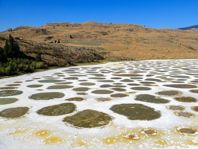
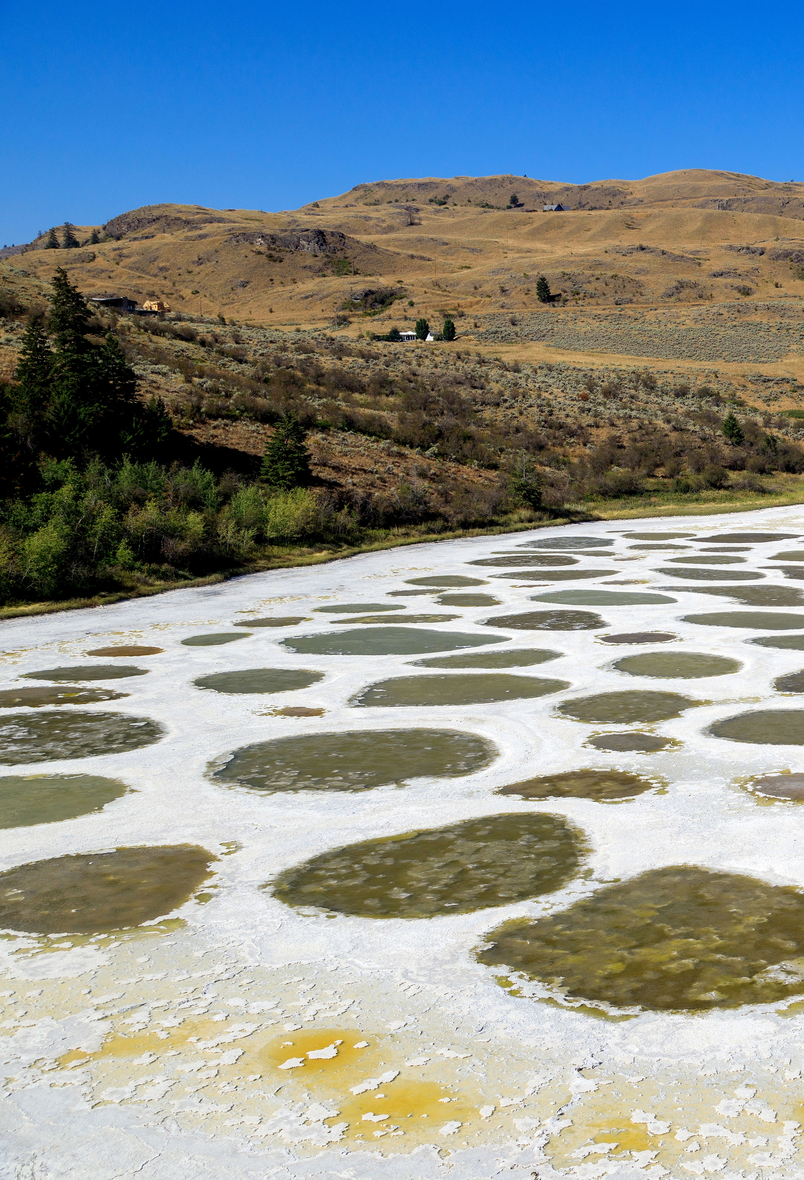
Spotted Lake is a geological wonder located in Osoyoos, the southernmost town in British Columbia’s Okanagan Valley. The lakewater holds a wealth of minerals — including calcium, sodium sulfate, and magnesium sulfate — and as the summer heats up, the lake’s water gradually evaporates. What’s left is a mesmerizing sight: vibrant dots of mineral pools scattered like a mosaic and creating an otherworldly landscape.
The mirage-like effect is more than just a popular sight — it’s considered sacred to the Syilx people, the Indigenous First Nations of the Okanagan region. For centuries, the Syilx have revered this site, utilizing its mud and therapeutic waters for various medicinal and healing purposes. Due to the lake’s cultural and ecological significance, access to the lake itself is restricted. Visitors can instead observe the landscape from the highway or from a designated viewing area.
Sleeping Giant – Ontario
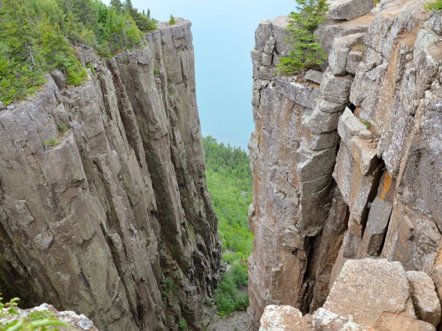
Stretched out in Lake Superior, the Sleeping Giant is a natural rock peninsula that earned its name from its distinct appearance. From the western or northwestern areas of northern Ontario city of Thunder Bay, the shape is most clearly recognizable, with the giant seen lying with its arms gently crossed over its chest. Traveling south towards Squaw Bay, however, the formation starts to shapeshift as it appears to gradually split into smaller sections. Heading further south reveals an intriguing detail: the silhouette of the giant with a visible Adam’s apple.
There are many legends surrounding this Sibley Peninsula landmark. One Ojibway legend identifies the giant as Nanabijou, a powerful spirit who once entrusted the tribe with knowledge of a silver deposit nearby. Nanibijou requested that the mine remain a secret among their tribe; if settlers found out, he would turn himself to stone. Word of the treasures spread, however, and it wasn’t long before a Sioux warrior discovered the coveted mine’s whereabouts. Settlers then also heard word of the mine, but as they approached the peninsula, a storm erupted. With it, a remarkable sight appeared: a stone formation in the shape of a sleeping giant.
Smoking Hills – Northwest Territories
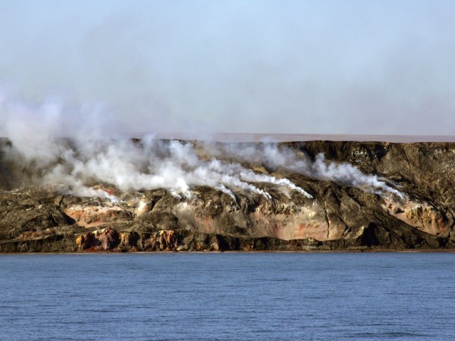
The Smoking Hills are as much a phenomenon as they are a natural landmark. Located where Canada’s Northwest Territories meet the Arctic Ocean, these sedimentary rock deposits have been smoldering for thousands of years, sending billowing clouds of smoke and mist into the air from the red rocky cliffside.
The constant smoke is a result of the landscape: As erosion continues to expose the oil shale rocks, rich in sulfur and coal, the combustible gasses ignite and result in the continuous smoke. Although the hills were already burning when explorer and naturalist John Richardson mapped the area in 1826, Irish explorer Captain Robert McClure is often credited as being the first to record his observations of the enigmatic burning hills, discovered in 1850 while out searching for the doomed Franklin Expedition. Some stories suggest that a sample rock brought back to McClure’s ship burned a hole through his desk. The otherworldly site remains relatively untouched by humans, but researchers have discovered that its mineral makeup is actually similar to that of Mars, and are studying it to learn more about the Red Planet.
More from our network
Daily Passport is part of Inbox Studio, an email-first media company. *Indicates a third-party property.

