7 Geographic Mysteries, Explained
7 Geographic Mysteries, Explained

While we often imagine countries and continents as neatly defined, the world map is full of surprises: unusual borders, shifting time zones, and territorial oddities, to name a few. From cities that belong to one country but exist on another continent to an island that switches nationalities twice a year, here are seven fascinating geographic quirks and the stories behind them.
Why Are There Two Spanish Cities in Africa?

Residents of Morocco can visit Spain without ever crossing the Mediterranean Sea. Two Spanish cities, Ceuta and Melilla, sit along the northern coast of Africa, entirely surrounded by the country of Morocco. Though geographically in Africa, these cities remain politically tied to Spain, a legacy of their time as territories of the Spanish crown. In 1995, Spain granted them official status as autonomous communities.
Ceuta lies just across the Strait of Gibraltar from the British Overseas Territory of Gibraltar (itself surrounded by Spain). A ferry connects Ceuta with the Spanish mainland port of Algeciras. Farther east, Melilla sits on a rocky peninsula called Cabo Tres Forcas. Both seaside towns have a burgeoning tourism industry. Highlights include the 16th-century fortress of Melilla La Vieja and the Royal Wall of Ceuta, a medieval fortification complete with a seawater moat.
Why Is It Tomorrow and Today on the Diomedes Islands?

The Diomedes Islands are located on the U.S.-Russia maritime border. Although they sit just 2.4 miles apart, Big Diomede, a Russian island, is up to 21 hours ahead of Little Diomede, its Alaskan counterpart. That’s because the two islands sit on either side of the international date line. Big Diomede follows the UTC+12 time zone, while Little Diomede operates on UTC-8 or -9, depending on daylight saving time.
Big Diomede remains uninhabited aside from a Russian border guard station, a relic from the Cold War. In contrast, Little Diomede is home to around 80 people, most of whom are Indigenous Iñupiat peoples. Most residents live on the island’s western shore, where they have relied on fishing and hunting for seals, walrus, and seabirds for centuries — though they do receive mail and supplies via helicopter once a week.
Why Won’t Any Countries Claim Bir Tawil?

Bir Tawil, meaning “tall water well” in Egyptian Arabic, is one of the few pieces of unclaimed land left on Earth. This rocky, sandy, and barren patch of desert is nestled between Egypt and Sudan, just east of the Nile River. While it has no permanent population, several thousand people may pass through at any given time — mostly miners and members of regional tribes.
The mainly barren territory became a no-man’s land due to colonial-era border discrepancies. In 1899, Britain set the border so that the nearby Hala’ib Triangle went to Egypt, and Bir Tawil went to Sudan. But in 1902, Britain revised the borders to align with tribal boundaries, flipping the territories and giving Bir Tawil to Egypt and Hala’ib to Sudan. Today, Egypt recognizes the 1899 border, while Sudan claims the 1902 border is accurate, meaning both countries lay disputed claim to the resource-rich Hala’ib Triangle. And neither wants Bir Tawil, which not only lacks any permanent population but also provides no natural resources that would benefit either country’s economy.
Why Does Pheasant Island Swap Nationalities Twice a Year?

The tiny landmass of Pheasant Island switches nationalities twice a year between two European countries. The island is located within the Bidasoa River between Hendaye, France, and Irun, Spain. For half of the year, Pheasant Island is French, and for the other half, it’s Spanish. This unique arrangement makes it the world’s smallest condominium (a place with two rulers).
The joint custody stems from the Treaty of the Pyrenees, signed in 1659, which ended the Franco-Spanish War and granted joint sovereignty of the island to both countries. A commemorative monolith stands at the center of the island, but unfortunately, the island is uninhabited and off-limits to visitors. However, it’s easily visible from either side of the river.
Why Is Egypt Part of Both Africa and Asia?

Egypt is split between two continents. While most of this desert country is located in Africa, a small portion, called the Sinai Peninsula, lies in Asia. The peninsula is separated from the rest of Egypt by the Gulf of Suez and the Suez Canal, which serves as a human-made continental divide between Africa and Asia, completed in 1869.
The vast majority of Egypt’s population lives in Africa, particularly in northern Egypt along the fertile banks of the Nile River. This is also where you’ll find Egypt’s most famous sites, including the Pyramids of Giza, Valley of the Kings, and Abu Simbel.
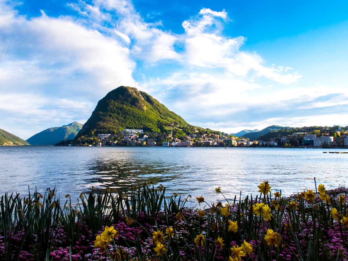
Why Is an Italian Town Surrounded by Switzerland?

At first glance, it might seem like the Italian town of Campione d’Italia accidentally landed in Switzerland. It’s located just northwest of Como, Italy, on the shores of Lake Lugano, which is shared between Italy and Switzerland. The city has a long, complicated relationship with its neighboring country: In 1861, following the unification of Italy, Campione d’Italia remained Italian territory, despite the surrounding area being ceded to Switzerland.
Today, Campione d’Italia offers a mix of Italian and Swiss charm, with lakeside hotels, historic churches, and even a casino. On the outskirts of town, mountain hiking is popular to catch panoramic views of Lake Lugano and the Alps.
Why Is Maine the Closest State to Africa?

You might assume that the closest U.S. state to Africa is Florida, but it’s actually Maine. The confusion arises from the distortion caused by flat maps and the Mercator projection, which has helped navigators plot courses in a straight line since the 16th century. However, because the Earth is a sphere, a flat map greatly distorts the sizes of landmasses, making things appear closer or farther apart than they actually are.
We can pinpoint the location in Maine closest to Africa. It’s called Quoddy Head, and it is about 3,154 miles from El Beddouza, Morocco. This is also the easternmost point of the continental United States. This famous peninsula is known for its historic, red-and-white striped lighthouse and 541-acre state park, where visitors can hike, picnic, and view humpback whales.
More from our network
Daily Passport is part of Inbox Studio, an email-first media company. *Indicates a third-party property.