13 of the World’s Most Unusual International Borders
13 of the World’s Most Unusual International Borders

International borders don’t always criss-cross our planets in neat lines. Due to a variety of historical and geographic reasons, some borders chart a more unusual path. In fact, some border locations are downright bizarre — from a boundary that runs straight through a hotel to a tiny island that changes hands between France and Spain every six months, here are 13 of the world’s most surprising and strangest international borders.
Derby Line, Vermont / Stanstead, Quebec

On one side of the street, you’re in Derby Line, Vermont. On the other side, you’re in Stanstead, Quebec. The border between the U.S. and Canada goes right through these two towns (which basically function as one), straight through businesses and along a main street named Canusa Avenue. In one area, the border is even made up of flower pots. No one knows exactly why the line was drawn through these towns in the early 1700s, though some attribute it to a simple mapmaking error. Nevertheless, Derby Line and Stanstead have chosen to embrace it. The curling hall is in both countries, and so is the library. There is a customs house and border patrol, however, so if you’re out crossing the road, you’ll need to show a passport.
Hotel Arbez, France/Switzerland

Guests at the Hôtel Arbez Franco-Suisse (also known as L’Arbézie) have the unique opportunity to sleep in two countries at once. The hotel sits right on the border between France and Switzerland in the Alpine village of La Cure, 15 miles northwest of Lake Geneva. It was built between 1862 and 1863, when Napoleon III redrew the border between the two countries — right through the land owned by a French citizen named Ponthus Arbez. He decided to build a house on the border before it became official. At first, the French side had a bar and the Swiss side had a store, but when Arbez died, his sons converted the property into a hotel in 1921. Today, guests can cross between the international border in the hotel’s dining room, and some rooms even allow them to sleep with their heads in France and their feet in Switzerland.
Neum Corridor, Bosnia

Though it appears on a map that Bosnia is landlocked, a closer look reveals that the country has a narrow strip of land that extends through Croatia and gives the country just 12 miles of shoreline on the Adriatic Sea. Called the Neum Corridor, the border dates to the 1699 Treaty of Karlowitz, which gave a substantial amount of land around the Croatian city of Dubrovnik to Venice, Italy. Dubrovnik was worried about being so close to Venice and the potential for invasion, so they gave away some of their land to the Ottomans as a buffer — and since Bosnia and Herzegovina were Ottoman-ruled provinces, that’s where the Neum Corridor is today. Aside from Monaco, Bosnia has the shortest coastline of any other country thanks to this stretch of land.
Big Diomede Island, Russia / Little Diomede Island, U.S.

Big Diomede Island and Little Diomede Island, located off the coast of Alaska, are only about 2.5 miles apart in distance, but the time difference between the two is a full 20 hours in winter and 21 in summer due to Daylight Saving Time. That’s because the International Date Line runs right between the islands — along with the border between the United States and Russia (making Russia the closest country to the U.S. without sharing a land border). Big Diomede belongs to Russia, and Little Diomede is in the United States. The islands are nicknamed Yesterday Island and Tomorrow Island thanks to the time difference.
Quadripoint Border of Botswana, Namibia, Zambia, and Zimbabwe

There’s only one spot in the world where four countries come together at one point, and that’s at the intersection of Botswana, Namibia, Zambia, and Zimbabwe in southern Africa. However, the world’s only quadripoint border is located in the middle of the Zambezi River, which feeds Victoria Falls. The river also causes a bit of a debate over the quadripoint: Some say that because the flow of the river has slightly changed, the quadripoint no longer exists and that it’s just two tri-points located close together and separated by a thin strip of land.
Baarle-Nassau, Netherlands / Baarle-Hertog, Belgium

The border between Baarle-Nassau, a town in the southern Netherlands, and Baarle-Hertog, Belgium, is one of the most complicated borders in the world. The border zigzags through the Dutch town and creates a series of Belgian enclaves — parcels of land that belong to Belgium but are completely surrounded by the Netherlands. However, some of those Belgian enclaves themselves contain Dutch enclaves, like a border-based version of Inception. The border goes through homes, businesses, parks, and probably even a couch or two. It’s marked along the ground with a series of white crosses. The peculiar arrangement was a result of medieval land treaties and swaps, when landlines were determined by the aristocrats that lived there. Not sure where the house you’re standing in front of is? Check the location of the front door — whichever country it’s in is the country you’re in.
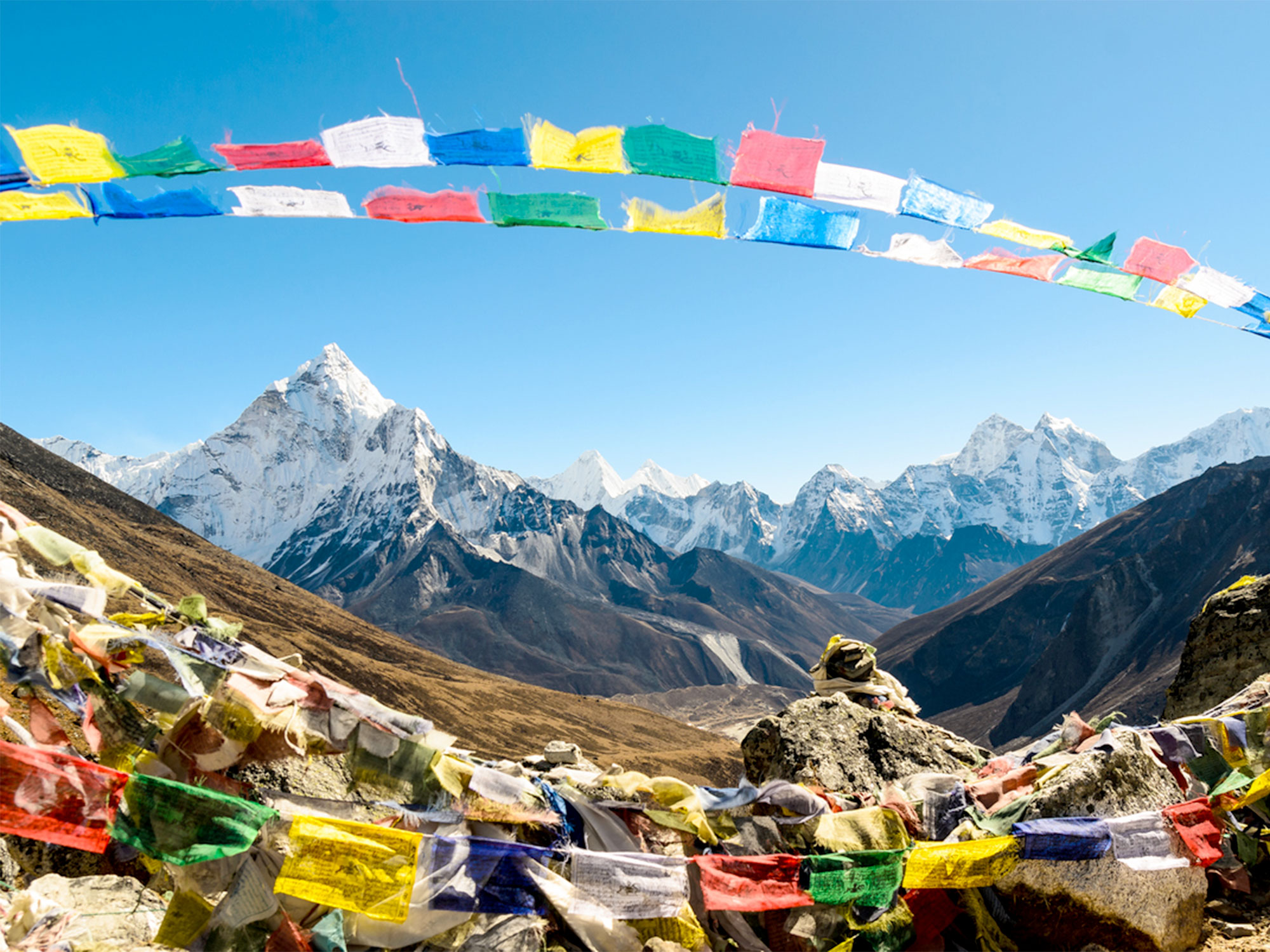
Mount Everest, China/Nepal

Mount Everest is the world’s tallest mountain, and since it straddles the border between China and Nepal, it’s also home to the world’s highest border. The border goes right through the summit, and climbers can scale the mountain from both sides. And in 2020, the world’s most elevated border got even higher. China and Nepal separately took new measurements of the summit and then jointly announced that Mount Everest was even taller than they had originally thought. Now, Mount Everest’s apex is officially 29,032 feet — just about three feet taller than before.
Horodyszcze, Poland / Warez, Ukraine

Between Horodyszcze, Poland, and Warez, Ukraine, there is a giant fish-shaped crop circle. The fish straddles the border between the countries as part of an art project by Polish artist Jaroslaw Koziara. He created them in 2011 for the Land Art Festival, which celebrates the ways art and nature come together. In order to make the massive fish, he used 23 different types of plants. Koziara said his inspiration was to show that borders don’t divide cultures and to celebrate the shared history between the two countries.
Korean Demilitarized Zone (DMZ)

Civilians aren’t allowed in the Korean Demilitarized Zone (DMZ), a 2.5-mile-wide buffer zone between North Korea and South Korea that has been in place since 1953. But wildlife is flourishing in their absence. The border zone stretches for about 155 miles across the Korean Peninsula, surrounded by barbed wire that’s kept people out for more than 65 years, allowing animals to have the run of the place. Of the nearly 5,100 animals and plants documented within the DMZ, 106 are endangered or protected species, including red-crowned and white-naped cranes; musk deer; and Amur gorals. A small area near the border is open to visitors and has been rebranded as the Peace and Life Zone in order to bring awareness to the animal sanctuary there.
Northwest Angle, Minnesota

If you want to visit Northwest Angle in Minnesota, you either have to travel through Canada or take a boat or float plane to get there. The small community of about 120 people is the only part of the contiguous United States that extends north of the 49th parallel. The Angle, as it’s known by locals, borders the Canadian provinces of Manitoba and Ontario and is separated from the rest of Minnesota by the Lake of the Woods. Northwest Angle is the result of a mapmaking error, when early explorers misattributed the source of the Mississippi River. Since the area is so remote, if you want to use the land border to cross into Canada and continue back into Northwest Angle, Minnesota, you have to go into a booth to place a video call to Canadian or American customs officers to pass through.
Mount Athos, Greece

Mount Athos is an autonomous region of Greece populated entirely by men. About 1,400 monks live in the 20 monasteries on the isolated 130-square-mile peninsula in northeast Greece, as they have for more than 1,000 years. Since that time, both women and female animals have not been allowed within its borders. The reason is that women traditionally weren’t allowed in men’s monasteries to ensure celibacy, and unlike other monasteries, the entire peninsula is considered one monastery. Why female animals? According to tradition, the island was once inhabited by the Virgin Mary, and she alone could forever represent her sex — a rule which applied both humans and animals.
Pheasant Island, France/Spain

The border of Pheasant Island, located in the Bidasoa River between southwestern France and northeastern Spain, has changed more than 700 times. There are no permanent residents on the two-acre island and visitors are banned — except for twice a year, when government representatives from each country come together on the island to transfer ownership. The island is considered to be a symbol of peace and neutrality. After the Thirty Years War ended in 1648, France and Spain signed the Treaty of the Pyrenees on the island and made sure it would alternate ownership in perpetuity to demonstrate equality between the two nations. Pheasant Island is what’s known as a condominium, a territory belonging to two separate nations at the same time.
Bir Tawil

With no permanent residents and no one looking to claim it, Bir Tawil is a true no-man’s land — one of the last unclaimed areas on Earth. The trapezoid-shaped, almost entirely barren land is located north of Sudan and south of Egypt. But neither Egypt nor Sudan want to claim the land as their own because of a border technicality. Neighboring Hala’ib is much more valuable land to both countries because it abuts the Red Sea, but when British colonists drew border lines, the agreement stipulated that each country can only have one of the territories and not both. If they claim Bir Tawil, they’ll lose lucrative Hala’ib, which is still disputed between Egypt and Sudan.
More from our network
Daily Passport is part of Inbox Studio, an email-first media company. *Indicates a third-party property.