


15 of the Best Panoramic Views in America
Nothing conveys the grandeur of America’s beauty like a magnificent vista stretching as far as the eye can see. Some panoramic vantage points are created by Mother Nature, while others — such as skyscrapers — have been engineered by humans specifically for postcard-perfect spectacles. Check out 15 of our favorite panoramic views in the United States.
Lookout Mountain – Georgia
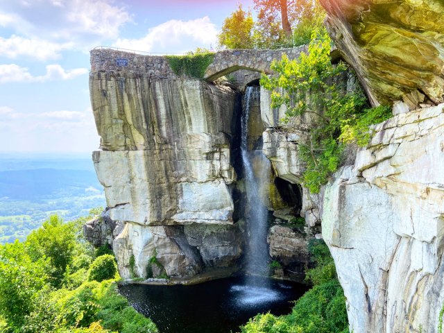
Stand on top of Lookout Mountain on a clear day and you can see, with a little help from binoculars, seven states at once. The summit is in Georgia, and from there you can also see Tennessee (a half mile away), Alabama (25 miles), North Carolina (50 miles), South Carolina (80 miles), and Kentucky and Virginia (about 120 miles).
Lookout Mountain is one of the few places in the United States where so many states are visible at one time, thanks to the mountain’s 2,388-foot summit and the low terrain surrounding it. According to legend, a Civil War nurse was the first to look out from Lookout Mountain, writing, “From this point, on a clear day with a good glass, I think you can see seven states.” Turns out, she was right!
Mount Blue Sky Scenic Byway – Colorado
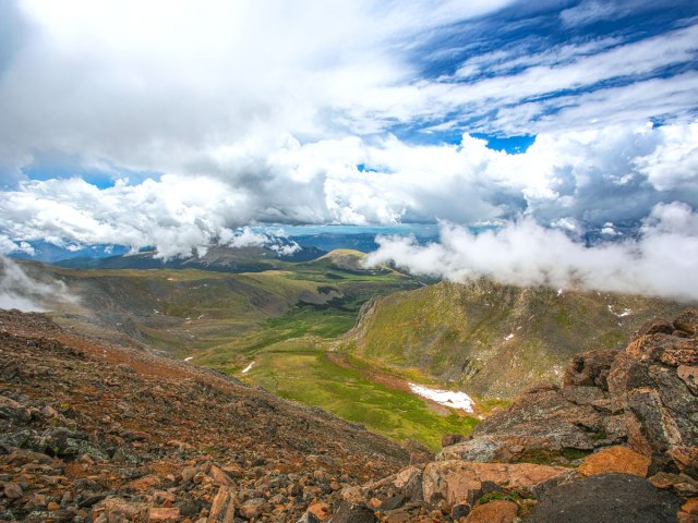
The highest paved road in North America, the Mount Blue Sky Scenic Byway (formerly the Mount Evans Scenic. Byway) is not for the faint of heart. But road warriors who brave the 49-mile trek with plenty of switchbacks will be rewarded with some of the state’s most beautiful scenery and seemingly endless views of the Rocky Mountains. Before summiting the peak of 14,130-foot-tall Mount Evans, visitors can glimpse rare tundra plants and bighorn sheep and mountain goats grazing on the steep terrain. Timed entry reservations for the byway are available.
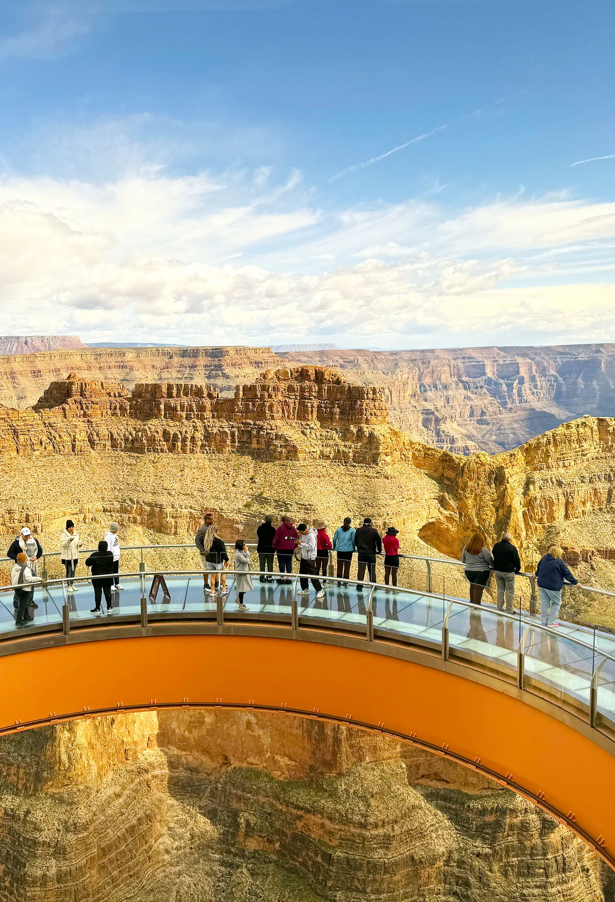
Grand Canyon Skywalk – Arizona
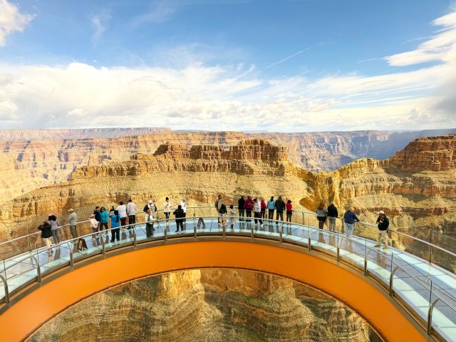
There’s “I’m not afraid of heights,” and then there’s strolling onto a glass walkway jutting out 4,770 feet above the Grand Canyon. The Skywalk is owned by the Native Americans of the Hualapai Nation, and is open to visitors year-round. Those brave enough to walk on the glass path will be rewarded with spectacular views of one of the world’s most famous canyons — and bragging rights to boot. For a less-crowded but equally stunning view, head to the historic Watchtower at Desert View.
Mauna Kea – Hawaii

At 13,803 feet tall, this dormant volcano on Hawaii’s Big Island is the highest point in the Pacific Basin. Estimated to be 1 million years old, it is considered sacred to native Hawaiians. Mauna Kea (“White Mountain”) is also home to Lake Waiau, the only alpine lake in the state, which is capped by snow during parts of the year.
An important location for astronomers, the volcano is home to more than a dozen massive telescopes. Visitors can reach the summit with an approved tour company, but views are also sweeping at the Visitors Information Center, located at 9,200 feet.
D.L. Bliss State Park – California
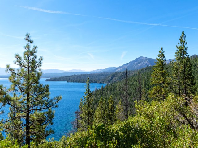
Just two miles north of Emerald Bay State Park (which is also no slouch in the views department), D.L. Bliss State Park offers some of the most stunning vistas of Lake Tahoe, North America’s largest alpine lake and the second-deepest lake in the U.S. Hike to the lighthouse at Rubicon Point — constructed in 1919, it once held the world title for the highest-elevation lighthouse on a navigable body of water. On the shore, fish for trout and salmon and take a refreshing dip at Calawee Cove Beach.
The Skydeck – Chicago, Illinois

There are some things Chicagoans absolutely will not do. Putting ketchup on a hot dog is one, and referring to the city’s tallest building as anything other than “Sears Tower” is another. Whatever you call it, the Skydeck on the 103rd floor of the now-named Willis Tower offers a bird’s-eye view of four states — Illinois, Indiana, Michigan, and Wisconsin — on a clear day. And those brave enough to walk out on the glass-enclosed ledge that extends 4.3 feet from the tower can see straight down to the streets of the Chicago Loop, 103 stories below.
Denali Viewpoint South – Alaska
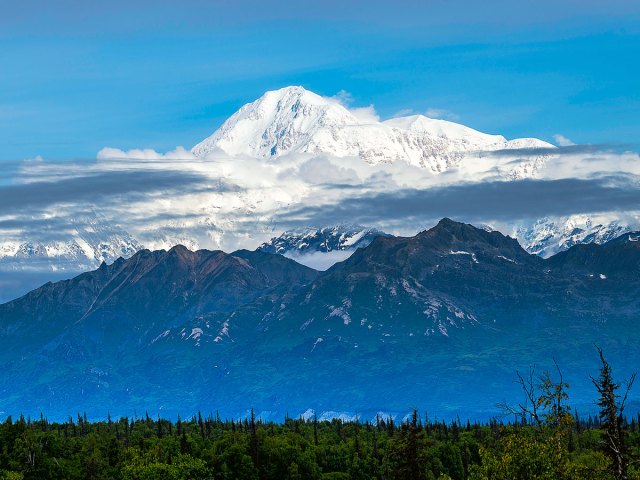
Unless there’s poor visibility due to precipitation, fog, or clouds, there’s no missing the massive mountain of Denali (formerly known as Mount McKinley). At 20,310 feet above sea level, the mountain is the highest peak in North America; it’s the namesake of the 6 million-ace wilderness protected as Denali National Park. Pull off about 40 miles from the mountain on Parks Highway for what may be the best view of its majesty, along with viewing scopes, interpretive boards, and a camping area.
Point State Park – Pittsburgh, Pennsylvania

Covering 36 acres, Point State Park in the Mount Washington neighborhood of Pittsburgh provides an unforgettable panoramic view of the city skyline. Located at the tip of the city’s “Golden Triangle,” the park overlooks the confluence where the Allegheny and the Monongahela rivers join to form the Ohio River.
The area was a strategic battlefield in the struggles between French and British colonists and Native Americans, and history buffs will want to visit the remains of Fort Pitt and Fort Duquesne. Afterward, don’t miss a ride on the Duquesne Incline, one of the few remaining inclines in the country, dating to 1877.
Cadillac Mountain – Maine

Towering 1,529 feet over Maine, Cadillac Mountain on Mount Desert Island in Acadia National Park is the highest point on the Eastern Seaboard. Accessible by car, the peak is the first place to view the sunrise in the United States for much of the year. Delightful at any time of day, it’s nonetheless worth an early wake-up call to see the first rays of dawn illuminate the country.
Gateway Arch – St. Louis, Missouri

A cruise is hands-down the best way to see St. Louis’ famed Gateway Arch and experience the city’s Mississippi River history. Hop aboard the Tom Sawyer, a faithful replica of a 19th-century paddlewheel steamboat, for an unparalleled view of St. Louis from the water. Afterward, take the vertigo-inducing tram up to the top of the Gateway Arch for an insider’s perspective on America’s historic “Gateway to the West.”
Pinnacles Overlook – South Dakota
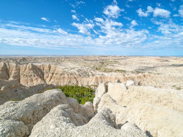
There are many amazing views in South Dakota, but Pinnacles Overlook in Badlands National Park may be among the best. It offers scenic and sweeping views of the rocky outcroppings dotting the Sage Creek Wilderness Area. The overlook is at the highest elevation in the immediate area, and a popular pull-off when touring the Badlands Loop Road, where you can spot bighorn sheep.
Kerry Park – Seattle, Washington

If you’ve seen a photo of the Seattle skyline, odds are that it was taken from this park, named after lumberman Albert Kerry, who donated significant funds toward the property’s purchase. Located in the Queen Anne neighborhood of the Emerald City, Kerry Park provides sweeping views of the skyline, including the Space Needle. On a clear day, you can also admire Mount Rainier and Elliott Bay.
White Domes Road – Nevada

Towering sandstone formations, ancient petroglyphs, and vast desert skies are the hallmarks of Nevada’s Valley of Fire State Park. Even if you aren’t hiking, plan ahead when visiting this 46,000-acre geologic wonderland — plenty of drinking water and a full tank of gas are absolute musts. White Domes Road is perhaps the most picturesque stretch when driving. For a great photo of the road and the surrounding landscape, pull off at Silica Dome Overlook (past the visitors center on the right), and climb up for a panoramic view of the Valley of Fire.
Devils Tower – Wyoming
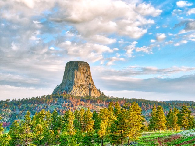
Jutting 1,267 feet above the Belle Fourche River, the igneous rock columns of Devils Tower stretch 867 feet from base to summit, making the tower the largest example of columnar joining on the planet. Home to peregrine falcons and sacred to the Northern Plains tribes, Devils Tower was decreed America’s first national monument in 1906. Movie fans will recognize it as the site of the climactic extraterrestrial scene in Close Encounters of the Third Kind (1977). It’s particularly otherworldly at night, standing tall against a black sky illuminated by the Milky Way.
Seven Mile Bridge – Florida
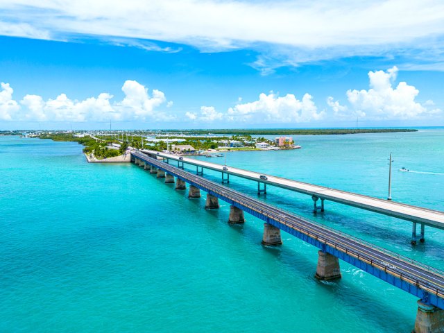
One of the most interesting road trips in the country is along the Overseas Highway (U.S. Route 1), running a little over 100 miles from the southern edge of the Florida Everglades to Key West. In between are 44 islands, 42 bridges, and more fun than can be measured in miles. The entire trip is worth taking (slowly), but one of the best photo opportunities can be found near the city of Marathon on Seven Mile Bridge, a box girder bridge that was once considered one of the longest bridges in the U.S.
More from our network
Daily Passport is part of Inbox Studio, an email-first media company. *Indicates a third-party property.