Top 10 Largest U.S. Cities by Area
Top 10 Largest U.S. Cities by Area
The United States is the world’s third-largest country, covering an area of 3.79 million square miles, and within the 50 states are thousands of towns and cities of varying sizes. While people often talk about a “large” city as one with a significant population, such as New York City or Los Angeles, here we’ll take a look at the 10 biggest cities the U.S. ranked by their total area.
10th Largest U.S. City: Phoenix, Arizona

Area: 517 square miles
Population: 1.66 million (as of 2024)
Sprawling across the northeast Sonoran Desert and surrounded by postcard-perfect mountains, Phoenix ranks as the nation’s No. 10 largest city by land area. Phoenix is also the fifth-biggest city in the U.S. in terms of population, as well as the most populous state capital.
Its earliest inhabitants were the Hohokam peoples, who had a strong presence in the area until around 1450. European settlers established the site that would become Phoenix in the early 1860s. According to legend, pioneer Darrell Duppa chose the city’s name as the new town would be born from the ashes of a former civilization, similar to the legendary phoenix bird.
Popular attractions in Phoenix include the 16,000-acre South Mountain Park and Preserve — one of the country’s largest urban parks — and the Heard Museum of American Indian art. It’s also one of only 13 cities in the country with pro sports teams in the MLB, NBA, and NFL.
9th Largest U.S. City: Oklahoma City, Oklahoma

Area: 607 square miles
Population: 709,000
Oklahoma City bills itself as “the Modern Frontier.” The motto reflects its heritage at the crossroads of the Old West — the city is located almost equidistant from the East and West Coasts — as well as its forward-looking growth.
Though the area was long inhabited by Native American peoples, the foundations for today’s city were established during the Oklahoma Land Run of 1889. On this day, some 10,000 homesteaders came to claim the so-called “Unassigned Lands” — territories formerly inhabited by the Creek and Seminole peoples that were taken by white settlers through the Indian Appropriations Act of 1889.
Today, the Oklahoma capital is the eighth-largest city in the U.S. by area, with a population of nearly 1.3 million. The city was once the only state capital to possess a working oil well on its grounds, which functioned until 2021. Oklahoma City is also famed for hosting more horse shows than anywhere else in the world.
8th Largest U.S. City: Houston, Texas

Area: 665 square miles
Population: 2.32 million
Situated close to Galveston Bay and the Gulf of Mexico, Houston is both the largest city by area and most populous city in Texas, as well as America’s fourth-most populous city after New York, Los Angeles, and Chicago.
Founded in 1836 by land investors Augustus Chapman Allen and John Kirby Allen, Houston is affectionately known as ”the City With No Limits” — it is the only major U.S. city without land-use zoning regulations. This technically means that anything can be built anywhere, although development is governed by ordinance.
Houston is also notable for its cultural diversity: An estimated one in four city residents are foreign-born, and around 145 languages are spoken in the city. Each year, the city also hosts the Houston Livestock Show and Rodeo, the world’s biggest livestock exhibition and rodeo.
7th Largest U.S. City: Butte, Montana

Area: 717 square miles
Population: 36,000
Located in the southwestern corner of Montana is the historical mining city of Butte (officially named Butte-Silver Bow). Settled in the late 1800s, the country’s seventh-largest city takes its name from a peak called Big Butte.
The settlement grew quickly as it attracted gold and silver prospectors to what would become known as “the Richest Hill on Earth.” Mining interests later turned to copper, and by 1900 the city was responsible for about half the nation’s copper production. In 1977, the city merged with the county of Silver Bow to form one consolidated city spread over 700 square miles.
While the mining trade is now a thing of the past, the legacy lives on through landmarks such as the Headframes (14 towering steel structures built on top of former mines), the 7,000-foot-long Berkeley Pit (a former copper mine), and the World Museum of Mining.
6th Largest U.S. City: Anaconda, Montana

Area: 736 square miles
Population: 9,800
Located 25 miles west of Butte, Anaconda is another vast city that played a significant part in Montana’s copper mining history. Once populated by the Shoshone and Salish tribes, the city was founded in 1883 following the discovery of massive copper deposits. White settlers soon arrived en masse to find their fortune working at the Anaconda Copper Mining Company.
Some buildings, such as the Washoe Theater and 585-foot-tall Anaconda Smelter Stack, still remain from the city’s mining heyday. Straddling the Continental Divide, the city also attracts outdoor adventurers, notably to the 158,000-acre Anaconda-Pintler Wilderness.
5th Largest U.S. City: Jacksonville, Florida

Area: 840 square miles
Population: 997,000
Set on the northeastern coast of Florida, Jacksonville is the largest city by area in the contiguous United States. With the city’s water territory included, it covers over a whopping 840 square miles — about four times the size of the island of Manhattan in New York City.
Jacksonville was named in 1822 for the country’s seventh President Andrew Jackson, who was the governor of the Florida territory at the time — although he never actually visited the city in his lifetime.
Today, Jacksonville has the nation’s largest urban park system, which occupies 80,000 acres — made up of two national park sites, seven state parks, and 400 city parks. It also boasts Florida’s longest city coastline at 1,100 miles, including 22 miles of beaches.
4th Largest U.S. City: Anchorage, Alaska

Area: 1,705 square miles
Population: 284,000
Covering more than 665,000 square miles, Alaska is by far the nation’s largest state by area, so it’s perhaps of little surprise that the state is home to four of the top 10 largest cities in the U.S. by area. Anchorage is Alaska’s largest city by population (home to 288,000 people) and has a land area larger than the state of Rhode Island.
The area’s first inhabitants were the Dena’ina peoples, a tribe of Athabascan Native Americans. Captain James Cook explored the region in 1778, and in 1835 a Russian mission was established in the area. Following the discovery of gold nearby, the city quickly grew and was officially founded in 1914 as the headquarters of the Alaska Railroad.
Today, Anchorage is home to about 40% of the state’s population. The city is notable for its natural surroundings — on clear days, it is possible to see six mountain ranges and Denali, the highest peak in the country.
3rd Largest U.S. City: Wrangell, Alaska

Area: 2,546 square miles
Population: 2,000
Wrangell sprawls across the northwest corner of Wrangell Island in southern Alaska. It’s one of three cities in the state that are larger than both Rhode Island and Delaware, though the city is home to just 2,500 residents.
Wrangell has been the home of Tlingit people for thousands of years. Their culture and legacy is celebrated at places like Chief Shakes Island and Petroglyph Beach State Historic Site. The first European settlement was established by Russian traders in 1834; however the fort was later abandoned and taken over by the British until the United States’ 1867 purchase of the Alaska territory. This history is showcased at the Wrangell Museum.
Today, the city is also a popular gateway for fishing, hiking and bear-spotting adventures in the nearby Tongass National Forest, the country’s largest national forest at 16.7 million acres.
2nd Largest U.S. City: Juneau, Alaska

Area: 2,702 square miles
Population: 31,300
Though Juneau is Alaska’s second-largest city, it is the largest state capital in the United States by area. Located along the Gastineau Channel, Juneau was established in 1880 when prospectors Richard Harris and Joe Juneau discovered gold. Prior to this, the area was known by Indigenous peoples as the Dzantik’i Héeni (“Base of the Flounder’s River”), and was a favorite fishing site.
Today, Juneau is a thriving hub for the arts, food, shopping, and outdoor pursuits. The city is located 13 miles from the 13-mile-long Mendenhall Glacier, the area’s only glacier that is accessible by road year-round. Visitors can also go whale watching, explore over 250 miles of hiking trails, and ski on Douglas Island.
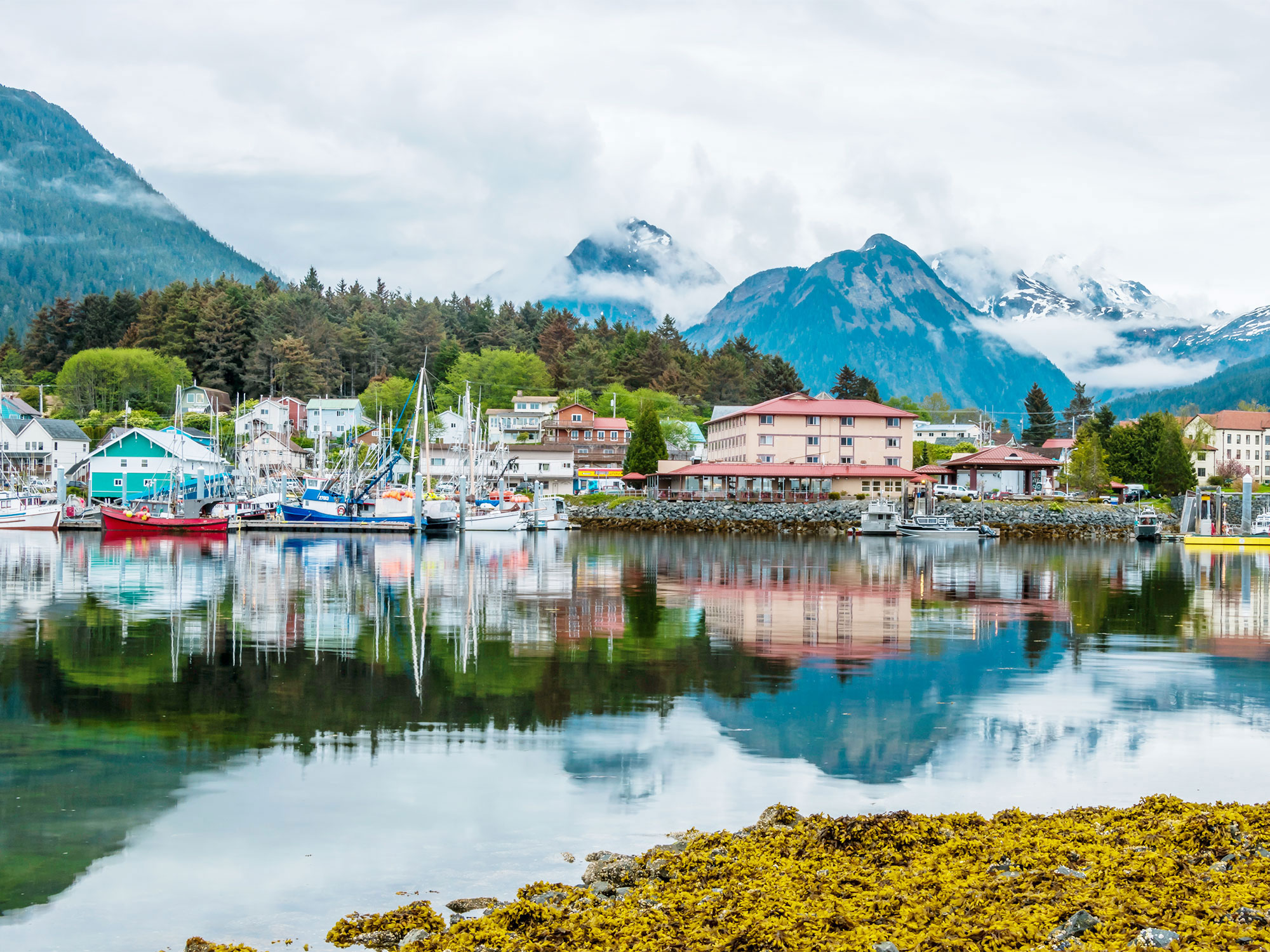
Largest City in the U.S.: Sitka, Alaska

Area: 2,870 square miles
Population: 8,200
Sitka spreads across Baranof Island in the Alaska Panhandle, with Mount Edgecumbe across the Sitka Sound to the west. The city showcases a unique blend of Tlingit heritage and Russian history. Originally known as Sheet’Ká, it was called New Archangel during the Russian occupation beginning in 1799.
In 1867, the Russians handed over possession of the Alaska territory to the U.S., but reminders of its former rulers are visible throughout the city, such as at the Russian Bishop’s House. Like many Alaskan cities, today it is a popular hub for nature enthusiasts, with myriad opportunities for spotting wildlife on hiking, kayaking and seaplane excursions.
More from our network
Daily Passport is part of Inbox Studio, an email-first media company. *Indicates a third-party property.