


20 Places on Earth That Shouldn’t Exist (But Do)
20 Places on Earth That Shouldn’t Exist (But Do)

From bubblegum pink lakes to rainbow-hued hot springs and glowing neon blue bays, there are many places on Earth that look like they might belong on another planet. While the photos below might look more like a CGI movie backdrop or surreal works of art, the places depicted in these breathtaking images are actual places you can visit. Don’t believe us? Take a look for yourself at these 20 photos of places on Earth that don’t look real.
Lake Hillier – Australia

You might do a double take when you first see this lake, which looks more like a puddle of bubblegum ice cream than an actual body of water. The stunningly pink Lake Hillier sits on Middle Island, part of a nationally protected reserve on an archipelago off the coast of Western Australia. Its color is likely a result of micro-algaes, such as Dunaliella salina, that thrive in the lake’s salty water. These microorganisms produce beta-carotene, a pigment found in carrots, which is believed to be the cause of the lake’s unforgettably pink hue.
Grand Prismatic Spring – Wyoming

The Grand Prismatic Spring adds a splash of tie-dye color to the beauty of Yellowstone National Park. It’s the third-largest spring in the world and also the most photographed thermal sight in Yellowstone.
The varying bands of color around the spring result from the presence of thermophilic, or heat-loving, bacteria. Hot water moves from the center of the Earth’s crust to the surface of the spring. It cools at the edges of the spring, and the bacteria there create the rainbow of colors that draws thousands of visitors each year.
Fjaðrárgljúfur – Iceland

We’ll forgive you if you can’t pronounce this canyon’s name, because the view alone will probably leave you speechless. Fjaðrárgljúfur formed about 9,000 years ago and remained a hidden gem until Justin Bieber filmed a music video there in 2015, bringing this magnificent spot to the world’s attention.
After being flooded with an influx of visitors in the following years, the Environmental Agency of Iceland temporarily closed the canyon in 2019. The country is now focused on reducing the effects of climate change and building the necessary infrastructure to support year-round visitors. Once it’s open to the public again, you can marvel at the 300-foot-high canyon walls that wind like a serpentine through the southern part of the island.
Socotra – Yemen

This isolated, four-island archipelago in the Indian Ocean is home to a variety of plants and animals you won’t find anywhere else on Earth, which is how it earned its place on the UNESCO World Heritage list. Approximately 37% of Socotra’s plants (including the superbly named dragon’s blood tree, pictured here), 90% of its reptiles, and a whopping 95% of its land snails are endemic to the archipelago.
Despite its remote location, Socotra is home to about 50,000 human residents, too. Many of them fish, dive for pearls, and raise crops and animals. The island’s famous exports include frankincense, fish, and ghee.
Salar de Uyuni – Bolivia

Stretching more than 4,000 square miles across the Andes of Southwestern Bolivia, the Uyuni Salt Flat contains an estimated 10 billion tons of salt. Within the layers of salt lies 70% of the world’s lithium reserves, making this area particularly important for the manufacturing industry, as lithium is used to make batteries for laptops, cellphones, and electric cars.
For travelers, however, the area’s appeal lies in the unique hexagonal formations on the surface, as well as the mirroring effect that’s created when a thin layer of water covers the salt flat on a sunny day. Though local legends have different takes on how the area came to be, scientists tell us that the salt flat formed over 40,000 years ago, when an evaporated lake left behind a thick crust of salt.
Fly Geyser – Nevada

The Fly Geyser consists of three strange misshapen mounds of Earth rising from the northern Nevada desert. But these mounds are actually the result of human actions, rather than nature.
The first geyser formed here in 1916 when residents in the area dug a well, only to discover that, at 200 degrees Fahrenheit, the water was too warm to be useful. About five decades later, a geothermal power company drilled a test well on the site. Because the well had been improperly sealed, hot water spewed forth. Over time, mineral deposits formed and eventually grew into the multicolored green and red cones we see today.
Notably, the insides of the cones contain quartz, which typically doesn’t start forming inside geysers until at least 10,000 years have passed, making these geysers even more unusual than they appear.
Naica Mine – Mexico

In Mexico, the Cave of the Crystals within Naica Mine looks like a supersized salt shaker you can climb right into. This cave is home to the largest crystals in the world, which were remarkably discovered only 20 years ago.
The conditions inside the cave are ideal for growing crystals since the air is acidic, humidity is high, and no natural light enters. As a result, the crystals inside the cave have reached lengths of up to 36 feet. The largest crystal is believed to have been growing for approximately 500 years. Unsurprisingly, the ideal conditions for growing crystals aren’t so ideal for humans, so you can’t enter the cave without wearing a special suit.
Richat Structure – Mauritania

Unlike other sites on this list, this structure doesn’t offer much to see at ground level. In fact, you may even have trouble finding it, despite its 28-mile diameter. From space, however, this formation looks like a giant bullseye or a landing site for flying saucers, which has earned it the “Eye of the Sahara” nickname. Its unique appearance has long captured the imagination of astronauts, but alas, the geological feature does have origins here on Earth.
The Richat Structure consists of what geologists call a domed anticline that has been eroded by the elements over 100 million years, revealing layers of older igneous and sedimentary rocks surrounded by newly formed rocks.
Tunnel of Love – Ukraine

An industrial train track wouldn’t normally make a list of incredible places to visit, but the Tunnel of Love is a notable exception. Just outside of Klevan, Ukraine, this two-mile tunnel is formed from trees growing over the tracks, their branches and leaves creating a brilliant green canopy overhead.
The tunnel dates back to the Cold War, when trees were planted around the tracks to hide the transporting of war materials to and from a nearby military base. Since then, the Tunnel of Love has undergone quite the rebranding. Today, it’s believed that couples who make sincere wishes during their visit will see their hopes and dreams come true.
Mosquito Bay – Puerto Rico

Mosquito Bay is the world’s brightest bioluminescent bay, located off the island of Vieques. The bay gets its dazzling neon blue color from microscopic organisms in the water that capture light energy from the sun and glow when agitated or touched.
Though these microorganisms live in the ocean, you can only find them in a few rare spots on Earth, which makes Mosquito Bay even more special. Their large concentration produces a visible glow-in-the-dark effect in the bay’s waters. For a truly otherworldly experience, visit during a new moon, when the dark night sky will further illuminate their glow.
Zhangye National Geopark – China

Also known as the Rainbow Mountains, these colorful peaks offer one of the most surreal sights in the world. Known as a Danxia landform, meaning “red cloud,” the site covers approximately 19 square miles in China’s Gansu province and has become a popular UNESCO World Heritage Site.
The colorful stripes are reflective of how the mountains formed. The land was once flat, containing layers of different minerals. When the tectonic plates collided millions of years ago, the land was pushed up and the various layers were revealed — creating an array of colors that attract visitors from all over the world.
Mendenhall Ice Caves – Alaska

For those willing to brave bone-chilling temperatures, the tunnels of blue ice formations in the Mendenhall Ice Caves are a worthy payoff. Located about 12 miles outside of Juneau, Alaska, the Mendenhall Glacier stretches another 12 miles into the Mendenhall Valley, and its partially hollow interior allows for easy exploration.
Unfortunately, climate change has had a negative impact on the glacier, causing it to recede nearly two miles over the last 60 years. If the ice melts and the caves continue to shift, they may eventually become inaccessible to humans. But for now, the stunning blue hues of the ice caves leave an indelible mark on anyone who makes the trek inside.
Tulip Fields – The Netherlands

With rows of blooms in vibrant colors, the seasonal tulip fields in the Netherlands look like a postcard come to life. Here, the flowering season begins in March, with crocuses and tulips in full bloom from mid-April through the first week of May. Though there are a number of fields across the country, the largest and most famous are at Keukenhof.
Every autumn, more than seven million bulbs are planted, turning the area into an enormous patchwork quilt of kaleidoscopic colors. Keukenhof is located just 25 miles southwest of Amsterdam — which makes it a convenient destination for your springtime travels.
Antelope Canyon – Arizona

The smooth red sandstone slopes of the canyon consist of multihued striations, artfully sculpted by wind and water over 190 million years. Located in Arizona on Navajo land, this famous slot canyon is divided into Upper Antelope Canyon and Lower Antelope Canyon, both of which can be accessed only by guided tours.
The upper canyon is particularly popular with tourists. There, visitors can see shifts of cascading sunlight grazing the 120-foot rock walls, creating incredible photo ops that make it one of the most photographed places in the Southwest. The hike through the lower canyon is more physically demanding but offers equally memorable scenery.
Dead Vlei – Namibia

Located on the western edge of Namibia, the landscape at Dead Vlei looks like a surrealist painting, with its starkly contrasting red-orange sand dunes set behind apocalyptic trees and the dried white clay pan of the desert floor..
The trees began to grow when the area was flooded by a nearby river. In later centuries, however, newly formed sand dunes cut off the water supply. Though the trees here are around 900 years old, they haven’t yet decomposed due to the extreme dryness of the climate — leaving them intact in all their bleak, barren beauty.
Stone Forest – China

While touring China, you won’t want to miss Shilin, also known as the Stone Forest. Its towering karst landforms have earned it a place on the UNESCO World Heritage list. The landscape began forming 270 million years ago and today covers approximately 150 square miles in the Yunnan Province. In addition to the labyrinth of limestone towers and ridges, the Stone Forest is home to caves, lakes, waterfalls, and even an underground river.
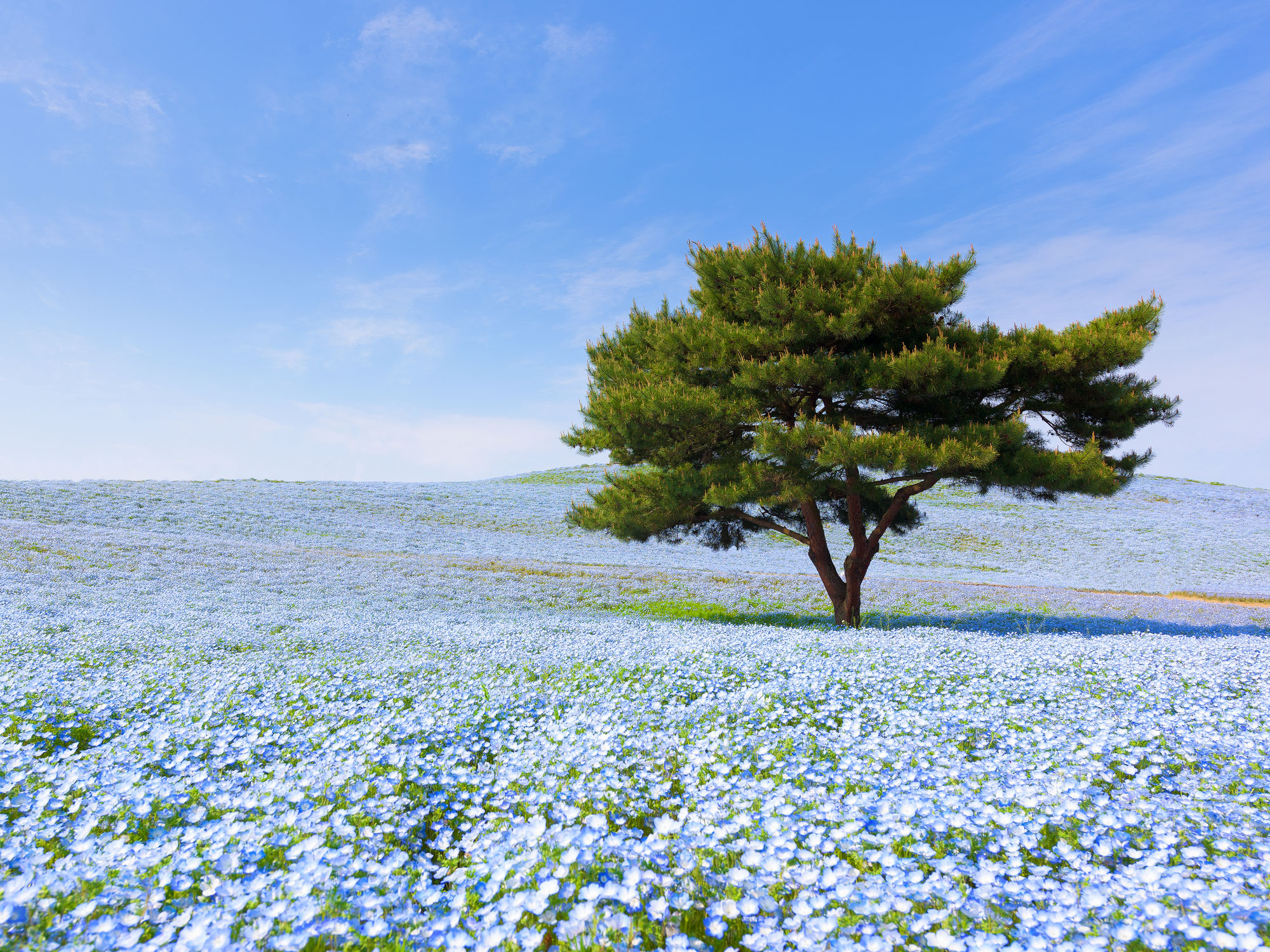
Hitachi Seaside Park – Japan

The beautiful trails of Japan’s Hitachi Seaside Park wind through flower beds lined with millions of daffodils, tulips, roses, red Kochia, and baby-blue Nemophila that seem to stretch as far as the eye can see. Flowers bloom in every season, making it a popular year-round attraction which you can explore on foot or bike.
There’s also an amusement park on site, complete with a Ferris wheel and roller coaster, so you can enjoy a little adrenaline rush after admiring the flowers.
Bergpark Wilhelmshöhe – Germany

Combining ornate Baroque architecture with waterfalls and overgrown gardens, Bergpark Wilhelmshöhe evokes thoughts of a fairytale castle. Europe’s largest hillside park offers a mix of unexpected sights, from a Chinese pagoda to a towering statue of Zeus.
The park is located in the city of Kassel in central Germany. Its construction began in 1696; over the following centuries, various features such as gardens and fountain displays were added to the park.
The Gates of Hell – Turkmenistan

The Darvaza gas crater has been burning in a Turkmenistan desert for about five decades, earning it the nickname of “The Gates of Hell” or “The Door to Hell.” Approximately 226 feet in diameter and 98 feet deep, the pit is located in a natural gas field. This gives it all the fuel it needs to light up the desert like the world’s biggest campfire.
According to most accounts, the crater was first discovered in 1971, when geologists thought they had found an oilfield. Instead they were drilling on top of a large pocket of natural gas, which collapsed under the weight of their equipment. Since the high quantity of methane in natural gas can make it hard to breathe, the scientists set the pit on fire in order to protect the area’s wildlife. They hoped to burn off the gas in a few short weeks, but their plan failed. Since it’s difficult to tell exactly how much gas there’s left to burn, the Gates of Hell could stay open for a while.
Carlsbad Caverns – New Mexico

The stalactites and stalagmites, underground pools, and rippled limestone walls give the 100 caves that make up the Carlsbad Caverns an otherworldly appearance.
One of the oldest cave systems in the world, estimated to have formed 3.9 million years ago, the caverns are also biologically diverse ecosystems with bat colonies and other habitats. Each of the various chambers — such as the Temple of the Sun, the Big Room, and the Hall of the Giants — has unique geological features that were formed over centuries.
More from our network
Daily Passport is part of Inbox Studio, an email-first media company. *Indicates a third-party property.


