


7 Stunning Aerial Photos of the World’s Most Famous Landmarks
7 Stunning Aerial Photos of the World’s Most Famous Landmarks


Travelers typically take in famous landmarks from the ground, standing below them at a designated viewpoint. But there are other ways to see these renowned places from alternate angles on the ground, or even from up above. These rarely seen perspectives allow once-familiar landmarks to show off unexpected shapes and intricate details that can be easy to miss at eye level. Here are seven aerial photos that show some of the world’s most famous sites in a way few people get to experience.
Mont-Saint-Michel – France
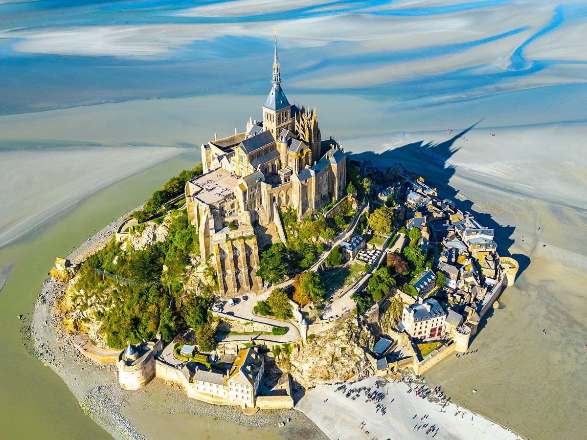
Mont-Saint-Michel already feels surreal at ground level, but from above, the full scope of its majesty becomes clear. The historic abbey — once a monastery and, until 1863, a state prison — sits atop a tidal island of the same name, while the village descends below in dense, crescent-shaped layers. The overhead view highlights just how compact the island is, with seemingly every inch of space efficiently used.
When the tide between the French regions of Normandy and Brittany is out, the scale of the island’s fortified walls becomes much clearer. Ethereal tidal patterns form ripples around the rock, emphasizing the settlement’s close ties to its environment. To see it from this angle for yourself, you can book a tour on a private ultralight aircraft.
Ha Long Bay – Vietnam
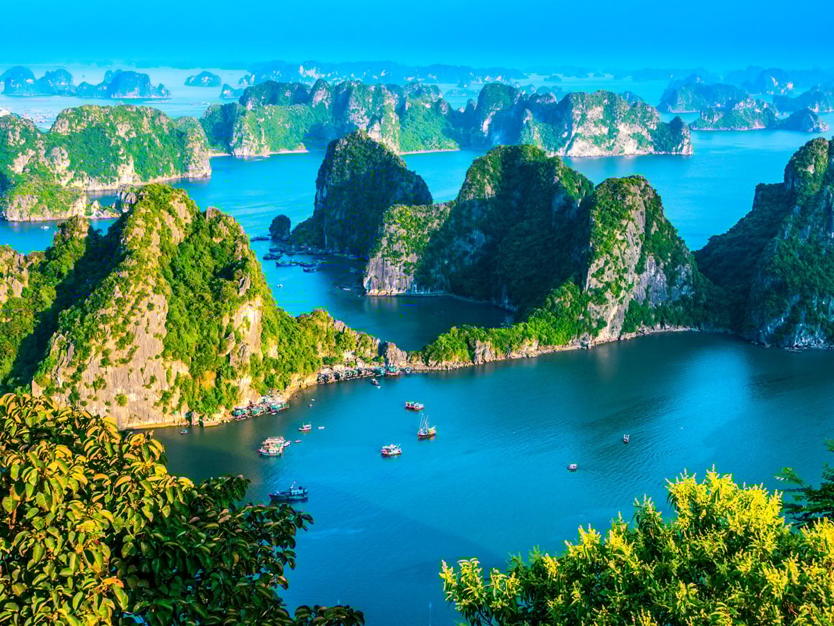
As stunning as this natural wonder is, it isn’t easy to take in Ha Long Bay all at once. At water level, the bay’s towering limestone pillars feel endless, but from above, the scale of the 1,600 or so jagged rock formations becomes much clearer — and even more striking. Spanning roughly 600 square miles in Vietnam’s Gulf of Tonkin, the bay looks quite dense from overhead: a scatter of massive karsts covered in dense vegetation and pierced by narrow emerald channels, rocky cutouts, and covered coves.
These corridors have supported fishing communities for generations, and today, their natural beauty draws around 2.6 million visitors a year. From overhead, shifting water colors at different depths also help us see how erosion and tides carved the landscape over millions of years. Seeing it this way on a seaplane tour reveals how complex the marine environment truly is.
Palmanova – Italy
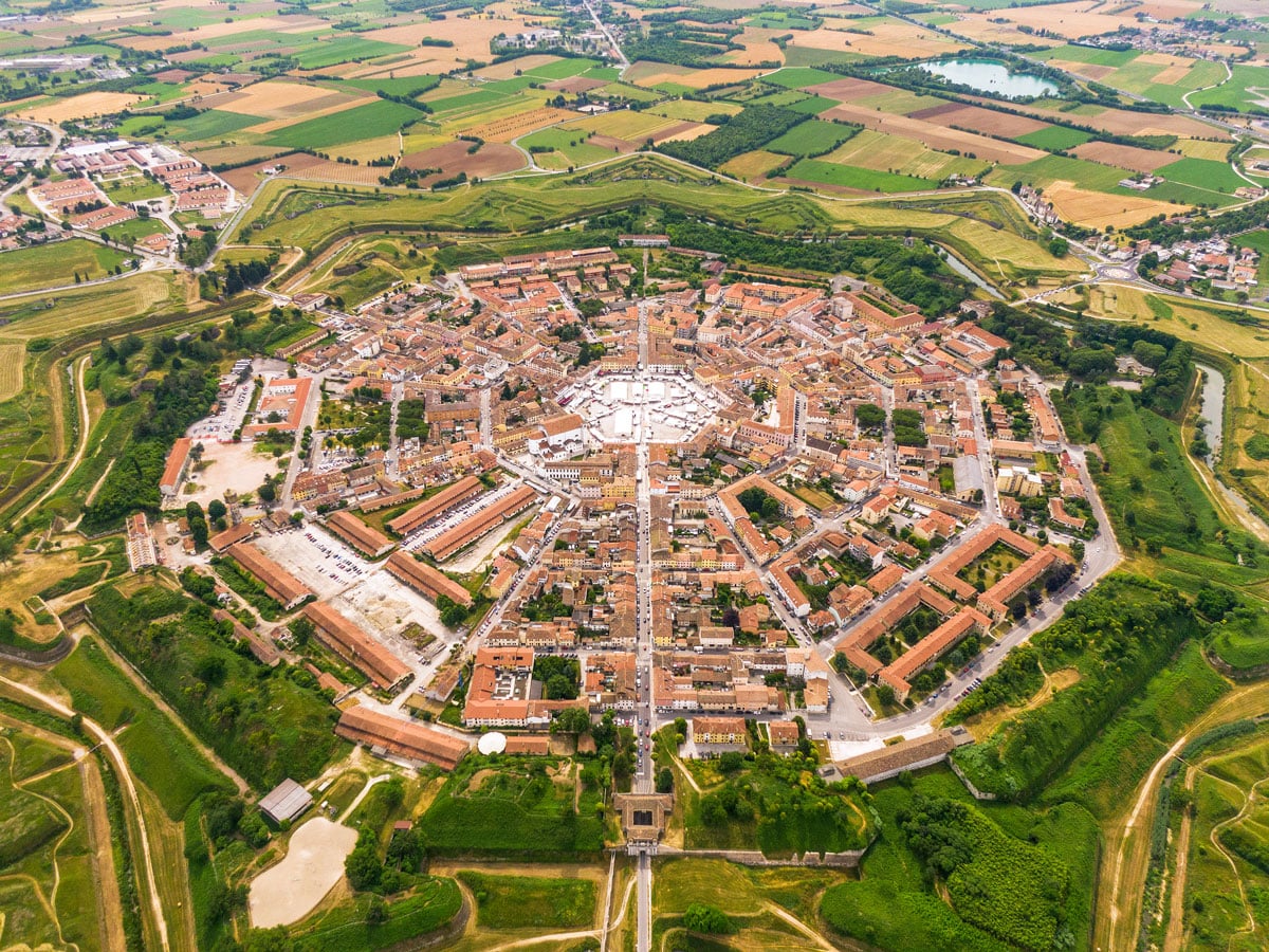
Seen from above, Palmanova is immediately eye-catching. The village forms a perfectly symmetrical nine-point star, with concentric streets converging at a public square in the center. Built in 1593 by the Republic of Venice, Palmanova was primarily meant to serve as a fortress, and its star shape was deliberate to defend against the Ottoman Empire.
But Palmanova was also intended as a utopian model town. This popular Renaissance idea emphasized harmony, and the town was built with zones for both troops and civilians, arranged for strategic and functional purposes. The city’s clear geometric patterns are easily decoded from above — in fact, the design is so precise that Palmanova is even visible from space.
The Pentagon – Virginia

At street level, the Pentagon mostly feels like a massive building. But the structure, which serves as the headquarters for the U.S. Department of Defense, has a geometric precision that can best be seen when flying in and out of nearby Ronald Reagan Washington National Airport.
The five-sided shape was originally chosen to fit a differently shaped plot of land, but architects kept it for efficiency. They felt it allowed easier access across the vast complex while limiting its height (so as not to obscure views of the Potomac) and its use of steel, a valuable resource during World War II. The governmental symbol may have one of the most recognizable building footprints in the world, but its bare, stripped classicism architectural style and its massive scale help it retain an air of mystery.
Angkor Wat – Cambodia
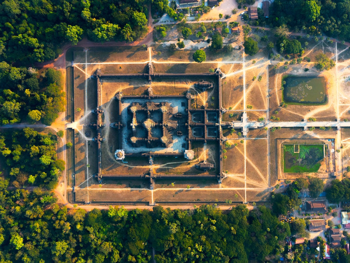
Angkor Wat sprawls across more than 400 acres as the world’s largest religious structure. The Cambodian temple complex is a network of towers, terraces, and courtyards arranged with meticulous symmetry that’s best appreciated from directly above. Built in the early 12th century as a Hindu temple dedicated to Vishnu, Angkor Wat became a Buddhist site by the century’s end.
Visitors can observe many of Angkor Wat’s defining features from the several available helicopter tours of the site, which provide a unique alternative to exploring its remote jungle location on foot. The five soaring towers represent the peaks of the sacred peak Mount Meru, while the tiered stone terraces resemble mountain slopes. Though no doubt impressive on the ground, Angkor Wat’s cosmic map must also be seen from above to fully appreciate its design.
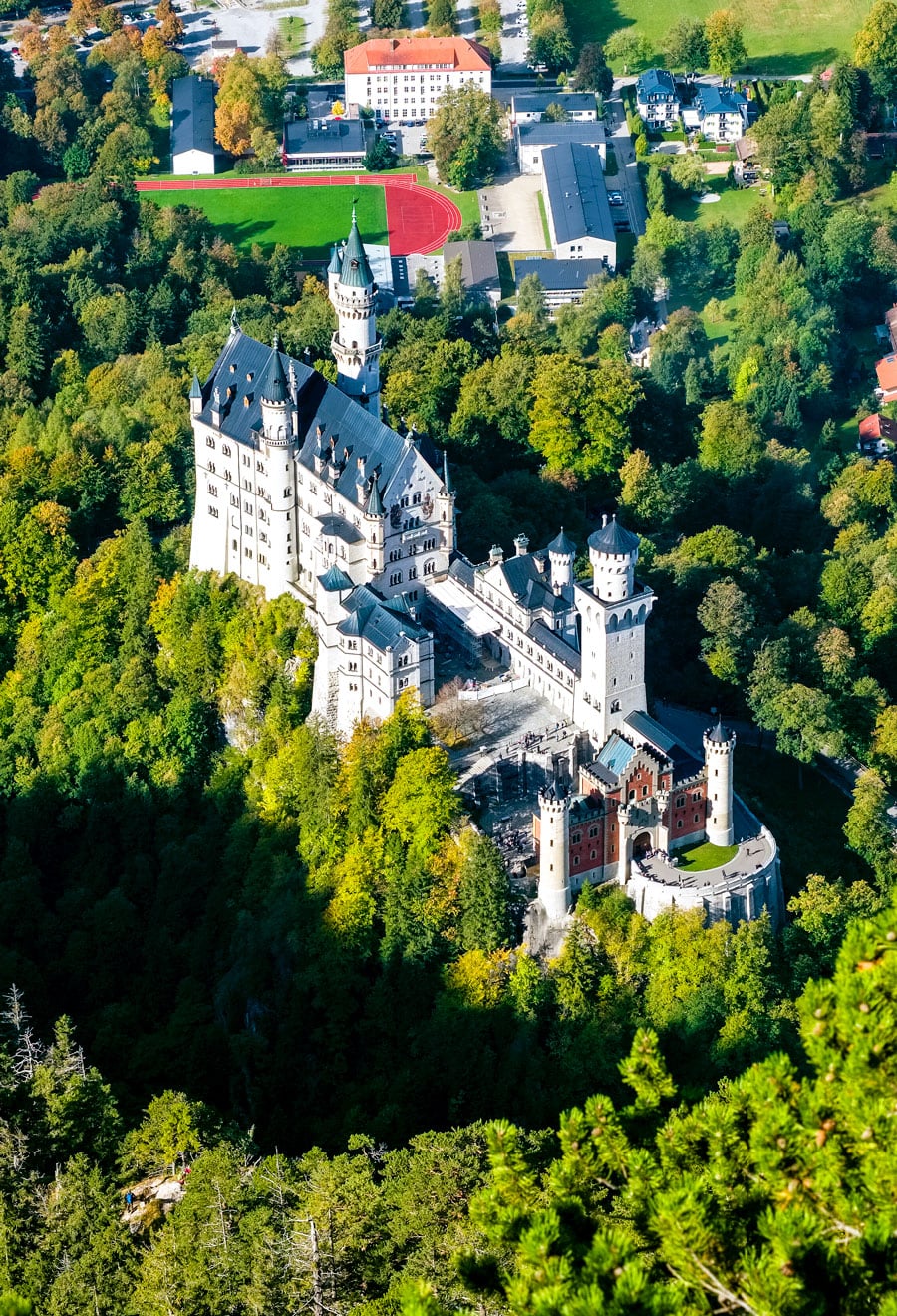
Neuschwanstein Castle – Germany
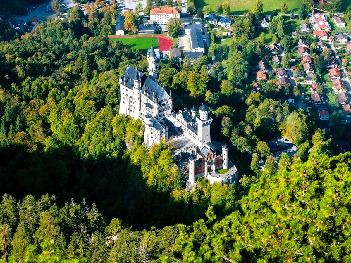
Neuschwanstein Castle famously looks straight out of a fairy tale — so much so that it even inspired Walt Disney to design Sleeping Beauty’s Castle in Disneyland in its image. Perched on a rugged hill in the Bavarian Alps, the 19th-century palace’s iconic pale towers and turrets gleam against dark green slopes and steep ravines.
Seen from above, the drama of Neuschwanstein Castle is no less spectacular, even if it does take on surprising new dimensions. From overhead, the grand castle has a narrow, asymmetrical look. Beyond the dense forest in the distance, modest towns and villages are also visible from a bird’s-eye view, providing a stark contrast to the palace’s opulence. The aerial view — available in detail via drone-filmed video tours — helps illuminate the meticulous planning that went into making Neuschwanstein magical from every angle.
Chichen Itza – Mexico
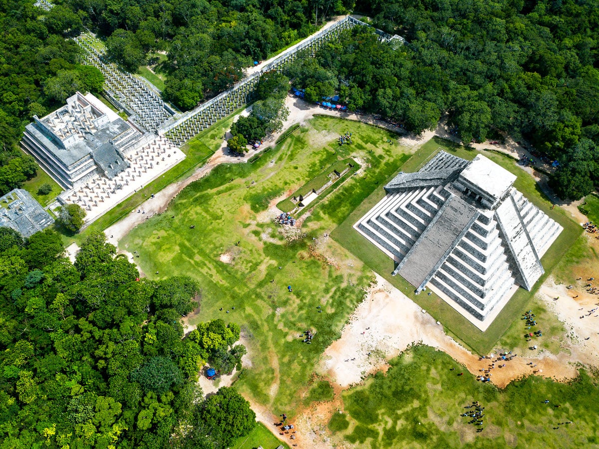
The Maya archaeological site Chichen Itza can feel quite spread out on foot, but from above, the deliberate design comes into focus. At its peak between around 950 and 1200 CE, it was the most populous city in the Yucatán Peninsula. At its center sits the pyramid known as El Castillo, which, viewed from above, highlights the intended symmetry and intricacy.
An overheard view also allows a striking look at the Temple of Warriors and the Thousand Columns. Though the bas-relief detail throughout these structures isn’t visible at this vantage point, you can get a sense of the roof and painted frieze the columns once supported. Walking around Chichen Itza might feel like visiting a site of scattered monuments, but an aerial view does its cohesive and visually striking planning proper justice.
More from our network
Daily Passport is part of Inbox Studio, an email-first media company. *Indicates a third-party property.