


Top 10 Longest Rivers in the U.S.
Top 10 Longest Rivers in the U.S.
Browse a map of the world and you’ll probably notice that many cities and towns are located close to rivers. This is not some strange coincidence: From the smallest villages to the world’s largest metropolises, rivers are a vital source of water and means to facilitate trade. They are the arteries of the Earth, making it possible for humans to reach and connect with the remotest of places. The United States alone is crisscrossed by some 3 million miles of rivers, displaying centuries of history and culture along their shores. These are America’s 10 longest rivers.
10. Ohio River – 981 miles

Flowing nearly a thousand miles from Pittsburgh, Pennsylvania, to its confluence with the Mississippi River in Illinois, the Ohio River is often called the “Gateway to the West.” It crosses or borders six states: Illinois, Indiana, Kentucky, Ohio, Pennsylvania, and West Virginia.
The river supports 160 fish species and provides drinking water to over 5 million people. Moreover, the Ohio River Basin is home to approximately 30 million people, and more than 184 million tons of cargo are transported annually on the river. Several major bridges cross over the Ohio River, including the John A. Roebling Suspension Bridge, once the longest in the world with a central span of 1,057 feet, and the pedestrian-only Purple People Bridge.
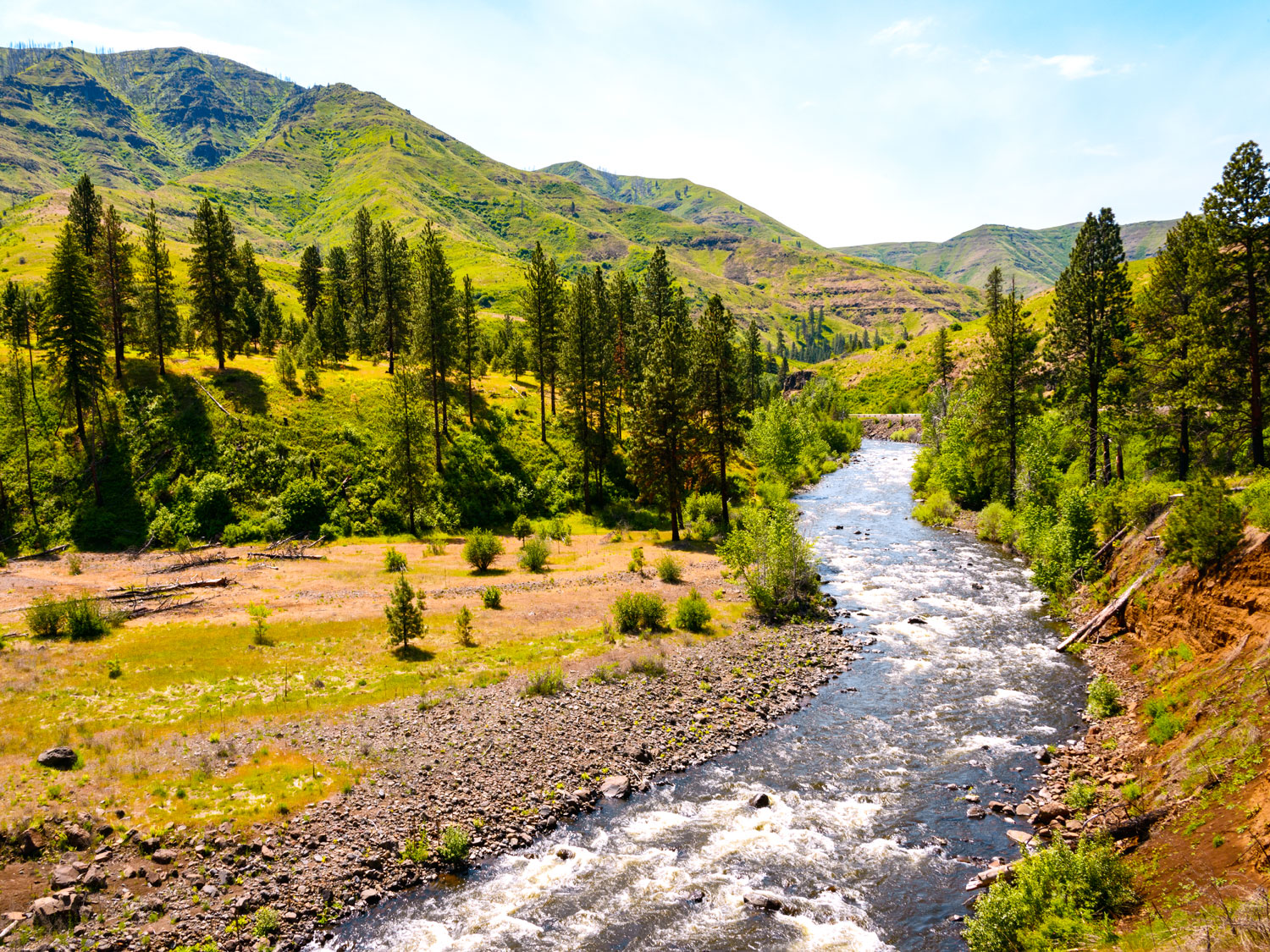
9. Snake River – 1,078 miles

The Snake River winds through the Pacific Northwest, starting in Wyoming’s Yellowstone region and eventually converging with the Columbia River in Washington. On its 1,000-plus-mile journey, it also crosses Idaho and Oregon, with a drainage basin of approximately 108,000 square miles. The Snake River has helped shape a number of famous natural landmarks, such as the 8,000-foot-deep Hells Canyon and Grand Teton National Park’s Oxbow Bend.
An estimated 300 fish species thrive in the Snake River region (it’s the Lower 48’s largest freshwater salmon habitat), as do other wildlife such as deer, elk, grizzly bears, and moose. In Twin Falls, Idaho, you’ll find the Evel Knievel Jump Site, where the legendary motorcycle daredevil made his final jump, a failed attempt at crossing the Snake River Canyon (which he survived).
8. Columbia River – 1,249 Miles

Starting in the Canadian Rockies, the Columbia River meanders through the Pacific Northwest to the Pacific Ocean. Acting as a natural border between Washington and Oregon, it’s marked by a landscape of canyons and waterfalls. The Columbia River was once the site of the world’s largest salmon runs, and, in its heyday, spawned 30 million salmon annually. The river also provides irrigation for 600,000 acres of farmland and is home to 19 hydroelectric farms. Notable cities located on the Columbia River include Portland, Oregon; the British Columbia mountain resort of Revelstoke; and Vancouver, Washington.
7. Red River – 1,290 Miles

Originating in the Texas Panhandle, the Red River (also known as the Red River of the South) zigzags across Texas, along the Texas-Oklahoma border, and into Arkansas. It then enters Louisiana near Ida, north of Shreveport, and converges with the Atchafalaya River near Baton Rouge. The river’s name is a reference to the red soil of its bed. As the water flows, it lifts the soil to create a reddish hue.
Varied wildlife species call the river and its basin home, including alligators, beavers, and numerous fish species. With the Chisholm Trail having crossed the river, it was historically connected with Native American trade and frontiersmen settlements. Established in the 19th century, this trail was frequently used for cattle runs between Texas and Kansas.
6. Colorado River – 1,450 Miles

The Colorado River carves its way through dramatic gorges and arid plains in seven U.S. states and Mexico. It begins in Colorado’s Rocky Mountain National Park, which is one of 11 national parks through which it flows. For approximately 6 million years, the Colorado River has been shaping the Grand Canyon, which reaches depths of over 6,000 feet. Aside from being a paradise for outdoor adventurers — hiking, fishing, and whitewater rafting are among the river’s plentiful recreational activities — it also provides water to major cities such as Las Vegas, Los Angeles, and San Diego.
5. Arkansas River – 1,469 Miles

Like the Colorado River, the source of the Arkansas River is in the Rocky Mountains of Colorado. For centuries, this waterway has been associated with exploration and westward expansion. The Cheyenne and Arapaho peoples relied on it for sustenance, and Spanish explorer Hernando de Soto traversed the waters on his 1541 journey into what is now the U.S. Southwest. The Santa Fe Trail, a trade route that gained fame during the California Gold Rush, follows the river through large parts of Kansas. In Pueblo, Colorado, the Historic Arkansas Riverwalk offers boating activities, boutique shopping, and public artworks.
4. Rio Grande – 1,900 Miles

From the San Juan Range of the Colorado Rockies, the Rio Grande travels through the states of New Mexico and Texas, in addition to Mexico. Prior to emptying into the Gulf of Mexico, it skirts a section of the U.S.-Mexico border. With a catchment area of 336,000 square miles, the Rio Grande provides natural habitats for bighorn sheep, river otters, and various other wildlife.
Within its span is the Rio Grande Wild and Scenic River, a 196-mile stretch protected by the National Park System. Distinguished by desert expanses and canyons of stratified rock, it’s an ideal spot for float trips, stopping at popular tourist areas like Big Bend National Park and Boquillas Canyon Trail.
3. Yukon River – 1,980 Miles (Inside the U.S.)

Alaska’s mightiest watercourse, the Yukon River has played a significant role in the human history of the region for thousands of years. Evidence suggests that the earliest settlers traversed the Yukon’s watershed some 10,000 years ago. Between 1896 and 1899, it was one of the principal means of transport during the Klondike Gold Rush.
Starting its journey in British Columbia, Canada, the Yukon flows across the wild and remote Yukon Territory, through Alaska, and into the Bering Sea. One of the best ways to experience the river and its breathtaking surroundings is through camping, canoeing, and rafting tours. Not to be missed is Yukon-Charley Rivers National Preserve: Protecting 2.5 million acres of untamed wilderness, it offers a fascinating snapshot of life during the Gold Rush years.
2. Mississippi River – 2,350 Miles

The second-largest river in the United States, the mighty Mississippi travels through 10 states from Minnesota to Louisiana. For thousands of years, everyone from Native American peoples to European explorers, fur traders, and garrisoned troops have benefited from its riches. The Mississippi provides a natural habitat for 50 species of mammals, 145 species of amphibians and reptiles, 260 fish species, and 326 bird species.
It also holds a special place in American culture, playing a central role in novels such as The Adventures of Tom Sawyer. Highlights along the river include the Mark Twain Boyhood Home and Museum and Trail of Tears State Park, both in Missouri. The Mississippi Blues Trail explores the history of Delta Blues, which was nurtured in the Mississippi Delta region.
1. Missouri River – 2,540 Miles

Snaking from the Rocky Mountains to Missouri, where it converges with the Mississippi River, the Missouri is one of the world’s longest rivers. Its current course dates back approximately 115,000 years, when mountain streams were diverted by glaciers. Well before Lewis and Clark navigated the river on their westward journey, the river provided a vital source of food and water for the Missouri and Otoe peoples and a natural habitat for hundreds of native animal species.
Today, the Missouri also provides irrigation for farms, hydroelectric power for homes, and adventures for tourists. Outdoor enthusiasts can discover a blend of history, culture, and natural wonders at the Lewis and Clark National Historic Trail, Gates of the Mountains Wilderness Area, and Missouri Headwaters State Park, among other notable sights.
More from our network
Daily Passport is part of Inbox Studio, an email-first media company. *Indicates a third-party property.


