


8 Places Where U.S. State Borders Get Strange
8 Places Where U.S. State Borders Get Strange

Since the nation’s founding, state borders have been decided for a number of reasons, whether because of natural features (such as rivers or mountain ranges), historic transportation routes, land purchases, or political factors. But state borders don’t always crisscross the country in neat lines. Some fall into the category of enclaves and exclaves. In this case, an enclave refers to part of a state that is contained entirely within a larger area belonging to a separate state or country, while exclaves are portions of land that are geographically removed from the main part of the state. Discover eight state border irregularities in the U.S. and why they exist in the first place.
Point Roberts, Washington

Point Roberts is what’s known as a “pene-exclave” — a region that only has road access through a different country. This unincorporated community is located about 25 miles south of Vancouver, British Columbia, at the southern tip of the Tsawwassen Peninsula, the rest of which belongs to Canada.
With just 4.9 square miles of total area, Point Roberts wasn’t exactly a hotly contested region. It was simply declared a part of the U.S. due to the fact that it extends south of the 49th parallel, which technically forms the international boundary between the United States and Canada.
This isolated community serves as the full-time home for around 1,200 Americans, though it is a popular tourist destination during the summer for its bird-watching opportunities. However, to access Point Roberts by car, you’ll need to drive north into Canada and travel 23 miles before crossing the border back into the U.S. You can also reach Point Roberts by plane or aboard a chartered boat.
Northwest Angle, Minnesota

A curious border oddity resulting from a mapmaker’s mistake, Minnesota’s Northwest Angle (which locals simply call “the Angle”) is the northernmost part of the contiguous United States and the only part of it that lies north of the 49th parallel.
When the Treaty of Paris was codified in 1783 (ending the Revolutionary War), it marked the U.S.-Canada border at what was thought to be the source of the Mississippi River’s headwaters; however, the line was actually drawn 150 miles north. This mistake left the Angle marooned in Canada, surrounded on three sides by Lake of the Woods and accessible only by road from Manitoba (you’ll need a passport) or by boat or snowmobile across the lake.
Upon arrival to this remote township, visitors will find a pristine wilderness perfect for fishing — indeed, Lake of the Woods proclaims itself the “Walleye Capital of the World.” There are also numerous opportunities for birdwatching, boating, camping at Northwest Angle State Forest, and R&R at the area’s several resorts. When exploring the “Top of the Nation” or the “Chimney” — two of the area’s other nicknames — don’t miss historic Fort St. Charles, a 1732 French fort and fur trading post.
Lost Peninsula, Michigan

The Lost Peninsula is a Michigan exclave that can only be accessed by land through nearby Ohio. It became a part of Michigan during the Toledo War (1835-1836), an unusual border dispute between the state of Ohio and the then-territory of Michigan.
During this bloodless conflict, both Ohio and Michigan mobilized militias to prepare for a fight over a strip of land that contains the modern-day city of Toledo. In 1836, Michigan surrendered that land over to Ohio, in exchange for the promise of statehood (which was to include portions of the Upper Peninsula attached to Wisconsin). As part of this agreement, a sliver of land north of Toledo remained under Michigan’s jurisdiction — the Lost Peninsula. There are around 140 permanent residents of this small tract of land, which is surrounded on three sides by the North Maumee Bay of Lake Erie.
Kansas City, Kansas and Kansas City, Missouri

Kansas City, Kansas, and Kansas City, Missouri, are two separately incorporated cities but are part of the same metropolitan area. Why are there two Kansas Cities? Kansas City, Missouri, was founded in 1889 — a combination of settlements named Westport (founded in 1830) and the City of Kansas (founded in 1853). It was named after the Kansas River.
By the 1870s, the City of Kansas was popular and growing quickly. Officials across the Missouri River in Kansas (which became a state in 1861) saw that and wanted to capitalize on it, so they formed Kansas City, Kansas, in 1872. The two cities are now divided by the Kansas-Missouri state line.
Elm Point, Minnesota

In addition to the Northwest Angle, another unusual speck on the map that belongs to the Gopher State — even though it looks as if it should be a part of Canada — is Elm Point. This tiny patch of land jutting out from the southeast corner of the Manitoba province technically extends past the 49th parallel, making it a part of the United States.
There’s no development on Elm Point, and the only evidence of human activity is a line of trees that’s been cut down to distinguish the U.S.-Canadian border. The exclave’s existence is simply due to the fact that it falls south of the 49th parallel, which was established as the border between the U.S. and Canada by the Treaty of 1818.
Carter Lake, Iowa

Carter Lake is the only Iowa city that’s located west of the Missouri River. It’s bordered on three sides by Nebraska and on one side by the Missouri River. The irregular border is the result of a 1877 flood that changed the flow of the Missouri River, causing an oxbow (a horseshoe-shaped bend) in this spot. Iowa and Nebraska got into a heated battle about who should own the space. The Supreme Court ruled it part of Iowa in 1892. However, Carter Lake didn’t become its own town until 1930, after it seceded from Council Bluffs, Iowa.
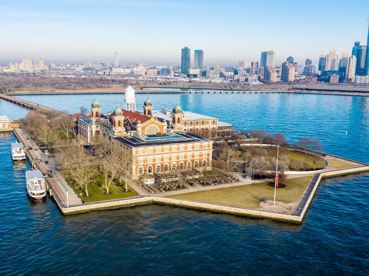
Ellis Island, New Jersey and New York

The watery border between New York and New Jersey cuts right through Ellis Island in New York Harbor — once the country’s largest immigration station, where over 12 million immigrants were processed from 1892 to 1924. The Main Building, where immigrants entered as they arrived in the United States, is located in New York.
But the island itself has been significantly expanded since then by land reclamation, and it is now 27.5 acres. New Jersey argued that the expanded portion of the island fell within its existing jurisdiction, and the Supreme Court ruled in its favor in 1998.
Finns Point, Delaware

In 1682, the Duke of York awarded William Penn a deed that granted him rights to all land west of the Delaware River, plus the waterway itself all the way over to its eastern banks. This was considered unusual because at the time, most river boundaries were divided evenly down the middle.
In the early part of the 20th century, the U.S. Army Corps of Engineers began dredging up silt from the river and depositing it along the New Jersey shore, eventually creating a tract of solid land jutting out into the Delaware River. Since all territory west of New Jersey belonged to the state of Delaware, this meant that the newly created piece of land also belonged to them.
Today it’s known as Finns Point — or as locals call it, “The Point” or “The Baja” — and it’s been the subject of three U.S. Supreme Court cases, all of which ruled in Delaware’s favor. The land doesn’t have much of a practical use today other than continuing to be a dump site for dredged-up silt.
More from our network
Daily Passport is part of Inbox Studio, an email-first media company. *Indicates a third-party property.


