


The 4 States That Border the Most Other States
Each state in the contiguous U.S. borders at least one other, but a handful of states have not just one, two, or three neighbors but as many as seven or eight. In this article, we’ll take a closer look at the four states that border the most of the bunch, and the fascinating ways those borders were drawn in the first place.
Colorado
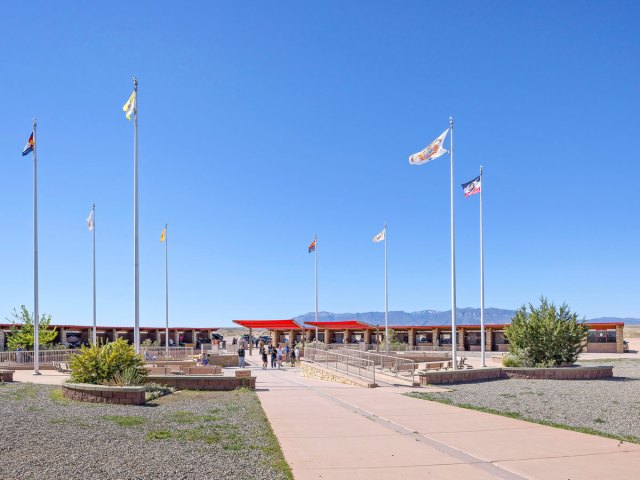
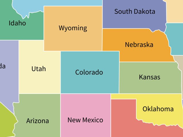
Colorado is one of two states that border seven neighboring states. If you glance at a map, you may assume that Colorado is a perfect rectangle, but there are a number of small quirks along its borders, resulting in a whopping total of 697 sides. The most famous of Colorado’s borders is located in the southwest corner of the state at the Four Corners Monument, where Colorado, New Mexico, Arizona, and Utah all meet at a single point. This is the only spot where Colorado and Arizona touch, as well as the only place in the country where four states meet.
Colorado’s entire western border is shared with Utah, and it largely follows a straight line. To the north, Colorado and Wyoming share an extensive border that runs just south of Wyoming’s capital city of Cheyenne. Nebraska wraps around Colorado’s northeastern corner, while the rest of Colorado’s eastern border is shared with Kansas.
To the south, Colorado borders two states: Oklahoma and New Mexico. Colorado sits next to Oklahoma’s Cimarron County, which is the only county in the country to touch five states: Oklahoma, Colorado, New Mexico, Kansas, and Texas. The remainder of Colorado’s southern border is shared with New Mexico, bringing us back to the Four Corners Monument.
Kentucky
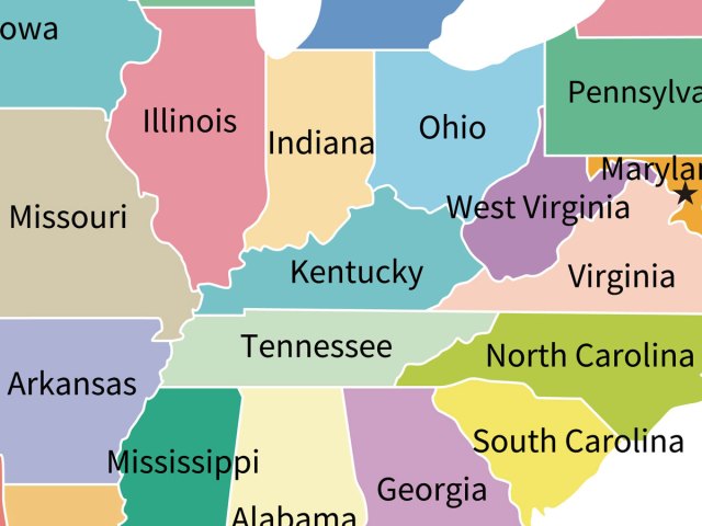
Kentucky also borders seven neighboring states. Let’s begin with the simple part: The Bluegrass State’s entire southern border is shared with Tennessee.
Meanwhile, both Kentucky’s western and northern borders are formed by rivers. To the west is the Mississippi River, which separates Kentucky from Missouri. To the north, you’ll find the Ohio River, which forms Kentucky’s jagged northern border, separating it from Illinois, Indiana, and Ohio.
The state’s eastern border has a fair bit of history. When Kentucky became the 15th state in 1792, it was established using land from Fincastle County, which was formerly a part of Virginia. Its eastern border was — and still is — largely defined by two natural features: the Big Sandy River and the Cumberland Mountains. For 71 years, Kentucky’s eastern border was shared exclusively with Virginia. But in 1863, West Virginia broke off from Virginia to become its own state, and, suddenly, Kentucky had a brand-new neighbor.
Missouri
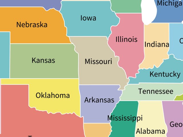
Missouri is one of only two states that border eight others. Let’s start in the north, where you’ll find the border with Iowa, which largely runs in a straight path along the Sullivan Line. This 1816 boundary was intended to delineate the Missouri Territory from the lands of the Osage Nation, but it later became the subject of an 1839 territorial dispute known as the Honey War, in which the state of Missouri and the Iowa Territory contested the exact specifications of the Sullivan Line. The U.S. Supreme Court ultimately ruled in Iowa’s favor. However, a small easternmost portion of the Missouri-Iowa border juts south from that line, traveling along the Des Moines River until it converges with the Mississippi River, which is where the border between the two states ends.
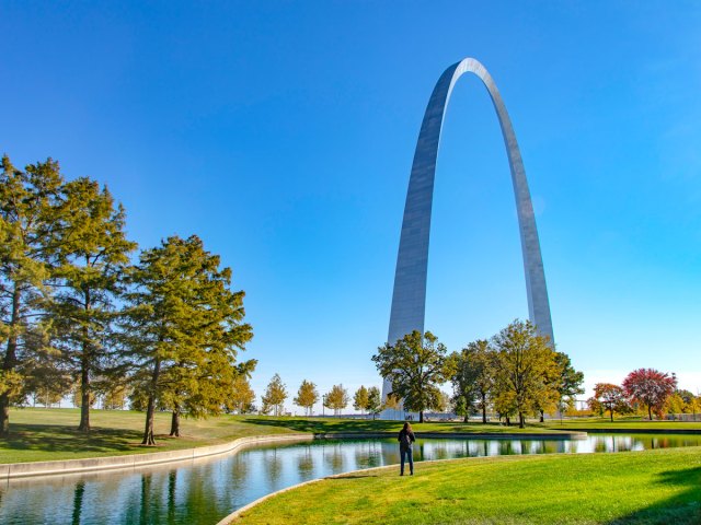
Missouri’s eastern border runs along the Mississippi River, and the vast majority of this eastern boundary is shared with Illinois. Also along Missouri’s eastern border, you’ll find the city of St. Louis and the iconic Gateway Arch. As you travel farther south, you’ll arrive at the part of the river that forms the Missouri-Kentucky border, before finally arriving at the Missouri-Tennessee border.
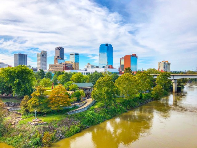
Missouri shares its entire southern border with Arkansas, including an odd geographical bit at the easternmost end called the “Missouri Bootheel.” Initially, Missouri’s southern border was intended to run straight along the 36 degrees 30 minutes north parallel; however, a man named John Hardeman Walker swayed local officials to change course.
In the 1810s, Walker — who lived in the Bootheel region — argued that the land should be included in the new state of Missouri instead of remaining part of the Arkansas Territory. Walker wanted to be part of a new state, rather than an existing territory, and those who lived in the region hoped to maintain strong existing economic ties with the Missouri communities to the north. Walker succeeded, and the borders were redrawn to accommodate this request prior to Missouri’s admission to the Union in 1821.
To the west, Missouri shares a small part of its border with Oklahoma to the south and Nebraska up north. But the majority of the state’s western border is shared with Kansas. This includes the Kansas City metropolitan area, which is divided into distinct cities on both sides of the border. Missouri’s side includes some of the metro area’s most notable attractions, including the National WWI Museum and Memorial, as well as both the Royals baseball and Chiefs football teams.
Tennessee
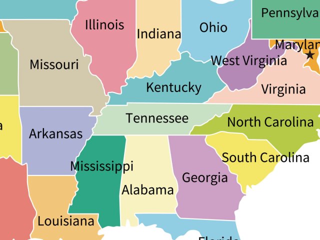
Of the eight states that Tennessee borders, two are located along its northern edge: Kentucky and Virginia. First, let’s talk about Kentucky. While the Tennessee-Kentucky border largely runs in a straight line, there are some small, yet notable exceptions, including a portion known as the “Triangular Jog.”
Here, the Kentucky border dips 3 miles into Tennessee, which is due to an error made by land surveyors in 1780, who were reliant on imperfect measurements. This mistake was discovered in the 19th century, but the Triangular Jog remained in place. The Tennessee-Virginia portion of the northern border also primarily runs in a straight line, bisecting the city of Bristol along the way.
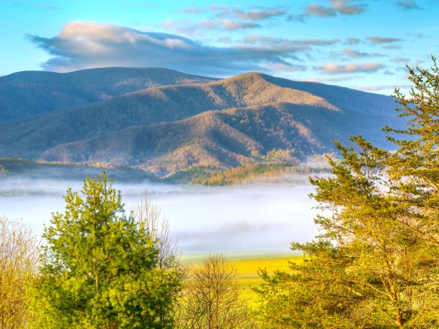
To the east, Tennessee shares its entire border with North Carolina, with the boundary cutting through the Great Smokies, a subrange of the Appalachian Mountains. Great Smoky Mountain National Park, the most-visited U.S. national park, lies on both sides of the Tennessee-North Carolina border.
In the south, Tennessee borders Georgia, Alabama, and Mississippi. When Tennessee gained statehood in 1796, the southern border was meant to run along the 35th parallel; however, that border was errantly placed a mile south, dipping into the state of Georgia. While some Georgians continue to dispute that boundary today, the border is still largely accepted as the line between the states.
Tennessee’s western border runs along the Mississippi River. On this side of the state, you’ll find a shared border with Missouri to the north and Arkansas to the south. Memphis is located in the state’s southwestern corner, where it borders both Arkansas and Mississippi. The city is home to major attractions such as Elvis Presley’s Graceland and Beale Street, the latter of which played a pivotal role in the history of blues music.
Other Neighborly States
While there are only four states that border at least seven others, the numbers skyrocket from there. For example, 11 states border six others. These are Arkansas, Idaho, Illinois, Iowa, Nebraska, New York, Oklahoma, Pennsylvania, South Dakota, Utah, and Wyoming. And then there are 10 states that border five others, 10 that border four others, and nine that border three others. Interestingly, only one state can claim to border just one other state — Maine, which borders New Hampshire.
More from our network
Daily Passport is part of Inbox Studio, an email-first media company. *Indicates a third-party property.