


Blurry Borders & Strange Sinkholes: 6 Unusual Coastlines to Visit
Blurry Borders & Strange Sinkholes: 6 Unusual Coastlines to Visit


Some coastlines consist of simple and serene sandy beaches. Others captivate with their dramatic beauty or unique features like colorful sand and famous surf. Still others have geographical quirks and geological mysteries that aren’t easily explained. From a coastline with a jarring time zone difference to a mapping mistake that causes blurry border boundaries, here are six of the world’s weirdest coastal regions.
Smoking Hills – Canada
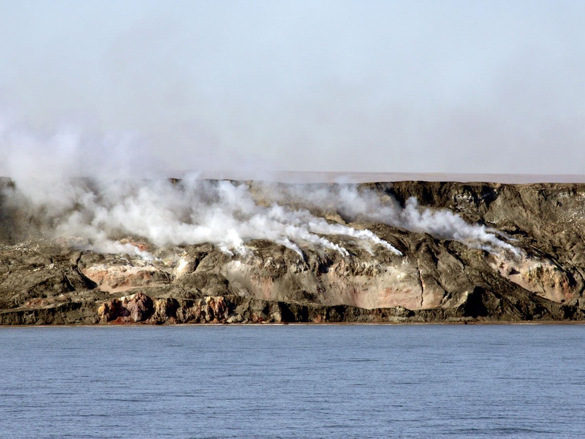
On the coast of the frigid Arctic Ocean in Canada’s Northwest Territories, a surreal site has been smoldering for thousands of years. Known as the Smoking Hills, these shale rock formations are embedded with sulfur-bearing minerals that, when exposed to air, release plumes of sulfur dioxide gas into the air.
Surprisingly, the fiery phenomenon exists on one of the few North American peninsulas that extends far enough north to cross the 70th parallel. Scientists are interested in the Smoking Hills’ rocky, red coast as an analog site for another famously red surface: Mars. Similar sulphate minerals have been detected on the Red Planet and are very rare on Earth. The strange shore could help expand our understanding of Martian geology — and even potential habitability.
Neum Corridor – Bosnia and Herzegovina
Despite its proximity to the Adriatic Sea, the Balkan nation of Bosnia and Herzegovina has only 12 miles of coastline — the rest of it is blocked by Croatia. The strange coastal boundary is the result of a series of conflicts and power shifts throughout history. During the Great Turkish War in the late 17th century, the city of Dubrovnik aligned with the Ottoman Empire, eventually ceding to the Ottomans a small area that would become known as the Neum Corridor.
After the breakup of Yugoslavia, Croatia gained independence but found itself divided. The Neum Corridor effectively separates the city of Dubrovnik from the rest of Croatia. It also serves as Bosnia and Herzegovina’s only section of unusually short coastline. The corridor historically posed tourism limitations for both countries, with multiple international borders in play. But in 2022, the opening of the Pelješac bridge directly connected the north and southern regions of Croatia for the first time.
Northwest Angle – Minnesota
Northwest Angle, a small Minnesotan community on Lake of the Woods, is bordered by the Canadian provinces of Manitoba to the west and Ontario to the north and the east. The northernmost point of the contiguous U.S., the community is disconnected from the rest of the country and accessible only by traveling by road through Canada or by boat across the lake. Interestingly, the geographical anomaly was the result of a mapping accident.
In the late 1700s, when drawing up borders between the U.S. and what was then the British territory of Canada, officials decided the line would extend in a northwest direction through the Lake of the Woods towards the Mississippi River. But in reality, the Mississippi ran south of there, not west. Despite an attempt to fix the error, the treaty of 1818 set the northern boundary for the U.S. along the 49th parallel. That drew a line south from the northernmost point of Lake of the Woods and cut off the patch of land now known as the Northwest Angle. “The Angle,” as locals call it, thus became the only place in the U.S. (outside of Alaska) to lie north of the 49th parallel.
Socotra – Yemen
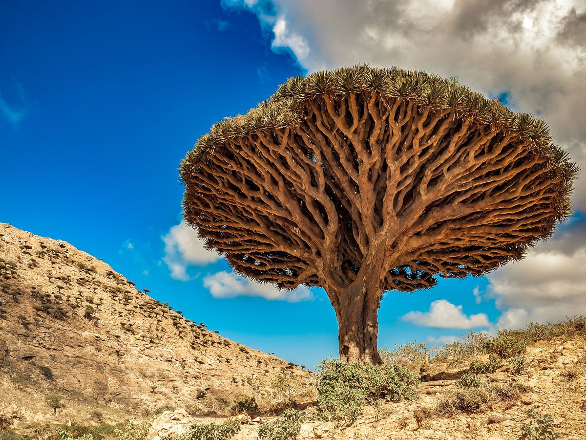
The island of Socotra, part of an archipelago of the same name in the Indian Ocean, is technically part of Yemen, but geographically, Socotra is considered part of Africa. It’s one of the world’s most remote landforms of continental (not volcanic) origin. Originally part of the ancient southern supercontinent of Gondwana, its landscape has been called the most “alien looking place on Earth.” And its isolation has fostered the evolution of hundreds of endemic species, including the famous dragon’s blood tree.
Socotra’s island geography means it has no shortage of shoreline and coastal plains. Seemingly endless rolling sand dunes reach over 300 feet high in places, before dropping into the Arabian Sea. Elsewhere, the coastal Detwah Lagoon stuns with its serene ribbons of white, soft sand that are interlaced with stretches of turquoise sea water — all set against the island’s trademark limestone plateau cliffs.
Diomede Islands – Alaska and Russia
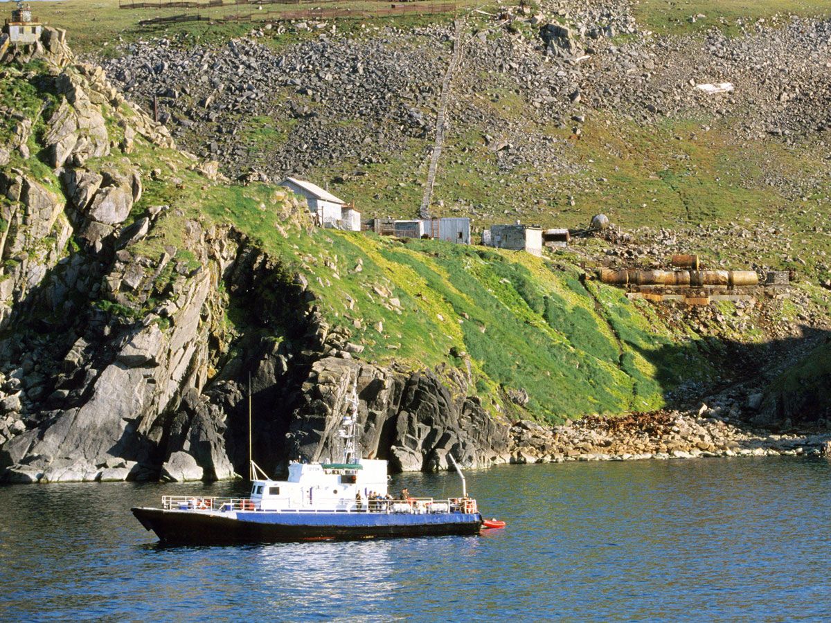
The Diomede Islands are a pair of islands in the Bering Strait, located between the Pacific and Arctic oceans. The two islands sit only about 2.5 miles apart, but in that short distance exists both the international border between Russia and the U.S., and the International Date Line. This means that each of the islands belongs to a different country: Big Diomede is part of Russia, while Little Diomede is part of the United States by way of Alaska.
It also means that there’s a time difference of almost 24 hours between the two islands — a gap that has earned them the nicknames Tomorrow Island (Big Diomede) and Yesterday Island (Little Diomede). The island of Big Diomede has no permanent population; its eastern coastline is home to only a Russian weather station. Little Diomede, however, is home to a small Native Alaskan community of about 100 people, who have called the island’s western coastline home for about 5,000 years.
Thor’s Well – Oregon
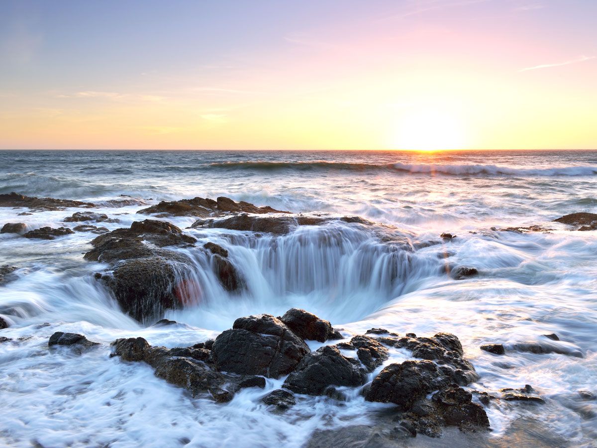
The Oregon coast is known for its rugged natural beauty and lush greenery, but Thor’s Well might be one of its most unusual (and unusually named) sights. Located near the small coastal city of Yachats, the sinkhole is believed to be the remnants of a collapsed sea cave.
Throughout the course of a day, water rushes into and over the seemingly endless pit. (Its actual depth is about 20 feet.) When the waves recede, it turns into a powerful churning whirlpool, draining away into the depths of the Pacific. During high tide, Thor’s Well is also known to spout water like a geyser. This so-called “Drainpipe of the Pacific” is part of a larger area known as Cape Perpetua, itself a coastal marvel. It’s known for its massive forested headland that juts out over the Pacific, creating the highest viewpoint accessible by car on the Oregon coast.
More from our network
Daily Passport is part of Inbox Studio, an email-first media company. *Indicates a third-party property.


