


Midwest or Northeast — How Are the U.S. Geographical Regions Defined?
Midwest or Northeast — How Are the U.S. Geographical Regions Defined?


Have you ever wondered if a state like Kansas is considered part of the Midwest or the West? Fortunately, there’s an answer for that. The United States Census Bureau divides the country into four distinct geographical regions: the Midwest, the Northeast, the South, and the West. Those are further divided up into more specific areas, such as New England and the South Atlantic. All of these regions have vast geological, cultural, and population differences. Here’s how each different region of the U.S. is officially defined, according to the census.
Midwest
Twelve states are part of the Midwest region, found in the northern center of the United States. The region is broken down further into the East North Central region (which includes Illinois, Indiana, Michigan, Ohio, and Wisconsin) and West North Central region (Iowa, Kansas, Minnesota, Missouri, Nebraska, North Dakota, and South Dakota).
There are nearly 70 million people living throughout the Midwest. Illinois is the Midwest’s most populous state with around 12.5 million residents, while North Dakota is the least populous at around 780,000 people.
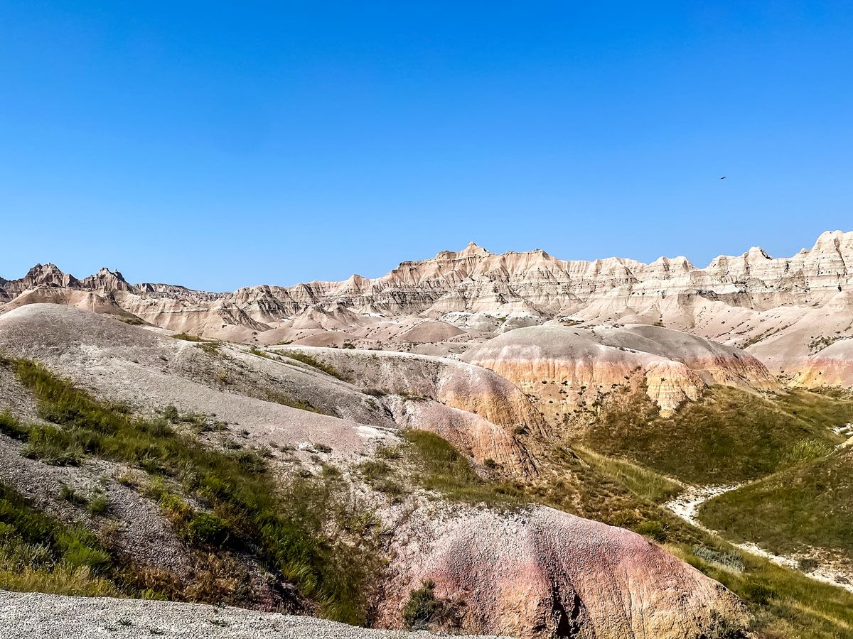
Six of the Midwest states border the Great Lakes, a defining natural feature of the region. Michigan alone borders Lakes Erie, Huron, Michigan, and Superior. The Midwest is also home to eight national parks, including Missouri’s Gateway Arch National Park (the country’s smallest national park) and South Dakota’s Badlands National Park. South Dakota is also where you can find Mount Rushmore, as well as America’s geographic center, located in the town of Belle Fourche. The Midwest also has a strong connection with American political history, as there are 11 presidential birthplaces located throughout the region, including seven in Ohio alone.
Northeast

The Northeast, nestled between Canada and the Atlantic Ocean, contains nine states. The region is further divided into two sections: New England (consisting of Connecticut, Maine, Massachusetts, New Hampshire, Rhode Island, and Vermont) and the Middle Atlantic (New Jersey, New York, and Pennsylvania). Seven of these states border the Atlantic Ocean; Pennsylvania and Vermont are the sole exceptions.
The Northeast is home to approximately 57 million residents, which makes it the least populous of the four Census-defined regions. The most populated state in the Northeast is New York, home to roughly 19.5 million people and the country’s largest city, New York City. Interestingly, the Middle Atlantic (with 41 million residents) has more than double the total population of New England (about 16 million residents).
There’s only a single national park located in the Northeast — Maine’s Acadia National Park — but the region has plenty of other incredible natural landmarks. These include Niagara Falls in northern New York, as well as the beach haven of Cape Cod, which extends out into the Atlantic from Massachusetts. There are plenty of historic human-made landmarks, as well, including some of the oldest buildings in the country. Rhode Island is also home to the White Horse Tavern, which is America’s oldest continuously operating restaurant, open since 1673.
South

The South encompasses 16 states, plus Washington, D.C. That includes all of the states bordering below New Jersey and the Mason-Dixon Line, as well as the states that share a border with the Gulf of Mexico. The region is divided into three segments: the South Atlantic region (Delaware, Florida, Georgia, Maryland, North Carolina, South Carolina, Virginia, West Virginia, and also Washington, D.C.), the East South Central region (Alabama, Kentucky, Mississippi, and Tennessee), and finally the West South Central region (Arkansas, Louisiana, Oklahoma, and Texas).
There are roughly 130 million Americans living throughout the South, making it the most heavily populated geographic region in the U.S. Of all the Southern states, Texas leads the pack with 30.5 million people, while Delaware — the country’s first state — brings up the rear with just over a million residents.
There are 11 national parks found throughout the South, including Mammoth Cave in Kentucky, home to the world’s longest known cave system with over 400 miles explored. There are also parks with tremendous ecological importance, such as the Florida Everglades, which is the only place in the world where alligators and crocodiles coexist. For history buffs, there are many important Civil War-era battlefields located throughout the South — including Antietam in Maryland, Harper’s Ferry in West Virginia, and Vicksburg in Mississippi. The South is also a political heavy hitter: Virginia has produced the most Presidents of any state, with eight.
West

The fourth and final region of the United States is the West, which is the largest by total area at approximately 1.74 million square miles — accounting for roughly half of the entire country. The American West is broken down into the Mountain zone (Arizona, Colorado, Idaho, Montana, Nevada, New Mexico, Utah, and Wyoming) and the Pacific (Alaska, California, Hawaii, Oregon, and Washington).
The region contains the country’s largest state by area (Alaska and its 586,000 square miles), the country’s most populous state (California and its 39 million residents), and its least populous state (Wyoming, with 583,000 residents). All told, there are around 78 million people who call the West home.
The West contains 41 of the country’s 63 national parks, far more than any other region. A record nine of those are located in California — including sites like Yosemite and Redwood — while there are eight in Alaska, including America’s largest national park, Wrangell St. Elias (13.2 million acres). Yellowstone National Park sits atop an underground supervolcano known as the Yellowstone Caldera. This 1,350-square-mile caldera is unlike any other geological feature known throughout the country, and last erupted around 640,000 years ago. Other unique aspects of Western geography include the towering hoodoo rock formations in Utah’s Bryce Canyon, as well as the country’s deepest lake — Oregon’s Crater Lake, which descends to a depth of 1,943 feet.
More from our network
Daily Passport is part of Inbox Studio, an email-first media company. *Indicates a third-party property.


