19,000 Miles, 14 Countries: What It’s Like to Drive the World’s Longest Road
19,000 Miles, 14 Countries: What It’s Like to Drive the World’s Longest Road
When conversations about road trips come up, famous journeys along the Pacific Coast Highway, Route 66, and Australia’s Great Ocean Road are often mentioned. But for an epic road trip adventure to beat all others, there’s really only one option: the Pan-American Highway. The world’s longest motorable road stretches for a whopping 19,000 miles across the Americas, starting in Prudhoe Bay, Alaska, and ending in Ushuaia, Argentina. Below, discover the fascinating history of the Pan-American Highway and the highlights you shouldn’t miss on your epic road trip.
The History of the Pan-American Highway
The concept for the Pan-American Highway dates back to the First International Conference of American States in 1889. At the event, U.S. officials put forward an idea to build a transcontinental railroad to provide closer transport links and facilitate trade between neighboring countries. However, nothing came of the proposal until it was reintroduced as a motorable road at the Fifth International Conference, held in Chile in 1923. The idea was eventually approved in Cuba in 1928, and the participating nations signed the Convention on the Pan-American Highway in 1937.
Rather than being one official continuous road, the Pan-American Highway is an interconnected network of national highways in 14 countries. Starting in Alaska, it crosses through Canada, the lower 48, Mexico, Guatemala, El Salvador, Honduras, Nicaragua, Costa Rica, Panama, Colombia, Ecuador, Peru, and Chile, before ending in Argentina’s southern Patagonia region. The first completed section was the 3,400-mile-long Inter-American Highway that connects Nuevo Larredo, Mexico, with Panama City, Panama.
Since the highway’s inception, adventurous travelers have been lured by the opportunity to drive all the way from the Arctic Circle to the edge of Antarctica. While some take it slow, others take on the challenge of getting from the start to end in record-breaking times. In 2003, Tim Cahill and Garry Sowerby drove from south to north in 23 days, 22 hours, and 43 minutes. It is often cited as the record for the fastest trip by car. In 2018, Austrian cyclist Michael Strasser completed the journey on bicycle in 84 days, 11 hours, and 50 minutes — a Guinness World Record. Perhaps even more impressive is George Meegan, who walked the entire length from Ushuaia to Prudhoe Bay in a record 2,426 days.
Driving the Pan-American Highway Today
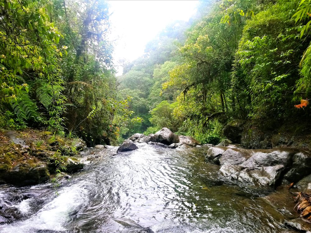
The beauty of traveling the Pan-American Highway is the ability to discover a huge variety of natural and urban landscapes along the way, along with myriad cultures, climates, and ecosystems. Among these many highlights are the glaciers and icefields of Alaska and Canada’s Yukon Territory, and major cities such as Albuquerque and Denver. Farther south, there are dramatic Andean peaks, verdant jungles, and the world’s driest nonpolar desert. The highway also passes through Quito, one of the world’s highest capitals.
An end-to-end road trip isn’t without its limitations, however. The Pan-American Highway terminates abruptly in Yaviza, in southern Panama, before picking up again 60 miles south in Turbo, Colombia. The space between these two locations is called the Darién Gap. It’s a region of difficult terrain — swampland and thick forested jungle — that is home to communities of Indigenous groups such as the Embera-Wounaan and Kuna peoples. There are no paved roads here, thus no vehicle access, and it’s also notorious for criminal gangs and smuggling. Instead, drivers have to ship their vehicle in a container and fly between Panama and Colombia.
Those tackling the entire highway have one other water crossing to navigate: In southern Chile, it’s necessary to cross the Strait of Magellan, which separates the mainland from the island of Tierra del Fuego. Fortunately, it’s a short 30-minute crossing, and the ferries are vehicle-friendly.
5 Must-See Highlights of the Highway
Whether you’re planning to cruise down a short portion of the Pan-American Highway or it’s on your bucket list to tackle the whole route, here are five stops you shouldn’t miss along your journey.
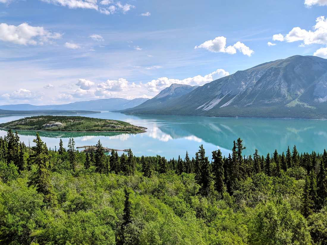
Whitehorse – Yukon Territory

After crossing the glacier and mountain-filled backcountry of Alaska, the highway enters the remote wilderness of Canada’s Yukon Territory. Whitehorse, the capital of the territory, offers insights into the daily lives of those who call these barren landscapes home. It was once an important stop during the 1898 Klondike gold rush, and legend states that the town got its name when prospectors mistook the rapids of Miles Canyon for horses. Paddle the Yukon River or follow the Yukon River Loop Trail to the decommissioned steamwheeler at the S.S. Klondike National Historic Site. Surrounding Whitehorse are 435 miles of hiking trails and more than 50 miles of cross-country ski trails.
Cerro de la Muerte – Costa Rica
At almost 11,000 feet above sea level, the zigzagging mountain pass that climbs over Cerro de la Muerte (Hill of Death) marks the highest elevation on the Pan-American Highway. Nestled amid the Talamanca Mountain Range, it’s named after the perilous crossings that were once made on foot, which were often hindered by dramatic temperature changes and landslides. Driving the pass entails navigating steep curves and switchbacks, but along the way are a number of pullouts and viewpoints, where you can gaze over the jungle-clad Talamanca mountains toward the Pacific Ocean. The region is also rich in birdlife, notably emerald toucanets and quetzals.
Nazca Lines – Peru
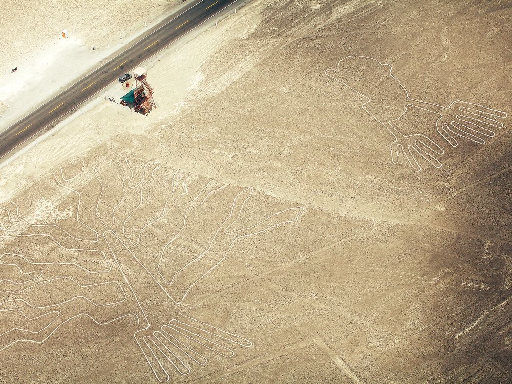
In the desert lands of southwestern Peru, the highway passes one of South America’s most mysterious sites. The UNESCO-listed Nazca Lines are a collection of hundreds of giant geoglyphs that were etched into the sand sometime between 500 BCE and 500 CE. Measuring up to 985 feet in length, these geoglyphs depict everything from birds, flowers, and trees to a monkey and a fishermanlike figure. Who made them remains unknown, which only adds to their magical aura. One of the best ways to see them is from an observation tower located roughly 15 miles from the city of Nazca. Another way is to take a 35-minute scenic flight over 13 of the most important geoglyphs.
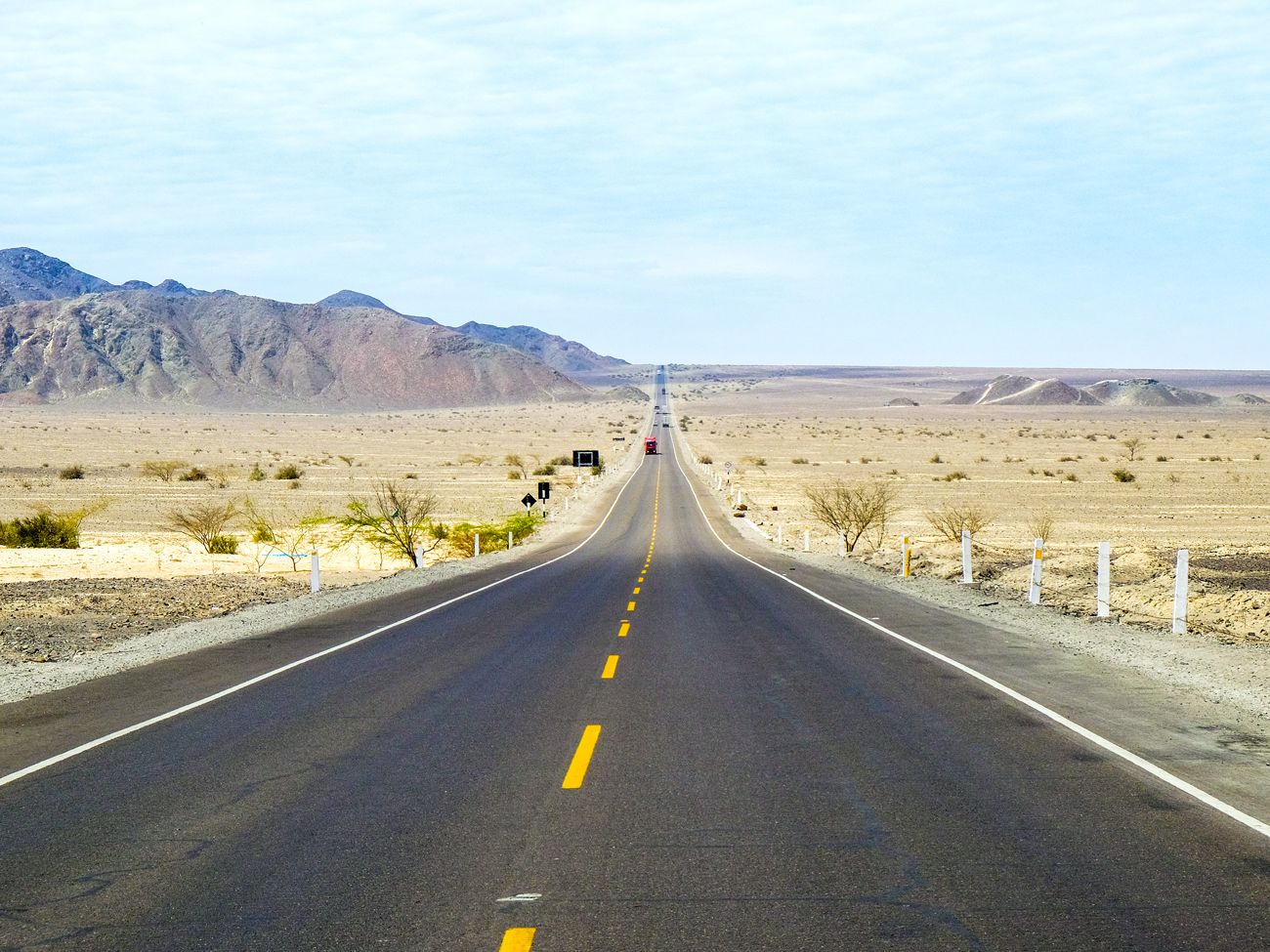
Atacama Desert – Chile
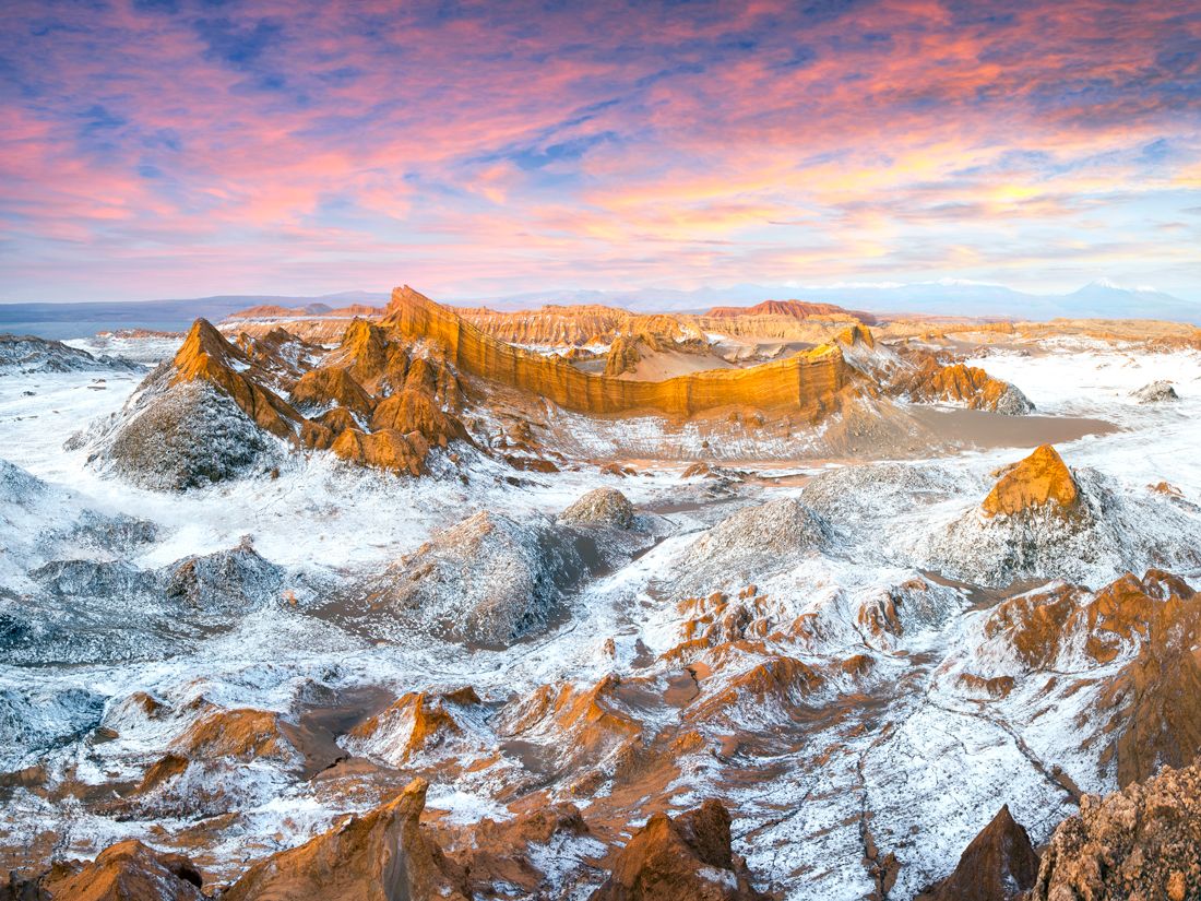
From the Peruvian border, the highway continues into Chile and the Atacama Desert. Bounded by the Andes to the east and the Pacific Ocean to the west, the desert sits at around 8,000 feet above sea level and is one of the driest places on Earth. Cruising through the 600 miles of this region involves long, lonely drives past ethereal, often inhospitable landscapes that resemble something from another planet. (In fact, NASA used the region for testing to replicate conditions on Mars.) Humberstone — a ghost town that was once a thriving saltpeter mining community — is now home to abandoned grocery stores, a hotel, and a theater that sit isolated beneath the scorching desert heat. Farther south, Chañaral is a gateway to penguin watching in Pan de Azucar National Park and surfing at Portofino Beach and Balneario Flamenco.
Ushuaia – Argentina
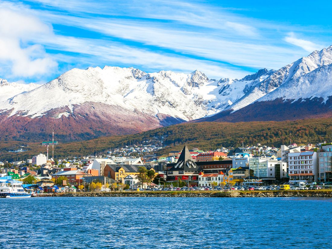
The journey on the longest road in the Americas reaches its terminus in Ushuaia, which proudly calls itself the Fin del Mundo (End of the World). Considered the world’s southernmost city, Ushauia sits on a hillside above the shores of the Beagle Channel at the bottom of Tierra del Fuego Province. It honors its extreme southerly location with a set of unique attractions such as the End of the World Train and Cerro Castor, the southernmost ski resort in the world. Visitors can also access nearby Patagonian forests and glacier lakes in Tierra del Fuego National Park and wildlife-spotting cruises on the Beagle Channel. Ushuaia is also a starting point for arduous sea voyages across the Drake Passage to Antarctica.
More from our network
Daily Passport is part of Inbox Studio, an email-first media company. *Indicates a third-party property.