Culture •November 1, 2023•Updated: November 15, 2023
By Bradley O'Neill
An estimated 4.3 billion people — over 55% of the world’s population — reside in urban settings, and that number is expected to double in size by 2050. A metropolitan area is defined as a major city and its surrounding suburbs, plus any nearby towns and cities that are directly influenced by the major city in an economic and social fashion. Below, discover the top eight largest metro areas by population on the planet.
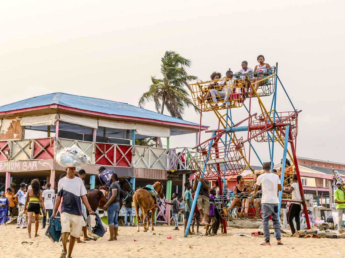
Sprawling inland from the Gulf of Guinea, the Lagos metropolitan area is the largest urban region in Africa. It is part of the Lagos state, which covers over 1,300 square miles and includes the four administrative divisions of Ikeja, Ikorodu, Epe, and Badagry. Once the capital of Nigeria until it was moved to Abuja in 1991, Lagos is a major center for culture and education, home to institutions such as the University of Lagos and Nigerian National Museum.
The geography of Lagos, a bustling port and Nigeria’s largest city, is characterized by a system of islands and lagoons connected to the mainland by bridges. By the 15th century, a large community of Yoruba fisherpeople had settled on Lagos Island. Today, Lagos is not only the Yoruba peoples’ most important city but also a melting pot of many other cultures.
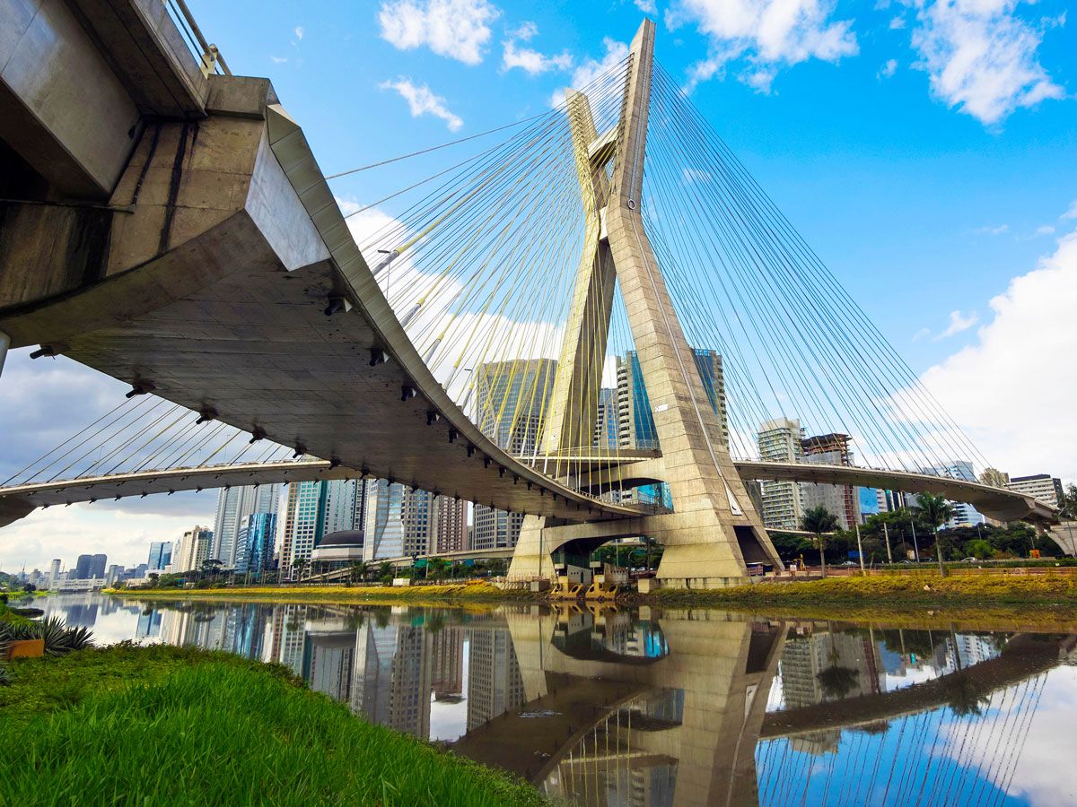
With the city of São Paulo at its core, Greater São Paulo encompasses over 3,000 square miles of municipalities and other major cities such as Guarulhos. A financial and economic powerhouse, the area is home to Brazil’s largest employment base. One of the prime factors leading to São Paulo’s economic dominance was the rise of coffee exports and industrialization in the late 1800s.
Toward the south of the metro area, the ABC Region, incorporating the municipalities of Santo André and São Bernardo do Campo, is home to major industrial and car manufacturing corporations. Famed for its vibrant food and arts scene, São Paulo features modern skyscrapers that rise above historic neighborhoods and traffic-filled streets.
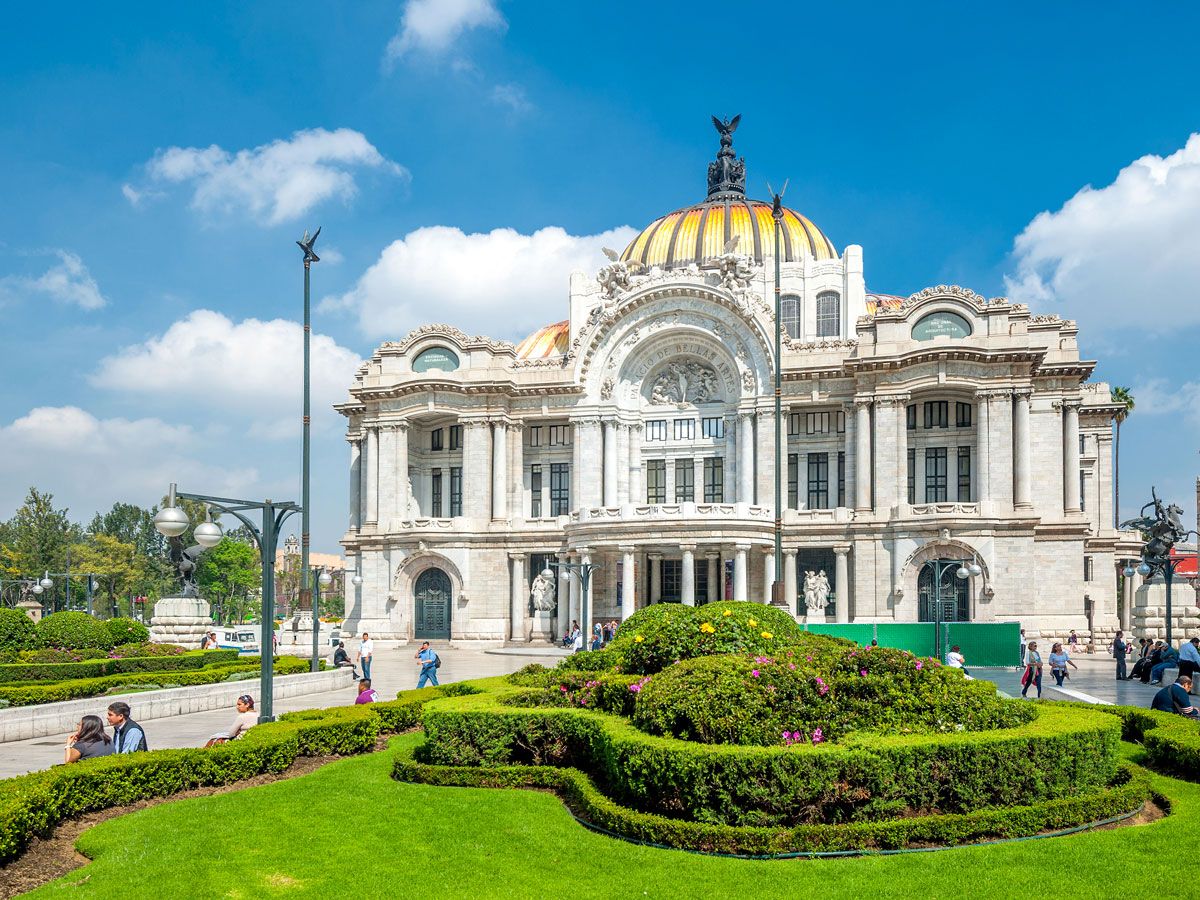
Officially called the Metropolitan Area of the Valley of Mexico, Greater Mexico City is the conurbation that wraps around Mexico City, the capital of Mexico located at 7,350 feet above sea level. It incorporates three states: the state of Mexico (aka EdoMex), Morelos, and Hidalgo. EdoMex, which borders Mexico City on all three sides, gets its original name, Mexico, from the Mexica peoples who were banished from the city by the Spanish.
Mexico City itself was built on the site of Tenochtitlan, the capital of Aztec Empire, which flourished in the area from around 1300 until the Spanish conquered it in 1521. Alongside archaeological sites such as the Templo Mayor are more modern culture treasures such as the Palacio de Bellas Artes, a vibrant street food scene, and lush urban parks.
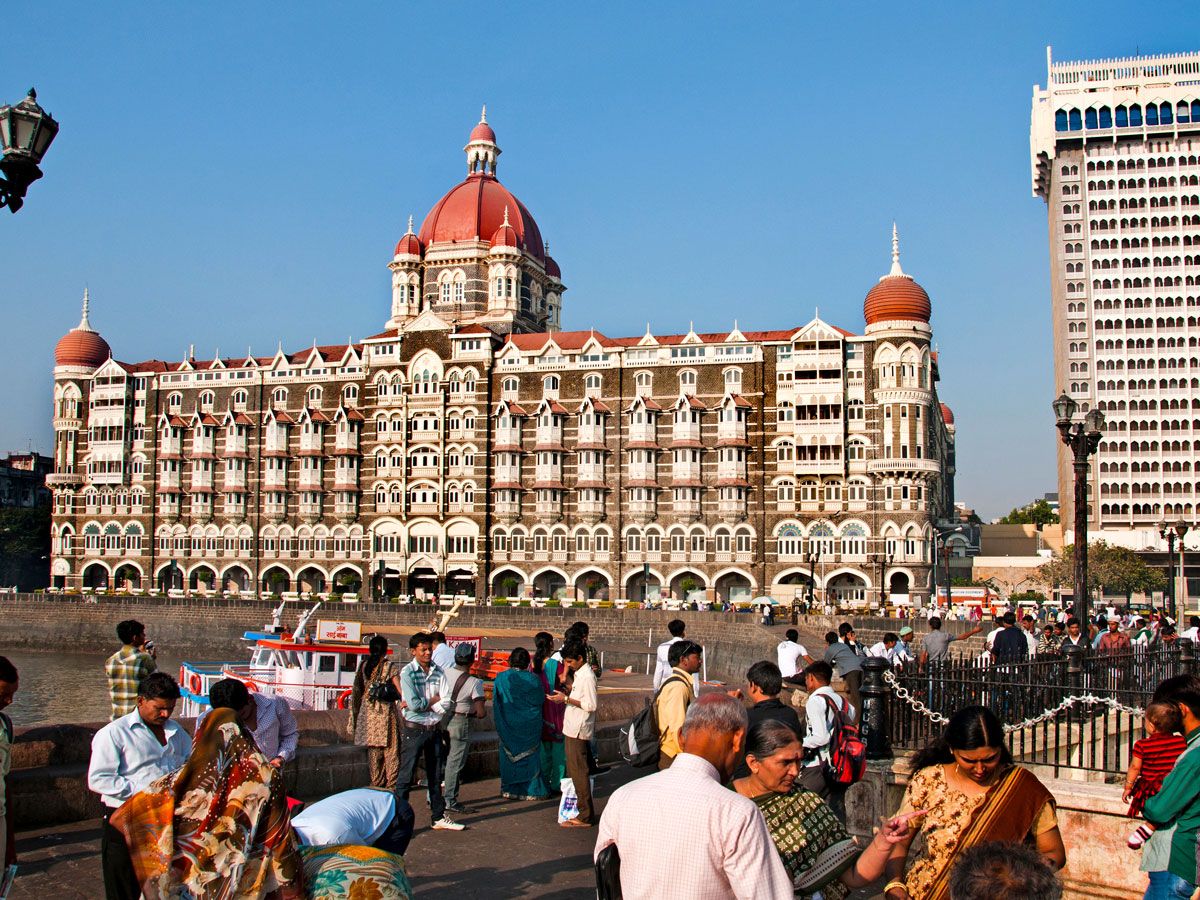
The Mumbai Metropolitan Region (MMR) forms a significant part of India’s economic and cultural landscape. Occupying around 2,450 square miles, it includes the city of Mumbai and several important districts in the state of Maharashtra, including Thane and Navi Mumbai. Also within the region are over a thousand traditional villages.
Mumbai (formerly known as Bombay) is the embodiment of old-meets-new. Here, sacred Hindu monuments like Shree Siddhivinayak Temple contrast with the glitzy skyscrapers of Bandra West. Mumbai is known for being the center of Bollywood filmmaking, for its love of cricket, and for its bustling markets. To the west, Navi Mumbai is among the world’s largest planned cities. It was built in the 1970s to ease population congestion in Mumbai proper.
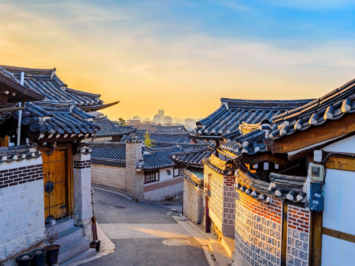
Occupying much of the northwestern part of South Korea, the Seoul Metropolitan Area is the economic, political, and cultural center of the country. This rapidly developing area accounts for almost 12% of South Korea’s land area. It includes the administrative districts of Seoul Special City, Incheon Metropolitan City, and Gyeonggi-do. As of 2021, 28 of the nation’s 77 cities were located within the metropolitan area’s boundaries.
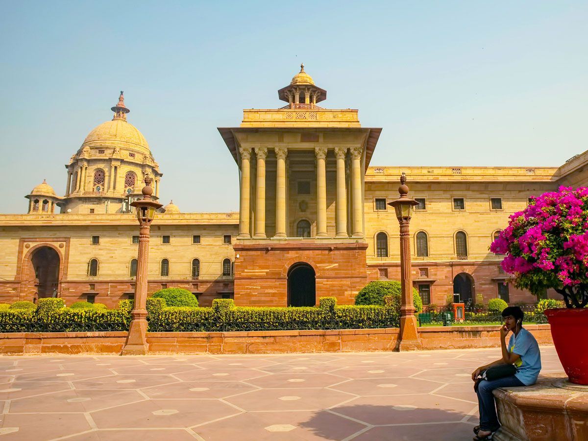
India’s National Capital Region is the country’s most populous metropolitan area. Situated in northern India, it comprises the National Capital Territory of Delhi and 20 districts scattered around the neighboring states of Haryana, Uttar Pradesh, and Rajasthan.
The region’s most important city is Delhi, which is itself split into Old Delhi and New Delhi, and home to over 11 million of the region’s nearly 30 million inhabitants. It serves as India’s capital and seat of government. Defined by a diverse and fast-paced lifestyle, Delhi is home to iconic sites like Chandni Chowk bazaar, the Red Fort, and Jama Masjid.
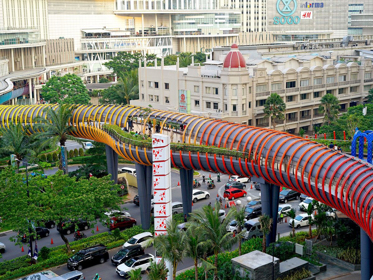
Centered on Indonesia’s vibrant capital of Jakarta, the Greater Jakarta area is made up of five cities and three regions. It’s often referred to as Jabodetabek, which is a portmanteau that uses the first two letters of the cities of Jakarta, Bogor, Depok, Tangerang, and Bekasi.
Jakarta itself is home to 10 million residents and exhibits a fascinating blend of traditional and contemporary culture. The city’s Dutch-built Kota Tua (Old Town), energetic Glodok (Chinatown), and Sunda Kelapa port contrast with the glitzy Grand Indonesia Mall and modern Museum MACAN. Yet despite Jakarta’s cultural and historical significance, there are plans to build a new capital city called Nusantara on the eastern side of the island of Borneo.
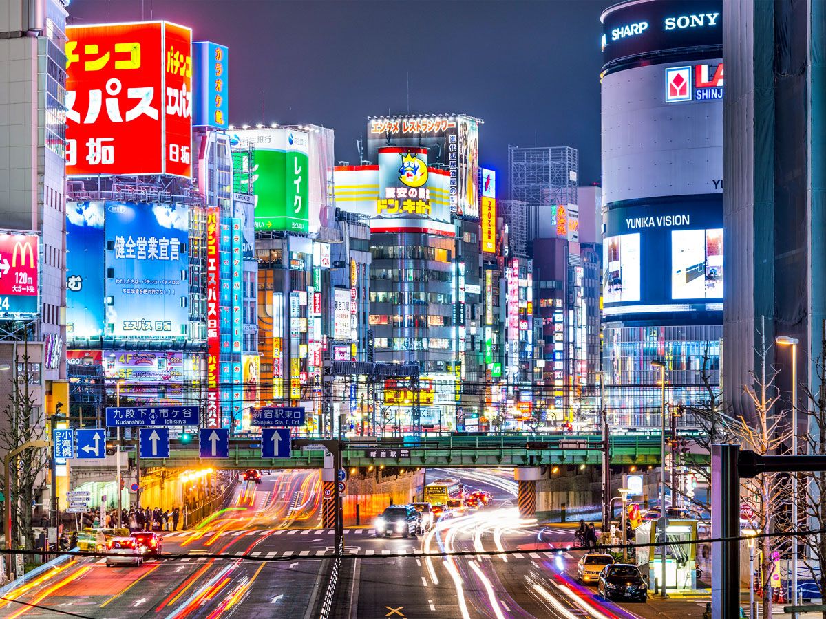
The world’s most populous metropolitan area is home to roughly 30% of Japan’s entire population. Located on the island of Honshu, itself one of the world’s most populous islands, the metro area it features not only the city of Tokyo, Japan’s capital, but also its encompassing prefectures of Saitama, Chiba, Kanagawa, Ibaraki, Tochigi, Gunma, and Yamanashi.
Throughout the region, modern infrastructure rubs shoulders with ancient buildings, all while being enveloped by striking natural beauty. In Tokyo, it’s common to look out at neon-lit skyscrapers, nearby age-old temples like Meiji Shinto Shrine, and Mount Fuji in the distance. Tochigi dazzles with volcanic scenery and Nikko National Park, while Yamanashi is considered the gateway to Mount Fuji. The area also includes the Izu and Ogasawara islands, the latter a playground for beachcombing, hiking, and wildlife watching.
Advertisement
More from our network
Daily Passport is part of Inbox Studio, an email-first media company. *Indicates a third-party property.
Want a New Apple Watch for Your Next Trip? We Have You Covered
By
Daily Passport Team
Read time: 1 minutes
November 1, 2023
Updated: November 1, 2023
Want a New Apple Watch for Your Next Trip? We Have You Covered
Outdoors •November 1, 2023•Updated: November 1, 2023
By Daily Passport Team
Author
Daily Passport Team
Daily Passport writers have been seen in publications such as National Geographic, Food & Wine, CBC, Condé Nast Traveler, and Business Insider. They're passionate about uncovering unique destinations and sharing expert tips with curious travelers.
Turn your next trip into a breeze with the latest Apple Watch, which makes it easier to navigate the globe than ever before. Leave your phone in your pocket and use the Apple Watch to quickly find what you need — whether that’s flashing your boarding pass at the airport, pulling up directions when you’re navigating a new city, or monitoring your health as you’re out there exploring our fascinating world.
What’s Included?
Valued at $429, the Apple Watch Series 9 GPS includes a 45mm Midnight Aluminum Case and a Midnight Sport Band. As a loyal Daily Passport reader, you have the opportunity to win one of the year’s hottest travel gadgets — click the link below to enter, and good luck!
Architecture •October 26, 2023•Updated: October 26, 2023
By Julia Hammond
Author
Julia Hammond
Julia is a U.K.-based travel writer whose work has been featured in The Independent, The Telegraph, The New Zealand Herald, and Culture Trip, among others. She’s an enthusiastic advocate for independent travel and a passionate geographer who has had the privilege of traveling to more than 130 countries in search of a story.
The U.S. is home to a fascinating array of architectural styles and landmark buildings. Some represent foundational moments in the country’s history, while others reflect the nation’s ever-forward thinking, using technology and construction methods to create structures that were previously thought to be impossible to build. From the birthplace of the skyscraper to the center of historic Puebloan adobe architecture, these six U.S. cities should be on any architectural buff’s travel bucket list.
The world’s first first modern skyscraper debuted in 1885 on the corner of Adams and LaSalle Streets in downtown Chicago. Just as you’ll find in New York City, the jumble of glass and steel of the Loop’s high rises reflects a continuing love affair with these supertall buildings. Some of Chicago’s most famous skyscrapers include the 1,450-foot tall Willis Tower — the tallest in the city and the tallest in the world from 1973 to 1998 — and the neo-Gothic Tribune Tower. Completed in 1922, the latter incorporates pieces from some of the world’s most famous structures, including the Taj Mahal and the Great Wall of China, into its striking facade.
Yet, when it comes to architecture, this Midwestern city is no one-trick pony. Architecture buffs should also make their way to Chicago’s southern suburbs to explore the Pullman National Historic Park. This 19th-century planned development was the brainchild of railroad magnate George Pullman, who dreamt of an industrial utopia where his workers could live in comfortable conditions within walking distance of their jobs at the Pullman Palace Car Works. Later designated the first national park unit in the city of Chicago, the community is a noteworthy example of planned urban design and historic architecture.
Construction in San Francisco accelerated as a result of the influx of residents during the California Gold Rush, which began in 1848, and was temporarily halted by the Great Earthquake of 1906. The most flamboyant of the Victorian- and Edwardian-era buildings from this period were built in the Queen Anne style and date from 1880 to 1900. These magnificent homes feature an asymmetrical facade, pedimented porches, gabled roofs, balconies, and ornate architectural details such as spindles and fretwork.
The Painted Ladies of Steiner Street, lining the eastern edge of Alamo Square Park, are perhaps San Francisco’s most famous Queen Anne buildings. Developer Matthew Kavanaugh built these homes between 1892 and 1896. Their pretty pastel paintwork echoes the color palette of Miami’s tropical-inspired Art Deco buildings, and as with Florida’s South Beach, they’ve since become one of the most photographed spots in the city.
The Big Easy’s varied neighborhoods are a treasure trove of historic architecture, from the wrought iron balconies of the Vieux Carré (French Quarter) to the stately homes of St. Charles Avenue. The Faubourg Marigny district in New Orleans was laid out at the beginning of the 19th century on plantation land owned by Bernard Philippe Xavier de Marigny de Mandeville. The neighborhood’s trapezoid shape accommodates a meander in the Mississippi River, and its historic streets offer up a melting pot of architectural influences, from French to Spanish and Creole styles.
Here, you’ll find colorful shotgun houses and shuttered Creole cottages alongside two-story buildings adorned with wrought iron balconies and galleries. (There’s a difference: Balconies are designed to be self-supporting, while galleries are propped up on poles.) Examples of Greek, Italianate, and Craftsmen architecture are also found in the neighborhood, which has a bohemian and lively feel, particularly on Frenchmen Street.
Architecture buffs can step back in time to the late 17th and early 18th centuries as they explore Boston, one of America’s oldest cities. The oldest building in downtown Boston is the Paul Revere House, constructed around 1680. Nearby, you’ll see the Old Massachusetts State House (built in 1713); the Old Corner Bookstore, Boston’s oldest commercial building (erected in 1718); and Faneuil Hall (dating to 1742), named for the wealthy merchant who gifted it to the city on its completion. They are all stops on the city’s 2.5-mile-long Freedom Trail, a must for any visitor.
However, Boston’s reputation extends far beyond those early days. For instance, the Brutalist-style Boston City Hall and Paul Rudolph’s Lindemann Center each make a bold statement, while landmarks from famed architects Frank Gehry (the Stata Center) and Eero Saarinen (Kresge Auditorium) in nearby Cambridge confront, challenge, and cheer in equal measure.
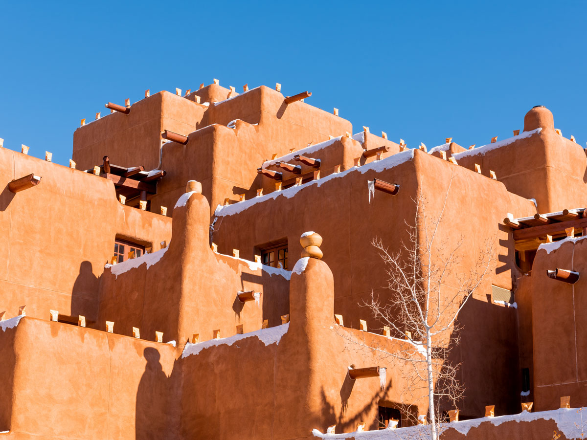
Santa Fe boasts some of the most eye-catching architecture in the U.S. This historic New Mexico city, also one of America’s oldest settlements, is proud of its long heritage and celebrates it with the conservation of the adobe buildings built by the region’s Indigenous Puebloans as early as 800 CE.
The Puebloans layered adobe onto a basic wooden framework of vigas and latillas, and the Spanish later adapted the technique in the 16th century by filling wooden molds to make brick and then spreading a thin layer of adobe over the rough walls to retain the smooth, rounded finish that we still admire today. Features such as covered porches (portales), arches set within interior walls (nichos) and kiva fireplaces also originated during this period. Be sure to seek out landmark buildings such as La Fonda on the Plaza, San Miguel Chapel, and the Palace of the Governors as you stroll around.
The Emerald City’s architecture offers an enchanting mix of past and present, from the historic Pike Place Market to the modern and striking glass exterior of the Seattle Central Library. But if there’s one reason for architecture lovers to pay a visit to Seattle, it’s to ascend the Space Needle. And surprisingly, this iconic tower started out as a doodle scribbled on a napkin. The man who drew it, Edward E. Carlson, was a key player in the preparations for the world’s fair that the city was due to host in 1962. This would be its centerpiece, but its legacy would be as an enduring fixture of the Seattle skyline.
Architects John Graham and Victor Steinbrueck each refined the idea for the Space Needle, giving it a waist and a flying saucer-shaped top. The construction process was also impressive, involving the largest continuous concrete pour that had ever taken place in the western U.S. Around 2.65 million visitors came to admire it during the Century 21 Exposition, with many millions more to follow. After an ambitious recent facelift, the upper observation deck now connects to a revolving glass floor below, the first of its kind in the world.
Advertisement
More from our network
Daily Passport is part of Inbox Studio, an email-first media company. *Indicates a third-party property.
Beyond Halloween: 6 Fascinating Traditions in Other Countries
By
Daily Passport Team
Read time: 6 minutes
October 26, 2023
Updated: October 21, 2025
Beyond Halloween: 6 Fascinating Traditions in Other Countries
Culture •October 26, 2023•Updated: October 21, 2025
By Daily Passport Team
Author
Daily Passport Team
Daily Passport writers have been seen in publications such as National Geographic, Food & Wine, CBC, Condé Nast Traveler, and Business Insider. They're passionate about uncovering unique destinations and sharing expert tips with curious travelers.
Dressing up in costume and trick-or-treating may be the most popular way to celebrate Halloween in the United States, but traditions during this time of year take on many forms in different cultures. While the holiday itself is less commonly celebrated across the globe, many nations stage their own similar festivals that occur on or around October 31. From ringing in the harvest to honoring those who have passed away, get into the Halloween spirit with these six fascinating local fêtes from around the world.
The holiday we know today as Halloween has roots in Samhain. This pagan religious festival was first observed by the ancient Celtic peoples who occupied modern-day Ireland thousands of years ago. Samhain, which begins on October 31 and lasts until sunset on November 1, marks the end of the harvest season, when celebrants gather to usher in the dark half of the year. Revelers believe that barriers between the physical and spirit worlds break down on Samhain, thus allowing for closer interaction between the living and the dead.
Though it’s not observed as widely today, Samhain remains popular in Ireland. Celebrants gather to pay their respects to the departed with bonfires and sacrifices, and people nail special crosses above their doors to ward off bad luck in the coming year. A Samhain tradition known as mumming — an early precursor to trick-or-treating — dates to ancient times, when Celts wore animal skins to scare off phantoms. This inspired children to dress up in costume, go door-to-door singing songs, and receive cakes as payment.
Día de los Muertos (Day of the Dead) is celebrated in Mexico and other parts of Latin America during the first two days of November. The celebration coincides with All Saints’ Day on November 1 — a day to honor the souls of departed children — and All Souls’ Day on November 2, which pays homage to dearly departed adults. Day of the Dead is full of rich symbolism, as many homes adorn celebratory altars with skulls, flowers, and other decorations.
Some of the more popular symbolic items include skulls made of sugar, meringue powder, and water. They are meant to honor the departed, with the sugar representing the sweetness of life. Bright orange marigolds, known as the “flower of the dead,” are thought to help guide souls back home to visit. Colorful perforated paper often hangs from the ceiling representing the fragility of life, and photos of deceased relatives are prominently displayed. There’s also pan de muerto (bread of the dead), an important and delicious part of the festivities that’s typically sweet and lightly flavored with orange blossom and anise.
On November 1 and 2, Haiti celebrates Fèt Gede, a festival that also pays respects to departed loved ones. The event is marked by parades with revelers dressed up as spirits known as gede. Voodoo practitioners are said to contact the dead in the days leading up to the holiday in order to transform them into the costumed gede seen along the parade route. Participants often wear white and purple outfits, though are careful to avoid the color red which indicates responsibility for someone’s death.
Papa Gede is a particularly important figure on this holiday. Known for smoking cigars, he wears a top hat and often dons sunglasses with only one lens, suggesting his ability to see into both the physical and spiritual worlds. The largest celebration of Fèt Gede takes place in the Grand Cemetery of Haiti’s capital city, Port-au-Prince. The festival typically features spicy local fare and strong alcoholic beverages.
Pangangaluluwa is the Tagalog term for a practice known as “souling.” On the nights leading up to October 31, this Philippine tradition sees both adults and children travel throughout local neighborhoods pretending to be lost souls that are stuck in purgatory. Pangangaluluwa first became popular throughout the early 1900s, and though it’s less frequently celebrated today, it remains an important tradition in many Philippine villages.
People who partake in “souling” often sing songs in search of a local rice cake called biko. This traditional dessert features a combination of glutinous rice, coconut milk, and sugar. Indigenous Filippinos believe rice symbolically connects the living and the dead, hence the importance of biko on this holiday. A common tradition on the holiday is for celebrants to wrap it in a banana leaf and then lower the treat from a window down to the “lost souls” below.
Ognissanti is an Italian tradition dating back to the fourth century CE. It is celebrated on November 1, otherwise known as All Saints’ Day. The feast of Ognissanti honors those departed saints, though celebrations differ depending on the region. In Sicily, the dead are believed to appear on the night of November 1 and bring candy to well-behaved children. In Sardinia, children travel from house to house and ask for an offering from the departed, while in Rome, people eat meals near the graves of long lost relatives.
An important culinary element of Ognissanti are cookies shaped like fava beans that are known as fave dei morti (fava beans of the dead). In many Mediterranean cultures, beans have long been associated with the afterlife, and in ancient Rome, they were offered as gifts to Hades, god of the underworld. Today, chefs create tasty cookies in the shape of beans to keep this tradition alive, and children roam the streets in search of this sweet treat.
Spain’s three-day Halloween celebration kicks off with Día de las Brujas (Day of the Witches) on October 31. Different regions of Spain celebrate this holiday in a variety of ways. In Malaga, locals dress up as zombies and trudge through the city “hunting brains,” whereas in Galicia, people carve pumpkins and have bonfires while drinking a special alcoholic beverage called queimada. Invented in the 1950s, the drink combines brandy, sugar, coffee beans, and lemon zest — and it’s sometimes straight drunk out of a pumpkin.
On November 1, the Spanish celebrate Día de Todos los Santos (All Saints’ Day), which honors the Virgin Mary and other Catholic saints. On this day, it’s traditional to witness a performance of Don Juan Tenorio, a play about the romantic character Don Juan. Celebrants also consume huesos de santo (saint’s bones), a sweet treat made from marzipan and sweetened egg yolk. The country’s three-day celebration culminates on November 2 with Spain’s own version of Día de los Muertos, during which people visit the graves of the deceased and lay flowers at their gravestones.
Advertisement
More from our network
Daily Passport is part of Inbox Studio, an email-first media company. *Indicates a third-party property.
Culture •October 26, 2023•Updated: December 20, 2024
By Bradley O'Neill
Since the invention of the first steam locomotive in 1804, trains have played an important role in global transportation, helping to transport millions of people and millions of tons of cargo on a daily basis. Railway terminals are where they all intersect. Some comprise simple platforms and ticket offices, while others are sprawling modern concourses home to dozens of shops and restaurants. If you happen to thrive on the energetic and organized chaos associated with busy transport hubs, check out 15 of the busiest train stations around the world below, based on the latest available passenger traffic estimates from 2023 to 2024.
15. Flinders Street Station – Melbourne, Australia
Situated in Melbourne’s bustling Central Business District, Flinders Street Station is the busiest and oldest railway terminal in Australia. With around 110,000 passengers and 1,500 trains passing through every day, Flinders is also the busiest terminal in the entire Southern Hemisphere. Among the station’s 13 platforms is the 2,323-foot-long Platform 1, which ranks among the world’s longest platforms.
Completed in 1909, the striking terminal building features a yellow facade crowned by a green copper dome. Above the arched entrance is a series of 13 analog clocks that display the times of the next departing trains. According to local legend, a mixup with plans meant the building was erected according to a design intended for a station in Mumbai, which is why some say it features Indian-inspired design elements.
The first trains were invented in Britain in the early 19th century, and it’s no surprise that London remains a hotspot for train travel today. Services run through the British capital’s network of geographical zones and connect to almost all corners of the United Kingdom. In fact, London is home to eight of the 10 busiest stations in the U.K. London Waterloo recorded over 62.2 million passengers entries and exits between April 2023 and March 2024.
Opened in 1848, Waterloo was popular in its early days with people traveling to horseracing events at Epsom Downs, south of the city in Surrey. In 1899, a 20-year redevelopment began to turn a once-dark and confusing labyrinth into an airy terminal with elegant Georgian and Edwardian design elements. One of the most striking features is found at the main entrance — the Victory Arch honors the 585 British railroad workers who served in World War I.
13. London Paddington – London, United Kingdom
Credit: chris-mueller/ iStock Editorial via Getty Images Plus
Average annual passenger traffic: 66.9 million
London Paddington is the second-busiest station in the United Kingdom. Approximately 183,000 passengers enter or exit the station on a daily basis. They primarily use services operated by Great Western Railway, which connects commuters to destinations in west London, the Thames Valley region, Southwest England, and South Wales.
London Paddington is also one of the world’s oldest continuously operating train stations. Conceived as the London terminus of the Great Western Railway, it was officially completed in 1854. The iron-and-glass roof that covers the original 13 platforms is the work of acclaimed engineer Isambard Kingdom Brunel, who was inspired by the Crystal Palace, built in 1851 for London’s Great Exhibition.
12. London Liverpool Street – London, United Kingdom
Between March 2023 and March 2024, around 94.5 million passengers entered and exited London Liverpool Street station — equivalent to about 260,000 people each day. The latest figures marked an impressive increase of 17.5% over the previous year, largely due to the opening of the city’s new Elizabeth line.
Trains first departed from London Liverpool Street in 1874, replacing Bishopsgate as the London terminus of the Great Eastern Railway. Its 10 lines were fully operational by the following year, and foreign travel from the station began in 1893. For visitors to London, the station is conveniently close to Spitalfields Market, home to independent art, clothing, jewelry, and gourmet food stands.
11. Toronto Union Station – Toronto, Canada
Credit: John Turp/ Moment Unreleased via Getty Images
Average annual passenger traffic: 109 million
Toronto Union Station welcomes an estimated 300,000 daily passengers, who travel on a combination of GO suburban trains, the TTC subway, Union Pearson Express airport rail link, and buses. Construction of the station started in 1914 and took 13 years to complete. Now a designated National Historic Site, Toronto Union is notable for its classical beaux-arts architecture. A row of 22 40-foot-tall limestone columns adorn the facade, and the interior floors are made of Tennessee marble.
The station is split into seven “neighborhoods,” each offering a unique retail and dining experience, and it also puts on a year-round schedule of events. “Unionale” is an art initiative inspired by the streets of Toronto that decorates the Union Market neighborhood. Passengers can also take advantage of free roller skating in the winter and Union Summer, a 60-day festival with food vendors and live music.
10. Zurich Hauptbahnhof – Zurich, Switzerland
Credit: Denis Linine/ iStock Editorial via Getty Images Plus
Average annual passenger traffic: 172 million
There are 25 train stations located in Zurich, the biggest and busiest of which is Zurich Hauptbahnhof. It has 26 tracks, which serve around 471,300 daily passengers and almost 3,000 trains. The station opened in 1847, although the present-day neoclassical building dates to 1871. Its original purpose was as the terminus of the Spanisch Brötli Bahn, which was the first railway line in Switzerland and connected Zurich with Baden.
Public art is a prominent feature of the station’s halls. One of the most impressive works is Niki de Saint Phalle’s Nana, a huge and colorful guardian angel that watches over the main concourse. Opposite the terminal and set inside a neo-Gothic and Renaissance palace is the Swiss National Museum, which features exhibits of Swiss art, handicrafts, history, and more.
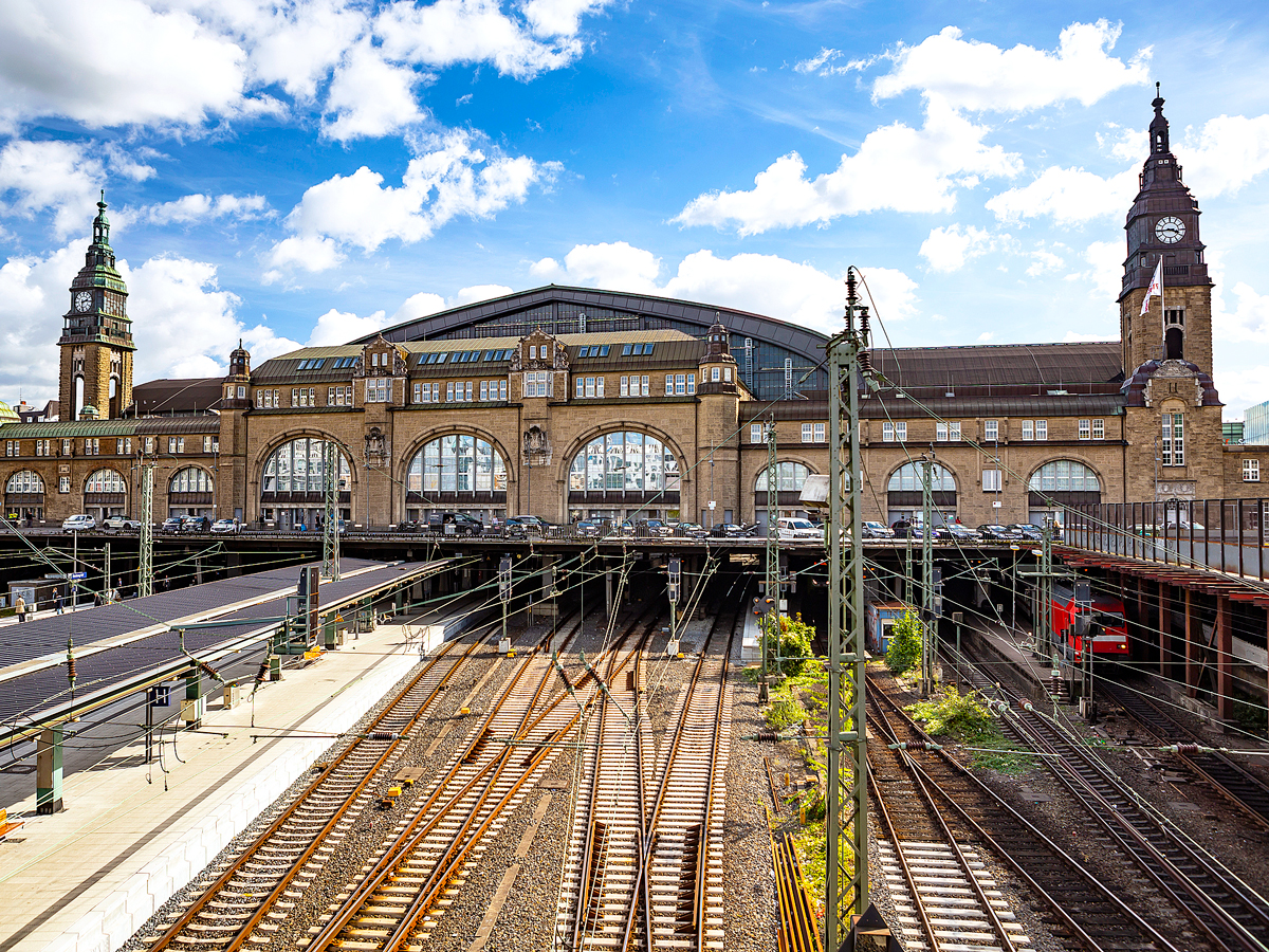
Hamburg Hauptbahnhof is Hamburg’s most important railway terminal. Some 550,000 passengers use the station every day, making it among Europe’s most transited railway hubs. Opened in 1906, the terminal replaced several smaller city stations. It features a grandiose train shed inspired by the Galerie des machines, which was a pavilion showcased at the 1899 world’s fair in Paris. Today, there are 14 platforms, including eight for main line services, four for S-Bahn rapid lines, and six for U-Bahn subway lines.
Occupying two floors above the station’s east and west exits is the Wandhalle retail mall. It’s home to dozens of gourmet and fast-food options, in addition to specialty stores. Art exhibitions and free concerts often take place around the mall.
Welcoming over 220 million passengers every year, Gare du Nord is one of the busiest train stations in Europe. A major gateway to the “City of Light” and northern France, it also serves as a hub for destinations in Belgium and the Netherlands. Plus, around 6.6 million passengers each year pass through the Eurostar Terminal, which connects to London via the Chunnel.
Not only a symbol of railway heritage, Gare du Nord is also a marvelous showcase of 19th-century architecture. Unveiled in 1846, the grandiose neoclassical facade is decorated with 23 sculptures by artists such as Charles Gumery and Jean-Joseph Perraud. They represent French and European cities once linked to Paris by the Chemin de Fer du Nord transport company.
Located beneath Madison Square Garden in midtown Manhattan, Penn Station (officially named Pennsylvania Station) sees a whopping 630,000 passenger entries and exits each day. This makes it the busiest station not only in the United States but also the entire Western Hemisphere.
Built and named after the Pennsylvania Railroad, the original station opened in 1910 and featured an ornate Beaux-Arts design. Reduced ridership numbers led to the station being decommissioned in 1963, after which the terminal was moved to its underground location. But in 2021, the stunning Moynihan Train Hall extension opened in a former post office building. In addition to welcoming passengers on Amtrak and Long Island Railroad (LIRR) services, the terminal features a food court with popular local eateries, various shops, and works from local artists.
6. Howrah Junction Railway Station – Kolkata, India
India boasts one of the world’s largest railway networks, which covers over 7,000 stations and transports some 25 million daily passengers. On the banks of the Hooghly River, Howrah Junction Railway Station — one of India’s oldest stations — serves as the main transport hub for eastern India.
The first public train departed from here in 1854 on the short route to the district of Hooghly. Today, the station handles over 900 passenger trains and a million passengers each day. Inside the striking red brick building are 23 platforms, 10 of which can fit trains with over 24 coaches. Railroad enthusiasts can delve into the history and heritage of the Indian railways at the station’s Railway Museum.
Japan is one of the world’s leaders when it comes to train travel. The country’s annual rail ridership stands at an incredible 22.6 billion passengers. At Yokohama Station alone, around 2.1 million passengers take overground and underground services every day. The original terminal was unveiled in 1872 near Sakuragicho and connected the city with Tokyo. The current station opened in 1928.
Like many modern railway terminals, Yokohama Station doubles as a retail and dining district. The multistory JOINUS center, which has around 300 stores, and the underground Yokohama Porta shopping mall are both directly accessible from the station. It’s also a gateway to Tokyo’s bustling tourist zones, including the futuristic waterfront neighborhood of Minatomirai.
Located in the Toshima Ward of Tokyo, Ikebukuro Station has a long and fascinating history. It was inaugurated in 1903 as part of a line that transported coal to Tokyo. From the 1930s onward, major developments popped up around the station, eventually turning it into a commercial hub. Most were department stores, such as Kikuya Department Store (currently Seibu Ikebukuro Main Store) and Tobu Department Store.
Today, Ikebukuro Station welcomes approximately 2.5 million passengers on a daily basis. They travel on eight lines serving the Tokyo metropolitan region and its major airports. At the west exit is Ikebukuro Nishi-guchi Park, a contemporary public plaza with an open-air theater, giant television screen, and fountains. Also nearby is the Tokyo Metropolitan Theatre, which stages dance, music, and other performing arts productions.
With cutting-edge designs and high-speed trains, Japan has mastered the art of train travel. That’s particularly evident at Shibuya Station. One of the biggest train stations in the world, it serves as the gateway to the Shibuya City financial district, one of Tokyo’s 23 wards. The bustling station handles an estimated 3 million passengers on a daily basis, many of whom arrive from the western and southern areas of Tokyo.
An enormous and sprawling complex, Shibuya Station consists of three aboveground and two underground terminals, plus a long underground pedestrian passage. Among the four main entrances is the Hachiko Gate, which features the statue of a famously loyal Akito dog named Hachiko, who reportedly waited at the station for his owner each day for nine years after his passing. Once exiting the station, passengers will find themselves amid the neon lights and skyscrapers of Shibuya Crossing, often referred to as Tokyo’s Times Square.
2. Chhatrapati Shivaji Maharaj Terminus – Mumbai, India
Chhatrapati Shivaji Maharaj Terminus, one of Mumbai’s standout architectural landmarks, is India’s busiest railway station. An estimated 3 million passengers use the station every day, traveling on both intercity and long-distance services. The station, which has a total of 18 platforms, has been featured in many movies, including 2008’s Slumdog Millionaire.
The building is a UNESCO World Heritage Site and was designed by British architect Frederick William Stevens. It combines classic Indian temple features with Victorian Italianate Gothic Revival styles. Crowning the central dome is Progress, a marble statue portraying a woman holding a torch and spoke wheel that represent knowledge and progress.
Situated in the Shinjuku City district of Tokyo, Shinjuku Station claims the top spot as the busiest railway station in the world. An incredible 3.6 million passengers use the terminal every day to board services operated by five different railway companies. To accommodate such high passenger numbers, the station is equipped with 200 entrances, 36 platforms, and 12 train lines.
Beyond being a transport terminal, the station connects to several shopping malls. Visitors will also find Tokyo attractions like Shinjuku Central Park and the famed Golden Gai nightlife district within a short walk of Shinjuku Station.
Advertisement
More from our network
Daily Passport is part of Inbox Studio, an email-first media company. *Indicates a third-party property.
7 Eerie Ghost Towns You Can Still Visit in the U.S.
By
Daily Passport Team
Read time: 7 minutes
October 25, 2023
Updated: October 25, 2023
7 Eerie Ghost Towns You Can Still Visit in the U.S.
History •October 25, 2023•Updated: October 25, 2023
By Daily Passport Team
Author
Daily Passport Team
Daily Passport writers have been seen in publications such as National Geographic, Food & Wine, CBC, Condé Nast Traveler, and Business Insider. They're passionate about uncovering unique destinations and sharing expert tips with curious travelers.
In the 19th century, miners looking to strike gold established settlements throughout the American West. Once bustling with people and businesses, these towns have long been abandoned, and their empty buildings and idle streets have become dusty time capsules of days gone by. Although many former mining boom towns have fallen into ruin, others are remarkably well-preserved. Below, discover the histories of seven of America’s most interesting ghost towns you can still visit today.
Now one of the best-preserved ghost towns in the U.S., Bodie was once a booming gold town near the Nevada border. Prospector William Bodey discovered gold there in 1859, and within a few years, the area had a mill, stores, and a continual influx of would-be miners. By the 1880s, the town’s population had swelled to 10,000 residents.
Although some families settled there, Bodie also had its fair share of saloons (in 1877, there were reported to be 65 of them), casinos, and brothels where the miners could spend their earnings. This would lead to one local preacher referring to the town as “a sea of sin.” It was not, unfortunately for the miners, a sea of gold — there was only so much to be found, and by the 1890s, the town was starting to fade. Several fires destroyed much of what was left.
What remained of the once-bustling Bodie became a state park in 1962. The dry desert air has helped to delay any further decay of the 200 buildings that are still standing. The park is open year-round to visitors, but its mountain elevation means it is accessible only by snow vehicles in the winter months. If you do visit, be warned: It is said there is a curse on anyone who takes any mementos away from Bodie, so you’re advised to leave everything as you find it.
Most of us tend to imagine ghost towns as dry, dusty, desert locales, but some had much greener surroundings. One such location is Garnet, Montana, which sits at 6,000 feet above sea level. Despite the fact that the town was named for a semi-precious ruby-colored stone, gold was what attracted people to set up claims in these remote mountains east of present-day Missoula. In fact, a lot of silver was discarded in the search for more valuable metal. When prospectors finally struck gold in 1862, a small town grew around the site.
Once the railroad came to a nearby town and allowed for easier movement of goods, the population started to boom, and by the 1880s, about 1,000 people called Garnet home. However, by 1905 that figure had shrunk to only about 200 residents. Fire destroyed many of the wooden buildings in 1912, and there were no attempts to rebuild, though the post office remained open until 1928.
The Bureau of Land Management has managed the site since 1970. Visitors can see the old jail (although records seem to show only one arrest), the town’s sole hotel, a saloon, a schoolhouse, and several homes. On the edge of Garnet, a walking trail passes through several mining areas, with explanations of the mining process. Those feeling adventurous can even spend the night here: Several cabins are open to overnight guests, but only in winter, so you’ll need to ski in and make do with propane and wood fires.
Although nowhere near as busy as it was in its heyday, Chloride, Arizona, stands out from the rest of the towns on this list as a sort of living ghost town. Among the abandoned buildings, there are still a handful of occupied residences and businesses, determined to keep going in this remote part of the Mojave Desert in northwest Arizona. The 2010 census listed its official population as 271. The town was named for the silver chloride mined there, although the area was also a source of lead, gold, zinc, and copper. Soon after it was settled in 1862, business boomed until World War II, when a lack of both workers and ore led to Chloride’s decline from its population peak of around 5,000 residents.
Today, Chloride has an eccentric funky vibe to it, largely due to the collection of junk art that is on display around town. After visiting the cemetery, jail house, former railroad station, and Arizona’s oldest continually operating post office, pick up a map so you can see all of the murals and sculptures that decorate the residents’ gardens. If you visit on weekends, mock gunfights are held in the main street. Before you go, be sure to stop by Digger Dave’s café and bar for a drink and a chance to admire the memorabilia that covers every inch of wall space.
Located just outside the boundaries of Death Valley National Park, Rhyolite, Nevada, is another example of a true boom-and-bust town. Gold ore was discovered in the area in 1904, and Rhyolite (named for the silica-rich volcanic rock in the area) was one of the mining camps established in the Bullfrog Mining District, about 120 miles northwest of Las Vegas. A significant amount was invested in the town — unlike Garnet, which had wooden huts, Rhyolite had multilevel concrete buildings, electricity, and a telephone system.
However, a financial panic in 1907 marked the start of the town’s decline. By 1916, the electricity was cut off, and by 1920, the former city of 6,000 was a ghost of its once-proud self, with just 14 residents.
Fortunately for visitors, the desert air and the solid structure of the buildings mean that the bulk of the town is still in good condition. Headstones in the nearby graveyard tell the stories of those who came here from far and wide. Also of interest are a bottle house, constructed entirely of empty beer bottles, and the ghostly sculptures at the Goldwell Open Air Museum on the edge of town.
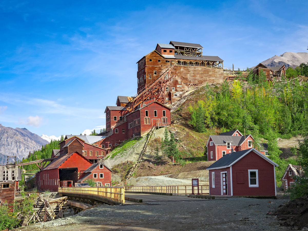
Situated in the heart of Alaska’s Wrangell-St. Elias National Park, America’s largest national park, Kennecott (or Kennicott, as it is sometimes spelled) is a National Historic Landmark. It is believed to be the best-preserved example of 20th-century copper mining.
Kennecott consisted of the copper mines and the nearby mill town where the mined ore was processed. Although the town itself was relatively small compared to other ghost towns (approximately 200 worked in the town and another 300 in the mines), Kennecott had its own hospital, store, skating rink, school, dairy, and other facilities. It is estimated that $200 million worth of copper was mined here between 1911 and 1938, making it the world’s richest copper mine.
Eventually, the Kennecott company opened more profitable mines in Chile, and the Alaska settlement wound down. By 1950, it was deserted, the buildings left to fall into decay. Now under management of the National Park Service, the town is being carefully restored so that visitors can continue to enjoy and learn for decades to come.
In addition to the remains of old buildings and the cemetery containing Frisco’s former residents, one notable attraction alone makes Frisco worth visiting. The town, located in Beaver County in southwest Utah, is dotted with dome-shaped stone kilns that resemble giant honeybee hives. These kilns were used to process silver ore, and have earned the town its place on the National Register of Historic Places. Silver was first discovered here in 1875, and in its heyday, Frisco was home to around 6,000 people.
The decline of Frisco came earlier than that of most other mining towns, largely due to a mine collapse in 1885. The resulting earthquake was felt 10 miles away, and the town never quite recovered afterward. A few attempts were made to reopen the mines, but by the 1920s, hardly anyone was left to work in them.
Visitors today can walk among the old buildings and kilns, but less is known about Frisco than the other ghost towns on this list, something that adds to the eerie atmosphere of this once-booming place in the Utah desert.
If you want to visit a ghost town that still has a few ghosts of its own, you might want to head to St. Elmo, Colorado, one of the best-preserved ghost towns in the West. Located at about 10,000 feet above sea level near the town of Buena Vista, St. Elmo was, like so many other ghost towns, created around the mines. In this case, both gold and silver were discovered in the 1870s, leading to the town’s official founding in 1880. The town was originally called Forest City, but since another Forest City already existed, residents were forced to choose a different name. One decided on St. Elmo, after a novel he was reading at the time.
With the railroad passing through, the town was a popular supply hub for nearby settlements and prospectors. However, with decreasing demand, the railroad closed in 1922. By 1930, St. Elmo’s once-prosperous population of 2,000 people had fallen to just seven, enough to run the hotel and store. Many claim to have seen the ghost of one of these last residents, Dirty Annie Stark. In fact, ghost hunters say that St. Elmo is one of the most haunted places in the entire state of Colorado. Visitors to the town, which is open from May through September, can explore the former homes and other buildings, including the general store.
Advertisement
More from our network
Daily Passport is part of Inbox Studio, an email-first media company. *Indicates a third-party property.
Daily Passport writers have been seen in publications such as National Geographic, Food & Wine, CBC, Condé Nast Traveler, and Business Insider. They're passionate about uncovering unique destinations and sharing expert tips with curious travelers.
The planet is home to 44 landlocked countries — ones entirely surrounded by land borders — but just three of them boast a far more unusual claim to fame. These countries are known as enclaves, and they aren’t just landlocked — they are located entirely within the territory of another state. Discover the fascinating histories of the world’s only three enclave countries.
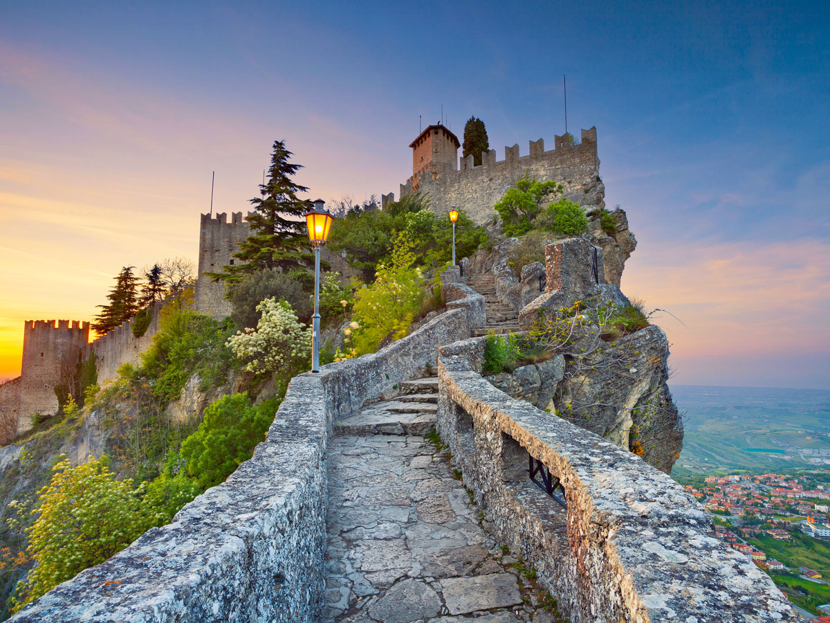
The Republic of San Marino was established in 301 CE, making it the world’s oldest-surviving constitutional republic. This microstate sits on the northeastern side of the Apennine Mountains in northern-central Italy, encompassed by the regions of Emilia-Romagna and Marche. Home to 33,000 permanent residents and covering an area of just 24 square miles, San Marino is also one of the smallest countries on the planet. The official language of this enclave is Italian.
According to legend, San Marino was founded when Saint Marinus (from whom the country derives its name) moved from Rab Island in present-day Croatia to Mount Titano and attracted a group of followers. While there, he performed a miracle and was given Mount Titano by its legal owner; he subsequently bequeathed it to the community upon his death. Historically under the political control of the Pope, San Marino first started to move toward independence in the 1300s. In 1463, the Pope awarded independence to the towns of Fiorentino, Montegiardino, and Serravalle in return for helping him defeat the Malatestas. These additions marked the country’s borders, which have been unchanged ever since.
Despite its miniature size, San Marino has huge touristic appeal. The namesake capital city sits atop Mount Titano and is inscribed on the UNESCO World Heritage List. It’s notable for its medieval walls, cobblestone streets, and Three Towers — defensive bastions dating back to the 1200s and perched on Mount Titano’s three peaks. Those wanting to delve into the state’s history and culture can do so at the Museo di Stato and Modern Art Gallery. Meanwhile, food and drink lovers will find gelaterias, pizzerias, seafood restaurants, and wine bars scattered around the country’s charming streets.
Lesotho, officially known as the Kingdom of Lesotho, is a mountainous country that’s entirely encircled by South Africa. Occupying an area of 11,720 square miles, this high-altitude territory was inhabited by a tribe of hunter-gatherers called the Khoisan beginning during the Neolithic Period. By around 500 CE, Bantu-speaking people arrived after a mass migration from West Africa and were later followed by Sotho-Tswana peoples. King Moshoeshoe I, the country’s first monarch, united the land that was then known as Basutoland under one rule in 1822. Just over two decades later, Moshoeshoe agreed to a treaty that made Basutoland a British protectorate.
A few more twists were to come before Basutoland eventually became Lesotho. It was annexed by the British-governed Cape Colony in 1871, but, after an inability to control revolts, the territory was returned directly to the British Crown in 1884. Full independence came in 1966, when Basutoland was renamed the Kingdom of Lesotho with King Moshoeshoe II as the head of state.
Today, Lesotho — nicknamed the “Kingdom in the Sky” — is famous for its breathtaking mountain landscapes. Visitors have no shortage of opportunities to hike and trek to mountaintops, across lush rolling pastures, and around national parks. At 11,424 feet, Thabana Ntlenyan is the highest point in the country and the tallest mountain in southern Africa.
Other interesting sights in the country include the ruined hideout of King Moshoeshoe I in Thaba Bosiu, near the capital city of Maseru, and Mount Qiloane, which is sacred in Basotho folklore. Visitors to Lesotho will also have the chance to indulge in cuisine which has been influenced by both Indigenous peoples and European settlers. The main staple is papa, a thick maize porridge, served with a bean, meat, or vegetable stew. To savor it like a true local, eat it by hand rather than with cutlery.
Located 140 miles south of San Marino is Vatican City. Officially called Vatican City State, this walled nation is entirely surrounded by the city of Rome. It is the headquarters of the Roman Catholic Church and the home of the Pope, who serves as both the bishop of Rome and leader of the Catholic Church. Occupying only 0.17 square miles, the Vatican is also the world’s smallest independent state.
For over a millennium, up until 1870, the Pope held sovereignty over the vast Papal States. They were made up of territories in central Italy and included the modern-day regions of Lazio, Umbria, Marche, and parts of Emilia-Romagna. This changed during the movement for Italian unification, when Rome came under the rule of Piedmont-led forces. The popes refused to accept the new political reality and retreated to live in the Apostolic Palace, the official papal residence. The situation was eventually resolved in 1929, when Benito Mussolini signed the Lateran Treaty on behalf of the Holy See and the Kingdom of Italy. It established the Vatican City as a city-state and gave special status to Catholicism in Italy.
In addition to being the center of Catholicism, Vatican City is a treasure trove of art and architectural masterpieces. Some of the most revered include the enormous St. Peter’s Basilica and the pillared Apolistic Palace, which houses the Vatican Museums. The Sistine Chapel hosts Michelangelo’s intricate ceiling frescoes, while elsewhere around the museums are works by Botticelli, Carvaggio, and Botecelli, among others. In 1984 the Vatican City became the first country to be inscribed on the UNESCO World Heritage List.
Advertisement
More from our network
Daily Passport is part of Inbox Studio, an email-first media company. *Indicates a third-party property.
8 of the World’s Tallest Buildings Throughout History
By
Daily Passport Team
Read time: 5 minutes
October 25, 2023
Updated: May 14, 2024
8 of the World’s Tallest Buildings Throughout History
Architecture •October 25, 2023•Updated: May 14, 2024
By Daily Passport Team
Author
Daily Passport Team
Daily Passport writers have been seen in publications such as National Geographic, Food & Wine, CBC, Condé Nast Traveler, and Business Insider. They're passionate about uncovering unique destinations and sharing expert tips with curious travelers.
Towering 2,717 feet above the modern metropolis of Dubai, the Burj Khalifa is currently the world’s tallest building. However, the record-breaking skyscraper has only held the title since 2010. Dozens of other phenomenal structures before it were once the tallest of their kind, from European cathedrals to ancient pyramids. Travel back in time to discover eight of the world’s tallest buildings throughout history.
Arguably the most famous tomb on the planet, the Great Pyramid of Giza was built by the Pharaoh Khufu as his final resting place. This limestone structure was the tallest building in the ancient world — no other civilization could match its prowess. It’s also the oldest pyramid on the Giza site; construction was finished in approximately 2560 BCE. The Great Pyramid was once filled with the treasures the Pharaoh needed for safe passage into the afterlife, but has long been plundered by grave robbers.
How the pyramids were built is one of history’s most persistent mysteries. Each stone block weighs over two tons, so moving them and layering them in such a geometric fashion was no small task. Archaeologists continue to investigate the ancient monument and regularly uncover new information about Egyptian society as a result.
The Great Pyramid retained its title as the world’s tallest structure for thousands of years, until Lincoln Cathedral in Lincoln, England, surpassed its height in 1311 CE. Medieval architects added a new central spire to the existing Norman church, which raised its total height to a reported 525 feet.
Made from wood and capped with lead, this new spire meant that Lincoln’s mighty cathedral could be seen from miles in any direction. Lincoln Cathedral remained the world’s tallest building until 1548, when a powerful gale took the central spire out. It was never replaced, and the remaining spires struggled to support their own weight, so the cathedral was ultimately redesigned in the early 19th century.
This picturesque city on the banks of the Rhine River (which marks the border between France and Germany) is home to a stunning Gothic-Romanesque cathedral, which became the world’s tallest building in 1647 after its ornate spire was completed. Novelist Victor Hugo described Strasbourg Cathedral as a “skillful combination of monumental size and delicateness.”
Constructed on the site of a Roman temple, Strasbourg Cathedral is considered one of the finest examples of Gothic architecture in Europe and is still the fourth-tallest church in the world. If you visit, make sure to see the fascinating astronomical clock and trek up to the 216.5-foot-tall viewing platform.
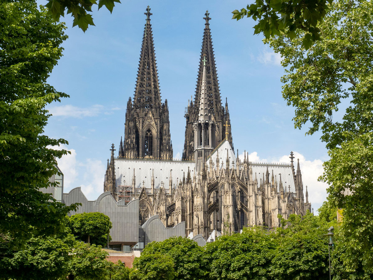
The late 19th century saw a number of churches compete for the title of the world’s tallest building, with each holding the record for a handful of years. The most well-known holder of the title (albeit briefly) was Cologne Cathedral.
The cathedral took over five centuries to complete, interrupted by wars, revolutions, and funding problems. When Cologne Cathedral was finally finished in 1880, it was the world’s tallest building for just four years — and the last religious structure to hold that title.
The central feature of D.C.’s National Mall, the Washington Monument reigned as the world’s tallest building in the late 1880s. Built to commemorate the first U.S. President, George Washington, the obelisk “stood in no one’s shadow” — just like the man himself.
Construction began in 1848 and was financed by a private group of Washington’s admirers, but money ran out and work was halted until after the Civil War. In 1876, construction restarted and was paid for with public funds. However, a different kind of stone had to be sourced — if you visit the monument today, you’ll notice a brown line about one-third of the way up that shows where the new (lesser-quality) stone was used. The Washington Monument is still the tallest building in D.C., as well as the world’s tallest masonry structure.
People from all over the world flocked to the 1889 world’s fair, held in Paris, where the star attraction was undoubtedly the event’s incredible main entrance — the new Eiffel Tower.
Designed by Gustave Eiffel, this wrought iron structure was not only striking to look at, but also a marvel of engineering. It utilized a lattice pattern to reach never-before-seen heights, catapulting the Eiffel Tower to the top of the tallest structure leaderboard. The original 1,024-foot structure was made even taller in 1957, when a television antenna was added. This took the Eiffel Tower’s total height to 1,063 feet.
In the 1930s, a skyscraper construction boom in New York City precipitated a new era of supertall structures. A number of projects in Manhattan raced to become the world’s tallest building, but it was the Art Deco Chrysler Building that finished first.
Architect William Van Alen found himself in competition with his former protégé, H. Craig Severance, who was working on 40 Wall Street at the same time. The two kept hearing of each other’s plans, making last-minute adjustments to their designs so their project would be taller. However, Van Alen beat Severance by adding a 180-foot stainless steel spire to the Chrysler Building, completing the project in 1930.
Shortly after the Chrysler Building opened, a new office building just a few blocks away in Midtown Manhattan snatched its crown — the Empire State Building. An internal steel frame supports the concrete exterior, which is also a prime example of Art Deco architecture. An antenna at the top, added in 1985, brings its total height to 1,454 feet.
The Empire State Building has 102 stories, with 1,872 stairs leading up to the Observation Deck at the top. Every year, there’s a competition to see who can run up them the fastest — but if you’d rather not do all that legwork, take one of the 73 elevators to the top instead.
Advertisement
More from our network
Daily Passport is part of Inbox Studio, an email-first media company. *Indicates a third-party property.
Why Is It Called a Baked Alaska? How 5 Foods Got Their Names
By
Jersey Griggs
Read time: 4 minutes
October 13, 2023
Updated: October 13, 2023
Why Is It Called a Baked Alaska? How 5 Foods Got Their Names
Culture •October 13, 2023•Updated: October 13, 2023
By Jersey Griggs
Author
Jersey Griggs
Jersey is a travel and lifestyle writer whose work has appeared in publications such as Condé Nast Traveler, Business Insider, and Bust. When she’s not exploring her adopted home state of Maine, she’s likely planning her next big trip.
Have you ever wondered why it’s called a baked Alaska and not a Baked New York? Or why Hollandaise sauce is named after Holland when it originated in France? When food is named after a specific place, the reasoning behind the name isn’t always straightforward. Read on to discover the unique origin stories of five popular foods named after places around the world.
Before it was renamed for America’s northernmost state, the baked Alaska was inspired by another cold-weather destination. The dessert’s first iteration was a similar French confection called omelette Norwegge, or Norway omelet. Consisting of layers of cake, ice cream, and toasted meringue, baked Alaska must be baked in the oven before being served, thus earning the other half of its appellation.
When French pastry chef Charles Ranhofer created a variation of omelette Norwegge at New York’s Delmonico’s in 1867, he originally called it “Alaska, Florida.” Ranhofer often inserted social and political commentary into the names of his desserts, and given the U.S.’s recent purchase of Alaska for $7.2 million dollars — a controversial subject at the time — the name of his new dessert was intended to draw attention. It was also a nod to the variation in temperatures between the cold ice cream (Alaska) and the toasted meringue (Florida). In the 1880s British journalist George Sala coined the term “baked Alaska,” and the name stuck.
Although baked beans are Boston’s signature dish, they weren’t invented in the Massachusetts capital. Similar versions can be found around the world, from French cassoulet to Portuguese feijoada. In the U.S., the dish dates back to pre-colonial America, when Native Americans cooked beans in earthenware pots. They later taught the technique to the Pilgrims, who borrowed the slow-cook method as a way to avoid working during the Sabbath.
However, Boston did put its own spin on the ubiquitous dish. During the 17th and 18th centuries, the port city was a key hub in the rum trade, with ships carrying molasses between the Caribbean, Boston, and Africa. Molasses was so plentiful that citizens put the sweet ingredient in their slow-cooked beans. It became such a popular dish that Boston became henceforth known as “Beantown” — a nickname that has stuck for centuries.
Sit down at any sushi restaurant these days, and you’ll be sure to find a California roll on the menu. The combination of imitation crab meat, avocado, and cucumber has proven popular since its creation. But before the 1960s, the ubiquitous sushi staple didn’t exist.
There are several competing theories about the roll’s creation. According to one, it was invented in the 1960s by Ichiro Mashita, a sushi chef who worked in Los Angeles’ Little Tokyo. Another gives credit to Hidekazu Tojo, who studied culinary arts in Japan and moved to Vancouver, British Columbia, in 1971. The chef took the principles of sushi from Japan and tweaked them slightly for Western palates, which were not used to raw fish. This also included flipping the sushi rice from the outside to the inside to mask the seaweed. Tojo says the name “California roll” came from the out-of-towners, many from Los Angeles, who gave the roll rave reviews that led to its surging popularity in the late 1970s.
Not only does Worcestershire Sauce bring loads of umami flavor to drinks, marinades, and salad dressings, but it is also the secret ingredient to beloved dishes like the Ceasar salad, shrimp cocktail, and bloody mary. But how did this fish-flavored, brown sauce become the powerhouse ingredient it is today?
Its origin story is an accidental one. After Lord Sandys of Worcester, England, sailed home from India in 1835, he missed Indian cuisine. He tasked two chemists, John Lea and William Perrins, to recreate a particular favorite sauce from his travels. Lea and Perrins concocted a mixture of fish and vegetables that smelled so terrible they had to move it to the basement — where they promptly forgot about it.
After two years of fermentation, the pair remembered the basement sauce and discovered that it had turned out quite tasty. They began to bottle the sauce up and named it after their hometown, Worcester, England. Though there are many other variations today, Lee & Perrins Worcestershire Sauce remains the original version of the famous sauce.
It might be named for a region in the Netherlands (aka Holland), but Hollandaise Sauce is very much a French creation. As one of the French mother sauces, Hollandaise is a variation of sauce Isigny, a rich butter and cream sauce named for a town in Normandy.
During World War I, food rationing changed French cuisine. Due to the government’s restriction of cream and milk and the cessation of butter production, sauce Isigny was no longer on the menu. Fortunately, France was able to import butter from Holland, and a new sauce was born. This new variation had no cream — only butter, eggs, and lemon. Today, the rich, buttery sauce is a key ingredient in eggs Benedict, the beloved brunch dish made with English muffins, Canadian bacon, and poached eggs.
Advertisement
More from our network
Daily Passport is part of Inbox Studio, an email-first media company. *Indicates a third-party property.
Outdoors •October 13, 2023•Updated: October 13, 2023
By Nicole Villeneuve
Author
Nicole Villeneuve
Nicole is a writer and researcher with over 15 years of experience seeking out arts, culture, and lifestyle stories in places like remote northern Quebec and the unforgettable streets of Amsterdam. Her work has also appeared in PureWow, Brit + Co, AUX TV, and CBC.
Coastlines hold a special allure, with their sheer natural beauty, dynamic ecosystems, and profound influence on human history and culture. These liminal spaces where the land meets the sea are forces of both tranquility and power. Often, they offer ample exploration and recreation opportunities — or at the very least, one of the best photo ops around. From the rugged beauty of Italy’s Amalfi Coast to the dramatic coastline of California’s breathtaking Big Sur, here are nine famous coastlines that are worth the trek.
Game of Thrones fans will recognize the Antrim Coast as one of the principal filming locations of the blockbuster show. Located in Northern Ireland, the captivating coastal region offers some of the most dramatic and varied countryside vistas in the country. In fact, the region is so stunning it’s been designated an official Area of Outstanding Natural Beauty.
The coast is best explored through the Causeway Coastal Route. Across about 120 undulating miles, visitors can explore the Carrick-a-Rede Rope Bridge, the historic Dunluce Castle perched on a cliff’s edge, and, most notably, Giant’s Causeway, famed for its tens of thousands of interlocking basalt columns that are the result of an ancient volcanic eruption.
This stunning slice of the Pacific Coast Highway — located between Carmel and San Simeon in central California — is famous for its dramatic cliffs, towering redwoods, hidden coves, and marvelous views of the Pacific Ocean. The beauty of Big Sur has intrigued adventurers, nature enthusiasts, and artists of all disciplines for generations. The list includes writers Jack Kerouac and Henry Miller, music legends the Beach Boys, and Australian-born landscape artist Francis McComas, who called the area the “greatest meeting of land and water in the world.”
Despite its popularity, Big Sur remains relatively isolated and sparsely populated due to environmental protections and the challenging access of its steep coastal mountain range and rugged coastline. Its breathtaking vistas remain a must-see, however, including spots such as Bixby Creek Bridge and McWay Falls, where the Santa Lucia Mountains meet the Pacific Ocean.
The Amalfi Coast, situated along the southern edge of Italy’s Sorrentine Peninsula, is famous for its steep limestone cliffs and coves, terraced vineyards, and lemon groves — all overlooking the crystal-clear waters of the Tyrrhenian Sea. Charming towns such as Positano, Ravello, and Sorrento dot the coast, each with distinct old-world and leisurely charm.
The region also boasts a rich historical heritage dating back to Roman times. Visitors can explore several historic sites, ranging from cathedrals to ancient ruins and significant works of art like the ceramics of Vietri. Outdoor enthusiasts can also tackle scenic hiking trails such as the Path of the Gods, while foodies have their pick of abundant lemon farms to visit. The Amalfi Coast was designated as a UNESCO World Heritage Site in 1997 for its topography, history, and culture.
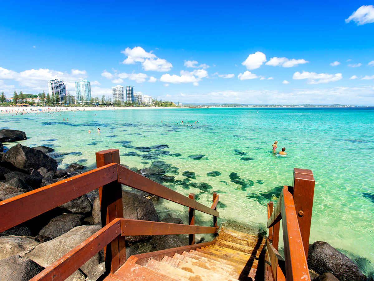
Coastlines don’t have to be all about natural beauty, and Australia’s Gold Coast is a prime example. Spanning over 40 miles along Queensland’s southeastern coastline — from Paradise Point along the Pacific Highway to Coolangatta at the New South Wales state border — Gold Coast is a bustling seaside city famous for its beautiful beaches, vibrant urban culture, and stunning skyline.
Iconic resort areas like Surfers Paradise, situated on its namesake beach, and Broadbeach, located on Kurrawa Beach, make the Gold Coast a mecca for surfers and sunbathers alike. The city is also home to world-class theme parks like Dreamworld and Warner Bros. Movie World, as well as the lush bushwalks of the Gold Coast Hinterland.
World-famous for its idyllic beaches, mild Mediterranean climate, and azure-blue waters (the inspiration for the French name of the region, Côte d’Azur), the French Riviera has been a magnet for artists, celebrities, and tourists for centuries. This coastline in the South of France coastline is home to glamorous cities like Cannes and Nice, the rolling hillsides of Provence, and the hilltop town of Eze, which feels straight out of a fairytale. It’s also home to fascinating historic sites such as the Monaco Opera and the Trophy of Augustus.
Spanning 125 miles along the southern coast of South Africa, the Garden Route extends from Mossel Bay in the Western Cape to Storms River in the Eastern Cape. This glorious stretch of coastline, hugging the Indian Ocean, is known for its natural beauty — from lush forests to sparkling lakes, rocky mountains, and pristine beaches. Visitors can enjoy the Garden Route in a variety of ways: road tripping with surreal coastal views, taking in the picturesque marinas of the enchanting town of Knysna, hiking the mountains of Plettenberg Bay, or daring to traverse the famous suspension bridge in Tsitsikamma National Park.
Also known as the Turkish Riviera, this famous coastline curving along Turkey’s southwest shore is as beautiful as the name suggests. The word turquoise comes from the French pierre tourques, meaning Turkish stone, which was first brought to Europe via Turkey. The coast has bays that indeed sparkle that distinct turquoise blue, particularly the otherworldly lagoon known as Ölü Deniz (Dead Sea). The coast is also rich in history and culture, with ancient Lycian tombs, rock-cut churches, and bustling bazaars.
The Great Ocean Road, spanning 150 miles along Australia’s southern coastline, is not only one of the country’s most popular tourist destinations, but also a historical marvel. Constructed by Australian soldiers returning from World War I between 1919 and 1932, this coastal highway offers visitors a unique opportunity to explore the stunning vistas along Australia’s southern edge, while also commemorating an important chapter in the nation’s history.
As it meanders alongside the mighty Southern Ocean, the Great Ocean Road showcases dramatic seaside cliffs, the lush Maits rainforests, and the towering 12 Apostles limestone rock formations of Port Campbell National Park.
The Cabot Trail is a 186-mile-long roadway that winds through Nova Scotia’s Cape Breton Highlands, offering awe-inspiring vistas of the Gulf of St. Lawrence and the Atlantic Ocean. Named in honor of explorer John Cabot, this breathtaking coastal area on the northern tip of the island also features old-growth Acadian forests, diverse wildlife, dramatic headlands and cliffs, and charming fishing villages rich with Celtic culture. The Cabot Trail is especially famous for its vibrant autumn foliage, making it a popular destination for those seeking picturesque coastal scenery in the maritime provinces of Canada.
Advertisement
More from our network
Daily Passport is part of Inbox Studio, an email-first media company. *Indicates a third-party property.