Architecture •November 8, 2023•Updated: November 8, 2023
By Daily Passport Team
Author
Daily Passport Team
Daily Passport writers have been seen in publications such as National Geographic, Food & Wine, CBC, Condé Nast Traveler, and Business Insider. They're passionate about uncovering unique destinations and sharing expert tips with curious travelers.
Humans have been building bridges since at least 4000 BCE, and since then, spans have become ever more ambitious. As some of the most challenging construction projects on the planet, they require careful consideration of gravity, tension, compression, and the landscape in which they are built. But when complete, bridges can become not only feats of engineering but also stunning architectural landmarks that stand the test of time. Here are seven of the world’s most unique bridges you can drive across.
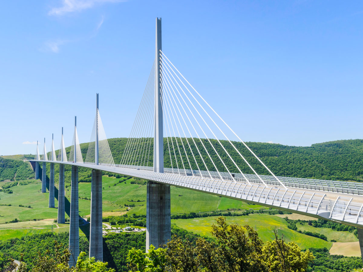
The Millau Viaduct is the tallest bridge not only in France but also Europe — the Eiffel Tower would fit comfortably beneath it. Reaching 1,130 feet tall, the cable-stayed bridge, which carries the A75 motorway that links the city of Clermont-Ferrand with the towns of Béziers and Narbonne, spans the Gorges du Tarn (Tarn Gorge) in southern France.
Its elegant and graceful design was the vision of British architect Sir Norman Foster, who collaborated with French engineer Michel Virlogeux to build the incredible structure from 2001 to 2004. The thin and slightly curved steel road bridge rests on just seven slim pillars, touching the ground in only nine places.
Authorities in Uruguay approached architect Rafael Viñoly to create a bridge as an alternative to ferry crossing over Laguna Garzón. The ferry could only transport vehicles across the water in calm weather during the day. But since the coastal lagoon on the Atlantic had a fragile ecosystem crucial for birdlife, a bridge couldn’t interfere.
After 15 months of construction and an investment of roughly $11 million, the bridge was unveiled in December 2015. But this is no ordinary structure. The bridge uses as few pillars as possible but most impressively, has a circular design to deter drivers from speeding. Pedestrians can also access the bridge to take in the extraordinary views and fish in the central pond.
Even sturdy bridges can still create white-knuckle experiences for drivers. The Confederation Bridge connects the Canadian provinces of Prince Edward Island and New Brunswick over the Northumberland Strait. This is the longest bridge spanning ice water in the world, sitting roughly 197 feet above sea level at its highest point.
For five months during the winter, the water flowing beneath the bridge is filled with chunks of ice. It’s so serious that the bridge’s piers have breakers to prevent any serious damage from ice crashing into them. As if that’s not enough, wind gusts are dangerously common due to the bridge’s location on open water. As a consequence, the Confederation Bridge website monitors and provides real-time wind conditions 24 hours a day.
The Tower Bridge crosses the River Thames beside the Tower of London. Designed by Sir Horace Jones and built between 1886 and 1894, the span remains one of London’s most distinctive and best-loved landmarks. The river is navigable upstream of this point, so any vessel that’s too tall to fit beneath it must notify bridge personnel in advance to get the bridge raised. If watercraft fail to report their expected time of passage, the crash is likely to be headline news. The now-commissioned Spanish oil tanker Monte Urquiola hit the bridge three times in the span of 10 years.
The Tower Bridge is what’s known as a bascule bridge (“bascule” is French for seesaw). Since 1976, oil and electricity have driven the bascules in place of steam. Visitors can see the engine rooms and machinery at work in the tower’s museum and walk across a glass floor while vehicles move below.
The Eshima Ohashi Bridge in Japan is considered one of the most daunting bridges to cross and is often referred to as the “Rollercoaster Bridge.” The bridge has some of the steepest gradients in the world, reaching 6.1% on one side and 5.1% on the other. But there’s a real purpose for these intense inclines.
The bridge is only a mile long and must reach a height of 144 feet so that ships can safely pass beneath it on Nakaumi lake. The bridge that Eshima Ohashi replaced had a more traditional drawbridge design, but when it was open, vehicles had to be halted in order to allow time for the boats to pass, leading to traffic jams.
It’s no secret that China has been beefing up its infrastructure in recent years. This means there are massive construction projects and numerous new bridges around the country that currently hold world records. One of these bridges is the Duge Beipanjiang Bridge, which currently holds the title of the world’s tallest bridge. Soaring nearly 1,855 feet high — the equivalent of a 200-story skyscraper — the bridge connects Guizhou and Yunnan provinces in southeastern China and crosses the Beipanjiang Grand Valley.
If you’re not from Louisiana, you probably first heard about the Lake Pontchartrain Causeway during Hurricane Katrina in August 2005, when it suffered serious damage. It was later repaired, and the bridge is now listed as a National Historic Civil Engineering Landmark by the American Historical Society.
Until 2016, the causeway was considered the longest bridge in the world until it was unseated by the Danyang-Kunshan Grand Bridge in China. After some contention between parties in the United States and China, Guinness created a new category to clarify any confusion. Today, the Lake Pontchartrain Causeway is the longest continuous bridge over water in the world — spanning 24 miles.
Advertisement
More from our network
Daily Passport is part of Inbox Studio, an email-first media company. *Indicates a third-party property.
The Best National Parks Around the World to Add to Your Bucket List
By
Daily Passport Team
Read time: 11 minutes
November 8, 2023
Updated: November 9, 2023
The Best National Parks Around the World to Add to Your Bucket List
Outdoors •November 8, 2023•Updated: November 9, 2023
By Daily Passport Team
Author
Daily Passport Team
Daily Passport writers have been seen in publications such as National Geographic, Food & Wine, CBC, Condé Nast Traveler, and Business Insider. They're passionate about uncovering unique destinations and sharing expert tips with curious travelers.
From the depths of Death Valley to the peaks of Denali, the U.S. has no shortage of incredible national parks. But as impressive as it is, America’s list only scratches the surface of the global park system. Don’t know where to start? Filled with ancient tombs, hidden temples, and underwater marine reserves, these 20 national parks in other countries are seriously worth adding to your bucket list.
Khao Sam Roi Yot National Park, located along the Gulf of Thailand, is famous for its limestone hills that reach as high as 900 feet above sea level. With a name that translates to “mountain with 300 peaks,” the park is open year-round, but it’s especially popular with birders in January and February, when 300 species of migratory birds flock to the park. However, the highlight for most visitors is likely the pilgrimage to Phraya Nakhon Cave, a spectacular limestone cavern that contains a Buddhist temple. The cave can be reached by boat or on foot, with guided trekking tours for visitors who are unfamiliar with the terrain.
Home to grizzly bears, moose, and elk, Jasper National Park is the biggest national park in the Canadian Rockies, providing visitors with 4,247 square miles of wilderness to explore. Located in western Alberta, the park offers rugged adventurers access to backcountry trails, mountain summits, alpine meadows, winding rivers, and pristine lakes. As a UNESCO World Heritage Site, Jasper draws roughly 2.5 million visitors a year. Skiing and snowshoeing are popular activities in winter, while summer visitors prefer camping and hiking.
Established in 1887, Tongariro is New Zealand’s oldest national park, drawing thrill-seekers to the area for over 100 years. With almost 200,000 acres of preserved land, the park is uniquely situated on three volcanoes, resulting in a dramatic landscape that has been formed over centuries. From ancient lava flows and steaming craters to emerald lakes, Tongariro’s geothermal activity makes it an incredibly diverse park. It’s also sought after by hikers who are brave enough to trek across the park’s active volcano — although checking Tongariro’s volcanic activity ahead of time is required.
Yakushima National Park – Japan
Photo credit: Sara Winter/ Shutterstock
An island preserve located on Yakushima Island at the southern end of Japan’s archipelago, Yakushima National Park is home to some of the country’s oldest trees. Ancient cedars that are over 1,000 years old can be found within the park, including Jomon Sugi — the oldest tree in Japan. Although reaching Jomon Sugi is an arduous hike that often takes up to 10 hours of trekking over boulders and up ladders, the journey through the temperate rainforest is sure to be memorable. If this type of hike sounds too strenuous, fear not. The park offers a network of trails for all skill levels, including stone-paved paths for easier trailblazing.
Most people are familiar with the famed Mount Kilimanjaro National Park in Tanzania, while neighboring Amboseli National Park remains lesser-known. Located beneath Mount Kilimanjaro just over the border in Kenya, Amboseli translates to “salty dust” in the Indigenous Maasai language, a nod to the park’s landscape. But in addition to its dusty plains, the park is home to wetlands, a savannah, woodlands, and a large, dried lakebed. The diverse ecosystem draws one of the largest populations of elephants in all of East Africa, with up to 1,600 elephants reported within the 150-square-mile park.
At a mere 29 square miles, Abisko National Park might be small, but its offerings are on a much larger scale. Located in the country’s northernmost province, Abisko is considered to be one of the best places in the world to see the elusive northern lights. With an Aurora Sky Station that can be accessed via chairlift, the park’s remote location and dark night skies provide the perfect viewing opportunity for aurora borealis. Since winter reigns supreme in this part of the world, Abisko offers plenty of other activities in colder months, including dog-sledding, snowshoeing, and even meeting reindeer at a nearby Sami village.
As Bolivia’s oldest national park, Sajama was established in 1939 as a way to protect the queñoa tree, which was being overforested. Today, the park stretches for 2,236 miles on a high Andean plateau at 13,100 feet. The vast plain provides the perfect habitat for alpacas and llamas, who can be seen roaming the landscape. Since the park is situated below a volcano, Sajama’s ecosystem provides plenty of exciting activities, such as soaking in natural hot springs, walking through geyser fields, and climbing the snow-capped volcano, Nevado Sajama. To avoid the rainy season, the best time of year to visit the park is between April and November.
For curious visitors, Uluru-Kata Tjuta National Park has plenty of geological and cultural activities for the taking. Originally established as protected land in 1950, the park encompasses Uluru Rock and Kata Tjuta Rock, which were once part of the Aboriginal Reserve. Since these incredible red-rock formations, which are estimated to be roughly 500 million years old, have been a part of Aṉangu culture for centuries, the park eventually recognized the Aboriginal people as the rocks’ original owners. As a result, visiting the park is shaped by this stewardship and is a fascinating lesson in Aṉangu culture. Visitors are invited to begin their trip at the Cultural Centre, where they can learn about the Aṉangu people, hear their stories, and understand how the land has been an integral part of their lives for 30,000 years.
This relatively young park was established in 1978, and with a network of trails that stretches for 155 miles, it provides some of the best hiking in Germany. Located in the Northern Alps near the Austrian border, the trails at Berchtesgaden National Park provide striking views of Bavaria at every turn. Visitors who trek through the park will often spy ibex, a species of a wild goat that roams the park’s mountainous landscape. Berchtesgaden is also known for Lake Königssee, a shockingly green alpine lake wedged between mountains where swimming is permitted.
Located within the confines of Garden Route National Park, Tsitsikamma National Park is a coastal stretch of protected land that runs along Plettenberg Bay. With access to the Indian Ocean, Tsitsikamma offers water lovers the opportunity to swim, snorkel, and kayak in the bay, or watch dolphins play in the breakers. Inland, Tsitsikamma is renowned for its forested hillsides, which contain indigenous plants, steep canyons, and suspension bridges that cross the water. The park is also a haven for animals and is home to Monkeyland Primate Sanctuary, which houses over 550 free-roaming primates.
Located in the landlocked province of Hubei, Shennongjia National Geopark is known for its mountainous terrain and thick forests. The forests are so replete with healthy trees that the park has been named a “natural oxygen bar,” which is a certified place in China that has fresh oxygen and plenty of negative ions. With acres of evergreens, deciduous hardwood trees, and waterways, Shennongjia is especially sought-after by nature lovers and anglers. And since the park limits its daily number of visitors, Shennongjia never feels overcrowded, even during peak season.
Stretching from the mountains of Sintra to the beaches in Cascais, Sintra-Cascais National Park offers a wide variety of activities for every type of traveler. From its rugged beaches tucked beneath soaring cliffs to its expansive mountains and hiking trails, outdoorsy visitors will find plenty to keep them busy. A mere 30 minutes from the capital of Lisbon, the park is also an ideal day-trip for sightseers looking to learn more about the history of the Iberian Peninsula. In addition to the Castle of the Moors, which dates back to Muslim rule during the eighth century, the Quinta da Regaleira is an ornate palace built in the early 20th century. Even more exciting, near the village of Rodizio, visitors can find fossilized dinosaur footprints embedded in limestone.
Consisting of 89 islands, Kornati National Park is an archipelago located off the coast of Croatia in the Adriatic Sea. Established as protected land in 1980, the park is mostly uninhabited, making it an expansive and exciting place for visitors. Often called a “nautical paradise,” many visitors to Kornati organize their own vessel to explore the islands and surrounding waters. Since the water is clean with good visibility, snorkeling and diving are popular activities in the protected bay on Levrnaka Island or around the small islet, Rasip Mali.
There’s no doubt that the Valley of the Flowers National Park is appropriately named. After monsoon season, the park’s meadows come alive with thousands of wildflowers. Located in the western Himalayas of India, the alpine flowers are exceptionally beautiful beneath the imposing, craggy mountains. The park is open from June until October, but the flowers are often at peak bloom in July and August. However, visiting the remote, high-altitude park is not for the faint of heart, as it requires a 12-hour drive, followed by a 10-mile hike on a steep mountain trail.
Gorkhi-Terelj National Park is often overlooked by tourists, but among locals, it’s one of the most popular parks to visit in Mongolia. Comprising 1,127 square miles of forest-covered mountains, rolling meadows, and pristine rivers, Gorkhi-Terelj is paradise for adventure enthusiasts. With activities that range from white-watering rafting to horseback riding to archery and dog-sledding, the park provides plenty of year-round fun. In addition to these active pursuits, Gorkhi-Terelj is popular for Turtle Rock, a natural granite formation that stands 80 feet tall and bears an incredible resemblance to a turtle.
Located in northwestern Wales, Snowdonia — or Yr Wyddfa as the locals refer to it — is both the largest and oldest of the country’s three national parks. Established in 1951, the park is named for Snowdon, the highest mountain in Britain at 3,560 feet above sea level. As a result, Snowdon is a large draw for trekkers who want to bag the high peak. Once that is accomplished, the park offers plenty of other beautiful and challenging summits, including Tryfan and Cader Idris. Snowdonia’s lakes, rivers, and coastline make it an ideal place for pursuing water sports, such as paddling, whitewater rafting, and even surfing. There are also plenty of historic sites to explore in the Welsh countryside, as the area has an abundance of castles built in the 12th and 13th centuries.
Bunaken Marine National Park was established in 1991 and is one of Indonesia’s first marine parks. It encompasses nearly 200,000 acres of land and sea, with 97% of the park underwater. Bunaken was created in order to protect marine biodiversity and to prevent harmful practices that could be detrimental to the region’s animal and plant life. Not only is the park a migratory route for protected sea creatures, but it’s also home to dozens of coral reefs. As such, it’s no surprise that Bunaken is an ideal location for divers, with 25 dive sites located throughout the park.
Grutas de Cacahuamilpha National Park in Guerrero, Mexico, is one of the largest cave systems in the world, with only 20 caves that have been explored out of the park’s estimated 90. With two rivers flowing through Cacahuamilpha, the cave system is considered to be a “live” cave, which means the groundwater causes the continuous formation of stalactites and stalagmites. With some cave salons as high as 265 feet tall, the cavern continues to enlarge over time, creating incredible formations such as “The Bottle,” which resembles a foamy beer. Since tours are the best way to see the cave, it’s best to reserve an English-led tour in advance.
Located atop Mount Nemrut at 6,909 feet above sea level is the archeological site of Nemrut Dağı National Park. Mysterious stone sculptures of ancient gods can be found here, erected by a former king as a burial tomb for himself. Constructed between 69 and 34 B.C., these ancient statues are not only massive, but their crumbling faces seem otherworldly atop the mountain. Mount Nemrut can be accessed by vehicle but is only open between May and October. Reaching the summit requires an uphill walk, so make sure you bring good hiking shoes!
Covering an astonishing 375,291 square miles of arctic landscape, the eponymous Greenland National Park is the largest national park in the world. Although the park is 100 times larger than Yellowstone National Park, it receives far fewer visitors annually — approximately 500 people or less. With the exception of the crew at the four weather stations, scientists and researchers, and the Sirius Patrol (a navy dog sled unit), the park is free of permanent human inhabitants, making it a vast and unspoiled place to explore. However, the park is home to numerous land and sea animals, including polar foxes, wolves, snow hares, polar bears, and humpback whales.
Advertisement
More from our network
Daily Passport is part of Inbox Studio, an email-first media company. *Indicates a third-party property.
8 Major Cities That Used to Be Called Something Else
By
Daily Passport Team
Read time: 6 minutes
November 2, 2023
Updated: November 2, 2023
8 Major Cities That Used to Be Called Something Else
History •November 2, 2023•Updated: November 2, 2023
By Daily Passport Team
Author
Daily Passport Team
Daily Passport writers have been seen in publications such as National Geographic, Food & Wine, CBC, Condé Nast Traveler, and Business Insider. They're passionate about uncovering unique destinations and sharing expert tips with curious travelers.
Have you visited Edo? What about Lutetia? Even if you haven’t heard of these names, there’s a good chance you might have stepped foot in these cities. While a name is perhaps the most obvious marker of a city’s identity, not all cities stick to their original monikers. Go back in time and discover what people from the past used to call eight major cities — and how they got the names we know them by today.
Tokyo, the heart of Japan and most populous city in the world, was first settled around 3000 BCE as a sleepy fishing village called Edo. Set on a sheltered bay, the village was a collection of humble homes made from bamboo and paper, and was originally named after the residents of the Kanto region, the Edo clan.
Peaceful Edo was thrust into the spotlight when the Tokugawa dynasty of shoguns made it their capital in 1603, and over the next few centuries it grew into a powerful urban center. The Meiji Restoration in 1868 brought further upheaval to the city when the Tokugawa shoguns were usurped and the Japanese Emperor was returned to power. The seat of the throne transferred from Kyoto to Edo, which was renamed “Tokyo,” meaning “Eastern Capital.”
From the “Romance Capital of the World” to the “City of Light,” Paris is known by many nicknames. But in Roman times, the actual name of the French capital was called Lutetia, a less-romantic Celtic name that roughly translated to “place near a swamp.” The area was originally settled by the Parisii tribe in the third millennium BCE.
When Julius Caesar took over Lutetia in 52 BCE, he transformed it into a Roman town complete with baths, an arena, and aqueducts (the ruins of which can still be seen in the city’s Latin Quarter). The city was renamed “Paris” after those original Celtic inhabitants, in the fourth century, after the fall of the Western Roman Empire.
When colonists from Europe first arrived in what is now Boston, Massachusetts, in 1630, they called this area Tremontaine or Trimount, after the hill with three peaks that originally dominated the peninsula on Massachusetts Bay. These hills were Mt. Vernon, Beacon Hill, and Pemberton Hill.
The city was officially renamed Boston (after the town of Boston in England) after a 1630 vote amongst the settlers. Not only did the old name disappear, so too did the hills: a massive land reclamation project in the 19th century meant that Boston’s three peaks were quarried away. Now, all that’s left of the undulating peninsula is the slightly elevated Beacon Hill neighborhood, plus streets named Mt. Vernon and Tremont.
The capital of Indonesia, Jakarta, has seen its fair share of folks fighting for naming privileges. The story begins in 1527, when the Sultan of Bantam (a nearby province) defeated Portuguese colonists at the mouth of the Ciliwung River. To celebrate his victory, he named the area Jayakarta, meaning “victorious deed.”
A century later, spice profiteers from the Dutch East India Company captured the city and established a trading post at this strategic location, calling it Batavia after a Germanic tribe then believed to be the ancestors of the Dutch people. The Netherlands grew rich from this colony, and the city remained under Dutch control until 1949, when Indonesia gained independence. Jakarta then became the city’s recognized name.
The city of Toronto was established by British general John Graves Simcoe in 1793, who thought the harborside location would be easy to defend from potential marauding Americans. Simcoe was known to dislike the area’s First Nations name, Tkaronto, a Mohawk word meaning “where there are trees standing in water.”
His superior, Lord Dorchester, proposed the settlement be named after himself, but Simcoe didn’t think much of him, either. So, Simcoe called his new town York in honor of the Duke of York. But Simcoe’s choice didn’t last long. When the city was incorporated in 1834, the government opted to christen it Toronto, a variation of the original Mohawk name, as it had a “musical sound.”
Norway’s twinkling capital in the fjords, Oslo, is centered around one major landmark: the Akershus Fortress. This old castle was built by King Haakon V in the 14th century. However, in 1624, a massive fire destroyed swathes of the city. The reigning King of Norway, Christian IV, decided that the city would be rebuilt below the walls of the Akershus, and took the opportunity to name the construction project after himself — thus, Oslo (which translates to “the meadow beneath the hill”) became “Christiania.”
In 1877, the spelling was changed to “Kristiania” to make it more appropriate for the Norwegian language, but the city’s residents were slow on the uptake. After Norway became fully independent of Sweden in 1905, the city’s old name was increasingly used to bolster national pride, and became its official moniker in 1925.
In Harare, Zimbabwe, the ruins of ancient African civilizations rub shoulders with towering skyscrapers. When colonists from Britain led by Cecil Rhodes first founded a settlement here in 1890, they called it “Fort Salisbury” — not after the English cathedral city near Stonehenge, but for the Prime Minister at the time, who also happened to be the Marquess of Salisbury.
The military settlement ultimately became the capital of the Rhodesia colony until, in 1980, Zimbabwe won its independence from Britain. On the independent nation’s second anniversary, they renamed their growing capital to “Harare” — a powerful name, honoring a 19th-century Shona chief.
Many of California’s place names are a reminder of the West Coast’s Mexican past, with Los Angeles, San Diego, and San Francisco all deriving from the Spanish language. But did you know that San Francisco is not the Golden Gate City’s original name? This bayside settlement was first called Yerba Buena (“good herb”) by Mexican pioneers in the 18th century, named so for a fragrant herb of the same name that grew in abundance there.
After the U.S. took possession of the city in the Mexican-American War, the city was renamed San Francisco in 1847, because a mission dedicated to St. Francis was one of the first buildings by the bay. Now, all that remains of Yerba Buena is a city district famous for its food, art, and excellent museums.
Advertisement
More from our network
Daily Passport is part of Inbox Studio, an email-first media company. *Indicates a third-party property.
Why These 5 Far-Flung Landmarks Are Worth the Trek
By
Cynthia Barnes
Read time: 5 minutes
November 2, 2023
Updated: November 2, 2023
Why These 5 Far-Flung Landmarks Are Worth the Trek
Culture •November 2, 2023•Updated: November 2, 2023
By Cynthia Barnes
Author
Cynthia Barnes
Cynthia kicked around the world for a while before landing in Colorado. Her work has appeared in Food & Wine, the Boston Globe, and National Geographic, among others. She loves dives — both scuba and bars — baseball, the Oxford comma, and live music.
While many iconic landmarks (like the Statue of Liberty, the Great Pyramids, Niagara Falls, or Rome’s Colosseum) are relatively easy to visit, there are other places around the globe that are undeniably special, but require some extra effort to reach. From a stunning mountainside monastery to a legendary 15th-century citadel, here are five bucket-list landmarks around the world that are worth the trek.
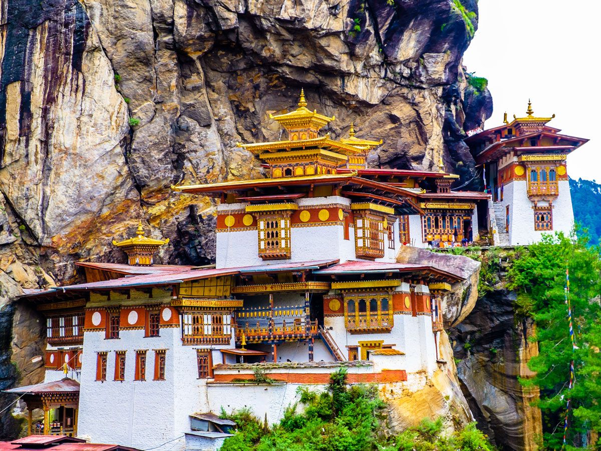
Legend has it that, in the eighth century, Buddhist master Guru Rinpoche arrived at this breathtaking mountainside locale overlooking Bhutan’s Paro Valley by flying in on the back of a tigress. Without a flying tigress, visitors to the Tiger’s Nest Monastery today will need to fly into Paro — the only international airport in the Kingdom of Bhutan. From Paro, it’s about a 25-minute drive to the place where you’ll begin your four-mile hike to the monastery. Guru Rinpoche, a central figure in Buddhism, meditated here for three years, three months, three days, and three hours to subdue the demons at the site — however, your trek should only take about two hours, including a steep path that takes you up to 10,000 feet.
The monastery is both the holiest Buddhist site and the most-visited attraction in Bhutan, so it’s recommended to leave early (around 6 a.m.) and bring pants or a long skirt, as visitors will not be admitted wearing shorts. Photography and phones inside the temples are not permitted, but you can get a spectacular picture at the famous viewpoint and then walk down 780 steps to the monastery itself.
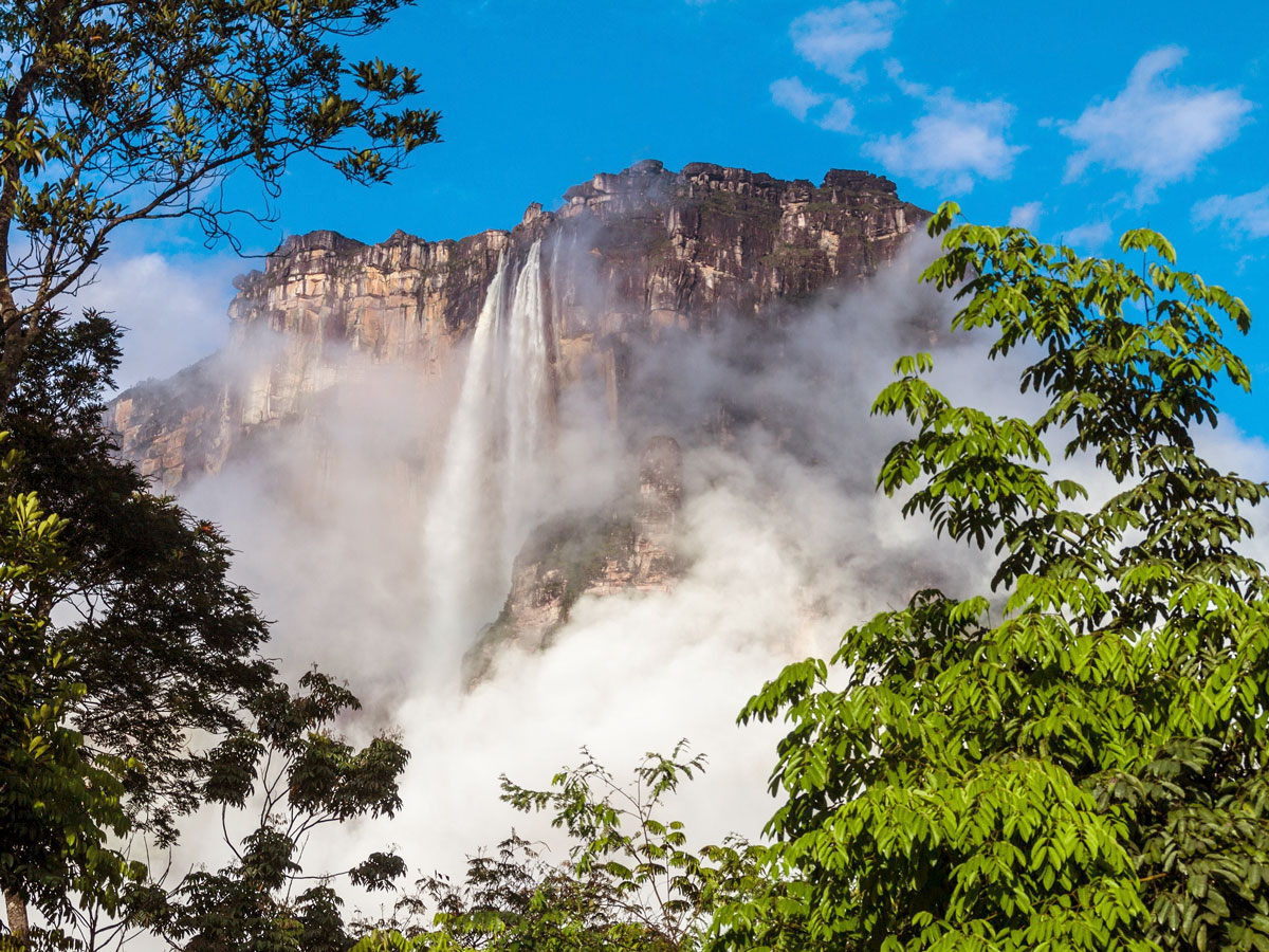
Hidden in the dense jungle of Venezuela’s Canaima National Park is the world’s highest uninterrupted waterfall, the 3,212-foot Angel Falls. But it takes considerable effort to get there. It’s a two-day journey once you reach the town of Canaima, after flying on a small plane from Puerto Ordaz, Caracas, or Ciudad Bolívar. The following morning, you’ll board a curiara (small boat) for the four-hour ride up the Rio Carrao to a staging point. From there, you’ll hike to the base of the falls and camp overnight, sleeping in hammocks before setting off on your return to Canaima.
A travel advisory to Venezuela has reduced the number of visitors, and it’s recommended to choose a reputable tour operator wisely and remember to carry cash, as Canaima does not have ATMs. Your reward for the journey will be a once-in-a-lifetime adventure to the world’s highest falls, surrounded by stunning landscapes filled with the sound of birds and monkeys who call the jungle canopy home.
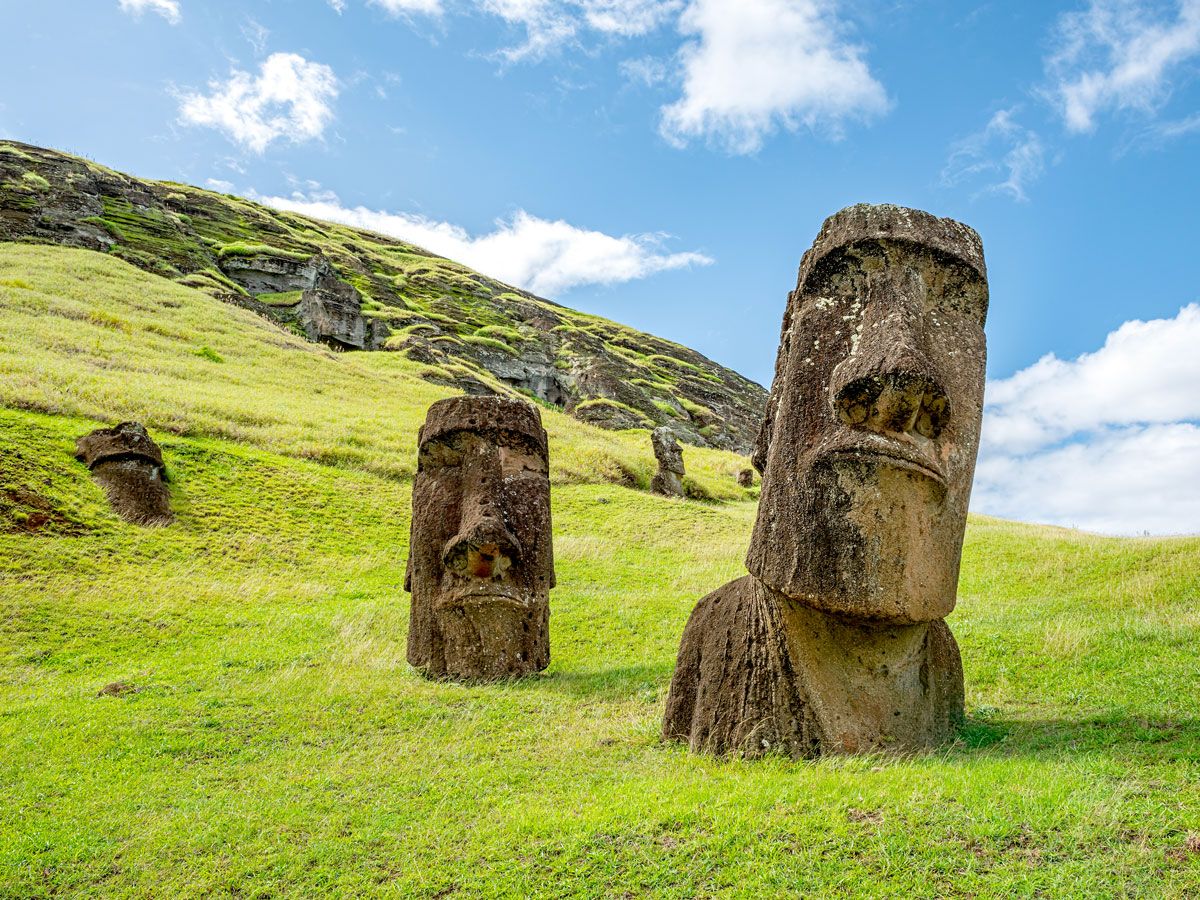
You’ll need a lot more than a long weekend to visit Easter Island’s noble moai, the enormous monolithic stone statues that have made this one of the world’s most instantly recognizable landmarks. One of the most remote inhabited places on the planet, Easter Island is located in the middle of the Pacific Ocean, more than 2,000 miles off the western coast of South America. The Rapa Nui peoples — who carved these immense figures from volcanic stone around 1400 to 1600 CE — considered them sacred, and it is still forbidden to lay hands upon the monuments.
Around a thousand moai are scattered across the island half-buried in the earth. Each of the giant hand-carved stone statues weighs around 14 tons and stands 13 feet tall on average, and their purpose has also been the subject of much debate. To reach them, you can take a luxurious cruise — Seabourn and Silversea offer sailings — or take a 5.5-hour flight from Santiago.
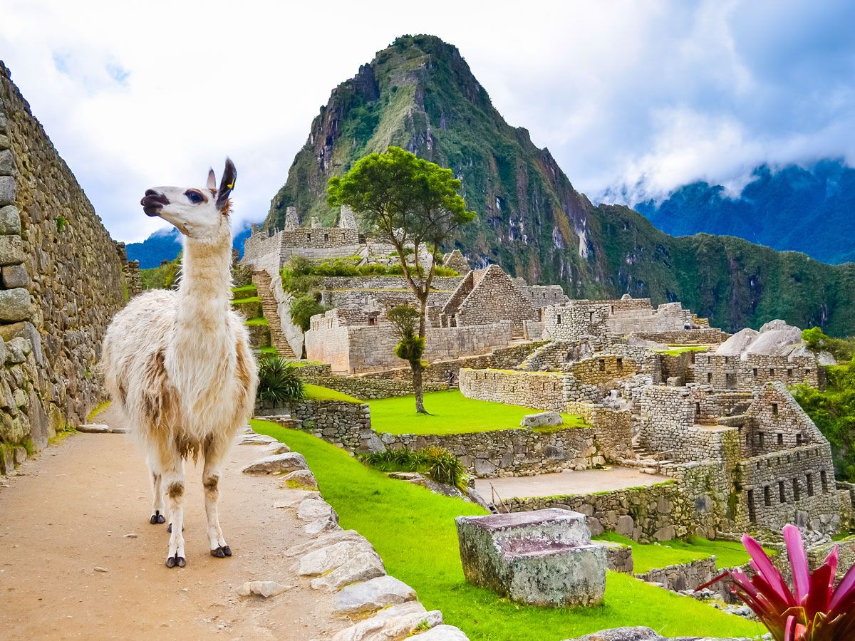
There are a number of ways to make the journey to legendary Machu Picchu, the majestic 15th-century citadel constructed by the Inca peoples high in the Andes mountains. Topping seemingly every adventure traveler’s “must-see” list, Machu Picchu is a glory of archaeology in a stunning natural setting. The UNESCO World Heritage Site was built at the height of Incan influence, when their empire stretched from northern Ecuador to central Chile and ruled over 12 million inhabitants. Discovered by the outside world in 1911, Machu Picchu has 200 ceremonial, religious, and astronomical structures that are crisscrossed by stone terraces along with agricultural areas.
Intrepid travelers can hike the iconic Inca Trail over a period of four days, while others may choose a luxury train journey. The low-cost local train is not available for foreigners, but bus service is offered from Aguas Calientes. With thermal baths, lively restaurants, and a great crafts market, the town and surrounding area is worth a few days in its own right.
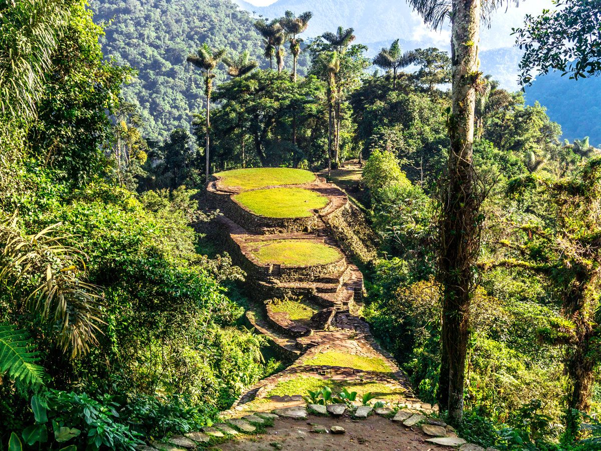
Hundreds of years before the construction of Machu Picchu, the people of the Tairona civilization built their own settlements deep in the jungle of the Sierra Nevada Mountains, in what is now Colombia. The largest of these, located at 19,000 feet above sea level, was hidden by thick jungle for over 400 years.
This magnificent real-life “lost city” was only rediscovered in 1972 by a group of local treasure hunters, who found a series of stone steps rising up a mountainside and followed them to the abandoned city. To date, only a sliver of the site has been excavated, finding mud and stone terraces and excavations along with gold and pottery. To experience Ciudad Perdida, visitors must make a strenuous 30-mile round-trip trek along the Buritaca River, braving steamy jungle and many mosquitoes. Facilities are extremely basic, although camps and snack shacks are starting to spring up along the route, and the payoff of exploring this mystical jungle-surrounded slice of history is well-worth the effort.
Advertisement
More from our network
Daily Passport is part of Inbox Studio, an email-first media company. *Indicates a third-party property.
Culture •November 2, 2023•Updated: November 2, 2023
By Nicole Villeneuve
Author
Nicole Villeneuve
Nicole is a writer and researcher with over 15 years of experience seeking out arts, culture, and lifestyle stories in places like remote northern Quebec and the unforgettable streets of Amsterdam. Her work has also appeared in PureWow, Brit + Co, AUX TV, and CBC.
In the late 19th and early 20th centuries, cities in the Midwest became some of the largest population centers in the U.S. — buoyed by their strategic locations and contributions to auto manufacturing, steel production, and transportation. As hubs of commerce and innovation, they attracted people from around the country. But in the later half of the 20th century, these cities — key points in what’s known as America’s “Rust Belt” — faced the challenges of deindustrialization, technological advances, globalization, and population decline. Today, many of the places that were once the heart of American manufacturing and industry have diversified their economies and revitalized their urban spaces. Discover the fascinating histories of five once-thriving Rust Belt cities and why they’re well worth visiting today.
For much of the first half of the 20th century, Detroit flourished as a hotbed of auto manufacturing. The “Big Three” car companies — General Motors, Ford, and Chrysler — were all based in Detroit’s metropolitan area, and the city saw an influx of people from all over the country in pursuit of well-paying jobs. By 1950, the population swelled to a peak of 1.8 million residents, making it the fifth-largest city in the country. By the mid-20th century, due mainly to economic and technological shifts, Motor City started on a path of population decline. In 2013, Detroit filed for bankruptcy, becoming the largest American city to ever do so.
Fortunately, modern-day redevelopment of the city’s once-beautiful buildings is well underway. Cultural institutions such as the Motown Museum and Detroit Institute of Arts are thriving, neighborhoods like Eastern Market are artistic and culinary hubs, and green spaces like the Riverwalk and Belle Isle Park in the city’s southeast are undergoing revitalization.
Buffalo earned its “Queen City” nickname in the mid-1800s, when it was one of the most prosperous cities in the Great Lakes region. After the completion of the Erie Canal in 1825, Buffalo became a pivotal hub for transporting goods from Chicago to New York City and onwards via the Atlantic Ocean. Other industries emerged to take advantage of the products that passed through — the grain industry became a key component of the city’s growth, and Buffalo’s outer harbor was home to manufacturers of steel and other materials that contributed to the city’s industrial prominence.
By 1900, Buffalo was the eighth-largest city in the United States and the sixth-busiest water port in the world. Its population had grown to over 350,000 people and would reach its peak of 580,000 in 1950 — about half of what it is now. When the St. Lawrence Seaway opened in 1959, the use of the Erie Canal greatly diminished. Like many American Rust Belt cities, this also coincided with postwar suburbanization, increased access to cars, and manufacturing automation — depleting the city of its finances, economic prowess, and population.
But Buffalo has embarked on a path of revitalization, as the state of New York is channeling substantial investments into the city. At the grassroots level, entrepreneurs are venturing into small businesses such as breweries, restaurants, and housing projects. This has turned previously overlooked neighborhoods into vibrant pockets that are fueling the city’s revival.
In the late 19th and early 20th centuries, steel mills, coal mines, automotive factories, and John D. Rockefeller’s Standard Oil refineries contributed to Cleveland’s economic prosperity. The city’s advantageous location on the shores of Lake Erie facilitated transportation and trade, turning it into a bustling manufacturing center.
But by the 1960s, Cleveland’s industry was in decline, feeling the effects of inflation as well as international competition. The city also experienced tensions and violence among its diversifying population, which led to a suburban exodus. And in 1969, oil on the Cuyahoga River caught fire, helping to solidify Cleveland’s unfortunate nickname of “Mistake on the Lake.”
Although the city’s population is still only a fraction of its peak of 914,000 people, Cleveland’s fortunes have been changing in recent years. While manufacturing is still an important industry in the city, Cleveland has also diversified its economy, focusing on sectors like healthcare, technology, and higher education — with the Cleveland Clinic, Case Western Reserve University, and University Hospitals all prominent institutions in the city. Meanwhile, investments in waterfront redevelopment, cultural attractions like the Rock and Roll Hall of Fame, and a growing culinary scene have given the city new vitality — transforming Cleveland from a classic Rust Belt city to a multifaceted urban center.
Situated along the Mississippi River, St. Louis, Missouri, became an important transportation and trade center in the 19th century. The “Gateway” city was also an early part of the U.S. automotive industry, and throughout the early 20th century, St. Louis also excelled in a range of other industries, including brewing and aerospace. But like many urban areas at the time, St. Louis experienced financial hardships during the Great Depression.
While the city’s industrial output ramped back up with ammunition and vehicle production during World War II, pushing the population over 850,000 by 1950, St. Louis would face several decades of hard times ahead. Urban planning during this era — including interstate highways that cut through several neighborhoods — sent the city population into the suburbs. By 1980, the St. Louis’ population had fallen to about 450,000.
In recent years though, St. Louis has embarked on a journey of reinvention. Finance and technology now fuel the city’s economy, and the city’s fascinating cultural attractions — such as the Gateway Arch, the St. Louis Art Museum, and Forest Park — continue to attract visitors and locals alike. St. Louis’s unique neighborhoods and vibrant culinary scene — notably its barbecue culture — add to the city’s renewed charm.
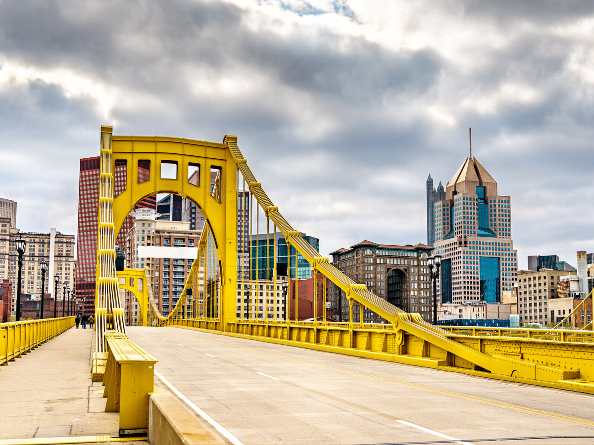
Steel mills were once a defining part of Pittsburgh’s landscape. Throughout the late 19th and early 20th centuries, the “Steel City” stood as an American industrial powerhouse fueled by major companies like U.S. Steel and Carnegie Steel, built by infamous American industrialist Andrew Carnegie. Pittsburgh’s population swelled, and by 1950, it reached its peak at over 670,000 people — making it the 12th largest city in the country at the time.
During the 1970s, however, the steel industry in the U.S. started to crash. The economic downturn of the 1970s and 1980s, as well as increased global competition, began to take a toll on Pittsburgh’s primary industry. As the steel mills closed and jobs were lost, the city’s population steadily declined.
In recent years, Pittsburgh has successfully transformed itself into a hub for technology and medicine, and its economy now revolves around robotics, artificial intelligence, and healthcare. Stadiums for several successful and popular major-league sports teams now take the place of steel mills, including the MLB’s Pittsburgh Pirates, the NHL’s Pittsburgh Penguins, and the NFL’s Pittsburgh Steelers. The city’s innovative spirit, along with its investments in clean energy and environmental restoration, has allowed Pittsburgh to rise from the ashes of deindustrialization.
Advertisement
More from our network
Daily Passport is part of Inbox Studio, an email-first media company. *Indicates a third-party property.
Get Lost in These 5 Spellbinding Secret Gardens Around the World
By
Fiona Mokry
Read time: 4 minutes
November 2, 2023
Updated: November 2, 2023
Get Lost in These 5 Spellbinding Secret Gardens Around the World
Outdoors •November 2, 2023•Updated: November 2, 2023
By Fiona Mokry
Author
Fiona Mokry
Fiona has spent her career exploring the world and working in the travel industry, turning her lifelong passion into a profession. From planning custom trips to sharing stories as a travel writer for publications such as The Discoverer, she’s all about helping others experience the world in a deeper, more meaningful way.
Whether you want to walk along the majestic fjords of Norway, forge deep into Mexico’s rainforests, or climb one of the world’s tallest mountains, there are countless opportunities to get out and enjoy the beautiful bounty of nature. But what about the places few travelers have ever heard of? From a historic moss-covered temple in Kyoto, Japan, to the magnificent estate that inspired a famous novel, here are five of the world’s most enchanting secret gardens to discover on your travels.
British poet and surrealist Edward Frank Willis James was the mastermind behind this garden intertwining the natural and modern world in the depths of Mexico’s Sierra Madre mountains. Las Pozas requires some effort to reach but is more than worth the journey to leave the tourist track in the dust. Between 1949 and 1984, James spent millions on the creation of the garden’s emblematic concrete structures, which are now deeply rooted in the dense rainforest surrounding Xilitla.
Today, visitors to this garden and art museum can cross a bridge and pass a rushing river before entering the eccentric world of the writer — all 80 acres of its pristine wilderness, moss-covered sculptures, and whimsical structures with names like The House With a Roof Like a Whale, The Staircase to Heaven, and The House of Three Floors That Will In Fact Have Five or Four or Six. If you’re looking to travel to another dimension, this may be as close as it gets.
Hidden amid the grounds of Great Maytham Hall, this real-life garden inspired Frances Hodgson Burnett to write her classic novel A Secret Garden in 1911 (which was later adapted into a 1993 film). Burnett was the first tenant to live at the estate and discovered its walled garden filled with blossoming roses. Today, the garden is impeccably groomed with blooming displays of bluebells, daffodils, iris, and wisteria climbing the charming brick — along with the distinctive wrought-iron gate described in the book. The serene and secret setting has made this garden a sought-after wedding venue for couples around England.
As this is the northernmost botanical garden in the world, tourists only have a small window to visit this alpine garden before it disappears under a blanket of snow for much of the year. From late spring to early fall, you can find a carpet of cold-weather plants alongside tropical blooms clumped tightly together amongst rocky beds in northern Norway’s Arctic-Alpine Botanic Garden. Follow the gravel trails that wrap around large rocks to find pockets of color — from Tibetan poppies to yellow cushion flowers, Falkland slippers, and many other plants from around the world. The bonus is undoubtedly the breathtaking views of the mountains and fjords surrounding this Arctic city from the garden’s elevated position.
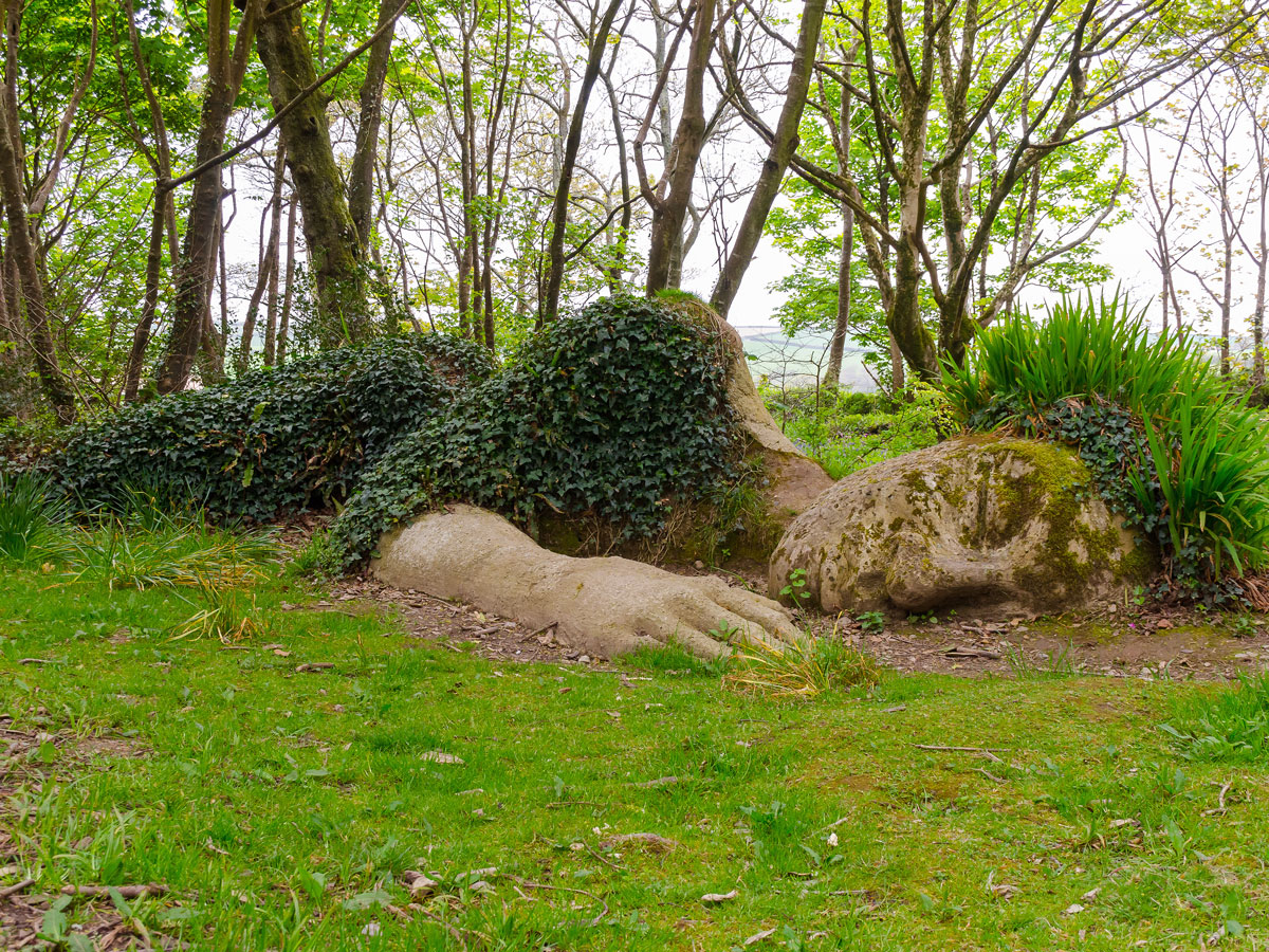
The lush, expansive, and mysterious grounds of the Lost Gardens of Heligan date back to the 1800s and reached their prime at the end of the century. However, after World War I, the gardens fell into disarray, and it wasn’t until 1990 that these 200 acres were revived as one of Europe’s largest garden restoration projects.
A present-day walk through these lost gardens is a true treat for any nature lover, plant enthusiast, or even history buff — much of the brick wall and some of the structures are original. Sculptures, water features, ancient rhododendrons, flower and vegetable gardens, subtropical tree gardens, bamboo tunnels, and a suspended bridge are a few of the spectacular features you’ll find here.
As one of Kyoto’s many UNESCO World Heritage Sites, the moss garden at Kokedera Temple (also known as the Saiho-ji Temple or Moss Temple) isn’t so much a secret anymore. However, it certainly feels like you’ve found a special hidden place when you set eyes on the acres of glorious emerald carpets found here. The rolling terrain, wooden bridges, stone steps, and human-made islands are all covered in 120 varieties of moss. The serenity is sustained by the limited number of guests allowed to enter each day (pro tip: make a reservation in advance). Besides appreciating the pure tranquility of this temple, visitors can also partake in activities such as sutra writing, chanting, or sitting meditation.
Advertisement
More from our network
Daily Passport is part of Inbox Studio, an email-first media company. *Indicates a third-party property.
5 Interesting Presidential Birthplaces Any History Buff Should Visit
By
Jersey Griggs
Read time: 4 minutes
November 1, 2023
Updated: January 9, 2025
5 Interesting Presidential Birthplaces Any History Buff Should Visit
History •November 1, 2023•Updated: January 9, 2025
By Jersey Griggs
Author
Jersey Griggs
Jersey is a travel and lifestyle writer whose work has appeared in publications such as Condé Nast Traveler, Business Insider, and Bust. When she’s not exploring her adopted home state of Maine, she’s likely planning her next big trip.
As one of the most powerful people in the world, the President of the United States is a figure of fascination for many. Perhaps this is why so many seek out a visit to the various birthplaces of our nation’s 46 Presidents. Offering remarkable historical insights, they are places to honor, memorialize, and teach the public about the leaders who shaped the nation. From humble cabins to impressive estates, here are five presidential birthplaces that are well worth the visit.
George Washington Birthplace National Monument – Colonial Beach, Virginia
Located in the Northern Neck region of Virginia, this 550-acre park is where the nation’s first President was born in 1732. The former home of George Washington’s family for seven generations, the property — situated between the Potomac and Rappahannock Rivers — was turned into the George Washington Birthplace National Monument nearly 200 years after the first commander-in-chief was born.
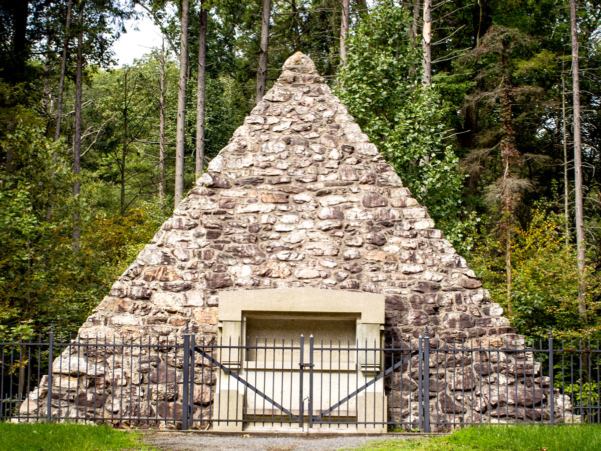
When James Buchanan was born in 1791, Cove Gap was considered the unofficial gateway to the West. Located on the border of the Allegheny Mountains, the town was the final mercantile stop for westward settlers venturing into the unfamiliar Pennsylvania frontier. At the time, Buchanan’s father ran the town’s trading post, which was also home to cabins, a store, an orchard, and stables.
Today, it is the Buchanan Birthplace State Park, which covers 18.5 acres of forested mountains and the Buck Run, a river popular with trout anglers. The park’s 31-foot-tall pyramid marks the spot where Buchanan’s childhood cabin stood, the very same location where the 15th President came into this world.
Theodore Roosevelt Birthplace National Historic Site – New York, New York
Located in the Flatiron District of Manhattan, Theodore Roosevelt’s birthplace was where the future 26th U.S. President spent most of his childhood days. Born in 1858, young Teddy suffered from nearsightedness, asthma, and frequent illness, which caused him to stay indoors for the first decade of his life. It wasn’t until the age of 12, two years before his family departed the New York brownstone, that his health turned for the better.
The building that now stands at 28 E. 20th St is a replica of the 26th President’s boyhood home, built by the Women’s Roosevelt Memorial Association a few years after the President’s death in 1919. An adjacent museum was added, along with period furnishings that reflected the home as it was during Roosevelt’s youth. The National Historic Site is open for guided tours for the public to learn more about the President’s childhood, life, and career.
John Fitzgerald Kennedy National Historic Site – Brookline, Massachusetts
This two-story home at 83 Beals Street in the Boston suburb of Brookline was the birthplace of John F. Kennedy in 1917. JFK’s parents chose the home due to its favorable location, with proximity to a Catholic school, a neighborhood playground, and nearby retail stores at Coolidge Corner. At the time, they had no idea that the 35th U.S. President would be born in the home’s primary bedroom.
JFK had a brief tenure at 83 Beals, as the Kennedys moved out in 1920 in favor of a larger home in the same neighborhood. But fortunately, the house has since turned into a National Historic Site (although it is temporarily closed for renovations as of late 2023). Virtual tours of both the house and JFK’s boyhood neighborhood are available online.
Lyndon B. Johnson National Historical Park – Stonewall, Texas
This central Texas park is much more than the birthplace of Lyndon B. Johnson, the nation’s 36th President. Divided into two separate sections, the Lyndon B. Johnson National Historical Park covers the entirety of the President’s life, from birth to death.
The Johnson City District is dedicated to LBJ’s earlier years, including his birth in 1908, his boyhood home, and his grandparents’ log settlement. The LBJ Ranch District encompasses Johnson’s adult life and is the site of the “Texas White House,” LBJ’s private retreat during the height of his career. Visitors are permitted to tour the ranch and visit the Johnson family cemetery, where the President is buried a mere 14 miles from where he was born.
Advertisement
More from our network
Daily Passport is part of Inbox Studio, an email-first media company. *Indicates a third-party property.
15 of America’s Most Historic Covered Bridges You Should Cross
By
Daily Passport Team
Read time: 8 minutes
November 1, 2023
Updated: November 1, 2023
15 of America’s Most Historic Covered Bridges You Should Cross
Architecture •November 1, 2023•Updated: November 1, 2023
By Daily Passport Team
Author
Daily Passport Team
Daily Passport writers have been seen in publications such as National Geographic, Food & Wine, CBC, Condé Nast Traveler, and Business Insider. They're passionate about uncovering unique destinations and sharing expert tips with curious travelers.
Covered bridges were all the rage in the 19th century. By the 1870s, there were over 10,000 of these beautiful bridges spanning rivers across America, with their thoughtfully designed covers protecting the bridges from the elements. Sadly, many covered bridges have been lost to time, weather, and neglect. Those which remain standing often convey a sense of romantic nostalgia, and they are carefully treasured by their local communities and the National Society for the Preservation of Covered Bridges. From coast to coast, here are 15 of the most beautiful and historic covered bridges in the country to check out on your next road trip.
Red Covered Bridge – Princeton, Illinois
The sign painted about the Red Covered Bridge in Princeton, Illinois, is a throwback to what life was like when it was built in 1863. It reads, “Five dollars fine for driving more than twelve horses, mules, or cattle at one time or for leading any beast faster than a walk on or across this bridge.” The Red Covered Bridge, located about two hours west of Chicago, is both the oldest and the longest covered bridge remaining in Illinois. It is also still open to traffic, though these days that means vehicles rather than mules or cattle. Made of wood and stone, it measures 149 feet in length and cost $3,000 to construct, equivalent to around $65,000 today.
Hyde Hall Covered Bridge – Cooperstown, New York
America’s oldest standing covered bridge is located in Glimmerglass State Park in Cooperstown, New York. The Hyde Hall Bridge was built in 1825 and crosses Shadow Brook at the northern end of Otsego Lake. It was originally built to provide access to a nearby mansion. The single-truss bridge has a span of 53 feet and follows a traditional design known as the Burr design. Hyde Hall Bridge has been on the National Register of Historic Places since 1998 and is one of 33 remaining covered bridges in the state of New York.
Sachs Covered Bridge – Gettysburg, Pennsylvania
Pennsylvania has 213 covered bridges — more than any other state. Sachs Covered Bridge was built in 1852 to cross Marsh Creek, just outside of Gettysburg, and measures about 100 feet long. A little over a decade after its construction, its location meant it would serve as a shelter for both Confederate and Union troops during the pivotal three-day battle. In 1938, the Department of Highways named Sachs Bridge the state’s “most historic bridge.” In the past, the bridge was open to both vehicles and pedestrians; however, due to preservation efforts and concerns about its stability, it is now open only to pedestrians.
Colville Covered Bridge – Paris, Kentucky
The Colville Bridge, with its distinctive green and white stripes, is one of 13 covered bridges left in Kentucky. The 124-foot bridge was built from yellow poplar in 1877 to cross Hinkston Creek. In 1937, the bridge was raised to help protect it from flooding in the creek; however, record flooding 60 years later saw water levels rise several feet above the bridge’s decking, causing it to shift from the road. After careful repairs and renovations, it is once again open to vehicles. A popular site with local photographers, the Colville Bridge is believed to be haunted by multiple spirits.
Campbell’s Covered Bridge – Landrum, South Carolina
Campbell’s Bridge may be just 35 feet long, but as the only covered bridge still standing in South Carolina, it is something of a state treasure. Local builder Charles Irwin Willis constructed the bridge across Beaverdam Creek and named it for then-landowner Lafayette Campbell. The red wood-and-iron bridge was a valuable addition to the local community; trips which had once taken a day to complete could now be made in little more than an hour. Campbell’s Covered Bridge is now owned by Greenville County and is on public parkland, though it has been closed to car traffic since 1980.
Humpback Bridge – Covington, Virginia
Virginia’s Allegheny County is home to a 100-foot-long covered bridge that is notable for two reasons. Not only is it the state’s oldest, but it also boasts an unusual arched shape, with its center point several feet higher than either end. Before the aptly named Humpback Bridge stood here, there were three other ill-fated bridges at this spot on Dunlap Creek. The first two were washed away by floods, and the third collapsed.
Luckily, the fourth version, built in 1857, is still going strong, and its designers, who believed the arch shape would offer better protection from floods, were correct in their assessment. After a steel bridge was built nearby in 1929, traffic over the bridge was halted, and a local farmer used the bridge for storage. A local women’s group raised funds for its restoration in the 1950s, and the bridge opened to the public as part of a park.
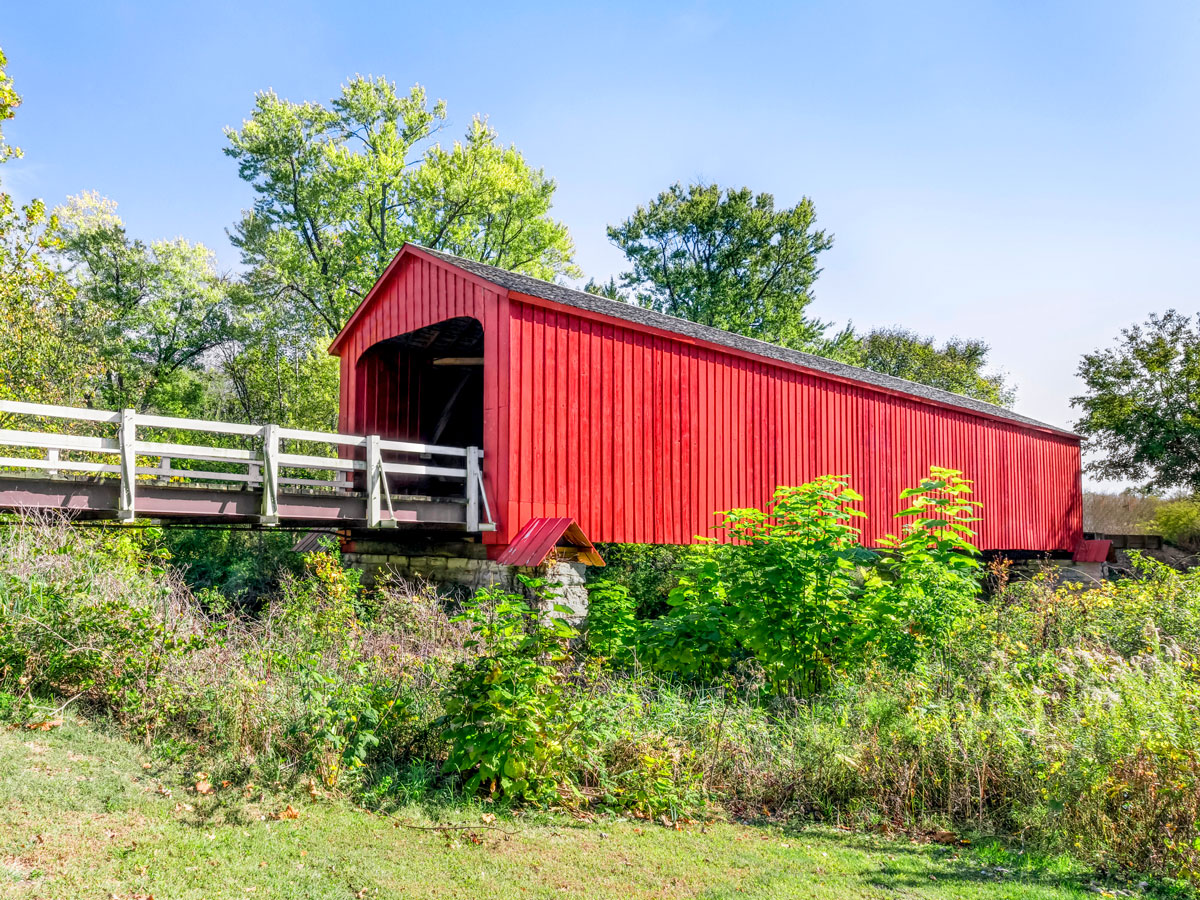
Roseman Covered Bridge – Winterset, Iowa
The covered bridges of Iowa have become known worldwide thanks to Robert James Waller’s novel The Bridges of Madison County and the 1995 movie of the same name. Today, the famous county has six covered bridges remaining.
The most notable is the Roseman Covered Bridge, also known as the Oak Grove Bridge. Built in 1883, the bridge measures 225 feet long. As well as being associated with Clint Eastwood and Meryl Streep, the eye-catching red bridge with gleaming white rails has a haunted reputation among locals. According to legend, the bridge’s name came from an 1892 chase involving a sheriff’s posse and a man who seemingly rose up straight through the roof of the bridge and disappeared into thin air.
Horton Covered Bridge – Amnicon Falls, Wisconsin
Wisconsin’s Amnicon Falls State Park is the site of Horton Covered Bridge, named for its designer Charles M. Horton. In 1897 and 1898, he patented designs for a bowstring bridge, which he argued was stronger, longer-lasting, and easier to erect than many existing bridge designs. The bridge that bears his name originally was part of a highway, but it was moved to the nearby state park in 1930. The roof, which was not a part of Horton’s original design, was added in 1939. The waterfalls that the bridge now overlook add an extra layer to its scenic charm.
Horton Mill Bridge – Oneonta, Alabama
Not to be confused with the previously mentioned bridge with a similar name in Wisconsin, the Horton Mill Covered Bridge is one of the highest covered bridges in the country, standing 70 feet above the Black Warrior River. It is one of three covered bridges in Alabama’s Blount County. The 203-foot-long bridge was built in 1934 and underwent restoration in 1974 and again in 2013. The bridge is named for Talmedge Horton, one of its builders and part of a local gristmilling family. Beautiful latticework adorns the sides of the bridge, allowing for dramatic views down into the river gorge.
Straddling the Doe River, the Elizabethton Covered Bridge debuted in 1882. Colonel Thomas Matson, who had come up with the idea for New York’s elevated railroad tracks, designed the bridge, which was hailed as an engineering feat at the time. It lived up to its reputation in 1901, when a flood destroyed all the county’s other bridges on the river. Located in Elizabethton’s downtown area, the bridge is now part of the city park, and a number of events are based around the landmark, including the Covered Bridge Days Festival in September. The locals are proud of the gleaming white bridge, and rightly so.
Felton Covered Bridge – Felton, California
The tallest covered bridge in the nation is the Felton Covered Bridge in California. Now part of a park in Santa Cruz County, the bridge is only open to pedestrians. Walking through it, you can look up to appreciate its 35-foot height and its intricate criss-cross roof design. The bridge was completed in 1893 and for years was the only route into the town of Felton. After it closed to vehicular traffic in 1937, it became a popular landmark and was added to the National Register of Historic Places in 1973.
Harpersfield Covered Bridge – Ashtabula, Ohio
Built in 1868, the truss bridge in Harpersfield Township, Ohio, is one of only 16 in the U.S. that you can still drive a car across. At first glance, you might wonder why the covered wooden bridge only spans a portion of the Grand River. That’s because a severe flood in 1913 washed away a large chunk of land on one side of the bridge, leaving the 228-foot-long bridge open-ended. To reconnect it to the new riverbank, a steel span was attached. Additional renovations in the 1990s added a walkway.
Stark Bridge – Stark, New Hampshire
Unsurprisingly, covered bridges attract artists, photographers, and history enthusiasts. So when there was talk of replacing the bridge that spanned New Hampshire’s Upper Ammonoosuc River with a shiny new steel bridge in the 1950s, public outcry was so great that it convinced the people of Stark they had a landmark worth restoring.
The bridge had already experienced an eventful past. It was built in 1862 but washed away during floods in the 1890s. After the bridge was retrieved and put back in place, stronger stone foundations were installed. Further structural problems in the 1940s led to townspeople suggesting the replacement in the 1950s, but ultimately the state helped to fund restoration and repairs, and the bridge is now considered one of the prettiest in the country.
Goodpasture Bridge – Vida, Oregon
The Goodpasture Bridge, which extends 165 feet across the McKenzie River, is different from other wooden bridges due to one simple design feature: It has windows. Each side of the bridge features 10 Gothic-style louvered windows that lend the bridge a distinctive flair. Built in 1938 and named for a local farmer, Goodpasture is Oregon’s second-longest covered bridge. The state has resisted replacing it with a steel span, instead opting to invest in a $2 million overhaul and reinforcement that added LED lighting for spectacular night views. And at Christmas, the white bridge is decked out in an array of seasonal colors.
Cornish-Windsor Bridge – Cornish, New Hampshire and Windsor, Vermont
Connecting the two towns in its name, the Cornish-Windsor Bridge also links two states. Cornish is on one bank of the Connecticut River, in New Hampshire, while Windsor is on the other bank, in Vermont. When it was built in 1866, it became the fourth bridge to cross this particular spot after earlier crossings had washed away in floods. The state of New Hampshire purchased the bridge in 1935 and operated it for a period as a toll route.
During Vermont’s time as a dry state (meaning liquor sales were prohibited), the bridge was a convenient means for thirsty Vermonters to buy alcohol where it was still legal in New Hampshire. While that’s no longer an issue today, you’ll just need to remember to follow the advice at the entrance of the bridge: “Walk your horses or pay two dollars fine!”
Advertisement
More from our network
Daily Passport is part of Inbox Studio, an email-first media company. *Indicates a third-party property.
Architecture •November 1, 2023•Updated: November 1, 2023
By Daily Passport Team
Author
Daily Passport Team
Daily Passport writers have been seen in publications such as National Geographic, Food & Wine, CBC, Condé Nast Traveler, and Business Insider. They're passionate about uncovering unique destinations and sharing expert tips with curious travelers.
For the quickest route to exploring the unique culture of a European city, head directly to the main square. Whether they call them squares, piazzas, praças, or plazas in the local language, these Old World spaces are usually anchored by a striking cathedral, palace, or civic building. Serving as the central hub of their cities, they have played host to countless celebrations, demonstrations, and coronations over the centuries. So, grab a bench or a café chair and get ready to take in the beauty of these five grand European city squares.
Marienplatz, the central square of Munich, wouldn’t belong anywhere else but Germany. For starters, it features a charming (and perhaps slightly quirky) 260-foot mechanical clock, Rathaus-Glockenspiel, whose 43 chimes and 32 spinning mannequins reenact scenes from Munich’s history.
Two massive city halls, one dating back to the early 1300s and a newer one from the 19th century, surround the square, both laden with heavy dollops of architectural ornamentation and topped by pointy towers. You’ll also find monuments to military history here, including a central column erected to mark the end of Swedish occupation during the Thirty Years War.
In December, a bustling Christmas market takes over Marienplatz, lit by twinkling lights, with mulled wine and hand-carved wooden Nativity scenes for sale. Marienplatz, though badly damaged by Allied bombs in World War II, has been shored up and restored to its ancient role as the cultural heart of Munich. Stop by for a bit of German history and, if you time your visit to coincide with the chiming of the Glockenspiel, a bit of twirling levity with your lesson.
Like Venice’s Piazza San Marco, Lisbon’s vast Praça do Comércio is meant to impress visitors arriving by boat, a fitting entrance for the capital of a seafaring nation. One end of the praça, or plaza,opens up to the River Tagus, and the other three sides of the square are lined by a uniform and striking array of 18th-century buildings painted a brilliant shade of yellow. The line of buildings on the side of the square opposite the river is broken by a white marble triumphal arch that leads into the Baixa neighborhood of Lisbon.
Many of the world’s notable city squares were established over centuries and contain buildings of contrasting architecture and vintage. However, the Praça do Comércio was built in the decade immediately after the 1755 earthquake that leveled most of Lisbon, so the square’s elegant symmetry was by design — a symbol of stability and enduring beauty for the citizens, as well as a message to the world that the city was again open for business. Even if you enter the square on foot rather than by boat, the expansive square’s balance and grandeur still impress.
Like the spindle on a great turntable, Nelson’s Column stands serenely in the center of Trafalgar Square while noisy London spins around it. Indeed, since 1290, this spot has been so central to the English that distances to and from the city have been measured from Trafalgar Square, or Charing Cross, as it was called at the time.
Back then, the site was a walled courtyard, part of Whitehall Palace, but architect John Nash envisioned a public gathering space for the site and began work on his plan in 1812. Trafalgar Square was finally completed in 1844, a year after the 169-foot-tall memorial to the war hero Lord Nelson was erected.
The lively square, still a regular gathering place for ceremonies, celebrations, and political demonstrations, is flanked by the National Gallery, St. Martin-in-the-Fields Church, and the Mall — a wide, tree-lined, red-paved boulevard that leads to Buckingham Palace. Other public works in Trafalgar Square include fountains and more statues, as well as the Fourth Plinth, an elevated site where a rotating display of artists’ sculptures are mounted. At the northeast end of the square near the National Gallery, look for the bronze plaques that were mounted in the pavement and walls which depict the Standard Imperial Measures, replacing wooden predecessors that burned in an 1834 fire in Westminster.
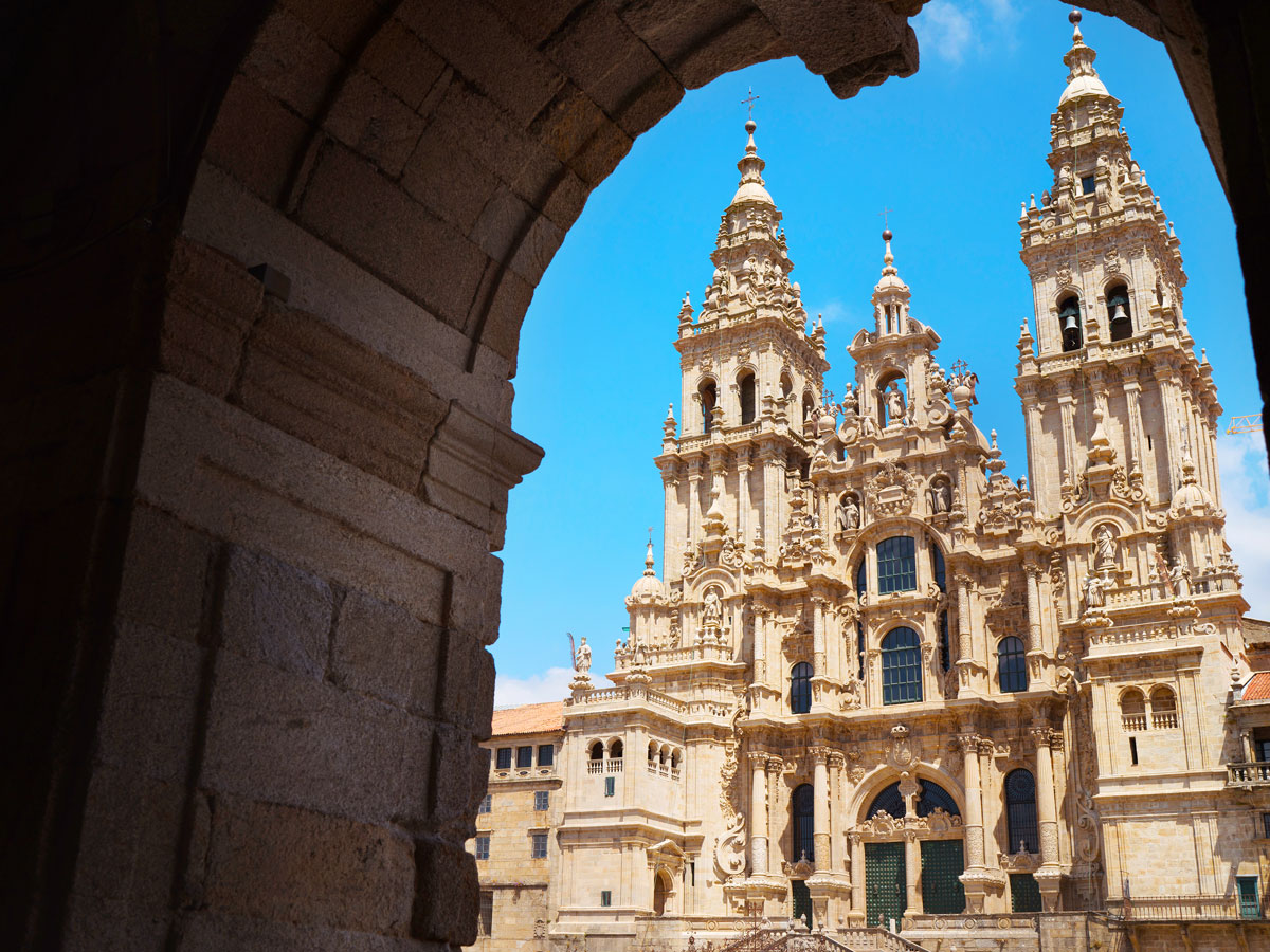
Praza del Obradoiro – Santiago de Compostela, Spain
The great cathedral of Santiago de Compostela, the capital of Spain’s northwest Galicia region, is thought to hold the remains of the apostle James and marks the end of the nearly-500-mile Camino de Santiago pilgrimage trail. The broad square in front of the cathedral, the Praza del Obradoiro (praza is the Galician version of the Spanish plaza), is therefore often filled with groups of hikers, standing, sitting, and reclining with their backpacks and recovering from their journey.
Another of the grand buildings that make up the sides of the square is the Hostal de Los Reyes Católicos. Now a luxury hotel, it was originally built by King Ferdinand and Queen Isabella in the 15th century to serve as a hospital and hostel for pilgrims to Santiago de Compostela.
Flanking the other sides of the square are the Colexio de San Xerome, a university that dates back to 1501, and a governmental palace that is now the town hall. The elegant buildings along the praza are serenely uniform in the color of their stonework, but each facade represents a different architectural style, which makes a survey from the center of the square a delight for visually-minded visitors.
This grand and photogenic piazza was purpose-built for crowds in 1656 at the behest of Pope Alexander VII, who wanted to return Rome to its ancient role as one of the great cities of the world. Either end of the elliptical piazza is framed by two semicircular colonnades designed by Bernini, the sculptor and architect responsible for many works at the Vatican. The center of the ellipse is marked by an Egyptian obelisk, flanked on either side by a pair of stately fountains.
Most days, tourists pass through the square on their way to visit the Sistine Chapel or St. Peter’s Basilica, but on Sundays, they gather here after noon to hear the Pope give his weekly address to the faithful from a balcony in his apartments. (Occasionally, he says mass from a balcony at the top of the basilica.) If you can’t catch a glimpse of His Holiness, maybe the sight of 140 saints, popes, and martyrs perched atop Bernini’s colonnades (in marble form) can lift your spirits heavenward.
Advertisement
More from our network
Daily Passport is part of Inbox Studio, an email-first media company. *Indicates a third-party property.
Have You Been to These 6 Rarely Visited Countries?
By
Daily Passport Team
Read time: 6 minutes
November 1, 2023
Updated: November 1, 2023
Have You Been to These 6 Rarely Visited Countries?
Culture •November 1, 2023•Updated: November 1, 2023
By Daily Passport Team
Author
Daily Passport Team
Daily Passport writers have been seen in publications such as National Geographic, Food & Wine, CBC, Condé Nast Traveler, and Business Insider. They're passionate about uncovering unique destinations and sharing expert tips with curious travelers.
Consider yourself a seasoned traveler? Already checked iconic landmarks like Taj Mahal, the Eiffel Tower, and Machu Picchu off your list? Though the number of truly off-the-beaten path places to visit is dwindling as global tourism booms, there are a handful of countries where you can still immerse yourself in local culture without hordes of other tourists. From a hard-to-pronounce European microstate to an exotic South Pacific kingdom, here are six magical — and rarely visited — countries you should consider visiting.
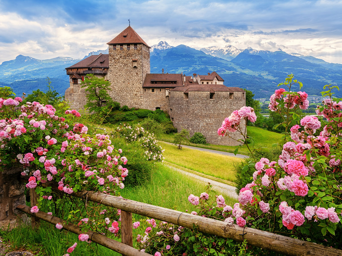
Liechtenstein, a tiny German-speaking country nestled between Austria and Switzerland, is doubly landlocked. In other words, it’s a landlocked nation surrounded by landlocked nations — and it’s one of only two in the world, along with Uzbekistan. But don’t let the lack of beaches (or airports) keep you away — Liechtenstein’s alpine terrain, medieval architecture, and fairytale vistas are an epic draw.
As are its historic castles and fortresses. Dating from the 12th century, the striking Vaduz Castle overlooks the capital of Vaduz and houses the royal family. Visitors can’t tour the fortress, but the famous Burg Guternberg (Gutenberg Castle) in the charming town of Balzers is open to the public, who wish to explore the beautiful rose gardens and medieval castle’s interior.
The majestic Central Alps stretch across about half of Liechtenstein, making mountain activities a high point of any visit. Winter offers world-class skiing without the crowds, while warmer weather makes for incredible hiking and biking — not to mention an opportunity to explore the country’s hillside wineries.
Travelers seeking a secluded escape — or a great glass of wine — should consider Moldova. Located between the Ukraine and Romania, this small, landlocked country offers a budget getaway amidst rolling, green pastures and picturesque vineyards.
Wine is a huge part of the country’s heritage — with a host of hyper-local and more well-known European varietals produced in the region for at least 5,000 years. In fact, the world’s largest wine collection is in Moldova. Located at Mileștii Mici vineyard outside the capital of Chișinău, the property’s labyrinth of underground storage tunnels house over 1.5 million bottles. Touring the site and visiting the tasting room are a must.
The official language of Moldova is Romanian, but Russian is also widely spoken. You’ll hear a mix of both in Chișinău, which features elegant, Old World European and stark, Brutalist-style Soviet architecture amid manicured parks, lively wine bars, and several museums. Just outside of town is Orheiul Vechi (Old Orhei), a historical and archeological complex featuring a series of ancient caves and a monastery dating from the 13th century. The site is an ongoing archaeological dig and is considered one of the country’s most important historical locations.
An easy flight from New Zealand or Australia, New Caledonia is an archipelago and French territory in the Pacific Ocean. Best known for its picture-perfect, white sand beaches and its diverse marine life, New Caledonia famously attracts scuba divers and snorkelers who come to explore inlets and lagoons that are alive with sea turtles, dozens of species of shark, and the dugong — a marine mammal closely related to the manatee.
Meanwhile, one of the world’s largest barrier reef systems surrounds the main island of Grand Terre. The Natural Park of the Coral Sea, the world’s second-largest marine preserve home to colorful coral and fish, encompasses 95% of the waters surrounding New Caledonia.
A visit to the capital of Nouméa is a must. In addition to high-end boutiques, you’ll find a plethora of French bistros and seafood restaurants, wine bars, and gourmet markets selling imported French cheeses and other delicacies. Another popular stop is the Isle of Pines, a striking island famous for its towering evergreens that juxtapose otherworldly turquoise waters. Romantics will want to fly over the Heart of Voh. Only visible from the sky above, this heart-shaped swamp within a mangrove forest is a breathtaking natural phenomenon.
A tiny nation on the island of Borneo — Brunei is one of the least-visited countries in the world. Nature lovers seek out the small sultanate for its virgin rainforests. While other territories on the island have cleared much of their forested land, Brunei boasts lush jungle habitat including the massive Ulu Temburong National Park. Covering more than 120,000 acres, the park is accessible via longboat ferry and offers guided jungle trekking, canopy walks, and swimming in natural pools. That said, only 1% of this massive, unspoiled forest is accessible to visitors.
Architecture buffs will also enjoy a trip to Brunei since the country offers some of the most beautiful Islamic architecture in the world. The capital of Bandar Seri Begawan is home to the Jame’ Asr Hassanil Bolkiah Mosque, which features 29 golden domes. Additionally, strolls through the city’s squares and open markets, which buzz in the shadows of the opulent royal palace of Istana Nurul Iman, are a must visit. As is the floating village of Kampong Ayer. Foodies will revel in the country’s signature fried rice and noodle dishes that fuse the flavors of Malaysia, Singapore, and Indonesia.
A necklace of Caribbean islands adjacent to Saint Lucia, Barbados, and Grenada, Saint Vincent and the Grenadines has only had an international airport since 2017. And still, many visitors arrive to these tropical islands via sailboat, private yacht, or ferry.
More affordable ports of call include Union, Bequia, and Mayreau, but high rollers tend to stay at exclusive resorts in Canouan or on the privately-owned island of Mustique. Wherever you end up, you’ll enjoy pearl-colored or black-sand volcanic beaches, pristine aqua waters, abundant ocean life, and plenty of local rum punch.
Saint Vincent is the main island in this Anglo-Caribbean chain of 32 islands. The total landmass of all the islands is only about 150 square miles, and many individual islands are uninhabited and unspoiled. It’s no surprise, then, that most visitors (when not soaking up sun on the beach) spend their vacation days here sailing, fishing, diving, and snorkeling. Fun fact: This tropical paradise is also the backdrop for the Pirates of the Caribbean film franchise.
The Kingdom of Tonga, a nation of over 170 islands in the South Pacific, might be best known for its uncrowded beaches and warm hospitality. Together, these characteristics ensure an authentic island experience.
To get a true taste of Tongan culture, participating in a Tongan feast is a must. These luau-like gatherings include traditional dances and ritual performances. And then there’s the food itself: dishes served on trays made from coconut fronds, including spit-roasted pig, raw fish cured in lemon juice and coconut milk, steamed octopus and seafood, and local fruits and vegetables such as breadfruit, plantains, cassava, and taro.
Beyond feasting, the islands offer incredible beaches and inlets for relaxing and exploring. Look for flying foxes and abundant marine life. From July through October, it’s even possible to swim in waters crowded with migrating humpback whales. Portions of the coastline, especially on the island of Tongatapu, feature stunning eruptions of seawater exploding from hollow channels of craggy lava rock. These formations were established over thousands of years due to volcanic activity.
Advertisement
More from our network
Daily Passport is part of Inbox Studio, an email-first media company. *Indicates a third-party property.