7 Iconic Brutalist Buildings for Architecture Buffs to Visit
By
Julia Hammond
Read time: 5 minutes
October 13, 2023
Updated: October 13, 2023
7 Iconic Brutalist Buildings for Architecture Buffs to Visit
Architecture •October 13, 2023•Updated: October 13, 2023
By Julia Hammond
Author
Julia Hammond
Julia is a U.K.-based travel writer whose work has been featured in The Independent, The Telegraph, The New Zealand Herald, and Culture Trip, among others. She’s an enthusiastic advocate for independent travel and a passionate geographer who has had the privilege of traveling to more than 130 countries in search of a story.
Brutalism originated after World War II in Marseilles, France, where the famous Swiss architect Le Corbusier described a housing development he was working on as “bétonbrut,” which translates to raw concrete. This material features heavily, though not exclusively, in Brutalist architecture, and Le Corbusier’s vision was to build in such a way that nothing was hidden. But this concept of honesty in construction divides opinion, and since its inception, Brutalism has been a “love it or hate it” style of architecture. Find out which camp you fall into as you take a look at these seven beautiful Brutalist buildings around the world.
In the 1920s, the architect Le Corbusier developed a visionary housing concept he called Unité d’Habitation (housing unit). It would be many years before he could realize his vision, as La Cité Radieuse took shape in Marseille, a port city in the south of France, between 1947 and 1952. A collection of 337 two-story apartments — plus shops, galleries, restaurants, and a hotel — create a concrete community on stilts. Broad corridors run through the complex on some of the floors, forming elevated streets, while the flat roof is home to a running track, swimming pool, and shared terrace. Four similar developments followed: in Nantes-Rezé, France; Berlin, Germany; Briey, France; and Firminy-Vert, France. Since 2016, the Marseille original has held UNESCO World Heritage status for its contribution to modern architecture.
This fabulously unique library was the work of William Pereira. Appropriately for a library, the architect wanted to create a sense of holding knowledge in one’s hands. The building took two years to come together, opening in 1970, and consists of eight floors made of glass and reinforced concrete. The cantilevered structure required heavy-duty slope beam columns to provide sufficient support, but these also serve to enhance the design. A rooftop carillon was installed in 1989, which chimes at hourly intervals during the day. Visitors can take an online or self-guided tour of the library at any time, or visit at noon to listen to a live carillon concert. Since 1995, this Brutalist gem has been dedicated to Theodor Geisel, the children’s author responsible for Dr. Seuss, and his wife Audrey.
Habitat 67 is an iconic Brutalist complex located in Montreal, Quebec. Taking the lead on this pioneering project was a young architect named Moshe Safdie, who later achieved worldwide fame. Unveiled at the 1967 World Exposition, the development was intended to demonstrate that prefabricated structures could be both practical and beautiful. Habitat 67 comprises 158 apartments over 12 levels; each one was made in a factory and craned into place. The modular construction enables each property to have its own roof garden, and the different sizes of the apartments prevent the design from becoming uniform and dull.
After London suffered extensive bombing during World War II, just 48 people remained residents of the area that’s now the Barbican at the time of the 1951 census. Thus, architects were given a space that could be used for something bold and innovative. Chamberlain, Powell, and Bon — the firm which won the contract to reimagine the area — created a raised city within a city that would be the basis for a new community of around 4,000 people.
Though the architects went big on concrete, the site isn’t all hard edges — the Barbican Conservatory provides an oasis-like injection of greenery, while the lakeside terrace and sculpture court offer further spaces for leisure and recreation. In 2001, the development was awarded England’s Grade II status, a measure of how important it was to retain the complex and its architectural integrity. Guided tours take place on a regular basis.
Teresa Carreño Cultural Complex – Caracas, Venezuela
The Teresa Carreño Theater, a landmark Brutalist building in Caracas, hosts live events across two auditoriums: Sala Rios Reyna Hall and Sala José Félix Ribas. You’ll find this cultural complex in the Bellas Artes district of the Venezuelan capital. Architecture tours showcase this and other significant buildings in the city, but the best way to experience the building is to go inside — where opera, music, dance, and theater performances are staged regularly. And the theater, named after a Venezuelan pianist, is not the only famous Brutalist structure in the city. During your visit, be sure to check out the Centro Simón Bolívar (also known as the Towers of Silence) and the Parque Central Urbanistic Complex, which houses the city’s Contemporary Art Museum.
Jatiya Sangsad Bhaban, the National Parliament House of Bangladesh, was constructed from concrete, brick, and white marble. Set among artificial lakes, its imposing walls are almost fortress-like, and act as insulation from the heat outside. Architect Louis Kahn utilized different shapes to emphasize the different functions of the buildings in this complex. The geometric designs used to create the openings in the columns were a nod to Bengali cultural motifs. Construction began when the country was still East Pakistan, and as the newly independent, fledgling state was born, Jatiya Sangsad Bhaban became a symbol of the start of a new era. Kahn died before the project was completed in 1982, but it was posthumously awarded the Aga Khan Award for Architecture.
You know you’ve hit on a controversial design when people start calling for demolition before the building is even finished. That’s exactly what happened as Boston City Hall approached completion in the late 1960s, and it has polarized opinions ever since. Some find beauty in its stark lines, while others believe they’ve never laid eyes on anything as ugly. Regardless, it certainly makes a statement. The firm responsible for the project, Kallmann McKinnell & Knowles, produced the winning design in a competition that attracted more than 250 entries. The brick that characterizes its lower levels contrasts to the cantilevered concrete and repetitive shapes of the upper part of the building. Bold, functional, and unique, it’s one of Boston’s greatest architectural talking points.
Advertisement
More from our network
Daily Passport is part of Inbox Studio, an email-first media company. *Indicates a third-party property.
Land of Fire and Ice: 7 Breathtaking Landmarks in Iceland
By
Julia Hammond
Read time: 5 minutes
October 13, 2023
Updated: October 13, 2023
Land of Fire and Ice: 7 Breathtaking Landmarks in Iceland
Outdoors •October 13, 2023•Updated: October 13, 2023
By Julia Hammond
Author
Julia Hammond
Julia is a U.K.-based travel writer whose work has been featured in The Independent, The Telegraph, The New Zealand Herald, and Culture Trip, among others. She’s an enthusiastic advocate for independent travel and a passionate geographer who has had the privilege of traveling to more than 130 countries in search of a story.
Iceland possesses a raw and rugged beauty unlike anywhere else on Earth. In this Nordic island nation, geothermal and tectonic processes combine with often wild weather to dramatically shape the landscape. Visitors can travel almost as far north as the Arctic Circle to see glaciers that hide subterranean volcanoes and glittering ice caves, waterfalls tucked away at the end of remote valleys, and beautiful, unspoiled beaches backed by cliffs teeming with birds. Wondering where to start? Here are the seven most breathtaking natural landmarks in Iceland, the so-called “Land of Fire and Ice.”
Waterfalls are abundant in Iceland, but a handful of them stand out for their remarkable geology. One of the most striking is Svartifoss, flanked by charcoal gray basalt columns that were created from a lava flow 300,000 years ago. Located in the heart of the Skaftafell nature reserve, it forms part of Vatnajökull National Park.
To reach Svartifoss, you’ll need to follow a mile-long hiking trail that slowly climbs up from the visitor center. Standing less than 66 feet high, Svartifoss doesn’t come close to being Iceland’s tallest waterfall — that honor goes to Morsárfoss, which is more than 10 times the size. Yet, Svartifoss is a tourist favorite. In summer, lush vegetation springs up at the water’s edge, while in winter, under a dusting of snow, it’s one of the most exquisite sights in the country.
Jökulsárlón is one of the jewels of Iceland’s popular south coast. The glacier lagoon sits in the shadow of Breiðamerkurjökull, an outlet glacier of the much larger Vatnajökull glacier. As Breiðamerkurjökullr travels downhill under the effect of gravity, chunks of ice calve into the saltwater lagoon of Jökulsárlón.
Zodiacs ferry passengers to the glacier’s mouth and weave in and out of the bobbing hunks of ice. Often, you’ll see seals sprawled out on the larger icebergs or swimming leisurely in the chilly water. Walk along the shoreline towards the ocean, and you’ll soon reach Fellsfjara, better known by its “Diamond Beach” nicknames. Here, the waves interact with the icebergs that have drifted out to sea, washing them back onto land and eroding them until they melt into the black sand.
Strokkur, Iceland’s most active geyser, is the reason most people come to the Haukadalur valley. Also referred to as the Geysir Geothermal Area, it’s a highlight of Iceland’s famous Golden Circle route. This is where you’ll find the original Geysir, now inactive, and a wealth of other steaming fissures, mud pots, and mineral speckled grounds.
But all eyes turn to Strokkur: This landmark is a reliable performer, putting on a show about every six to 10 minutes. The first sign of action comes as the turquoise pool begins to shiver and then dome. As the surface of the water fractures, the geyser shoots a plume of superheated water and steam into the air, typically between 30 and 60 feet high.
Until 2009, Studlagil’s natural beauty was hidden underwater. Then, a dam was constructed upstream as part of the Kárahnjúkavirkjun hydroelectric power project. As a result, the level of the Jökulsá á Dal River fell, and the stunning canyon was revealed. Studlagil has rapidly become one of East Iceland’s must-see attractions thanks to its remarkable concentration of rust-covered basalt columns. If you visit in early summer, the water should be a dazzling blue-green. But even when glacial water, heavy rainfall, or snow melt turns it a dull gray, the canyon’s still an impressive sight.
Reynisfjara is a breathtaking beach located near the village of Vik on Iceland’s south coast. A broad strip of black sand lines the shore, and behind it sits Hálsanefshellir, a sizable cave cut by the waves. The cave’s walls are formed from basalt columns and cooled pillow lava. Flanking the cave is an 1,115-foot-tall tuff cliff, the ocean-fronting face of Reynisfjall mountain. Throughout the summer breeding season, puffins make their nests on its grassy ledges.
Just offshore, the skinny, gnarled sea stacks of Reynisdrangar bear the scars of constant wave erosion. But it’s the waves themselves that make this place infamous — they often arrive unannounced and sweep back to the sea with great force.
TheLandmannalaugar area is often considered the highlight of Iceland’s Highlands. Accessible by road only for a short period of time in summer, Landmannalaugar forms part of the Fjallabak Nature Reserve, occupying a space on the edge of the Laugahraun lava field backed by hills. These rhyolite peaks are streaked with red, blue, yellow and green, making this one of the most colorful areas in the country.
Locals often call this place “the People’s Pools” because the area is geothermally active. Once, this would have been a stop for weary travelers and farmers moving livestock between grazing lands, but today it’s a tourism hub. One of the most popular activities after a day of hiking in Landmannalaugar is to follow the wooden boardwalks to its naturally heated warm water pools for a restorative soak.
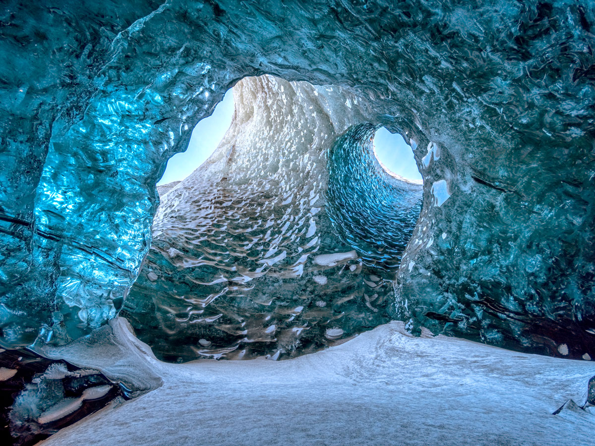
With the arrival of spring in Iceland, rising temperatures create meltwater streams in glaciers such as Vatnajökull. This water trickles down through cracks and crevasses in the ice, hollowing out vast caverns that are hidden from sight. Crystal Cave is one such example, and because of the way it’s formed, the precise location of the cave can change from one year to the next.
By late November, the colder weather has stabilized the ice, and it’s considered safe enough for visitors kitted out with helmets, crampons, and ice axes to venture across the glacier with a qualified guide. Inside the cave, an extraordinary scene awaits — the ice cave’s translucent blue ceilings and walls are as if a hugely talented sculptor had been at work, yet no human could match the work of nature.
Advertisement
More from our network
Daily Passport is part of Inbox Studio, an email-first media company. *Indicates a third-party property.
History •October 12, 2023•Updated: October 21, 2025
By Daily Passport Team
Author
Daily Passport Team
Daily Passport writers have been seen in publications such as National Geographic, Food & Wine, CBC, Condé Nast Traveler, and Business Insider. They're passionate about uncovering unique destinations and sharing expert tips with curious travelers.
Hotels with rich histories add a layer of intrigue to any vacation. That’s especially true when those histories are of the paranormal variety — from ghosts that wake up guests just for fun to deceased hotel owners still said to roam the halls at night. Celebrate the spooky season with a stay at these 19 hotels with haunted histories… if you dare.
Most people know the Stanley Hotel as the inspiration for Stephen King’s The Shining, which he wrote after staying just one night at the property in 1974. The hotel opened in 1909 as an oasis in the Colorado mountain wilderness, boasting modern amenities for the time, such as electric lights, en-suite bathrooms, and telephones. But even before Stephen King’s arrival, the hotel had a reputation for paranormal activity.
Hotel owner F.O. Stanley, who died in 1940, has been a common sighting at the check-in desk since his death. There have also been reports of mysterious piano playing, laughter, shadowy figures, items moving on their own, and lights turning on and off. Ghost-goving guests at the hotel can book a special package guaranteeing them a stay on the most haunted floor, plus a ticket to the evening ghost tour.
One of Europe’s first grand hotels, the Langham debuted in London in 1865 to much fanfare — even the Prince of Wales came to the opening. It has remained a posh place ever since, hosting illustrious guests such as Charles Dickens, Sir Arthur Conan Doyle, and Princess Diana.
But among those famous visitors, you can also find occupants of the ghostly kind — particularly in Room 333, considered to be the most haunted hotel room in London. It’s said to be home for more than a few ghosts, including one who likes to shake the bed just for fun, a Victorian doctor who stares into the distance, and a German prince in military dress. Throughout the hotel, you may also be greeted by a man with a wounded face, a footman in a powdered wig, a lost butler, or Emperor Napoleon III himself.
In the heart of Dublin, the Shelbourne is reportedly haunted by a ghost named Mary Masters, who loves to mess with water fixtures in one of the rooms. She died of cholera in the hotel, which opened in 1824, when she was just seven years old. Mary enjoys startling guests by opening and closing wardrobe doors, but her favorite thing to do is turn on the water. Guests regularly report the taps, shower, and tub being turned on unexpectedly. In fact, so many guests have recounted the same unexplained activities that the hotel had a staff member sleep in the room to see if the claims were true — it turns out, the staff member had the same experience.
The Fairmont Le Château Frontenac towers over Quebec City, high up on a hill overlooking the old town and its European-style streets. It replaced a previous castle used as wartime headquarters, and though it’s styled to look much older, it has only been there since 1893 and has been a hotel the entire time. But even still, the hotel reportedly has ghosts roaming the halls. One is Louis de Buade, Comte de Frontenac, who mourns his lost love, and the other is a woman dressed in a nightgown who enjoys waking people up at night.
It doesn’t get much spookier than a hotel with an old morgue in the basement (now conveniently located right next to the spa). The Crescent Hotel, often deemed the most haunted hotel in America, originally opened in 1886 as a luxurious resort for wealthy train travelers making their way through Eureka Springs. It didn’t stay that way for long, though.
Within just a few years, the hotel fell into disrepair. It reopened as the Crescent College and Conservatory for Young Women in 1908 and operated as a college of some form until 1934. Then, in 1937, the dark history of the place began to take shape. A crooked “doctor,” Norman Baker, bought the property and turned it into a cancer hospital (hence the morgue). The problem was, he wasn’t offering actual treatment — instead, he was hawking natural spring water with flavoring as a bogus cure. After countless deaths, the hospital was shut down in 1940, and Baker was sent to prison.
The hotel’s current iteration opened in the early 2000s, but ghosts of the past remain. Guests and paranormal investigators have reported seeing full-body apparitions of adults and children, and the hotel even offers ghost tours of the property.
Dragsholm Slot was originally built in 1215 as a palace. From there, it transformed into a castle, a prison, back to a castle, and now a hotel. It’s often considered to be one of the most haunted buildings in Denmark — legend says it’s home to more than 100 ghosts.
Three of them are more famous than the others. The White Lady was the daughter of one of the noblemen who lived in the building. She fell in love with a commoner — something her father viciously disapproved of — and as punishment, she was imprisoned and bricked into the castle walls. She’s reportedly seen wandering the halls wearing a white dress. The second famous ghost, James Hepburn, died in the dungeon in 1578 — now, his ghost tears into the courtyard on horse and carriage every night. The third ghost, the Grey Lady, is much happier than the others. She had a terrible toothache in life that was healed by someone at the castle. In death, she is said to traverse the halls looking for good deeds to do as repayment.
According to the Hotel Monte Vista, more than seven ghosts haunt the halls of the property — and guests are encouraged to try to communicate with them. The hotel opened on January 1, 1927, just off Route 66 in Flagstaff. It’s connected to other downtown buildings through secret underground tunnels, and it was used as a speakeasy during Prohibition. Famous visitors have included Mary Costigan (who broadcast her radio show from there), Michael J. Fox, Bob Hope, Bing Crosby, and Siouxsie Sioux.
But as far as ghostly guests, you can expect to meet a man who messes up the bed and turns on the TV at full volume, a rocking chair that moves on its own, a bellboy, a crying baby, a dancing couple, and a bank robber who rearranges the bar and wishes people a good morning.
The popular First World Hotel in Malaysia isn’t just a colorful favorite — it’s also the world’s largest hotel, with more than 7,300 rooms. Guests with rooms on the 21st floor may find it a bit difficult to get to bed at night, however, as it’s rumored to be a cursed floor that the elevator skips. In other rooms at the hotel, visitors report seeing vanishing figures and being pushed while sleeping. The hotel has a built-in casino, which many say is the reason for the ghosts; supposedly people who have lost their fortune there decided never to leave.
The Lord Milner Hotel opened in 1899 just as the South African War was beginning. During the war, it was a military hospital with a lookout tower. It reopened in 1970 after renovations, with 15 rooms decorated in old-world splendor. But it’s the hotel’s history as a military space that gave way to the ghosts reported to live there today.
One is Kate, a young nurse who used to play cards with soldiers as they recovered; she tends to walk up and down the staircase. Mary-Anne likes to jiggle the doorknob on Room 26. Lucy walks around in her nightgown. Olive hangs out in the gardens. British officers and soldiers congregate on the hotel balcony and spend time in the library. And with even more ghosts beyond that, the hotel certainly lives up to its legend as the most haunted hotel in South Africa.
In 1972, the first hotel rooms opened in the permanently docked Queen Mary, a former luxury ocean liner that also served as a troop ship for World War II. It now serves as a kind of floating museum in Long Beach, California, but even before the ship was permanently docked, people reported hearing knocking on doors and seeing full-body apparitions, flickering lights, mysteriously running water, a woman in a wedding gown, disappearing children, and ghostly crewmembers. Today, the hotel might just be one of the most haunted in America — curious visitors can take ghost tours to judge for themselves.
Le Château de Marçay is a 15th-century castle that was converted into a 22-room hotel in 1973. A mysterious legend lies at the heart of the property’s rumored ghost encounters. It’s said that a former female resident of the castle turned into a werewolf every night, until she was shot by a terrified farmer. When the sun rose, the farmer realized he hadn’t shot a wolf at all, but instead a woman. He secretly buried her, in her white shroud, on the property. Now she’s seen every night, wandering the courtyard and the castle halls in her white dress.
The Congress Plaza Hotel opened in 1893 to house visitors to the World’s Columbian Exposition that same year. In the years since, president after president has stayed at the ornate hotel, including William Taft, Calvin Coolidge, and Franklin Roosevelt — a distinction that earned it the nickname “The Home of Presidents.” It’s also known, however, as the most haunted hotel in Chicago. Dozens of ghosts are said to walk the halls, from businessmen who perished in nearby Lake Michigan to roller skaters who played in the roller rink before it became a ballroom.
For more than 800 years, Dalhousie Castle has stood guard over the Scottish countryside. In the beginning, the fortress and castle welcomed knights suited up in armor, who crossed a moat to get into the building. The moat is still there, along with remnants of the original drawbridge, but its function has changed. The castle has been used as a fortress, a home, a boarding school — and, since 1972, a hotel. Dalhousie runs ghost tours for curious guests to see some of the famous specters — like the Grey Lady, a mistress of one of the former lairds who was locked in a turret by his wife around 1500, and Sir Alexander Ramsay, a former resident who died there in 1342.
The most well-known ghost stories at the Pfister Hotel come from professional sports teams — some players have been so scared that they refuse to stay there again. Charles Pfister built the hotel in 1893, and since he passed away, there have been reports of his ghost wandering the hotel to make sure things are running properly. But when Major League Baseball players started staying there regularly, more stories began to surface. Colby Lewis said he saw a skeleton in his room. Matt Treanor heard tapping and a child shouting. Brandon Phillips had a radio in his room that turned on and off by itself. Carlos Gomez saw his iPod move across the bedside table on its own. The stories go on.
The 1903 Taj Mahal Palace hotel has seen a lot of history. It has served as a military hospital, been the site of terrorist attacks, and welcomed illustrious guests including royalty and even Alfred Hitchcock — which is rather apt for how haunted the hotel is said to be. One main ghost haunts the property: its architect, W.A. Chambers. He designed the hotel, approved the plans, and then went on a short trip out of the country. When he returned, he discovered — to his horror — that the hotel had been built backwards. It was too far along in construction to start over, and Chambers stewed in the misery of it until he couldn’t take it anymore. Now his ghost looks after the hotel and fights off people trying to steal or damage the property.
Though the original building from the spot is gone, the cellars at the Mermaid Inn date back to 1156. It was a hotel from the 12th century until 1770, welcoming sailors during the Middle Ages and smugglers in the early 1700s, the latter of whom built tunnels and secret cellars. When it finally reopened as a hotel in 1993, it welcomed famous guests including Charlie Chaplin. Ghosts from the building’s past might visit as well. There’s a lady in white sitting by a fireplace, a rocking chair that moves on its own, and smugglers who still roam the halls.
The Fairmont Banff Springs Hotel was built in 1888 as a luxurious accommodation for those passing through the Canadian Rockies on the Canadian Pacific Railway. It has continued to grow and expand ever since, except for a brief three-year shutdown during World War II.
Ghost stories have grown with the hotel as well. Some specific rooms are considered haunted — though staff won’t reveal the exact room numbers — by ghosts that either push guests out of bed at night or wake them up with screaming. Elsewhere in the hotel, a ghost of a bride haunts the staircase where she fell and the ballroom where she never got to dance. And a bellman from the 1960s and 1970s named Sam roams the hotel looking for guests to help.
Carrying the designation of Sydney’s most haunted hotel, the Russell Hotel was built in 1887 on the site of Australia’s first general hospital in The Rocks, the city’s oldest neighborhood. Bubonic plague sufferers were treated there, and once the hotel was built, it was used as a sailors’ hostel and allegedly a brothel for a period of time.
Its long rocky past has given way to the ghosts of today. Room 8 is supposed to be the scariest, with a sailor appearing only to women at the foot of the bed and waking them up. A woman in white appears in the downstairs part of the hotel, footsteps with no person attached walk around the floors and up the stairs, and other paranormal activity happens regularly — like temperature changes and electronics losing power.
Built in the 12th century with full battlements added in 1344, Chillingham Castle looks the same as it did when it struggled through battles, hosted royalty, and handled treason cases. Members of the current royal family still visit, continuing a long tradition of royals staying in private rooms at the castle. The hotel challenges guests, asking if they’re “brave enough” to stay the night at one of England’s most paranormal spots. At least four spirits are said to reside there: a frail woman in white in a pantry area, a ghostly sensation in one of the rooms, two men having a conversation in the chapel, and shadows in the courtyard.
Advertisement
More from our network
Daily Passport is part of Inbox Studio, an email-first media company. *Indicates a third-party property.
Where To Find the World’s Best Northern Lights Displays
By
Daily Passport Team
Read time: 5 minutes
October 12, 2023
Updated: February 11, 2025
Where To Find the World’s Best Northern Lights Displays
Outdoors •October 12, 2023•Updated: February 11, 2025
By Daily Passport Team
Author
Daily Passport Team
Daily Passport writers have been seen in publications such as National Geographic, Food & Wine, CBC, Condé Nast Traveler, and Business Insider. They're passionate about uncovering unique destinations and sharing expert tips with curious travelers.
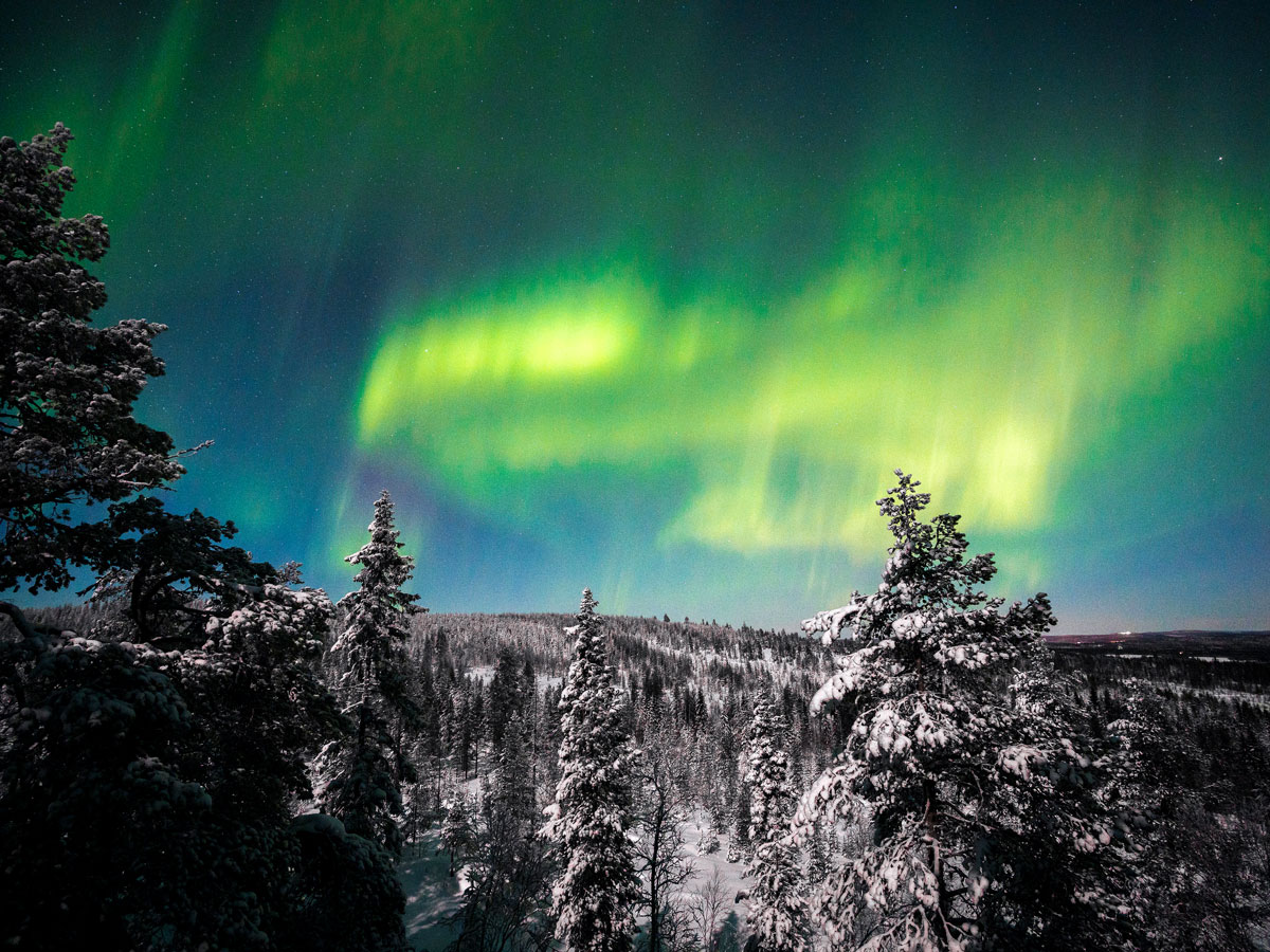
Witnessing the natural wonder of the northern lights (officially known as aurora borealis) is a bucket-list experience for many travelers. This astronomical phenomenon occurs when energetic particles from the sun collide with gaseous particles in the Earth’s atmosphere. When this happens, the particles emit different colors — and since the human eye is most capable of seeing the color green, this is the hue most often associated with the northern lights. But in order to witness this incredible phenomenon, the conditions have to be exactly right. Want to witness this dazzling light show in person? Here are the best places to see the northern lights.
Reykjavík, Iceland, is often called the “Northern Lights Capital of the World” — for good reason. As the northernmost national capital on the planet, Reykjavík often affords visitors the opportunity to spot the arresting green glow of the lights without even leaving the city. However, since light pollution can adversely affect how much you’ll see, booking a northern lights tour to a more isolated location is usually recommended. Auroras are most often spotted from late August to early April in Reykjavík, with the capital city’s coastal areas providing the most expansive views of the mystical sight.
Two important factors make Fairbanks, Alaska, one of the best places in the world to view the northern lights. First, it’s located just beneath the Aurora Oval, an imaginary line that encircles the northern tip of the globe, demarcating the highest concentration of aurora activity. Secondly, the city’s location away from the coast results in low precipitation and a higher number of clear evenings. When the sky is clear, visitors can witness the aurora an average of four out of every five nights during peak season, which runs from August 21 to April 21. As light pollution is one of the biggest hindrances to witnessing the phenomenon, visitors are also encouraged to venture a bit away from the city for optimal viewing. Fairbanks offers a few unique ways to witness the northern lights, including dog sled tours, hot spring resorts, and ice fishing.
Rovaniemi is located just outside the Arctic Circle, which means the northern lights make frequent appearances in this small Finnish city. On average, auroras are reported 150 nights each year, most often materializing in winter, when darkness rules for most of the day. For this reason, winter is considered peak tourist season in Rovaniemi, with many people trekking this far north simply for a chance to witness the near-nightly sky show.
For a chance to see the northern lights within the lower 48, the Upper Peninsula of Michigan may be your best bet. Not only does it sit at a high-enough latitude, but the peninsula also has low light pollution — both of which are important for improving your chances of witnessing the phenomenon. Home to 100 miles of shoreline along Lake Superior, the Upper Peninsula offers plenty of lakeside camping opportunities to get out into the wilderness to see the lights. Pictured Rocks National Lakeshore, for one, provides unrestricted views of the lake and the lights, should they appear. And just across the peninsula over the Mackinac Bridge is Headlands Dark Sky Park, which is also a renowned site for viewing the lights on a clear evening.
Located within the Aurora Oval in northern Norway, Tromsø offers an ideal vantage point for the northern lights for more than half the year. From early September to early April, they can often be spotted within city limits — although for the best show, it’s recommended that you travel away from the light pollution. Tromsø is so far north that it experiences two months of the Polar Night, a period of the calendar year where the sun doesn’t rise at all. On a positive note, these unlit days make it much easier to spot the “night-time aurora,” which is particularly intense and vibrant in this corner of the world.
Lapland, the northernmost province of Sweden, is also located beneath the Aurora Oval and offers many opportunities to see the northern lights. Auroras frequently appear in the fall, winter, and early spring, when this area of Sweden is under a thick blanket of snow. Although the lights can often be seen on clear evenings throughout the region, the lack of light pollution in the town of Abisko provides particularly spectacular viewing of the dancing green light. On a clear night, hop on the chairlift from the town of Abisko to the top of Mount Njullá for one of the surest ways to witness the northern lights in action.
Located in Canada’s Northwest Territories and nearly entirely unspoiled by civilization, Yellowknife is known for electrifying auroras that take over the night sky. Unsurprisingly, the majority of people who travel to this far-flung outpost are in search of these elusive lights. Tours are available through Aurora Village, an Aboriginal-owned company that offers an exclusive experience, including private dining in a teepee, snowshoeing, and multi-day aurora tours.
At the northernmost tip of mainland Scotland is a region known as Caithness, an isolated, historic county known for its dramatic coastline. This remote part of the United Kingdom also happens to be one of the best places to see the northern lights. Situated at a northern latitude of 58 degrees, Caithness is as far north as Stavanger, Norway, and the Alaskan peninsula, making it an ideal location for the lights to appear. In this part of the world, the northern lights are referred to as “Mirrie Dancers,” named for the ways in which the brilliant lights move across the sky.
Advertisement
More from our network
Daily Passport is part of Inbox Studio, an email-first media company. *Indicates a third-party property.
6 Captivating European Border Cities Worth Visiting
By
Daily Passport Team
Read time: 4 minutes
October 12, 2023
Updated: October 12, 2023
6 Captivating European Border Cities Worth Visiting
Geography •October 12, 2023•Updated: October 12, 2023
By Daily Passport Team
Author
Daily Passport Team
Daily Passport writers have been seen in publications such as National Geographic, Food & Wine, CBC, Condé Nast Traveler, and Business Insider. They're passionate about uncovering unique destinations and sharing expert tips with curious travelers.
Most city getaways predictably involve visiting a single country, but border towns are a unique exception — allowing travelers to easily step foot into two different countries on the same visit. Thanks to their locations along territorial lines, these cities offer a fascinating mix of culture and history found in few places around the globe. From the only national capital in the world to border two foreign countries to the glitz and glamor of the French Riviera, explore six captivating European border cities and all they have to offer.
Nestled along the Danube River and surrounded by the Little Carpathian Mountains, Bratislava is the only national capital in the world to border two sovereign countries. The Slovakian capital borders Austria to the west and Hungary to the south. In addition to serving as the political and economic epicenter of its country, the city happens to be a postcard-perfect depiction of old-world Europe — filled with charming cafes, historic architecture, and a pristine hilltop castle (plus, it’s located near plenty of vineyards). Soak up 18th-century vibes with a stop at Primate’s Palace, an ornate dwelling filled with tapestries and period pieces, and check out Michael’s Gate, the only remaining section from the city’s 14th-century fortified walls.
This glitzy coastal city is situated in the south-central ward in the Principality of Monaco, the world’s second-smallest country. The city-state is nicknamed the “Billionaire’s Playground,” thanks to its high concentration of wealth (almost one in three people who live there is a millionaire) and the elite institutions hosted there, such as the Monaco Grand Prix, the Monaco Yacht Show, and the Casino de Monte Carlo. Monaco City (or Monaco-Ville, as locals often refer to it) is the oldest of the four quarters of the city-state, and is where the royal family lives.
The area is often called “The Rock” for its placement on Le Rocher, an elevated headland that projects into the Mediterranean Sea, which adds epic views to this already majestic site. And when you’re ready to cross over into France, there’s even more to explore along the French Riviera — from the hilltop commune of Èze to the promenades of Nice and the vineyards of nearby Provence.
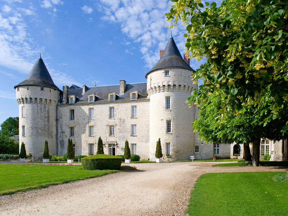
Expect extraordinary views (and plenty of chocolate, bien sur) in this Swiss city, which sits on Lac Léman and is surrounded by the Alps and Jura Mountains. Though a bit farther from the border than other cities on this list, Geneva is still within a 30-minute drive to France’s central-eastern region. That makes for easy trips to culinary hotspots like Lyon or Dijon, though with all of the excitement happening on the Swiss side of the border — from Mont Blanc cable car rides to everyday affairs of the United Nations or Red Cross headquarters — you may decide to stay put.
The third-largest city in Sweden after Stockholm and Gothenburg, Malmö is located in the country’s Skåne province and known for its peaceful parks, waterfront, and cycling paths. (It’s no wonder the city ranked as Sweden’s happiest town.) There’s plenty to do in this charming city, but Malmö is also home to the Øresend, a bridge built in 2000 that connects it to Copenhagen, the Danish capital, in just 20 minutes. (Many residents actually live in one city and work in the other.) For visitors, that’s all good news when faced with decisions of where to shop, eat, and sight-see — both cities are spoiled with options.
Found in the southeast of Limburg, the southernmost region of the Netherlands, Kerkrade is situated alongside Germany’s western border. For centuries, the city served as a vital coal-mining hub, which changed in the 1970s when the mines were closed. Today, the city has plenty of appeal for travelers — especially when it comes to entertainment. Festivals like the World Wind Music Contest and Orlando Festival have put the destination on the map for concertgoers, while other sites — such as the 13th-century Castle Erenstein, zoos including the GaiaZOO and Safaripark Beekse Bergen, a fascinating museum called the Discovery Center Continium, and the Parkstad Limburg Football Stadium — prove there’s a little something for everyone here.
The capital of the region formerly known as Alsace, Strasbourg showcases a marriage of German and French influences, from its architecture to its culture (and, of course, delicious food and wine). Visit the Cathédrale Notre-Dame, once recognized as the tallest building in the world, and ascend its tower for show-stopping views of the city and surrounding Rhine River and Black Forest. There’s perhaps no better time to visit than the holidays, when the town transforms itself into the “Capital of Christmas” — thanks to one of Germany’s most popular outdoor holiday markets, featuring more than 300 stalls across the city center.
Advertisement
More from our network
Daily Passport is part of Inbox Studio, an email-first media company. *Indicates a third-party property.
Geography •October 10, 2023•Updated: October 10, 2023
By Bradley O'Neill
Deserts cover around one-third of Earth’s land surface area. These geographical regions are defined by arid climates where one-of-a-kind ecosystems thrive. While the typical image of a desert is often a vast area of sand and rolling dunes with free-roaming camels, there are in fact five types of desert: subtropical, coastal, rain shadow, interior, and polar deserts. Wondering which of Earth’s deserts are the largest? Read on to discover just how vast the 10 largest deserts in the world are.
10. Great Basin Desert – Nevada and Utah (190,000 Square Miles)
Mainly located in Nevada and Utah, the Great Basin Desert is the largest of North America’s four deserts. This cold desert is framed by the lofty, snow-capped peaks of the Sierra Nevada and Rocky mountain ranges. Within its vast area of nearly 200,000 square miles, the desert contains numerous striking geological formations, from salt flats to ancient lake beds. The Great Basin Desert is also home to many unique flora and fauna, including the bristlecone pine, the Great Basin sagebrush, and the desert tortoise. Within the desert is Great Basin National Park, which attracts visitors with opportunities for stargazing, hiking to the summit of 13,063-feet Wheeler Peak, and discovering stalactites and stalagmites within the Lehman Caves.
9. Rub’ al-Khali – Arabian Peninsula (250,000 Square Miles)
Sprawling across parts of Saudi Arabia, Oman, Yemen, and the UAE on the Arabian Peninsula, Rub’ al-Khali is characterized by enormous, shifting dunes. This is the largest area of continuous sand in the world and also one of Earth’s driest places. Often called the “Empty Quarter,” Rub’ al-Khali is virtually uninhabited and, for the most part, remains unexplored. The Indigenous Bedouin peoples have historically traversed the dunes in search of riches, although there’s no permanent human settlements. (That said, according to legend, there is a buried lost city called “Atlantis of the Sand.”) Visitors to Rub’ al-Khali can camp beneath the stars in complete solitude and live out scenes captured in movies such as 2015’s Star Wars: The Force Awakens, which was filmed here.
8. Great Victoria Desert – Australia (250,000 Square Miles)
The Great Victoria Desert stretches across the states of Western Australia and South Australia with a landscape of sand dunes, shrublands, and acacia and eucalyptus woodlands. For millennia, this has been the sacred lands of Indigenous Australian groups such as the Pintupi and Pitjantjatjara. British-born Australian explorer Ernest Giles visited the area in 1875 and named it after Queen Victoria.
The arid region provides a natural habitat for over 100 species of reptiles, including geckos, goannas, and elapid snakes. The desert also shelters nine endangered plant species, 10 threatened mammals, and four threatened bird species. A popular route through the Great Victoria Desert travels from the town of Leonora along the Great Central Road to the famous Uluru rock formation (formerly called Ayers Rock).
7. Patagonian Desert – Argentina (260,000 Square Miles)
Occupying almost the entire southern portion of mainland Argentina, the Patagonian Desert is a semi-arid steppe and desert. It’s bordered by the majestic Andes mountains to the west and the Atlantic Ocean to the east. Topographically diverse, the desert is made up of everything from tablelands and canyons to river valleys, forests, and glacial lakes. They provide habitats for varied wildlife such as birds of prey, desert iguanas, guanacos, and Patagonian gray foxes. Trekking and glacier walking in Los Glaciares National Park are popular activities in the desert, as are boat tours and rafting in Nahuel Huapi National Park.
6. Kalahari Desert – Southern Africa (360,000 Square Miles)
One of two African deserts to make the list, the Kalahari Desert is a far-reaching sandy savannah that stretches south from Angola through sections of Namibia, Botswana, and South Africa. Comprising the largest ecosystem in Botswana, the Kalahari Desert is fed by the waters of the Okavango Delta, the world’s largest inland delta. The San (Bushmen), who have called the desert home for over 20,000 years, are Indigenous hunter-gatherer peoples who are thought to be the oldest residents of southern Africa.
Today, visitors to the Kalahari Desert come for the chance to spot majestic animal species, including lions, cheetahs, elephants, onyx, and gemsbok. Among the best places to do so are Botswana’s Central Kalahari Game Reserve and South Africa’s Kgalagadi Transfrontier Park.
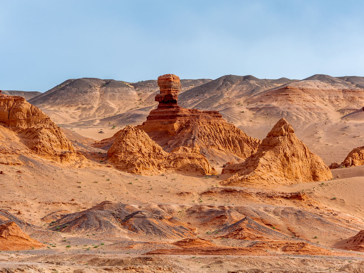
5. Gobi Desert – China and Mongolia (500,000 Square Miles)
Asia’s second-largest desert straddles the border of Mongolia and northeastern China. This rain shadow desert sits between the Himalayas and icy Siberian steppes and is made up of a predominately rocky landscape. Only around 5% of the desert is sand, although this includes the Khongor Sand Dunes, which reach up to 260 feet tall and 112 miles long. Historically, the region was the location for important stops on the ancient Silk Road. It’s also scattered with religious monuments such as the Mogao Caves in Dunhuang, China — a UNESCO-protected Buddhist complex featuring almost 500 cave temples and thousands of murals. Another notable site within the desert is Mongolia’s Flaming Cliffs, where some of the first fossil dinosaur eggs were discovered in the 1920s.
4. Arabian Desert – Middle East (900,000 Square Miles)
The mystical Arabian Desert stretches all the way from Iraq to Yemen and the Persian Gulf, with the largest section lying within Saudi Arabia. Known for extreme temperatures, it boasts a dramatic landscape of golden sands, salt flats, limestone cliffs, and mountains. Amid this inhospitable region, acacia trees, date palms, roses, and other plant species thrive. Wildlife includes gazelles, oryx, sand cobras, and migratory birds. A cradle for Arabian culture, the desert is a fascinating showcase of the old and new. Jordan’s ancient carved-rock city of Petra and the modern metropolis of Dubai are two places where this contrast is most visible.
3. Sahara Desert – Northern Africa (3.32 Million Square Miles)
The Sahara Desert is the world’s largest hot desert. This subtropical desert extends into 10 African countries situated between the Red Sea and the Atlantic Ocean. The Bedouin, Berber, and Tuareg peoples also live within the sand dunes, savannahs, and rocky plateaus of the region. Some 500 plant and 70 mammal species flourish here, including the Sahara’s emblematic camels and desert foxes. Visitor highlights include Egypt’s 13th-century Shali Fortress and White Desert National Park, Chad’s Zakouma National Park, and Morocco’s Todra Gorge.
2. Arctic Polar Desert – Arctic Circle (5.3 Million Square Miles)
The world’s second-largest desert is one of only two polar deserts located on the planet. Cold, windy, and unforgiving, the Arctic Desert spreads over three continents and eight countries: Canada, Greenland, Iceland, Norway, Sweden, Finland, and Russia. While snow is found here, it very rarely melts thanks to the region’s extremely low temperatures.
Despite this, roughly 1,700 plant species thrive in the Arctic tundra. They are typically short root plants, which is why trees are uncommon. Animal species include the Arctic fox and wolf, caribou, polar bear, and snowy owl. If they can make the trek, travelers will find plenty of highlights throughout this polar region — Canada’s Ellesmere Island, Greenland’s Northeast Greenland National Park, and Norway’s Lofoten archipelago are all found here.
1. Antarctic Polar Desert – Antarctica (5.39 Million Square Miles)
The Antarctic Polar Desert covers the entire continent of Antarctica. Among Earth’s coldest, driest, and windiest locations, the desert also encompasses the South Pole. There’s no rain or snow here, but there are iceberg-flanked passageways and endless miles of thick ice sheets, some of which reach heights of over 13,000 feet.
The region is also known for peaks called nunataks, which rise above ice sheets. The desert’s McMurdo Dry Valley is the only recognized place in the world devoid of microbial life. While the Antarctic Polar Desert may be extremely remote, it’s still possible to visit: A popular excursion sets sail from Ushuaia, Argentina, on a journey via the infamous Drake Passage.
Advertisement
More from our network
Daily Passport is part of Inbox Studio, an email-first media company. *Indicates a third-party property.
7 Must-Visit Historical Sites in the Pacific Northwest
By
Jersey Griggs
Read time: 5 minutes
October 10, 2023
Updated: October 10, 2023
7 Must-Visit Historical Sites in the Pacific Northwest
History •October 10, 2023•Updated: October 10, 2023
By Jersey Griggs
Author
Jersey Griggs
Jersey is a travel and lifestyle writer whose work has appeared in publications such as Condé Nast Traveler, Business Insider, and Bust. When she’s not exploring her adopted home state of Maine, she’s likely planning her next big trip.
With its rugged coastlines, soaring mountains, and old-growth forests, the Pacific Northwest (PNW) is famous for its remarkable natural beauty. But the PNW’s diverse landscapes aren’t the only draw — this region (which includes the states of Idaho, Oregon, and Washington) is filled with fascinating history. From the oldest courthouse in the West to a ship that once served as a floating lighthouse, here are seven historical sites you shouldn’t miss the next time you’re in the Pacific Northwest.
Downtown Portland’s Pioneer Courthouse is the oldest standing federal building in the Pacific Northwest. Completed in 1875 at a cost of $396,500 (equivalent to over $11 million today), the impressive Italianate-style building occupies a full city block. At one point, the courthouse was scheduled to be demolished — fortunately, it has since become a National Historic Landmark.
Today, the historic courthouse is situated across from the Pioneer Courthouse Square, a 40,000-square-foot park affectionately known as “Portland’s Living Room.” Although the courthouse has undergone several rehabilitations since it was first built, the building still retains original architectural details, such as the grand stairway in the lobby and decorative plaster molding.
Fort Nisqually Living History Museum – DuPont, Washington
The Fort Nisqually Living History Museum takes visitors back to life in the Pacific Northwest during the mid-19th century. The museum is a restoration of the first European settlement in Washington state, which was established as a British fur trading post in 1833 by the Hudson’s Bay Company. The fort was once a thriving business center and meeting place for colonial settlers, merchants, and the Indigenous peoples of the region.
Today, the Living History Museum allows visitors to experience territory life during the 1800s with daily tours, hands-on exhibits, and specialty workshops. With staff dressed in period clothing and live demonstrations of 19th-century crafts, the museum is dedicated to showcasing Fort Nisqually’s diverse history.
Burial Site of Chief Seattle – Suquamish, Washington
The only major U.S. city named for a Native American, Seattle’s appellation is derived from Chief Si’ahl, the leader of the Suquamish and Duwamish people in the 1800s. Known to settlers as “Chief Seattle,” Si’ahl was a compelling orator who worked to ensure the Indigenous cultures coexisted peacefully with European settlers.
Today, his burial site can be visited in the town of Suquamish on the Kitsap Peninsula, reachable via a ferry from the Bainbridge Island Ferry Terminal in Seattle. A Catholic convert, Chief Seattle is buried behind St. Peter’s Catholic Mission, on what has now been designated as Suquamish land. To learn more about the region’s Indigenous culture, stop by the Suquamish Museum before walking to the gravesite, which is honored by the Suquamish Tribe every third week in August during Chief Seattle Days.
Jacksonville Historic District – Jacksonville, Oregon
After gold was discovered in southwestern Oregon’s Rich Gulch in 1851, miners flocked to the area with hopes of striking it rich. Westward settlers were also drawn to Oregon with the promise of free land, and before long the boom town of Jacksonville sprung up, eventually growing into one of the territory’s largest cities.
Today, the entire town of Jacksonville has been designated as a National Historic Landmark. Ride on the Trolley Tour to learn about Jacksonville’s humble beginnings as a mining camp and to see the many historic homes built during the 18th and 19th centuries. To explore Jacksonville on foot, the Haunted History Tour highlights the town’s most historic buildings, while also sharing stories of the spirits who supposedly haunt them.
Point Wilson Lighthouse and Fort Worden Historical Park – Port Townsend, Washington
Situated on the tip of a peninsula in Port Townsend, the Point Wilson Lighthouse was built in 1914 to mark the entrance to the Admiralty Inlet. At 51 feet in height, it is the tallest beacon on Puget Sound. The lighthouse is still in operation today, serving as an important navigational aid that guides ships on the Sound and the Strait of Juan de Fuca.
The lighthouse is located within Fort Worden Historical Park, itself a historical gem on Puget Sound. The former military base is home to wide lawns, artillery bunkers, and centuries-old Victorian homes that once housed officers. Overnight camping is permitted on the park’s beach, while more comfortable accommodations can be booked in one of the park’s 36 historic house rentals.
Located within the Columbia River Maritime Museum, the Lightship Columbia is an incredible piece of Oregon’s maritime history. For 28 years, the ship functioned as a floating lighthouse on the mouth of the Columbia River. The ship was home to a crew of 17 men who helped to guide other ships along the dangerous passageway. Today’s visitors are allowed to climb aboard the historic ship to learn how the crew lived and worked on the vessel between 1951 and 1979.
The museum’s other exhibits include a 3-D theater, a full-sized fishing trawler, and a pond for launching model boats. A highlight is the exhibit on the Columbia River Bar, considered to be one of the most treacherous passages in the world, where approximately 2,000 ships have been sunk since 1792.
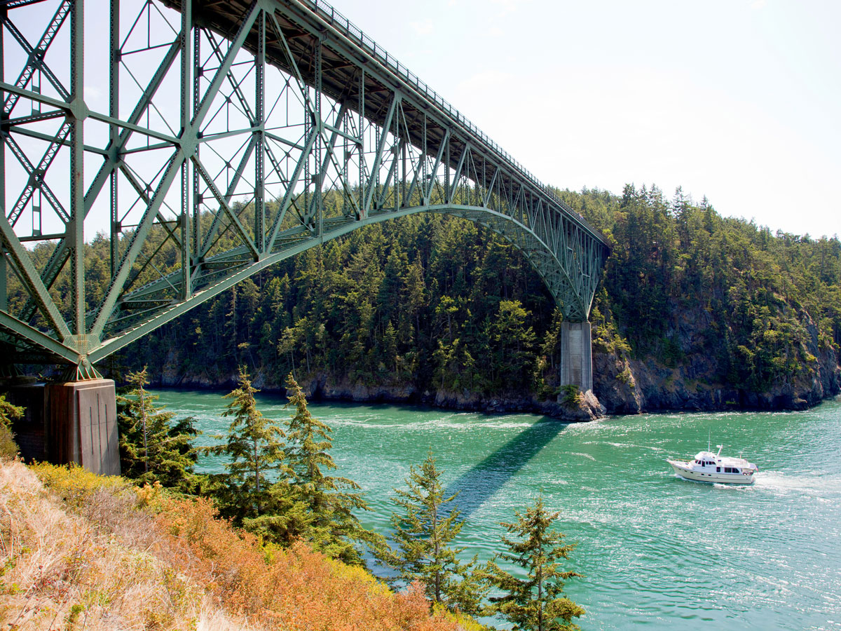
The narrow waterway that connects the Strait of Juan de Fuca and Skagit Bay is known as Deception Pass — named from the deceptively swift and dangerous tidal currents that run between Whidbey and Fidalgo Islands. The bridge above the pass was built by the state of Washington as part of the Civilian Conservation Corps, a Depression-era public works program.
On the day Deception Pass Bridge opened in 1935, approximately 700 cars traveled on it. Today, 20,000 cars journey over the bridge daily, often through the thick fog for which the Pacific Northwest is known. Those who cross the 180-foot-high bridge are treated to unparalleled views of the rocky headlands and the surrounding state park. Foot traffic is also permitted on the bridge, with tours which aim to explore the region’s exceptional beauty and impressive history.
Advertisement
More from our network
Daily Passport is part of Inbox Studio, an email-first media company. *Indicates a third-party property.
Geography •October 10, 2023•Updated: October 10, 2023
By Bennett Kleinman
Author
Bennett Kleinman
Bennett is a New York City-based staff writer for Daily Passport. He previously contributed to television programs such as the Late Show With David Letterman, as well as digital publications like the Onion. Bennett has traveled to 48 U.S. states and all 30 Major League Baseball stadiums.
There are seven countries in the world whose names end with the suffix -stan: Afghanistan, Kazakhstan, Kyrgyzstan, Pakistan, Tajikistan, Turkmenistan, and Uzbekistan. In Persian and Urdu, -stantranslates to “place of” or “where one stands.” That makes the literal names of these Central Asian countries “place of the Afghans” or “places of the Tajiks,” for example. But despite their similar names, these independent states each have their own unique history and culture that make them distinct. Here are seven fascinating facts about the “-stan” countries.
Uzbekistan Is One of Two Doubly Landlocked Nations
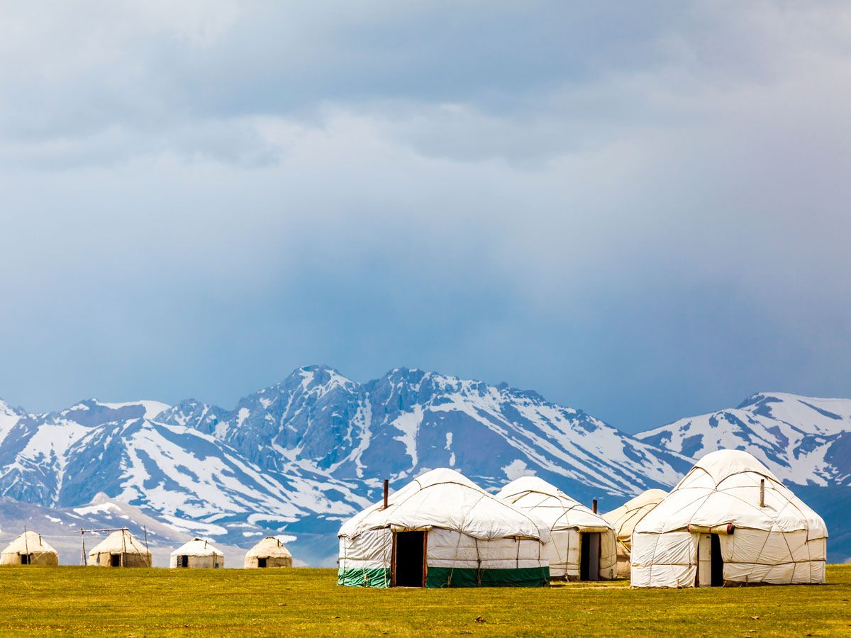
There are 44 landlocked countries in the world (the largest of which is Kazakhstan), but Uzbekistan is one of only two doubly landlocked nations (along with Liechtenstein). In Uzbekistan’s case, this means that all the countries surrounding it — Afghanistan, Kazakhstan, Kyrgyzstan, Tajikistan, and Turkmenistan — are also landlocked.
The Uzbekistan region wasn’t always landlocked, but that changed after gaining independence from the Soviet Union in 1991. Some geographers argue that the neighboring countries of Kazakhstan and Turkmenistan aren’t actually landlocked since they touch the Caspian Sea, but most classify the Caspian Sea as a large lake instead of a sea, as its name would suggest. Because of its unique geography, Uzbekistan is deeply reliant on its neighboring countries for access to trade, and the nation has joined the Eurasian Economic Community to help maintain strong trading relations.
Afghanistan Is Home to the World’s Oldest Oil Paintings
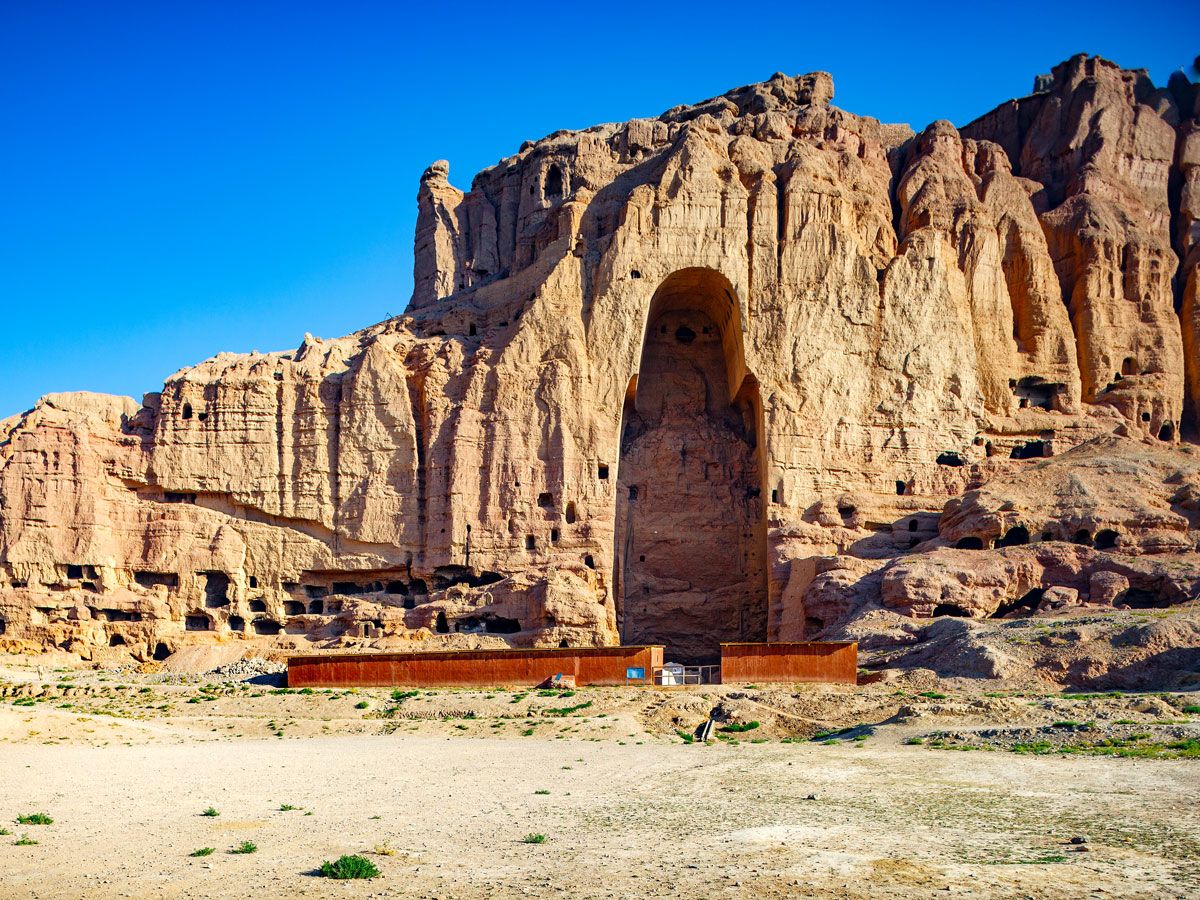
In 2008, archaeologists uncovered a series of murals located throughout caves in Afghanistan’s Bamiyan Valley. A UNESCO World Heritage Site in itself, the Bamiyan Valley was once home to thriving Buddhist sanctuaries. The Buddhists who inhabited the region painted these vast murals, and of the 50 caves examined, 12 contained evidence of oil-based paints. This evidence led the archaeologists to determine the works to be the world’s oldest known oil paintings, dating to around 650 CE.
These ancient paintings depict Buddhists sitting cross-legged and dressed in vermilion robes, alongside various creatures such as crouching monkeys and mythical beasts intertwined with palm leaves. The oil used to create these paints is believed to have been produced from walnuts or poppy seeds. What makes this discovery all the more groundbreaking is that oil wasn’t incorporated into European paint until the 13th century, long after these paintings were created.
Astana, Kazakhstan, Holds the Record for Most Name Changes by a Capital City
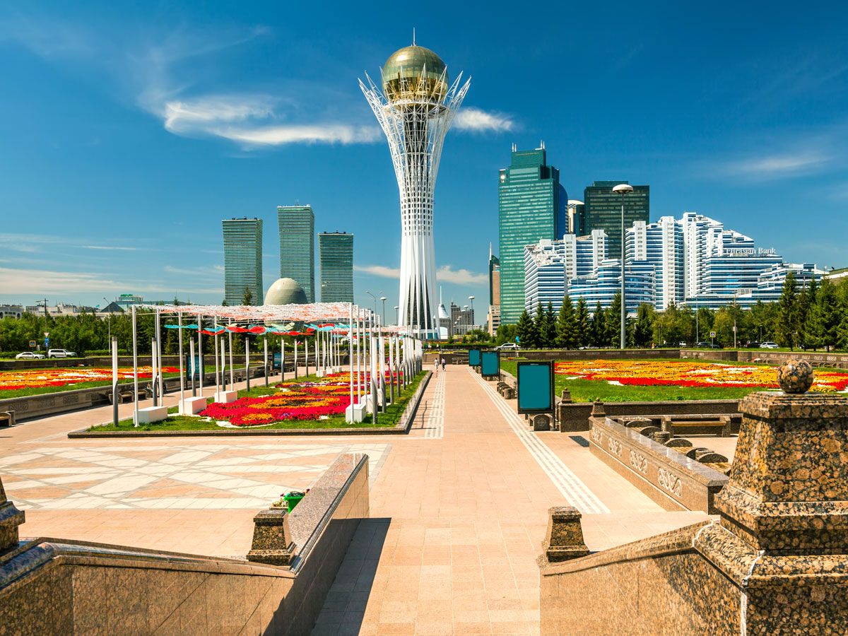
Kazakhstan’s capital city, which is currently called Astana, holds the Guinness World Record for most name changes by a capital city (though it’s only served as the country’s capital since 1997). The city was founded as a Russian military outpost in 1830 known as Akmolinsk, meaning “white holy place.” After joining the Soviet Union, its name was changed in 1962 to Tselinograd, which translates to “virgin lands city” and reflected unprecedented Soviet expansion into the Steppe region.
After gaining independence from the U.S.S.R. in 1991, the city’s name was again changed to Aqmola, translating to “white grave.” Six years later, the Kazakh government transferred the country’s capital from Almaty to its current location, and changed the city’s name to Astana (“capital”). In 2019, the city’s name was altered yet again to Nur-Sultan in honor of Nursultan Nazarbayev, who served as Kazakhstan’s president from 1991 to 2019. But in September 2022, the city’s name reverted back to Astana.
The Longest Poem in History Was Written in Kyrgyzstan
The Epic of Manas, a Kyrgyz poem about a warrior hero and his descendents, is around 530,000 lines long, with certain versions reaching over 1 million lines depending on who’s reciting it. That makes it 20 times longer than Homer’s Greek epic, the Odyssey. The first part of this three-part tale centers around Manas, whereas the second part focuses on his son, Semetey, and the third part covers his grandson, Seytek.
The tale was originally part of the Kyrgyz oral tradition, though it was finally recorded in the 19th century. The first complete published version was released in the 1920s, and a popular version recorded between 1922 to 1926 by performer Sagymbay Orozbakov is now considered the fullest version available. This indelible work was enshrined on UNESCO’s Intangible Cultural Heritage List in 2009.
Pakistan Contains the World’s Highest International Paved Road
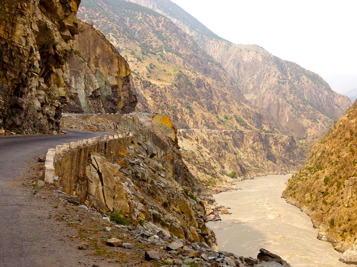
The Karakoram Highway runs for 810 miles from Abbattabad, Pakistan, through the Karakoram mountain range to Kashgar, China — with around 68% of its total length located on the Pakistani side. At its highest point, the highway reaches a peak elevation of 15,466 feet above sea level, making it the highest international paved road on the planet.
While the road is open year-round, the particularly treacherous Khunjerab Pass — located at 15,397 feet above sea level — is closed from January through April each year due to heavy snowfall. Construction began on the Karakoram Highway in 1959, and it finally opened to the public in 1986. Over the years, the roadway’s width has been expanded threefold, and it is now capable of accommodating heavier vehicles and travel during more perilous weather conditions.
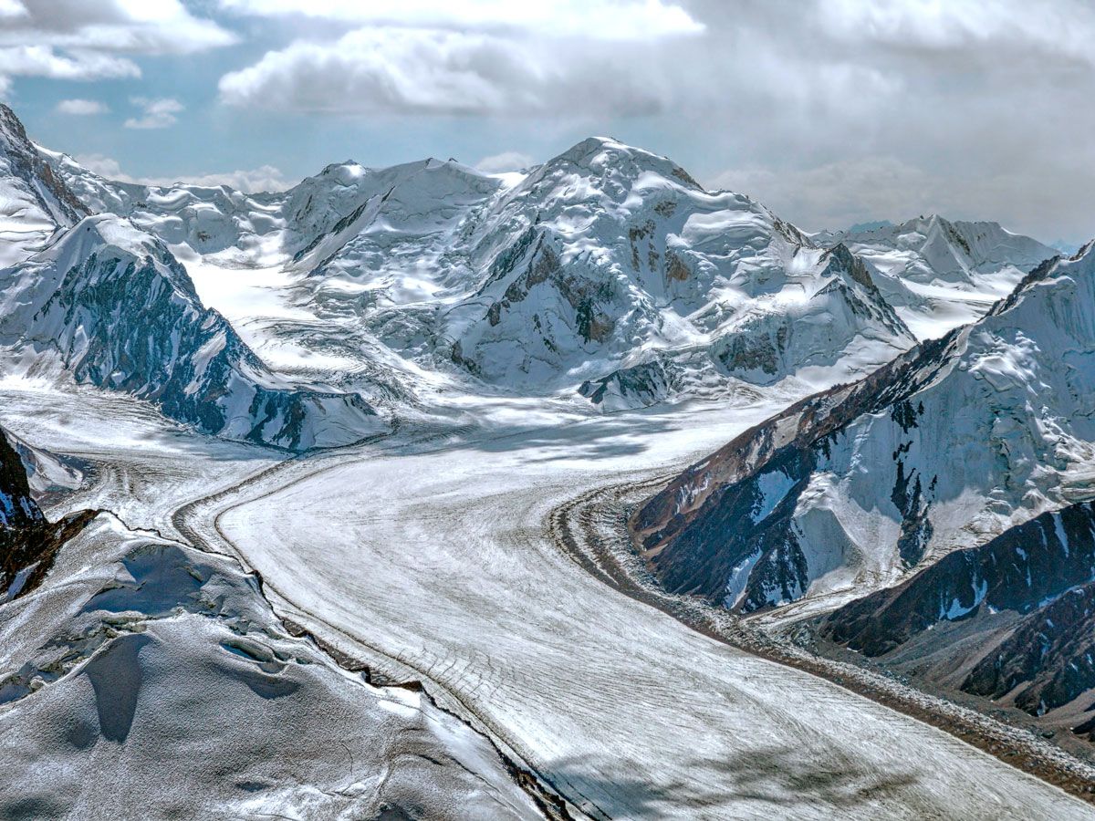
Tajikistan Is Home to the World’s Longest Non-Polar Glacier
Tajikistan’s Fedchenko Glacier is the largest glacier found outside of the Earth’s polar regions. This massive block of ice — which measures 47 miles long and covers 350 square miles of area — was discovered in 1878 and named for Russian explorer A.P. Fedchenko. However, it wasn’t until 1928 that the glacier’s middle and upper reaches were finally explored on more thorough expeditions.
The Fedchenko Glacier begins at an elevation of 20,300 feet in the Pamir Mountains, and it drops a whopping 8,200 feet throughout its course. The glacier melts into the nearby Muksu, Vakhsh, and Amu Darya rivers, which feed the Aral Sea and provide Central Asia with a critical water supply. Due to increasing temperatures, the glacier has shrunk by 4,600 feet since 1933, though it remains the largest non-polar glacier anywhere on the planet.
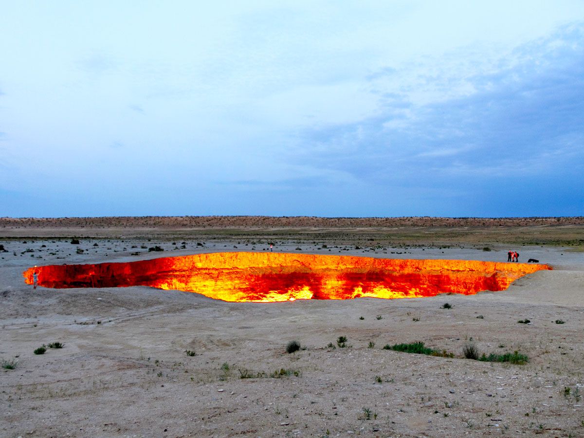
There’s a Continuously Burning Crater in Turkmenistan
Nicknamed the “Door to Hell,” the Darvaza Crater formed in 1971 when the ground beneath a Soviet drilling operation in Turkmenistan gave way. The fiery 230-foot-wide and 65-foot-deep crater has been continuously burning ever since, standing out against the otherwise barren landscape of the Karakum Desert. However, some geologists believe that the actual crater may have formed in the 1960s, and ignited two decades later.
However it may have initially formed, its glowing embers light up the night sky from miles away, and the crater has become a popular tourist attraction that brings many visitors right up to its rim. However, the crater may not be around much longer: In January 2022, President Gurbanguly Berdymukhamedov ordered that research be done on how to potentially extinguish the crater’s flames.
Advertisement
More from our network
Daily Passport is part of Inbox Studio, an email-first media company. *Indicates a third-party property.
Climb to the Top of These Famous Staircases Around the World
By
Fiona Mokry
Read time: 8 minutes
October 10, 2023
Updated: August 16, 2024
Climb to the Top of These Famous Staircases Around the World
Architecture •October 10, 2023•Updated: August 16, 2024
By Fiona Mokry
Author
Fiona Mokry
Fiona has spent her career exploring the world and working in the travel industry, turning her lifelong passion into a profession. From planning custom trips to sharing stories as a travel writer for publications such as The Discoverer, she’s all about helping others experience the world in a deeper, more meaningful way.
Staircases are found all over the planet, but not all staircases are run-of-the-mill. Some come with a long and complex history, while others became famous for their appearances in Hollywood films. Some are just as architecturally spectacular as the museums and monuments in which they are found. These are 11 famous staircases you should seek to climb on your travels.
Guatapé is a small, colorful town located 50 miles west of Medellín, making it a popular day trip or weekend destination for those seeking a slower pace. The town is famous for its bright facades (known as zócalos) painted on the sides of homes and storefronts, but, most of all, for El Peñón de Guatapé, a 650-foot rock that towers above everything else.
A brick staircase with 740 steps is embedded into a large crack that runs the height of the rock, transporting climbers in a zigzag fashion all the way to the peak. On average, the climb to the summit takes about 30 minutes. But those efforts will certainly pay off — at the top, you’ll be rewarded with panoramic views of the expansive lake system and rolling emerald hills surrounding Guatapé.
Don’t let the name confuse you — the Spanish Steps are actually in Rome, Italy. So how did this famous landmark get its name? Connecting the Piazza di Spagna (Spanish Square) to the Trinità dei Monti, a spectacular Renaissance church, the 135-step staircase is known as the Scalinata di Trinità dei Monti in Italian. Its English name, the Spanish Steps, comes from the original location of the Spanish Embassy in the Piazza di Spagna in the 17th century. (And to make matters more confusing, the stairs were commissioned by a French diplomat.)
Built between 1723 and 1725, the ornate staircase is a true Baroque masterpiece. The steps’ central location in Rome makes them an essential stop on the tourist agenda, and they are a beloved and picturesque spot for locals and visitors alike to hang out.
Machu Picchu, Peru’s most-visited tourist attraction, sits on a high ridge in the Andes Mountains as a stunning example of 15th-century Inca engineering. Visitors come to admire its well-preserved temples and palaces, alongside epic views of the surrounding peaks. The trek to Machu Picchu takes days, and the feat isn’t over until the so-called “Stairs of Death” are conquered.
The staircase, carefully carved into the mountain, ascends to the summit of Huayna Picchu, offering a breathtaking vantage point overlooking the ancient city of Machu Picchu. With 1,000 steep and challenging steps, the climb demands a high level of fitness and agility. However, the stunning panoramic views from the top are the reward for those who complete this exhilarating climb.
The steps at the foot of the Philadelphia Museum of Art rose to fame following their Hollywood debut in the 1976 classic film Rocky. The scene — in which the titular character (played by Sylvester Stallone) powers up the museum’s staircase during his boxing training — served as inspiration for underdogs everywhere. The bronze Rocky statue that was built for scenes in the sequel Rocky III sits at the bottom of the steps and is a popular spot for visitors to snap a photo. Even if you’re not a Rocky fan, the view of Philadelphia from the top of the stairs is one of the best in the city.
The Pio-Clementino Museum in Vatican City houses some of the world’s most prized artworks. However, it’s not just the paintings and statues that catch the eye of art lovers: The museum is also famous for its stunning Bramante Staircase. There are actually two staircases with this name — the original, built in 1505, and the modern one, designed by Giuseppe Momo in 1932.
The original Bramante Staircase follows a double helix design and was built for Pope Julius II. Unfortunately, that staircase is closed to the public, but the modern version — designed to mimic the original — is open to museumgoers today. It’s quite a sight to stand at the top of the stairs and watch the people below snake their way to the bottom of the seemingly never-ending spiral.
Sanctuary of Bom Jesus do Monte – Tenões,Portugal
Credit: LuisPinaPhotogrpahy/ iStock via Getty Images Plus
This 18th-century Catholic shrine in Tenões, in northern Portugal, is a major pilgrimage destination for Christians. A UNESCO World Heritage Site, it is also one of the most significant religious and architectural landmarks in Portugal. Along with its gleaming white plaster facades and exposed stonework, the sanctuary’s most famous feature is the celebrated Sacred Way staircase.
The 579 stairs — broken into three distinct staircases called the Pórtico staircase, Three Virtues Staircase, and Five Senses Staircase — zigzag sharply to the pinnacle of the complex, where the church and gardens sit atop a hill. The staircase is adorned with statues, fountains, and intricately carved columns. While pilgrims traditionally climb the stairs on their knees during Holy Week, visitors are welcome to walk the stairs or take the funicular to the top for the panoramic views over nearby Braga and the Portuguese countryside.
It’s a tall task to pick a standout element in a place as grand as Angkor Wat — the world’s largest religious structure — but the steep steps attached to the exterior of the temple are a worthy contender. Leading up to the top of Angkor Wat’s tower are three sets of staircases that become increasingly steep as they ascend. The third set of stairs is set at a 70% incline, purposely built to represent the difficulty of reaching the kingdom of the gods. It’s one of the world’s steepest staircases, but your reward for trudging to the top is an epic view over the temple and the rest of Angkor, which was the seat of the Khmer kingdom from the ninth to 15th centuries.
Tiger & Turtle Magic Mountain – Duisburg,Germany
Credit: ThomasSaupe/ iStock Unreleased via Getty Images
This art installation in Duisburg, Germany, resembles a roller coaster but invites visitors to explore its twisting paths on foot rather than by motorized cart. Created by artists Heike Mutter and Ulrich Genth in 2011, Tiger & Turtle was built upon a slag pile within Angerpark, an urban park in northern Duisburg, a region known for its steel industry and bustling inland port. Today, efforts have been taken to transform the area into a cultural hub through art installations.
Tiger & Turtle stands 69 feet tall, and its 249 steps twist into looped paths that offer unique views of the Rhine River and Düsseldorf, along with contrasting views of the bustling steel factory on one side and a dense forest on the other. The modern “mountain” is especially attractive at night, when it’s lit up with 880 LED lights.
To reach the stairs of Heaven’s Gate — located in the Tianmen Mountains in the northwest of China’s Hunan province — visitors must first take a 30-minute ride on the Tianmen Mountain Cableway to climb the 4,000 feet to the base of the stairs. Looming above the base are the 999 steps to the top of Tianmen Cave, popularly known as the “Gateway to Heaven.” The number is purposeful: As the highest single digit, the number nine represents eternity and longevity in Chinese numerology. Centuries ago, one side of the cave collapsed, leaving what now appears to be an actual door to the heavens above. Measuring 430 feet tall by 190 feet wide, and sitting roughly 5,000 feet above sea level, Tianmen Cave is the highest naturally formed arch in the world.
Chand Baori – Abhaneri, India
Credit: momo11353/ iStock via Getty Images Plus
Located in the village of Abhaneri in the Indian state of Rajasthan, Chand Baori is a stepwell that extends roughly 100 feet into the ground, making it one of the deepest and largest of its kind. Stepwells were commonly built in India for centuries, particularly in arid regions, to provide access below the water table for drinking and agriculture. Chand Baori was built in the eighth century and named after a local ruler, Raja Chanda.
The stepwell features 3,500 steps arranged in intricate, yet functional geometric patterns, leading down to a still pool of water at the bottom. There was once a palace built around Chand Baori; however, these rooms are not accessible to visitors today. But visitors can walk down the steps and notice how the temperature drops by about 5 to 6 degrees Fahrenheit at the bottom of the well. As a proven way to beat the heat, stepwells continue to be popular gathering spots and cool retreats for locals centuries later.
Batu Caves – Selangor, Malaysia
Credit: R.M. Nunes/ iStock via Getty Images Plus
The Batu Cavesare tucked within a towering limestone rock in Selangor, located 8 miles north of the Malaysian capital of Kuala Lumpur. The popular tourist attraction and significant religious site is one of the most-visited places in the capital region. To access the cave system, visitors must climb 272 concrete steps. The base of the staircase is marked by a massive golden statue of the Hindu deity Lord Murugan, which, at 140 feet, is the tallest statue in Malaysia. The wide, painted steps ascend to the main cave, known as Temple Cave, which houses several Hindu shrines and statues.
Another popular cave to visit within the Batu Caves complex is the Museum Cave, featuring exhibits on Hindu art, culture, and history. Meanwhile, Art Gallery Cave displays Hindu sculptures and paintings, and Ramayana Cave showcases depictions of scenes from the Hindu poem “Ramayana” through colorful statues and murals.
Advertisement
More from our network
Daily Passport is part of Inbox Studio, an email-first media company. *Indicates a third-party property.
History •October 10, 2023•Updated: February 26, 2025
By Daily Passport Team
Author
Daily Passport Team
Daily Passport writers have been seen in publications such as National Geographic, Food & Wine, CBC, Condé Nast Traveler, and Business Insider. They're passionate about uncovering unique destinations and sharing expert tips with curious travelers.
They say imitation is the best form of flattery, and the same notion rings true when it comes to place names. While the names of U.S. cities and towns have a diverse set of influences — some come from Indigenous cultures, some are named after European royals, and so on — many others are based on cities that already existed abroad. Here are 15 fascinating U.S. cities and towns that have enthusiastically adopted the name of another place in a foreign country.
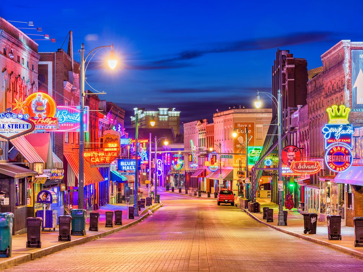
Egyptian city names in America aren’t very common, but Tennessee’s second-largest city is a notable exception. With its neon lights and blues music on every corner, Memphis, feels a world away from its ancient Egyptian namesake. The Tennessee city was built thousands of years after Memphis, Egypt, was abandoned, but both cities have one thing in common: They are constructed alongside great rivers. It’s not certain why the three men (including future President Andrew Jackson) who founded the Tennessee city named it after the one in Egypt, but perhaps they felt the Mississippi River evoked the spirit of the Nile and the prosperous trading and temple city built on its banks.
Modern Memphis is known throughout the world for its music scene. Elvis Presley built Graceland on the city’s outskirts, and Sun Studios, the birthplace of rock ‘n’ roll, is steps away from Beale Street. While there aren’t many obvious similarities with the ruined city on the banks of the Nile, there is one big homage to its Egyptian connection: the Memphis Pyramid.
With warm temperatures and nearby beaches, you might be forgiven for mistaking this Florida city with its Australian namesake. But it’s not the geographical similarities that led to this city being named after the Melbourne Down Under.
The area around the Indian River Lagoon began rapidly developing in the late 19th century, and a post office became necessary to serve the community. The settlement needed a name. The area’s inhabitants found inspiration in the town’s first postmaster, Cornthwaite John Hector, who had spent many of his formative years in Melbourne, Australia. (However, it wasn’t Hector who proposed calling the settlement Melbourne; a local woman suggested it.) On December 23, 1888, straws were drawn to select a new name, and Melbourne won.
Today, this harbor city retains many historic Victorian wooden houses that wouldn’t look out of place in Melbourne, Australia. Take a stroll into the charming downtown to admire its tropical murals, browse independent shops, or try a Florida seafood boil on Main Street.
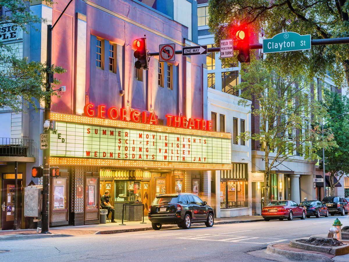
Like its European counterpart, Athens, Georgia, is a center of academia, culture, and the arts. The University of Georgia — the first public land-grant university in the U.S. — was founded here in 1785. After classes began in 1801, a burgeoning city sprang up around campus. In 1806, the city was incorporated, and the Georgian governor at the time, John Milledge, suggested the name Athens, as the Greek capital was home to Europe’s earliest intellectuals, including revered philosophers Plato and Aristotle.
Today, the 19th-century Greek Revival buildings in the city center, including the Taylor Grady House, remind visitors of the Parthenon everywhere they look. And, like its Greek counterpart, Athens, Georgia, enjoys a thriving student scene — you can’t miss the music of up-and-coming indie bands emanating from the campus town’s trendy bars and restaurants.
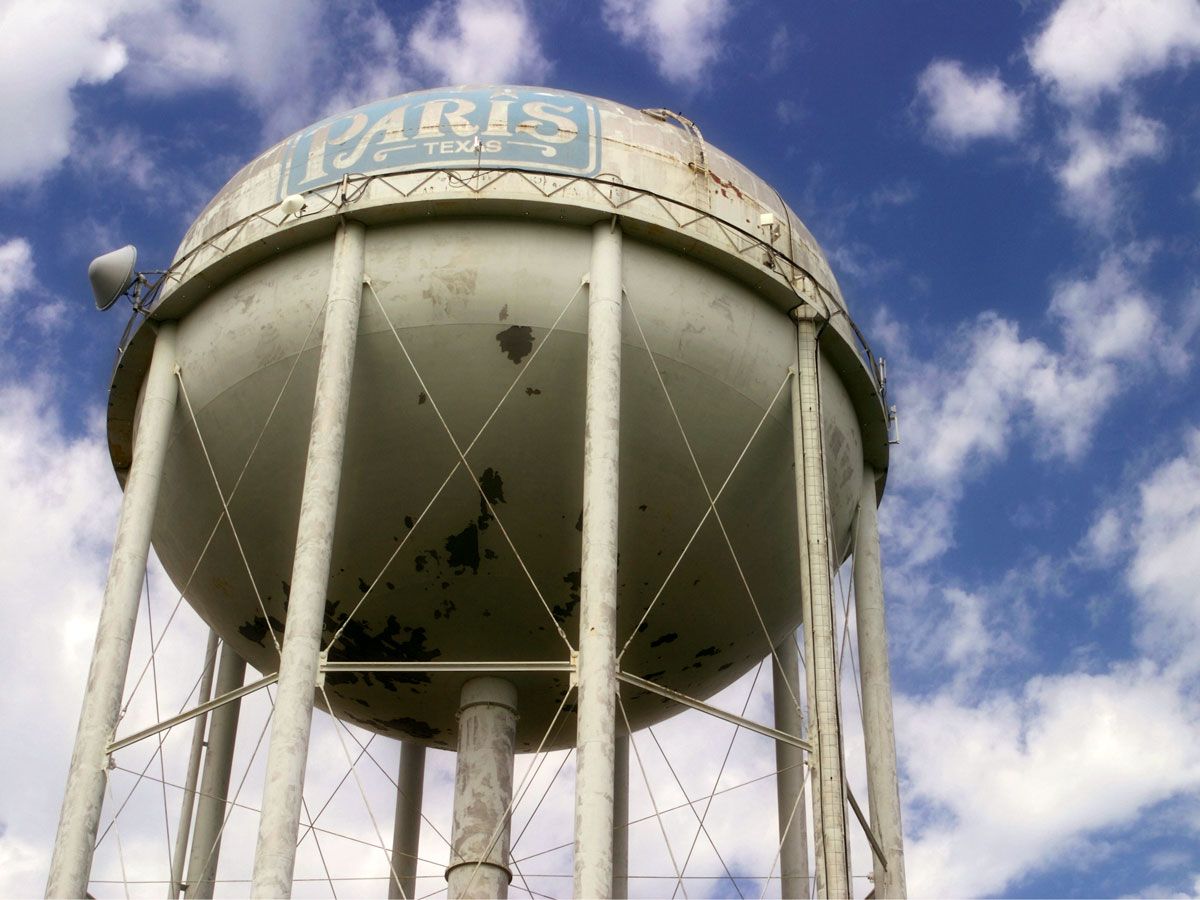
A railroad boom town on the northern edge of the Lone Star State, Paris, Texas, is arguably the most famous of all America’s towns named after the chic French capital — indeed, locals call it “the second-largest Paris in the world.” But no one is exactly sure why the two cities share a name.
Popular belief is that an employee of the town’s founder, George Washington Wright, came up with the idea when the town was incorporated in 1844. The employee, Thomas Poteet, lobbied to call the new town Paris in honor of his French ancestors. But other theories abound, from a local girl winning naming rights in a beauty pageant and choosing Paris, to a group of bored men simply plucking the name out of thin air.
Whatever the origins of its name, Paris, Texas, gained fame thanks to the 1984 road movie of the same name. Visit today, and you’ll find old-school trolleys taking tourists around town, particularly to see the 65-foot high replica Eiffel Tower topped with a red Texan hat. (Just in case you weren’t sure which Paris you were in.)
As one of the first cities built by English settlers in the U.S., it’s no surprise that Boston’s name comes from a town in England. Established in 1630, just a decade after the Plymouth colony (a name itself taken from the Cornish port the Puritan settlers had departed) was founded, this Massachusetts city was named for Boston, Lincolnshire.
Many of the colony’s most prominent early citizens hailed from the English cathedral town — which was a hotbed for religious nonconformism at the time — including the Governor and his deputy. It’s estimated that about 250 people left Boston, England, for the shores of the New World in the 1630s (a significant portion of its population). The Puritans of early Boston named the city after their English home, as they hoped to set a shining example of how life could be for their former homeland. It quickly flourished, and trade with Europe soon brought the Massachusetts city wealth and a growing population that now far eclipses that of its namesake.
Home to a SUNY campus, this idyllic village in the Catskills of upstate New York, shares a name with India’s bustling megacity. Established in 1798, the town chose its name as an homage to one of its founders: prominent local judge Ebenezer Foote, nicknamed “The Great Mogul.” The word mogul is derived from the Mughal Empire, a powerful Muslim dynasty that ruled over much of South Asia in the early modern era. Sensing a parallel with their own “Great Mogul,” Foote’s friends suggested calling the new town Delhi, the capital city of the Mughal Empire.
When one of Foote’s business rivals, General Erastus Foot, got wind of the news that this new town was to be called Delhi (instead of his preferred name, Mapleton), he allegedly exclaimed “Delhi, Hell-high! Might as well call it Foote-high.” Unwittingly, Root had made his own mark on the town’s name — instead of being pronounced “delly,” like the Indian capital, the U.S. town is pronounced “dell-hi.”
Maine’s largest city wasn’t always named Portland. It was originally called Casco, a name either derived from the Abenaki Indigenous word aucocisco, meaning “a place of herons,” or the Spanish word for “helmet.” Later, English settlers called their city on the peninsula Falmouth, after a port town in England. However, Falmouth was destroyed during the Revolutionary War, and its survivors built a new city in its place in 1786. They named it Portland after a peninsula on the Jurassic Coast of England, adding it to a long list of U.S. cities named after European cities.
The resemblance between the American town and its English namesake is striking. Both places sit on rocky peninsulas, and both have iconic lighthouses looking out over the Atlantic. Portland, Maine, is also the closest transatlantic port in the U.S. to Europe, so its ties with the continent are strong. When you pay a visit, you’ll feel the old world charm in the air: narrow cobbled streets, artisanal boutiques, and historic stone houses make Portland, Maine, a lovely place for a New England getaway. (If you’re curious, Portland, Oregon, was named after the Maine city, since one of its original settlers was from there.)
Some American cities didn’t need to look too far abroad to find a suitable name. One such example is the city of Toronto, located on the shores of the Ohio River. A respected businessman from Toronto, Ontario, W. F. Dunsbaugh was working in this part of Ohio in the 1880s when the city was named in his honor. Whether it was his own suggestion, or the citizens came up with the idea, is unclear, but it certainly seemed that Toronto, Canada, was, “a place worth emulating,” according to locals at the time.
Toronto, Ohio, is perhaps better known by the name on its welcome sign: Gem City. That’s not because of an abundance of precious stones, but rather the many riverboat captains who stopped here to pick up supplies and were so impressed with the variety of wares available that they called it “a gem of a place.”
This charming town just outside of Hartford was originally known as Pagonchawnischage (“the great white oak place”) by the area’s Mattabasset Indigenous peoples and later, bizarrely enough, as the Great Swamp Society by the first ecclesiastical group in the area. When it was incorporated in 1785, the area was renamed Berlin, after the capital of Prussia (now capital of Germany).
Although it’s one of many American cities with German names, Berlin takes its Connecticut home to heart. (Quite literally, as it’s located at the geographic center of the state.) Berlin also proudly proclaims to be the “home of the Yankee peddler,” the traveling salesmen who sold mid-19th century Americans everything from nutmeg to hardware. When you’re done admiring the area’s history, explore the verdant woodlands surrounding town or check out neighboring New Britain — another place that searched for identity abroad.
Situated on the outskirts of Columbus, this suburb shares a name with the capital of Ireland. One of the area’s earliest settlers, John Sells, established a village in the area in 1810. He asked his land surveyor, John Shields, to come up with a better name than “Sells Settlement.” According to local lore, Shields replied, “If I have the honor conferred upon me to name your Village, with the brightness of the morn, and the beaming of the sun on the hills and the dales surrounding this beautiful valley, it would give me great pleasure to name your new town after my birthplace, Dublin, Ireland.”
Today, you’d be hard-pressed to miss the references to Ireland in this Midwest town. Its color scheme is all hues of emerald green, there are plenty of Irish-inspired treats for visitors to check out (including a Celtic Cocktail Trail), and clovers adorn logos and signs everywhere you look. Each August, the town hosts the three-day Dublin Irish Festival, an extravagant celebration of Irish-American culture which claims to be the largest festival of its kind.
Florence, Alabama, honors the Renaissance city of Florence, Italy, in both its name and its nature. Situated along the banks of the Tennessee River, this college town is a center of learning and creativity. It’s home to one of Alabama’s oldest universities, a log cabin that served as the childhood home of blues musician W. C. Handy, and the only Frank Lloyd Wright-designed home in the state.
Florence, Alabama, was the project of the Cypress Land Company, which purchased cheap tracts of land here in 1818. Its Italian surveyor, Ferdinand Sannoner, was tasked with naming the new town and opted to name it after his favorite city back home, which is situated along the Arno River.
The original Florence may have been home to Renaissance figures such as Dante Aligheri and Michelangelo, but every October, Florence, Alabama, is home to the state’s renaissance faire. It celebrates the town’s identity as a “Renaissance City,” and if you stop by, you’re likely to bump into living history exhibits, craft sellers, and maybe even a magician.
This township on the outskirts of Detroit shares a name with a port city in southern China. (Although today, Canton in China is officially known as Guangzhou; the name Canton originally came from a European mistranslation of the city’s name.) How did this Michigan town end up with the same name as somewhere nearly 8,000 miles away?
As the U.S. began to increase its trade abroad in the 18th and 19th centuries, a fascination with China emerged, and many Chinese people emigrated to the Americas in search of work. Around the same time, the U.S. Post Office in Washington, D.C., swamped with a series of new towns sharing the same name, decreed that new townships couldn’t take the name of existing places in America.
The settlers in this part of Michigan saw a winning opportunity. In 1834, they called their area “Canton,” and two nearby townships followed suit, opting for Nankin and Peking. However, Canton is the only one that kept its Chinese-inspired name.
The folks who named Oxford, Mississippi, were nothing if not optimistic about their town’s future when it was incorporated in 1837. Resident T. D. Isom suggested naming it after Oxford, England, in the hopes that his hometown would have a prestigious college one day. Four years later, the Mississippi legislature voted to make Oxford, Mississippi, the home of the state’s first university, by a margin of just one vote.
The university opened in 1848, and is now affectionately known as Ole Miss. Like the English city, Oxford, Mississippi, is the quintessential college town: Neoclassical-style grand halls are scattered around the campus, parks big and small fill the air with floral aromas and the chatter of students, and there are more great bookstores than you can count. However, if you still want to feel like you’re in the English city, take a tour of town on a double-decker bus with a local historian.
The Polish capital is full of green parks and rivers to explore, and so too is Warsaw, Indiana. The seat of Kosciusko County, this small city (population approximately 15,000) is located between Fort Wayne and Lake Michigan.
When settlers arrived in Indiana in the early 19th century, many of them were of Polish heritage. Kosciusko County (founded 1836) is named after Tadeusz Kościuszko, a Polish-Lithuanian military leader who defended his homeland from its enemies. Kościuszko also fought in the Revolutionary War and was a close friend of Thomas Jefferson. Naming a new county in his honor was a fine way to commemorate the Polish-American national hero, and in turn, Kosciusko County’s seat was named after his beloved capital, Warsaw.
Although Warsaw’s Polish connection today remains only in name, visitors still come to the city to admire the ornate European-style architecture of the County Courthouse, or peacefully fish for bluegills in Pike Lake.
Though it’s one of many U.S. cities named after European cities, expect the unexpected in this former coal mining community. It’s home to the first Hindu temple in Iowa, as well as the High Trestle Trail, a 25-mile biking and hiking trail along a former railway line in the Des Moines River valley. What’s also surprising is how (and why) this town shares a name with the palatial Spanish capital, Madrid.
A settler from Pennsylvania named Charles W. Gaston arrived in the area in 1846. His second wife was from Sweden, so he initially called the area Swede Point. However, family politics soon got in the way. During a fallout over his mother-in-law’s will, Gaston decided to change Swede Point’s name to something that would erase all traces of Sweden from the area’s history.
One of Gaston’s employees was from Spain, and often talked of its glorious capital. Gaston reportedly disliked the man intensely, so, to spite his Swedish in-laws, he changed the name of the town to Madrid in 1857. The name stuck, but the Swedes may have got the last laugh, as the area is distinguished for being the second-oldest Swedish settlement in the state.
Advertisement
More from our network
Daily Passport is part of Inbox Studio, an email-first media company. *Indicates a third-party property.