Ghostly Getaways: 6 Haunted Castles Around the World
By
Cynthia Barnes
Read time: 4 minutes
October 2, 2023
Updated: October 18, 2024
Ghostly Getaways: 6 Haunted Castles Around the World
Architecture •October 2, 2023•Updated: October 18, 2024
By Cynthia Barnes
Author
Cynthia Barnes
Cynthia kicked around the world for a while before landing in Colorado. Her work has appeared in Food & Wine, the Boston Globe, and National Geographic, among others. She loves dives — both scuba and bars — baseball, the Oxford comma, and live music.
Who wouldn’t like to kick back and make themselves at home in a castle? There’s plenty of room to roam around, luxurious furniture and artwork, and maybe even a moat — pretty comfortable accommodations, all things considered. And when the owner of a castle passes away, who’s to say they wouldn’t still like to stick around? For whatever reason, castles seem to be a favorite with phantoms. Here are six such paranormal palaces perfect for visiting on your next ghostly getaway.
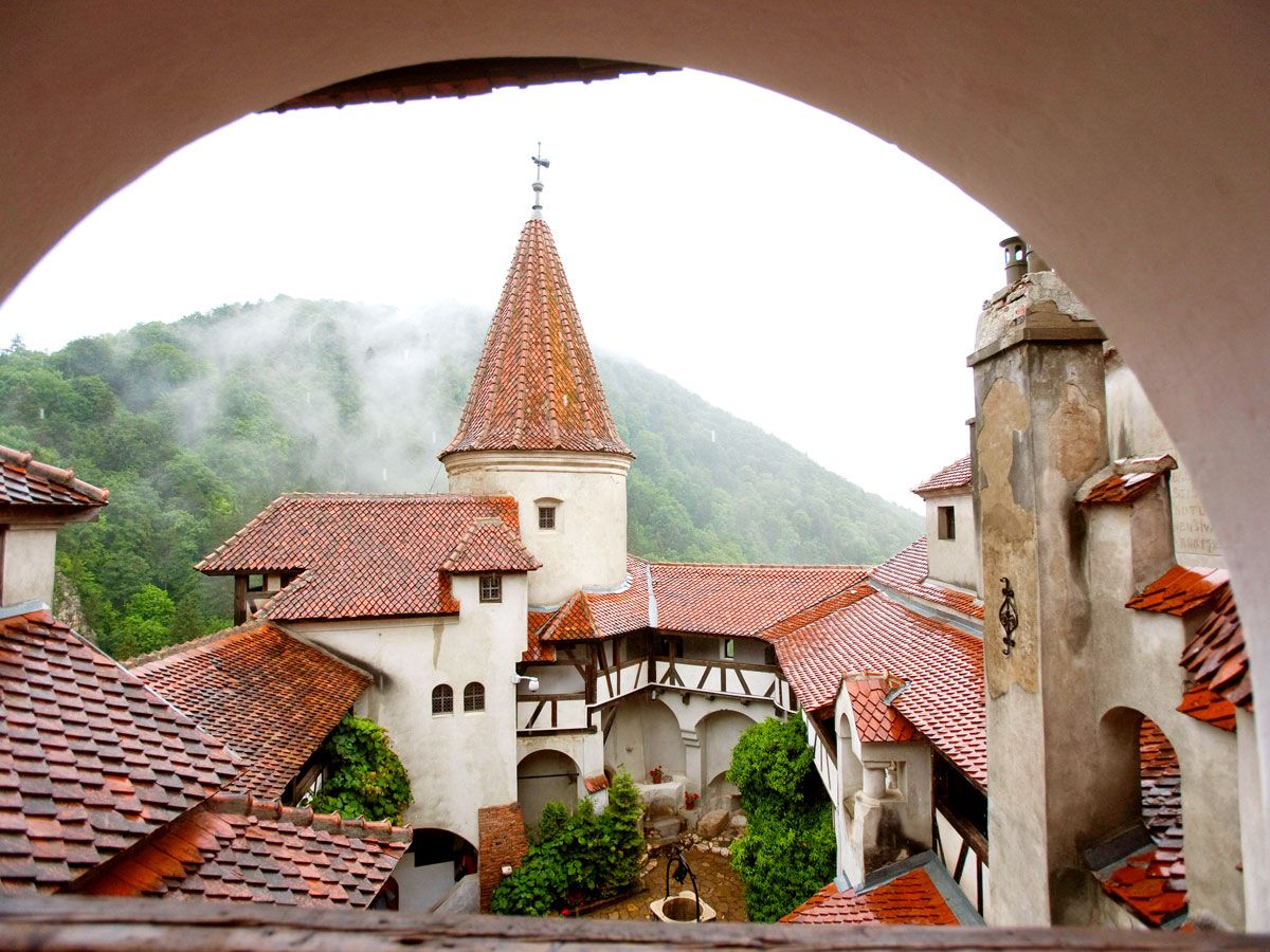
The medieval beauty of Romania’s Bran Castle wouldn’t look out of place in a Disney movie. But the elegant stone structure — situated in the Carpathian Mountains, on the border between Transylvania and Wallachia — appears to be a bit more sinister than Cinderella’s castle. The Irish writer Bram Stoker used the castle as the inspiration for his Gothic horror novel Dracula, despite never having actually visited the location. Even without a vampire, Bran Castle has more than enough ghost stories, as it was the actual home of Vlad Tepes, a 15th-century military leader better known as Vlad the Impaler for his brutal persecution of his enemies. The screams of his victims are said to still echo through the castle, which hosts paranormal investigators — and an over-the-top annual Halloween bash.
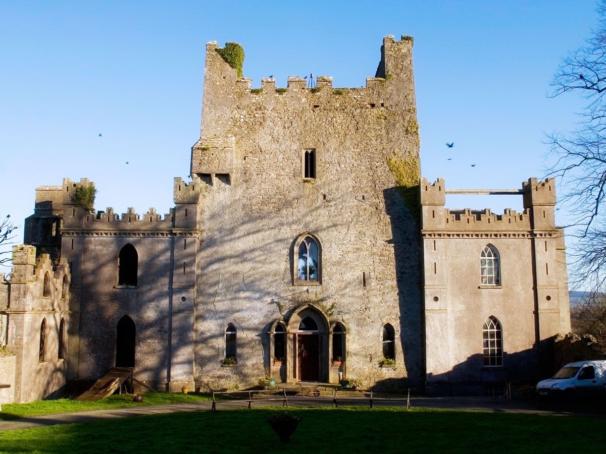
This 15th-century County Offaly fortress bears the title of “Ireland’s Most Haunted Castle,” and for good reason. The brothers of Clan O’Carroll, who ruled over the area when the castle was built, battled bitterly — including at one particularly memorable mass when one brother stabbed and killed another (who happened to be a priest) in what is now referred to as “the Bloody Chapel.” But the piece de resistance of this spooky stronghold is a trapdoor that opens to a spike-filled dungeon. Three cartloads of human bones were found among the spikes when the dungeon was discovered during renovations in 1922, leading to many reported paranormal sightings in the years since.
Japan’s largest castle has a ghostly history worthy of a Hayao Miyazaki fantasy. The feudal complex, located outside of Kobe, was named a UNESCO World Heritage Site in 1993 as “the finest surviving example of early 17th-century Japanese castle architecture.” Nicknamed the “White Egret” for its snowy walls, Himeji Castle is also famous for the vengeful ghost who, according to legend, walks among the castle and grounds. Legend has it that even though the Edo-era hilltop fortress is said to be protected from evil spirits by magic-imbued tiles, it is home to the ghost of Okiku, a young servant who was falsely accused of stealing tableware and executed after rejecting the advances of a samurai.
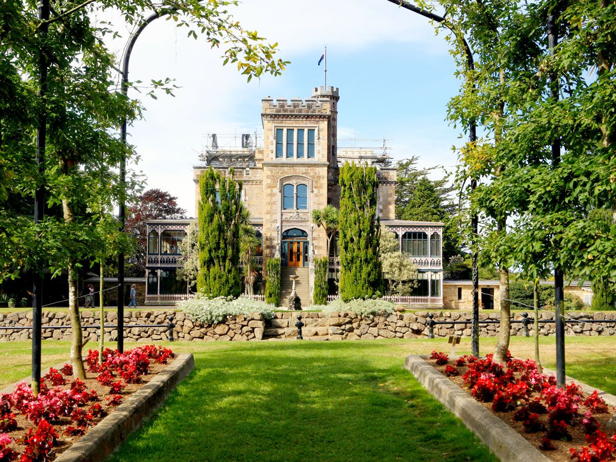
When touring this picturesque Gothic Revival castle on New Zealand’s Otago Peninsula, listen for a whisper in your ear or wait for a cool tap upon your shoulder. It might be the ghost of Kate, the young spirit who’s said to be especially fond of Larnach Castle’s ornate 3,000-square-foot ballroom. Businessman and politician William Larnach built the magnificent estate, New Zealand’s only castle, in 1871 for his wife Elizabeth. The construction and decorations took almost 15 years to complete, and the ballroom’s opening coincided with the 21st birthday of their eldest daughter, Kate. The young woman — who tragically died of typhoid at the age of 26 — is said to be one of several spirits responsible for the ghostly goings-on at this eerie estate.
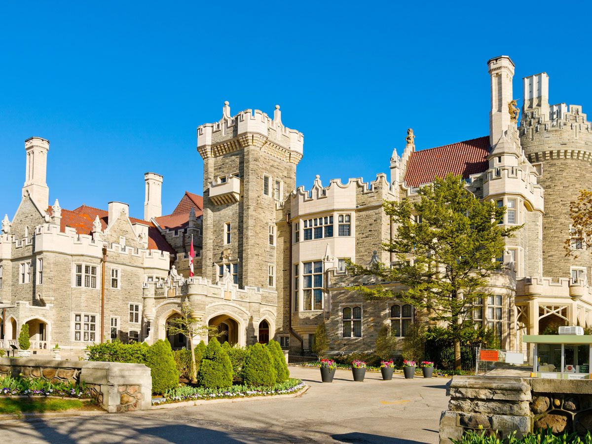
You may already be familiar with the supernatural apparitions at this grand mansion often called “Toronto’s Camelot.” That’s because the imposing Gothic Revival estate in midtown Toronto has appeared in X-Men (as the Xavier School) as well as in many other films, and its castlelike resemblance to Hogwarts has made it the site of many Harry Potter-themed events. Casa Loma was built from 1911 to 1914 by stockbroker Sir Henry Pellatt and later filled with many European treasures. Its original owner and his wife, Lady Mary, reportedly still appear, as does the specter of a maid who died during the Great Flu of 1918. The haunted history of the castle makes it a favorite for Halloween festivities.
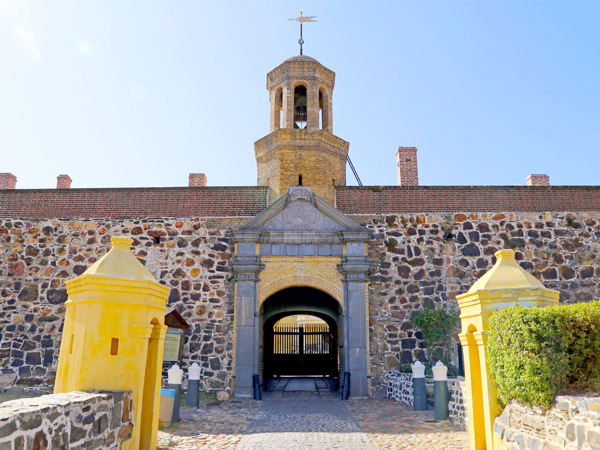
A large black dog that viciously leaps at visitors before vanishing into thin air, a light that turns itself off and on, and a bell that rings with no one at the rope are just a few of the alleged apparitions that can be found at the optimistically named Castle of Good Hope. The oldest building in South Africa, the Cape Town defensive structure was built in 1679. It once held a notorious prison containing a dungeon, which, during winter floods, drowned its prisoners — who are said to now roam the castle as ghosts and haunt its visitors.
Advertisement
More from our network
Daily Passport is part of Inbox Studio, an email-first media company. *Indicates a third-party property.
Daily Passport writers have been seen in publications such as National Geographic, Food & Wine, CBC, Condé Nast Traveler, and Business Insider. They're passionate about uncovering unique destinations and sharing expert tips with curious travelers.
If you’re a fan of vibrant colors, there are many stunning corners of the globe where you can experience all shades of the rainbow. While some destinations feature façades in a dazzling array of colors, other cities stick to a specific hue, with their impressive uniformity making them all the more stunning. You certainly won’t get the blues in these five famous blue towns around the world.
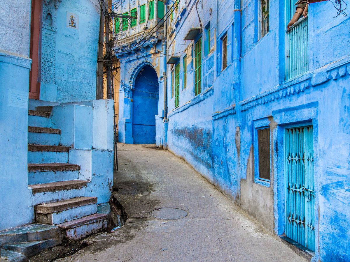
Once the capital of the kingdom of Marwar, Jodhpur is the second-largest city in the Indian state of Rajasthan. It is also known worldwide as the “Blue City of India.” Jodhpur was founded in 1459 and was an important trading hub due to its geographic location on key routes between the East and West. Home to over a million people, the city is distinguished by its rows and rows of azure-colored buildings that now stretch far beyond the original walled city.
The color blue has religious connotations in India. In the Hindu religion, blue is linked to the god Lord Shiva, who drank poison to save Earth. In doing so, his blood turned blue and his followers adopted the shade. Another religious theory is that blue was the color of the Brahmin (priest) caste of India and that the priests would paint their houses to reflect their social status.
There are other non-religious theories to explain the love of blue. Many say it helps to keep the houses cool by reflecting the sun’s rays. Since Jodhpur endures some of the highest temperatures in all of India, any attempts to keep cool would be welcome. Others believe it keeps termites away. On a more practical note, the color might simply be due to the availability of building materials at the time — specifically limestone and copper sulfate, which create a rich blue when combined.
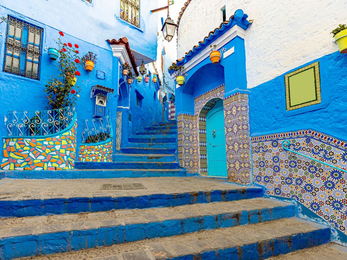
The city of Chefchaouen is located in northwestern Morocco, not far from the major city of Tangiers. It was founded in 1471 as a fort town to protect against Portuguese invaders. Later, it fell into Spanish hands and remained part of Spanish Morocco for several centuries. Today, the city of almost 43,000 is a popular tourist destination among Europeans, who flock to the city each summer to shop and admire the blue architecture. The beautiful azure buildings have helped the city earn the nickname the “Blue Pearl.” For those counting, there are at least 50 distinct shades of blue on Chefchaouen’s walls.
But why blue? There are several theories as to why the color is so prominent in the area. Some claim that the color acts as a natural mosquito repellant. Although the insects like living near water, they dislike going in the water and so the theory is that painting a house blue will keep them from going inside. Other locals say it helps to beat the oppressive summer heat, but some simply suggest that the color serves as an aesthetic reminder of the nearby Mediterranean and adds personality to the village, drawing valuable tourism dollars.
The reality is most likely a combination of all of these reasons, and one more that links them all. In 1492, Sephardic Jews fled the Spanish inquisition and settled in Chefchaouen. With them, they brought their tradition of painting houses blue. The color acts as a reminder of the sky, and of the presence of God. It is likely that for a long time, only the Jewish parts of the city were painted blue, and some residents say that it has only been in the last few decades that the color trend has spread.
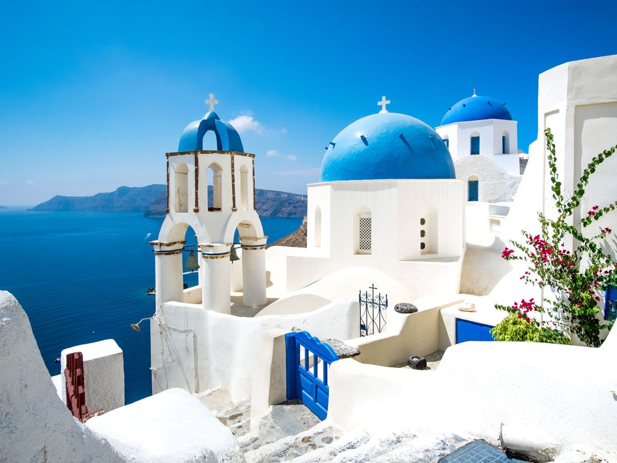
The Greek island of Santorini is a popular tourist destination with beautiful beaches, views of the azure Mediterranean, and laid-back tavernas. The village of Oia is particularly attractive and is one of the most photographed destinations in the region. Its gleaming whitewashed buildings are offset by colorful roofs and blue accents. Blue isn’t the only color on display here, as some roofs are painted shades of pink and red, but the village’s famous three blue-domed churches dominate the landscape.
One obvious explanation for the color choice might be patriotism. After all, blue and white are the colors of the Greek flag. They are also aesthetically pleasing in this Mediterranean locale, and the white does reflect the sun’s rays, keeping the heat at bay. Then there is the more practical explanation of the available building materials used. When mixed with local limestone, a common cleaning agent, loulaki, forms a vibrant cerulean blue paint. Since it is easy and cheap to find, as well as pretty, loulaki is a popular choice.
In the seaside suburb of Sidi Bou Said in the city of Tunis, bright blue adorns doors, window shutters, chairs, and more to provide the perfect accent to the town’s whitewashed homes. With a population of about 6,000, the town sits atop a hill overlooking the coast and provides a peaceful retreat from the hustle and bustle below.
Sidi Bou Said’s origins predate the 13th century, when Sufi prophet Abu Said Ibn Khalef Ibn Yahia El-Beji settled here. After his death, it became a popular pilgrimage site and the town, formerly known as Jebel El-Manar (Fire Mountain), eventually adopted his name.
Over the years, Sidi Bou Said has gained a reputation as a mecca for artists. French painter Rodolphe d’Erlanger was largely responsible for helping to spread the color palette during the 1920s, and his home is now a museum devoted to North African musical instruments. Later, the town attracted such luminaries as painter Paul Klee, philosopher Michel Foucault, and author André Gide.
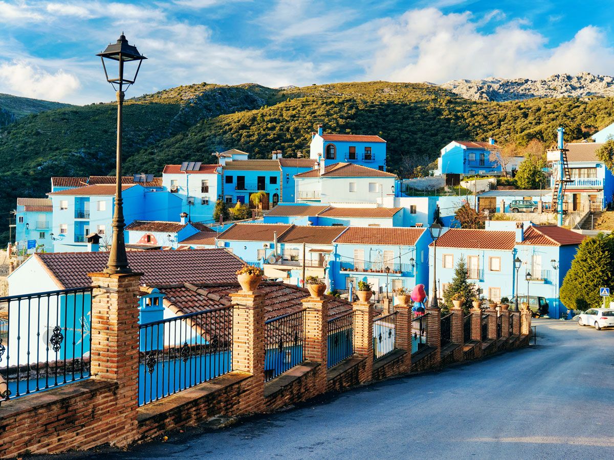
This Spanish village’s love of the color blue doesn’t have to do with the weather, religious symbolism, or architecture. Instead, the Spanish city of Júzcar was inspired by the beloved cartoon characters, the Smurfs. Situated in the hills of Andalusia, Júzcar was, like other villages in the region, traditionally painted white. In 2011, the village of 225 people entered into a deal with Sony. They would paint the town blue to help promote the The Smurfs movie franchise. Why this village in particular? Apparently, Júzcar is known for its mushrooms, the Smurfs’ preferred home.
Originally the deal was that Sony would repaint the town its original white color at the end of the promotional period. However, the townspeople voted to keep the blue. One very likely reason for the preference was that the village has flourished since the color change. Thousands of tourists now flock here annually — a financial boon for the rural area.
A legal dispute over copyright means that, since 2017, Júzcar has referred to itself as the “blue village” rather than the “Smurf village.” As such, the Smurf statues and murals that dotted the village are mostly gone. But there is no ignoring the brilliant color that lives on.
Advertisement
More from our network
Daily Passport is part of Inbox Studio, an email-first media company. *Indicates a third-party property.
Architecture •October 2, 2023•Updated: May 16, 2024
By Daily Passport Team
Author
Daily Passport Team
Daily Passport writers have been seen in publications such as National Geographic, Food & Wine, CBC, Condé Nast Traveler, and Business Insider. They're passionate about uncovering unique destinations and sharing expert tips with curious travelers.
The sprawling, opulent mansions and estates built by many of America’s wealthiest tycoons in the late 19th and early 20th centuries offer a fascinating window into the country’s architectural history. While these lavish properties no longer serve as private residences, many have been repurposed as museums that welcome visitors to step back in time to the grandeur of another era. From America’s largest privately owned home — covering a whopping 175,000 square feet — to a Gatsby-era summer retreat on Long Island, here are 10 of America’s most beautiful and historic mansions you shouldn’t miss.
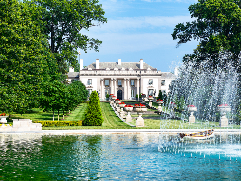
Nemours Estate – Wilmington, Delaware
Credit: John Greim/ LightRocket via Getty Images
In 1909, American industrialist Alfred I. du Pont gifted his wife Alicia this vast estate located less than a mile from downtown Wilmington. He dubbed it the Nemours Estate, named after the French commune where his great-great-grandfather once lived. Esteemed architectural firm Carrère and Hastings — the team behind the New York Public Library and Ponce de Leon Hotel in St. Augustine, Florida — designed the French neoclassical complex and surrounding gardens.
Over a century later, the Nemours Estate is open to the public, welcoming visitors to tour its 47,000 square feet of living space. There are 105 individual rooms, 77 of which are publicly accessible, but the real highlight is the 200 acres of French-style gardens inspired by those at the Palace of Versailles. The expansive gardens feature neoclassical monuments, vibrant wildflowers, and calming fountains throughout, making it a serene escape from downtown Wilmington.
The Nemours Estate also features a garage containing a collection of rare and vintage automobiles, such as antique Rolls-Royces and Cadillacs. The property offers regular tours from April through December, as well as live music during the summer months.
During travels to Asheville with his mother in 1887, bachelor George Washington Vanderbilt II grew fond of the region just south of the downtown area. The area was known for its mild climate, clean air, and pristine setting near the Blue Ridge Mountains. After six years of construction, from 1889 to 1895, Vanderbilt took up residence on the property he commissioned and then married and started a family.
Today, the impressive site — all 175,000 square feet and 8,000 acres of it — is a National Historic Landmark, with a team dedicated to preserving the estate and its history. It remains the largest privately owned home in the United States, a 250-room French Renaissance-style chateau with 35 bedrooms, 43 bathrooms, 65 fireplaces, and even a bowling alley. Guests will encounter a different experience each time they visit, from “Biltmore Blooms” in spring (spotlighting the work and legacy of Frederick Law Olmsted, designer of the estate’s beautifully manicured gardens and grounds) to “Christmas at Biltmore,”when dazzling holiday light displays and festive yuletide decor help to create lasting holiday memories.
Beginning in 1886, another famous Vanderbilt — Lila Vanderbilt Webb and her husband William Seward Webb — consolidated 32 farms into a 3,800-acre, Gilded Age agricultural estate. Designed by architect Robert H. Robertson, the buildings include the Shelburne House (the Webbs’ shingle- and Queen Anne-style residence, complete with Lila’s design for a formal Italianate flower garden), the Farm Barn, the Coach Barn, and the Breeding Barn. Landscape designer Frederick Law Olmsted (of Central Park fame) conceptualized the original 4,000 acres of pastures and woodlands, which still offer show-stopping views of the Adirondack Mountains across Lake Champlain.
Today, the estate functions as a nonprofit organization and a working farm with a mission of cultivating learning for a sustainable future. Guests can visit for a number of experiences, from tours and talks to overnight stays at the 24-room inn. Visitors looking for a taste of the team’s philosophies can try them firsthand at the acclaimed farm-to-table restaurant.
Highlands Ranch Mansion & Historic Park – Highlands Ranch, Colorado
Photo credit: Kathryn Osler/ The Denver Post via Getty Images
Originally built as the residence for business magnate Samuel Allen Long in the late 1800s, this mansion has since become home to some of Denver’s most famous families, from cattle barons to oil tycoons to politicians. In 2012, after decades of private residence, the Highlands Ranch Metro District chose to renovate the property and open it to the public to help honor the region’s rich ranching history.
Visitors can explore 27,000 square feet of grandeur — including 14 bedrooms, 11 bathrooms, five fireplaces, a great room, a ballroom, a dining room, a billiard room, a library, and a private courtyard — along with nearly 50 acres of gardens and trails surrounding the mansion. (That number will grow to close to 250 acres in the future.) View the mansion’s calendar to confirm tour dates and hours, which typically take place on Tuesdays and Thursdays.
Situated steps from Sarasota Bay, this property built in 1926 originally functioned as the winter home of John Ringling (one of the five brothers who founded the Ringling Bros. Circus in 1886) and his wife Mable. Though often referred to as the Ringling Mansion, the home’s official name, Ca’ d’Zan, translates to “House of John” in the Venetian dialect, referencing the couple’s longtime interest in Venice, Italy. They visited with their architect Dwight James Baum several times to gain inspiration for the home.
Baum called upon eclectic design influences rooted in Venetian Gothic and Italian Renaissance styles, along with Spanish and Moorish revival styles. The latter two were especially popular at the time — the Florida land boom years of the 1920s, when Sarasota transformed from a remote fishing village into a luxe resort destination drawing wealthy tourists and residents. Today, guests can embark on self-guided tours across the property’s 36,000 square feet and stunning gardens. Don’t miss the Ringling arboretum, with an impressive collection of more than 2,350 native and exotic trees.
This 1919 French-inspired chateau originally served as the summer home of Otto Hermann Kahn and family — and as a place for the investment banker, art collector, and philanthropist to host lavish Gatsby-esque parties. The second largest private residence in the United States (after the Biltmore Estate), Oheka Castle was built on 443 acres at the highest point on Long Island. (The name “Oheka” is an acronym for Otto HErmann KAhn.)
The estate covers more than 115,000 square feet and features 117 rooms and 50 bathrooms. Guests can enjoy that decadence today both for guided tours and as a wedding and event destination. You may also recognize the lavish location from the music video for Taylor Swift’s 2015 No. 1 song “Blank Space” and shows such as Succession and Madam Secretary.
Newport is renowned for its Gilded Age oceanside mansions, which can be enjoyed along the 3.5-mile-long Cliff Walk. But if you’d like to venture inside one of these impressive estates, consider visiting Rough Point. This waterside estate was built between 1887 and 1892 for Frederick William Vanderbilt, though a then-12-year-old Doris Duke inherited the property in 1925. After Duke became a wealthy philanthropist herself, she renovated the English manorial-style home in the late 1950s to restore its splendor.
Rough Point contains 45 rooms, many with stunning views of the Atlantic Ocean. Upon Duke’s passing in the early 1990s, the mansion was converted into a museum, and much of her furnishings were left untouched. The museum contains an impressive art collection, which includes works from Flemish master painter Anthony Van Dyck, as well as a painting of a young girl by Pierre-Auguste Renoir.
The gardens — which were originally designed by Frederick Law Olmsted, the man behind New York’s Central Park — are also impressive. They contain two camel-shaped topiaries, built in honor of Princess and Baby, Duke’s two beloved pet Bactrian camels who lived at Rough Point during the summer months.
Winchester Mystery House – San Jose, California
Credit: Education Images/ Universal Images Group via Getty Images
Under the watchful eye of owner Sarah Winchester, the Winchester Mystery House underwent a fascinating architectural evolution around the turn of the 20th century. After a series of family tragedies in the 1880s, Winchester — heiress to a sizable firearms fortune — moved from New Haven, Connecticut, to San Jose, where she bought an eight-room farmhouse in 1886. Shortly after, she began a series of renovations that lasted well past her death in 1922.
During that time, the humble home was transformed into a sprawling, labyrinthine estate. Winchester oversaw the project herself rather than hire an architectural firm, though her precise demands and lack of patience led to the repeated commissioning and abandonment of various extensions. This level of unpredictability resulted in the mazelike mansion visitors can explore today.
As a result of the property’s many renovations, the complex eventually grew to cover 24,000 square feet, which includes 160 rooms, 10,000 windows, 2,000 doors, 47 fireplaces, and six kitchens, as well as various curious features such as stairways that lead nowhere. At the time of Winchester’s death, $5 million had been invested into the project, equivalent to more than $90 million today. The home’s eccentric design has drawn more than 12 million visitors since the property opened to the public in 1923. Whether you embark upon a regular guided tour or a spooky flashlight tour to add even more mystery to your experience, this Victorian and Gothic-style mansion is a must-visit.
Located along the shores of Lake Superior, Glensheen sits on a 12-acre property purchased by the Congdon family in 1903. Chester Congdon, who moved from St. Paul to Duluth a decade prior, made a fortune mining the nearby Mesabi Iron Range, which he used to construct this new residence for his family in 1908. The new home was named Glensheen after the Scottish word glen for a narrow valley, and Sheen, the Congdon family’s ancestral English village.
The Jacobean Revival-style structure contains 39 rooms, covering 27,000 square feet of living space. The cost of building this impressive manor was $854,000 at the time, or more than $30 million today. The property features more than 30 species of trees, lakeside terraces, and many walking paths that complement the natural beauty of the adjacent Great Lake. Inside the home, one of the main highlights is the breakfast room, with its unique green-tiled floors and pristine views across Lake Superior. In 1979, the home opened as a museum, offering guided tours as well as a summer concert series along the pier.
You won’t find many historic 19th-century mansions in the Southwest, makingRiordan Mansion in Flagstaff somewhat of a diamond in the rough. The home was designed for Michael and Timothy Riordan, brothers who moved to Flagstaff in the 1880s to work in the timber industry. This property, completed in 1904, is a remarkable example of the American Arts and Crafts style. Two individual homes, one built for each brother, are connected by a rendezvous room in the middle, encompassing 13,000 square feet in total.
There are more than 40 rooms throughout the Riordan Mansion, which is part of a larger state park opened in the late 1970s. Within the home you’ll find many of the original furnishings — volcanic stone arches, hand-split shingles, antique carpets, and period furniture. The complex also contains a garage that’s since been converted into a small museum containing exhibits about the Riordan family and their contributions to the surrounding town. The mansion and the surrounding five-acre parkland can be visited for a modest admission fee, and guided tours are also available.
Advertisement
More from our network
Daily Passport is part of Inbox Studio, an email-first media company. *Indicates a third-party property.
Outdoors •October 2, 2023•Updated: October 2, 2023
By Bradley O'Neill
Looking to embrace and explore the majestic natural beauty of the United States? There are few better places to do so than at its 63 national parks. Surprisingly, however, over 50% of annual park visits are confined to just 10 popular parks. Here are 10 of the most underrated U.S. national parks where you can escape the crowds.
In a state famous for its breathtaking national parks, Capitol Reef National Park can often be overlooked. Located in south-central Utah, this 100-mile-long geologic monocline filled with red rock formations gives visitors a sense of how our planet might have appeared before human existence. Easily accessible via trails and roads, such as the popular Capitol Reef Scenic Drive, the cliffs, canyons, and domes of this national park boast some of the most spectacular scenery in the country. The most notable of the formations is Capitol Dome, named for its resemblance to the United States Capitol building. September’s annual Heritage StarFest is a highlight for stargazers.
Black Canyon of the Gunnison National Park – Colorado
The distinct topography of Black Canyon of the Gunnison National Park and its plummeting sheer black walls dates back 60 million years. Around that time, an uplift brought ancient metamorphic rock to higher elevations. Volcanic eruptions later buried the uplift in volcanic rock, and the Gunnison River eroded the rock into the sheer canyon visible today. Scenic drives along the South Rim and North Rim roads lead to a series of overlooks and unparalleled views of the canyon. Those who prefer to explore on foot can get up close to this rocky marvel via a series of self-guided trails. Don’t miss the Cimarron Canyon Rail Exhibit, which details the history of the narrow gauge railroad that once ran through the park.
Often called the “Redwoods of the East,” Congaree National Park is home to some of the tallest trees on the East Coast. Located in central South Carolina, Congaree boasts the country’s largest unspoiled old-growth bottomland hardwood forest. Visitors can explore the 26,000-acre park via 25 miles of trails, including the popular Boardwalk Loop, which passes ancient cypresses and loblolly pines that reach over 160 feet tall. The park’s location on a floodplain also makes it a great spot for canoe and kayak trips, with tours departing from Columbia. Mid-May to mid-June is an ideal time to visit to experience Congaree’s synchronized firefly phenomenon.
Located about 70 miles west of Key West, Dry Tortugas National Park is one of the most remote national parks in the country. It consists of seven small keys surrounded by crystalline waters, which teem with marine life and set the scene for unforgettable diving and snorkeling adventures. From exploring the Windjammer shipwreck to snorkeling around the family-friendly Little Africa Patch Reef, there’s something for all ages. On land, Garden Key is home to the historic Fort Jefferson, a one-time deepwater anchorage and military prison that remains the largest masonry structure in the Western Hemisphere. With camping on white-sand beaches and excellent stargazing to boot, the park is a true tropical haven.
Although it’s one of Nevada’s lesser-visited parks, Great Basin National Park is a favorite among nature lovers and outdoor adventurers in the know. Occupying 77,000 acres, the park is relatively small in size but huge in diversity — it’s home to everything from ancient bristlecone pines to alpine environments and sagebrush steppe. Nevada’s tallest point, 13,165-foot Wheeler Peak, is one of the park’s highlights, as are the stalactite and stalagmite-rich Lehman Caves. Visitors can enjoy the former along Wheeler Peak Scenic Drive and the latter on ranger-led tours. Great Basin National Park is also a designated International Dark Sky Park, primed for sightings of meteor showers, the Milky Way, and other celestial wonders.
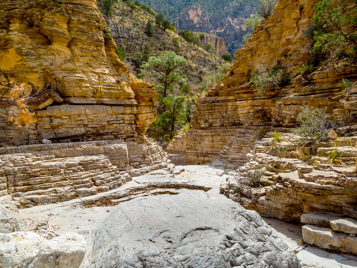
Guadalupe Mountains National Park covers around 86,000 acres of the Chihuahuan Desert in a remote stretch of West Texas. The park comprises mountains, canyons, desert, and dunes — and also shelters the largest Permian fossil reef on the planet. Four of Texas’ tallest mountains are located here, including 8,751-foot Guadalupe Peak. A challenging 4.2-mile hike leads to the top for spectacular panoramas and a bird’s-eye view of the park’s famous limestone rock formation, El Capitan. Despite the desert setting, in fall, the park dazzles in bright shades of red, orange, and yellow. Head to the McKittrick Canyon area for some of the best foliage.
If you’re looking to see geysers, springs, and volcanic peaks in California, Yosemite National Park likely comes to mind. But roughly 300 miles to the north, Lassen Volcanic National Park offers much of the same scenery and with far fewer visitors. The park’s crowning glory is the 10,460-foot Lassen Peak, the world’s tallest plug-dome volcano. Intrepid visitors can trek to the summit for panoramas of the encompassing 106,000-acre wilderness. Other highlights include the bubbling mud pots of Bumpass Hell and the geyser-rich Boiler Springs Lake. You might even spot black bears and coyotes while walking the 150-mile trail network, which connects to parts of the famous Pacific Coast Trail.
Located close to the Canadian border, North Cascades National Park ranks among the snowiest places in the U.S. In this 505,000-acre wilderness, some 300 glaciers tower above densely forested and verdant valleys. Sometimes called the “American Alps,” the park lures backpackers, hikers, and mountaineers with its 400 miles of trails through conifer and maple forests, striking blue lakes, and thundering waterfalls (including the 88-foot-tall Nooksack Falls). Wildlife lovers can spot bears, wolves, and more than 200 bird species. And if you’re a bookworm, be sure to visit Desolation Peak, where beatnik author Jack Kerouac worked as a fire spotter for 63 days in 1956.
You can walk in the footsteps of dinosaurs in the eerie landscape of Petrified Forest National Park in east-central Arizona. A volcanic eruption approximately 225 million years ago turned a region once made up of volcanoes, emerald forests, and rivers into a badland of animal fossils, petrified trees, and solid quartz. Visitors can cruise through this otherworldly landscape on the 28-mile park road, stopping to admire the Painted Desert and see the petroglyphs at Puerco Pueblo. This is the only park in the National Park System that lays claim to a section of the Historic Route 66.
True to its name, White Sands National Park is blessed with enormous deposits of brilliant white gypsum sand that sprawls across 275 square miles of desert. The world’s largest gypsum field, it features undulating, wave-like dunes that could easily be mistaken for snowdrifts. Given its barren terrain and often inhospitable temperatures, one might imagine the park to be devoid of wildlife. However, some 800 species thrive here, many of which are nocturnal. For visitors, the park offers superb biking, hiking, and backcountry camping. At the top of the list for many is the chance to grab a snow-saucer and sled down the dunes that frame Dunes Drive.
Advertisement
More from our network
Daily Passport is part of Inbox Studio, an email-first media company. *Indicates a third-party property.
17 Fascinating Landmarks That Reveal America’s Indigenous History
By
Daily Passport Team
Read time: 11 minutes
September 29, 2023
Updated: September 29, 2023
17 Fascinating Landmarks That Reveal America’s Indigenous History
History •September 29, 2023•Updated: September 29, 2023
By Daily Passport Team
Author
Daily Passport Team
Daily Passport writers have been seen in publications such as National Geographic, Food & Wine, CBC, Condé Nast Traveler, and Business Insider. They're passionate about uncovering unique destinations and sharing expert tips with curious travelers.
Long before Europeans arrived, Paleo-Indians first settled North America around the end of the Ice Age, some 14,000 years ago. Since then, many Indigenous groups have made these lands home. Though the Indigenous history of the United States can often be overlooked, there are plenty of fascinating monuments to learn more about the history of our nation, many of which have stood for thousands of years. Here are 17 landmarks that delve into America’s Indigenous history.
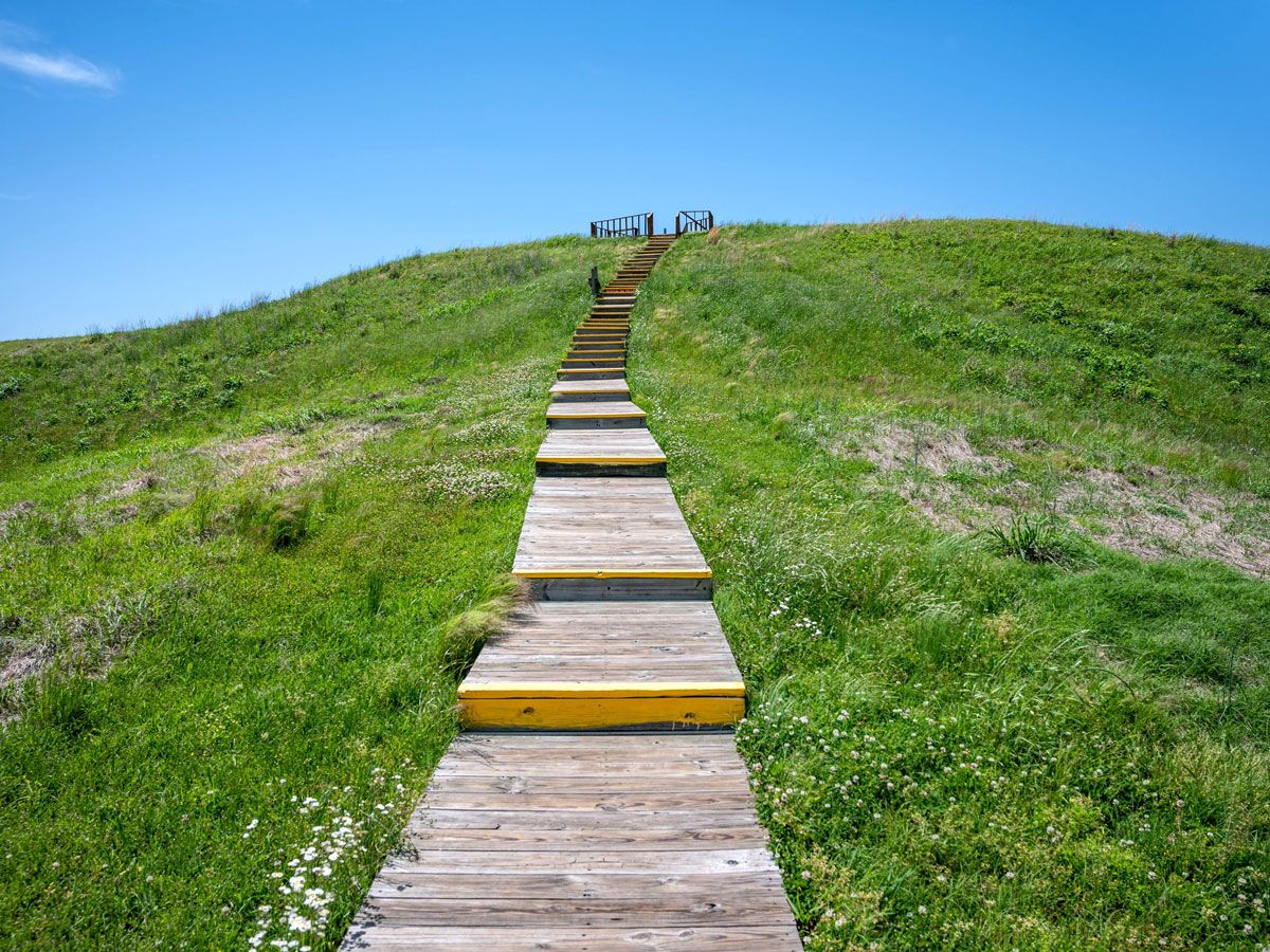
Nearly 2 million cubic yards of soil in northeastern Louisiana have been shaped into a natural wonder at Poverty Point. At the center of this national monument and UNESCO World Heritage Site is a 72-foot-tall mound with concentric circles around it that was constructed by hand more than 2,200 years ago. With no official records, little is known about the Indigenous peoples’ lives there, but it’s believed that some of the materials used to construct the site were brought in from as far as 800 miles away, making it as much of a human-made wonder as Stonehenge. It’s believed that the area was inhabited for about 600 years until it was mysteriously abandoned around 1100 BCE.
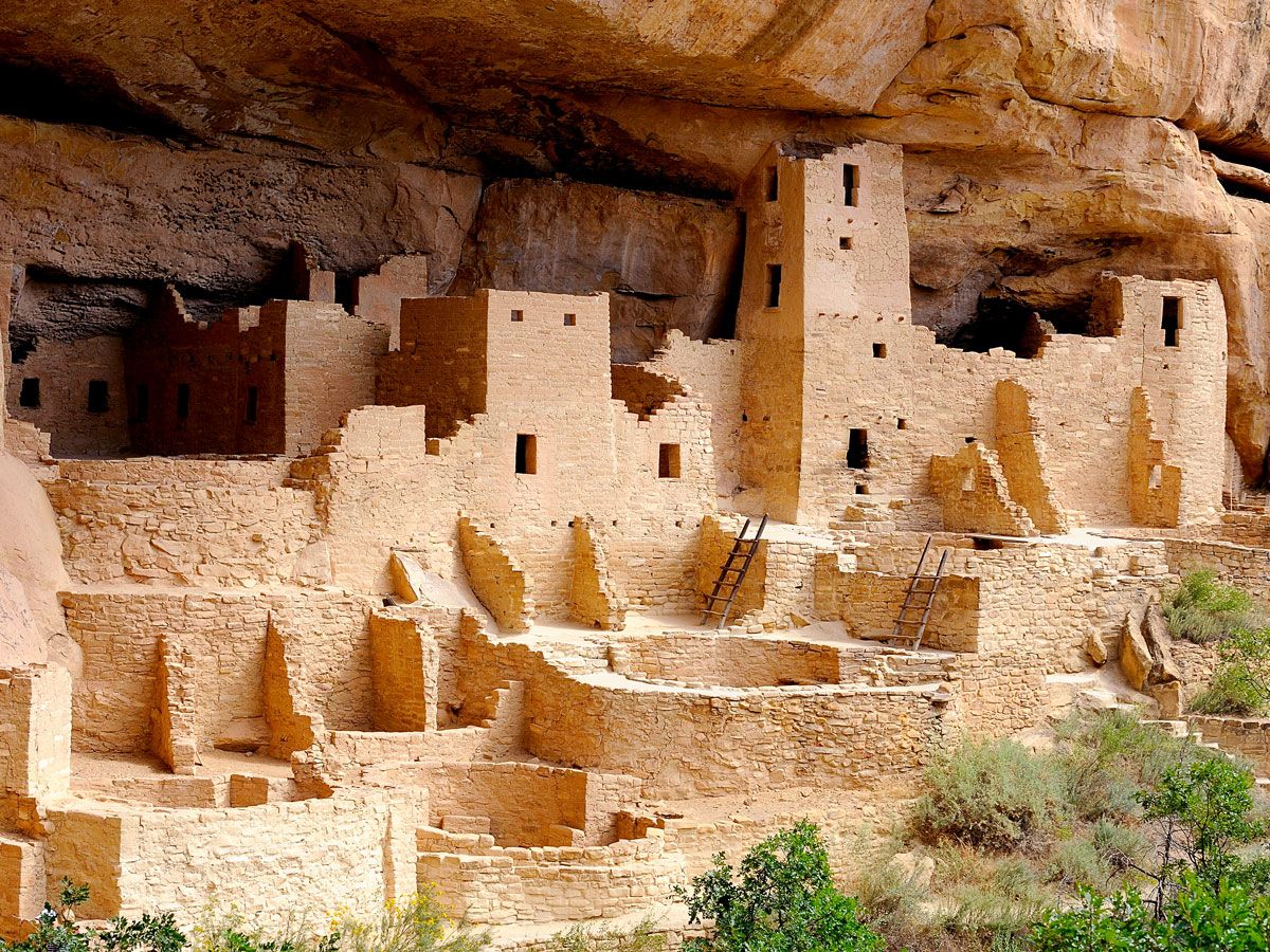
For more than 700 years, the area of Colorado that’s now Mesa Verde National Park was home to the Ancestral Puebloans. Though they had previously been nomadic, they settled in the area around 550 CE, living in pit houses built on top of mesas and into cliff recesses. Through the generations, those evolved into structures built of adobe and poles — some with as many as 50 rooms — and eventually to kivas, pueblos made of stone. But around 1200, they shifted back to living in the cliffside, into the dwellings that Mesa Verde is most known for today.
A generation or two after those canyon alcove homes were built, the population — believed to have reached several thousand — abandoned the entire area. Now the national park, which was established in 1906 by President Theodore Roosevelt to “preserve the works of man,” also protects the heritage of 26 associated tribes, including the Taos of New Mexico, Hopi of Arizona, and Ute Mountain of Colorado.
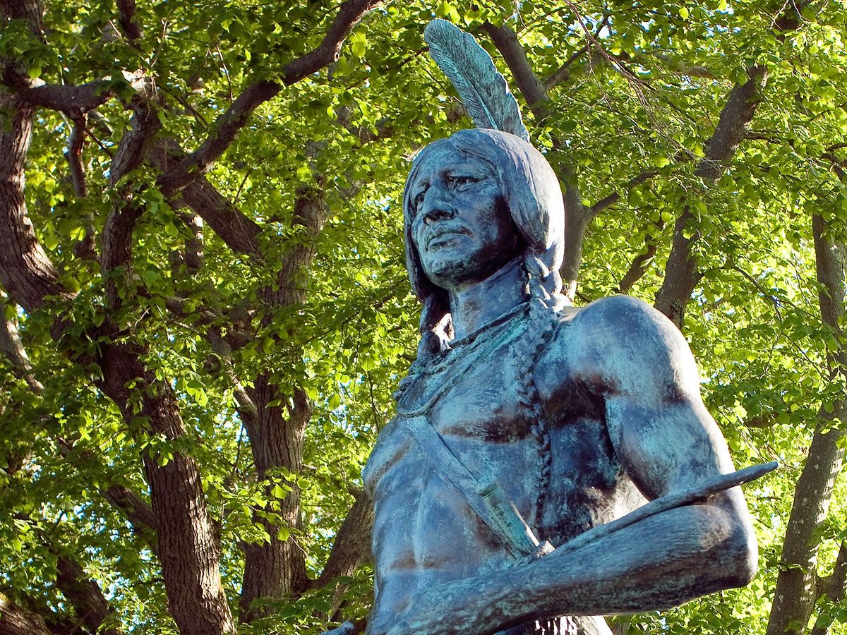
Across the street and above the hill from the famous Plymouth Rock is a statue of Chief Massasoit, who lived from about 1581 to 1661 and was the leader of the Wampanoags, the Native Americans who inhabited New England long before the English arrived in 1620. He is believed to have greeted the Pilgrims, and the following year, he and 90 of his men joined them for three days of feasting, which has evolved into the Thanksgiving tradition.
The sculpture of Chief Massasoit was created by Utah artist Cyrus Dallin in 1921, and the original plaster figure given to the state in 1922. Five years later, a duplicate was funded in bronze and placed in front of the Utah State Capitol in 1959.
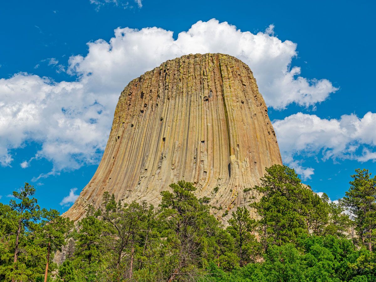
Devils Tower, a striking natural 867-foot-tall formation rising from the prairie of the Black Hills with a flat top the size of a football field, has long been a natural wonder. Scientists believe it formed from molten rock underground which was then pushed upward by magma. The site has long been a sacred one for the Indigenous peoples of the area, and prayer offerings are still made today, marked by colorful bundles placed around the tower.
Associated tribes have given various names to the tower — Araphoes called it “Bear’s Tipi,” Kiowas named it “Tree Rock,” and Lakota — who have the most documented connections with it — gave it various names, including “Bear Lodge,” “Ghost Mountain,” and “Grey Horn Butte.” The Devils Tower name came from an 1875 scientific exploration trip, when an army commander wrote that the Native Americans called it “Bad God’s Tower,” which he translated to “Devils Tower.” However, many early maps of the area call it Bear Lodge, which is translated from one of the Lakota names, Mato Tipila. Efforts have been underway to change its name to Bear Lodge. (You may also recognize the landmark from the 1977 sci-fi film “Close Encounters of the Third Kind.”)
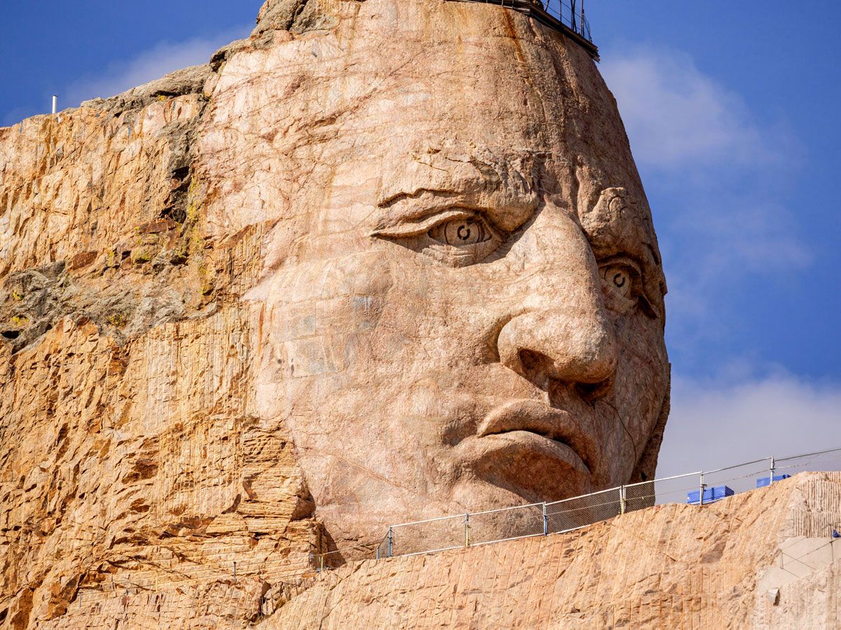
Also located in the Black Hills is a 6,532-foot-tall mountain that is the site of the Crazy Horse Memorial, depicting Oglala Lakota Chief Crazy Horse. It will become the world’s largest sculpture when it’s completed — but when it will be finished is the big question. The project began when Oglala Lakota Chief Henry Standing Bear invited Polish American sculptor Korczak Ziolkowski to the area in 1947 to carve a memorial for all North American Indians. The sculptor started the project in 1948, estimating it would take three decades to complete, but he passed away in 1982.
It’s still a major work in progress — the next five to ten years are scheduled to focus on Crazy Horse’s hairline, right shoulder, and left arm and hand, as well as the horse’s mane and head. Visitors can see the work in progress, as well as two museums, the Indian Museum of North America, and the Native American Educational and Cultural Center.
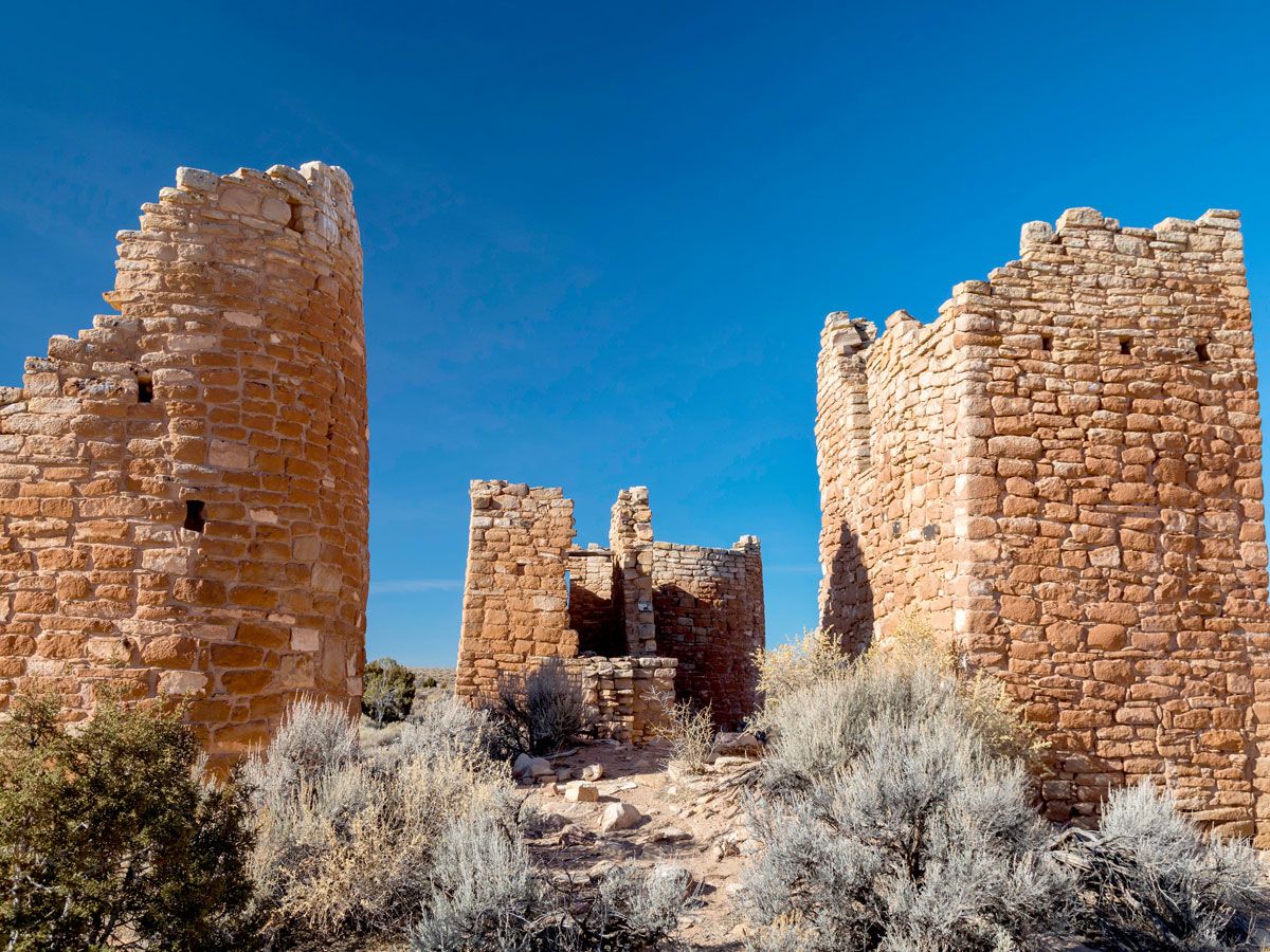
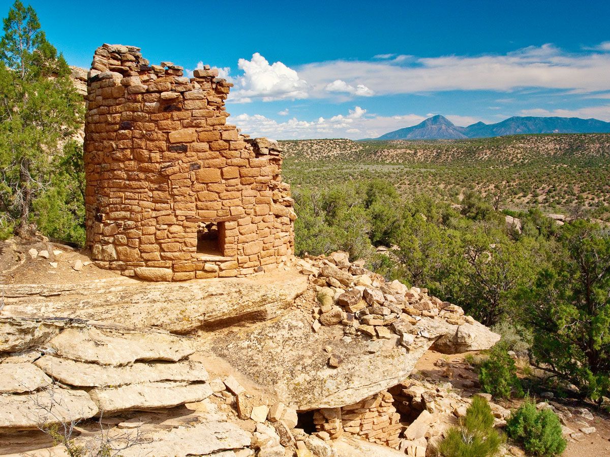
Connected with the nearby Mesa Verde community, the Hovenweep area traces its first human inhabitants back more than 10,000 years ago, when nomadic Paleo Indians would pass through to hunt and gather seasonally. In about 900 CE, the area started to become a more permanent home, and 300 years later, the population reached about 2,500. The remnants of six villages that were built between 1200 and 1300 are now preserved there.
Among the most impressive are the differently shaped towers constructed by the ancestral Puebloans. By the end of the 13th century, the area was abandoned, but Hovenweep (which means “deserted valley” in Ute or Paiute) has been protected as a national monument since 1923 — preserving the cultures of the Pueblo, Zuni, and Hopi peoples.
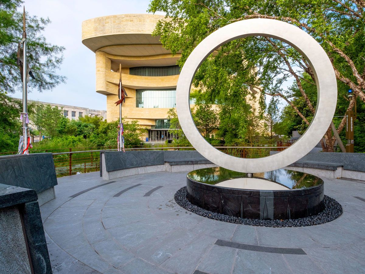
National Native American Veterans Memorial – Washington, D.C.
Opened on Veterans Day 2020, the National Native American Veterans Memorial sits on the grounds of the capital’s National Museum of the American Indian. Selected from more than 120 entries, the Warriors’ Circle of Honor design is the work of self-taught artist Harvey Pratt of the Cheyenne and Arapaho Tribes of Oklahoma, who is a Vietnam War veteran himself.
The memorial’s stainless steel circle sits on a stone drum, symbolizing a sacred circle and the cycles of time and life. Water flows out from the drum, while fire can be lit for ceremonies. The inclusive memorial honors American Indian, Alaska native, and Native Hawaiian veterans — and will be formally dedicated in an on-site ceremony on Veterans Day 2022.
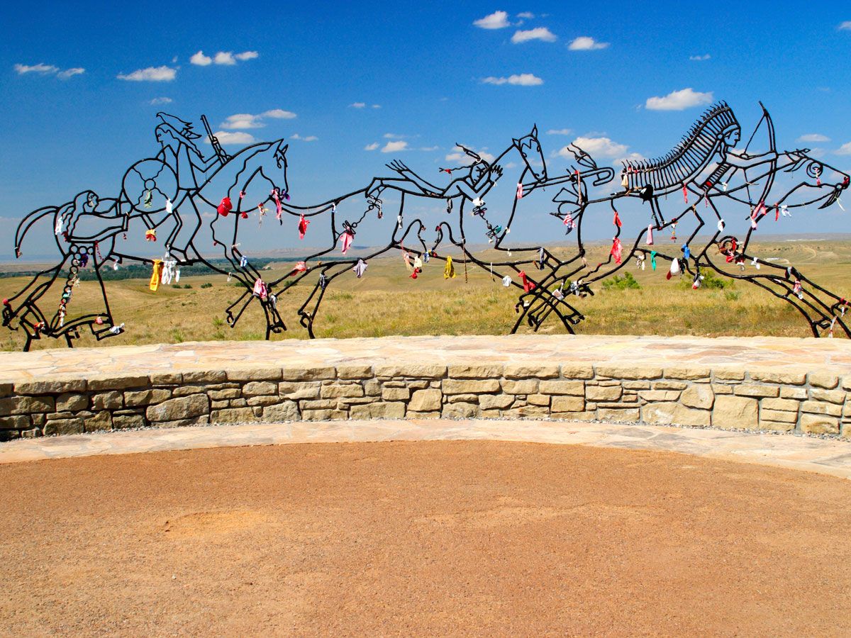
Indian Memorial at Little Bighorn Battlefield National Monument – Montana
The decades-long clash between Native Americans and settlers of European descent came to a climax on June 25 and 26, 1876. At the Battle of Little Bighorn, the Lakota, Cheyenne, and Arapahos defeated the 12 companies of the U.S. Army’s Seventh Cavalry. Though the battlefield became a national cemetery in 1879 and a memorial was built on Last Stand Hill in 1881, most of the bodies of the Native Americans were removed and buried following their traditions — and no memorial existed in their honor.
In 1991, Congress changed the name of the site from its previous name, Custer Battlefield National Monument, to Little Bighorn Battlefield to acknowledge the Native Americans who died there, and also ordered the construction of the Indian memorial, which was dedicated in 2003 with the theme “Peace Through Unity.”
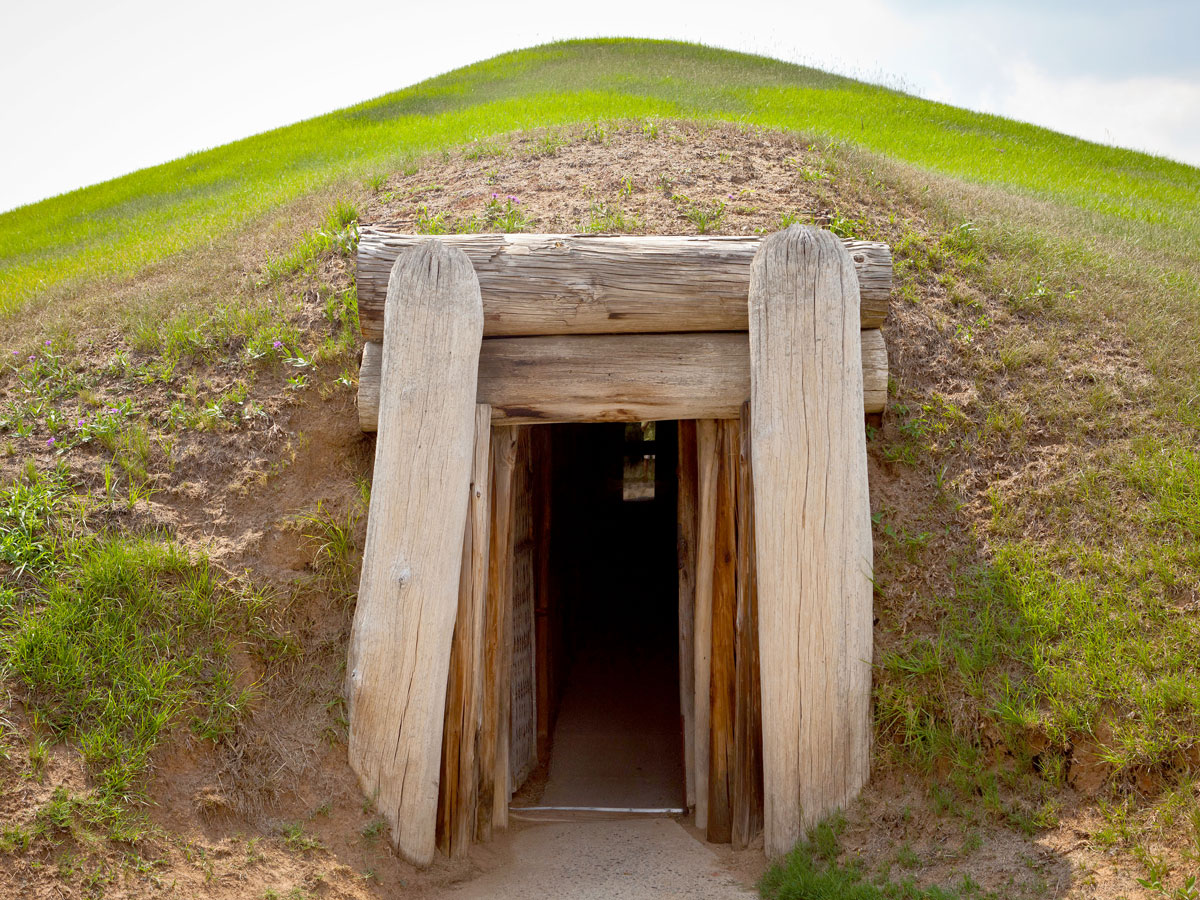
Human settlement in central Georgia dates back nearly 17,000 years ago to the Ice Age, when nomadic Paleo Indians settled in the area. Around 1000 BCE, small villages formed, but it wasn’t until 900 CE that a society emerged known as the Mississippans, who built the site’s trademark Ocmulgee Mounds out of dirt and clay.
Among the circular earthen structures are temple mounds, a cornfield mound, and a funeral mound. The importance of the Indigenous site is evidenced by the fact that the area is on track to becoming Georgia’s first national park, possibly as soon as next year. Visitors can duck inside a re-created earthlodge for a taste of what life was like in the mound, which still has sections of the original 1015 CE floor.
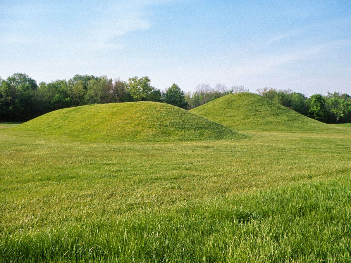
Earthen mounds are also found in Ohio’s Hopewell Culture National Historical Park. These were built from 200 BCE to 500 CE, and are believed to have been used for everything from funerals to feasts, with the Hopewell peoples arranging them in circles, squares, and octagons. The 1,800-acre park has six complexes, including High Bank Works, Hopeton Earthworks, Hopewell Mound Group, Mound City Group, Seip Earthworks, and Spruce Hill Earthworks. Some of the mounds stretch as wide as 1,000 feet.
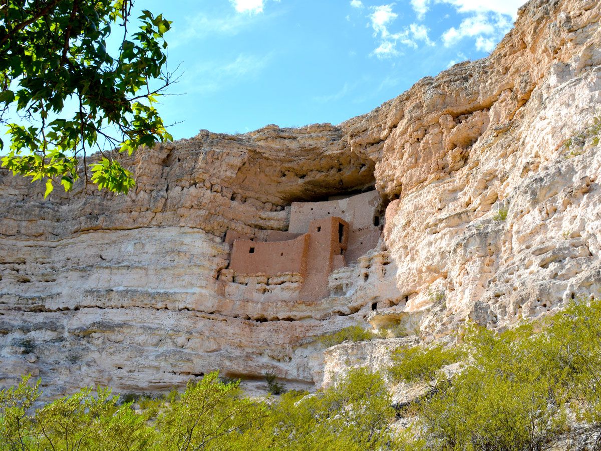
The five-floor, 20-room apartment complex built into the side of the limestone cliff in Arizona’s Cape Verde has long intrigued visitors as one of the most well-preserved prehistoric cliffs in the country. Estimated to have been built between 1100 and 1350 CE, the site is named Montezuma Castle, which comes from the Aztec emperor — even though it seems historically unlikely that he ever came to the area.
Now it’s more widely believed to have been the home of the pre-Columbian Sinagua peoples, who left the region in the 15th century. As one of the nation’s first national monuments dedicated in 1906, President Roosevelt said it was a place of great “ethnological value and scientific interest.”
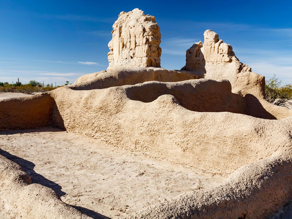
It takes quite a monument to become the nation’s first archeological preserve, and Casa Grande Ruins National Monument had all the right qualifications when it was dedicated in 1892. As the largest known structure built by the Gila Valley’s Hohokam tribe (who lived in the region since 5550 BCE), Casa Grande — which translates to “Great House” — was built in the 14th century using 3,000 tons of caliche soil. The durable structure has four-foot-thick walls at the bottom and Juniper pine and fir tree timbers as support. Also preserved in the area are remnants of the tribe’s farming community, dating from 1150 to 1350.
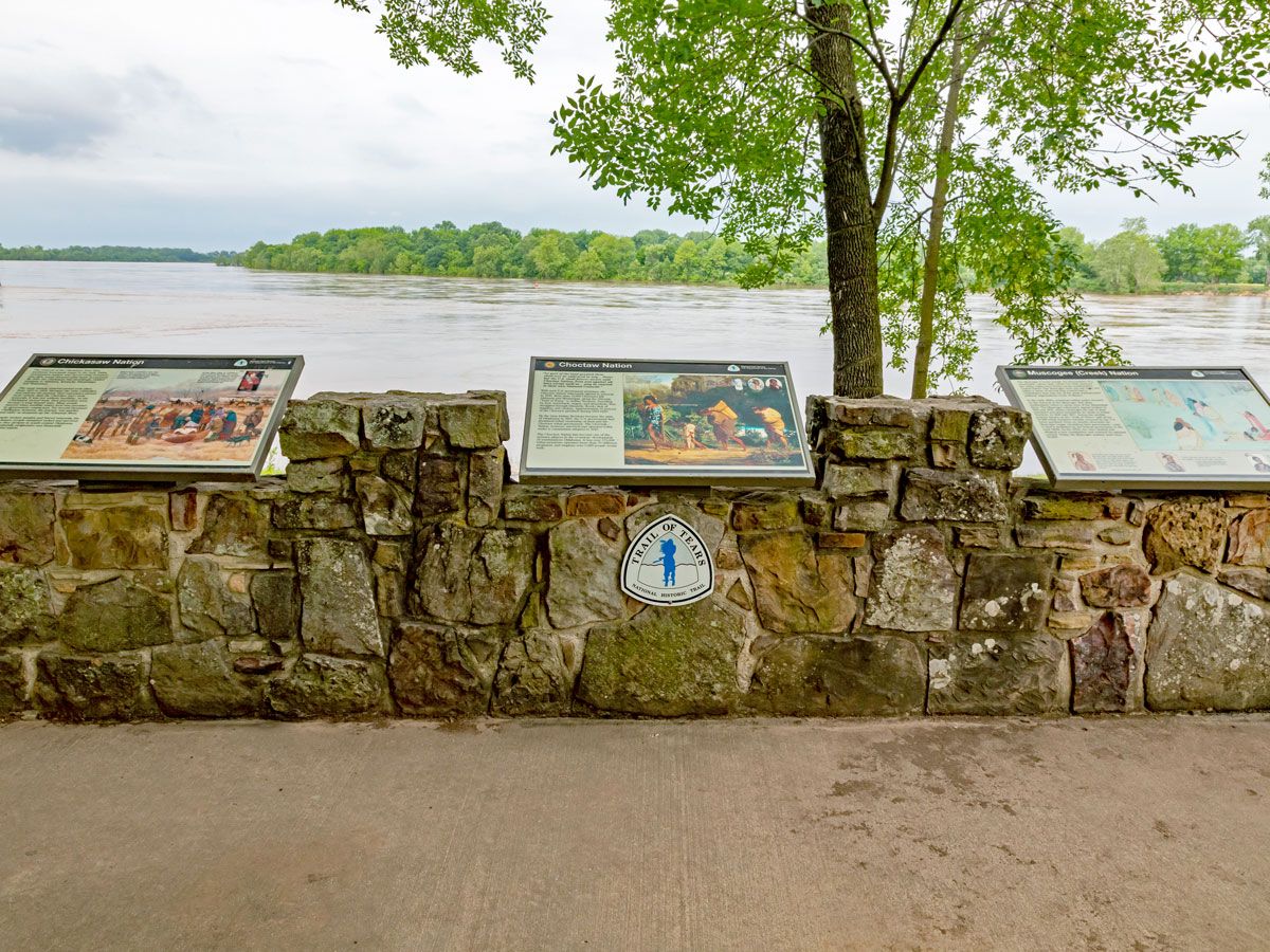
Trail of Tears National Historic Trail – Georgia to Oklahoma
The Indian Removal Act in 1830 forced major tribes — including the Choctaws, Muscogee Creeks, Seminoles, and Chickasaw — to leave their homelands and move west of the Mississpippi to what is now Oklahoma. After initially resisting, the Native Americans eventually were forced to give in and escorted to their new homes by the U.S. Army troops in what was called the Trail of Tears. In total, 16,000 Cherokees alone were taken from Tennessee, Alabama, North Carolina, and Georgia.
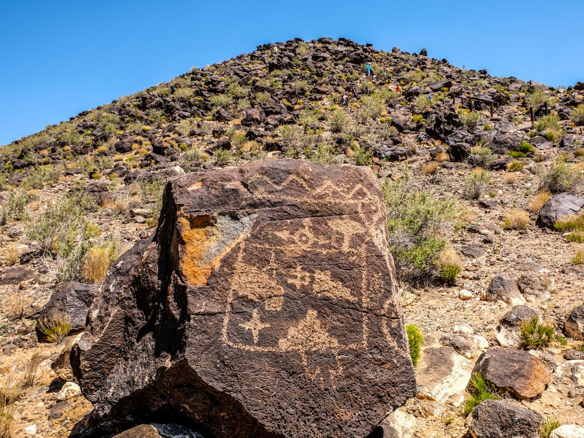
All over this Albuquerque area are symbols and designs carved into volcanic rock, making it one of the biggest petroglyph (or rock carving) sites on the continent. Thought to have been created between 400 to 700 CE, Petroglyph National Monument features three short trails with hundreds of carvings along the way.
These include the Boca Negra Canyon with 100 carvings, the 2.2-mile loop of Rinconada Canyon with 300 of them, and the 1.5-mile Piedras Marcadas trail with a whopping 400 petroglyphs. The symbols are believed to have spiritual meaning — about 90% of them are the work of the ancestors of the Pueblos, who have lived in the Rio Grande Valley since 500 CE.
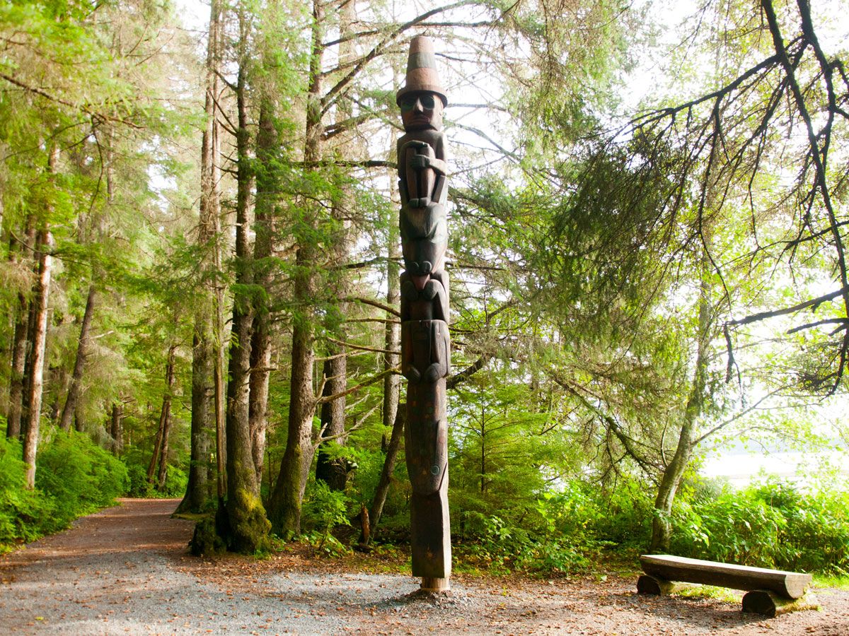
Located in southeastern Alaska on a forested island near the mouth of the Indian River, the Sitka National Historic Park commemorates the histories of two very distinct cultures: the Tingit people and Russian American traders. Both lived and thrived in the area, but tensions came to a head in 1804 at the Battle of Sitka, with the Russians prevailing. The battle site is now memorialized with a trail lined with totem poles of the Tlingit and Haida people along the way.
Canyons of the Ancients National Monument – Colorado
In the southwestern corner of Colorado, along the Dolores River, is the nation’s highest concentration of archaeological sites. Canyons of the Ancients National Monument covers a whopping 176,000 acres; among them are 8,300 sites that feature kivas, villages, field houses, cliff homes, stone carvings, and sweat lodges — showcasing elements of what life was like for the Ancestral Puebloans (also called Anasazi), Ute, and Navajo cultures. The earliest inhabitants of the area go back 10,000 years. The monument also features a research collection with more than 3 million artifacts, as well as two archaeological sites that date to the 12th century.
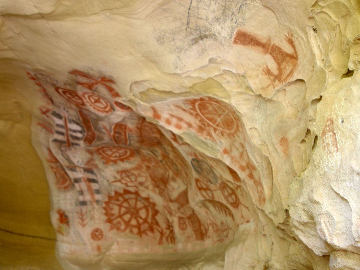
Chumash Painted Cave State Historic Park – California
While the meaning of these cave paintings has been lost over the years, the art in the Chumash Painted Cave are among some of the best preserved works of the Chumash people — who lived along the California coast, both on the mainland and on three of the Channel Islands. The small cave’s imagery, believed to be from the 1600s (or even earlier), is accessible by ascending the steep pathway to the mouth of the cave, where the images are protected by an iron gate.
Advertisement
More from our network
Daily Passport is part of Inbox Studio, an email-first media company. *Indicates a third-party property.
The French Village With a History of Living in Upside-Down Boats
By
Julia Hammond
Read time: 5 minutes
September 29, 2023
Updated: September 29, 2023
The French Village With a History of Living in Upside-Down Boats
Culture •September 29, 2023•Updated: September 29, 2023
By Julia Hammond
Author
Julia Hammond
Julia is a U.K.-based travel writer whose work has been featured in The Independent, The Telegraph, The New Zealand Herald, and Culture Trip, among others. She’s an enthusiastic advocate for independent travel and a passionate geographer who has had the privilege of traveling to more than 130 countries in search of a story.
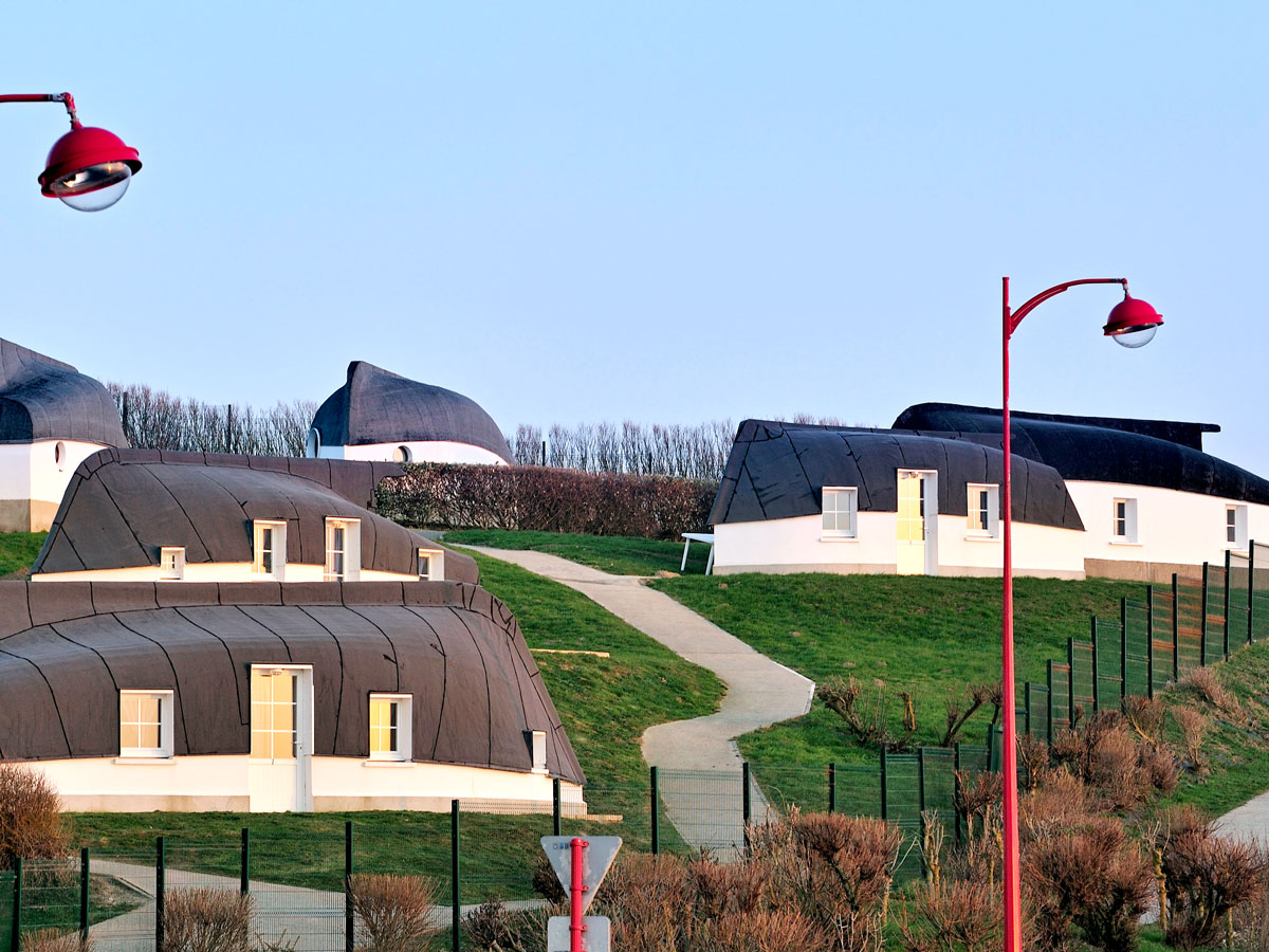
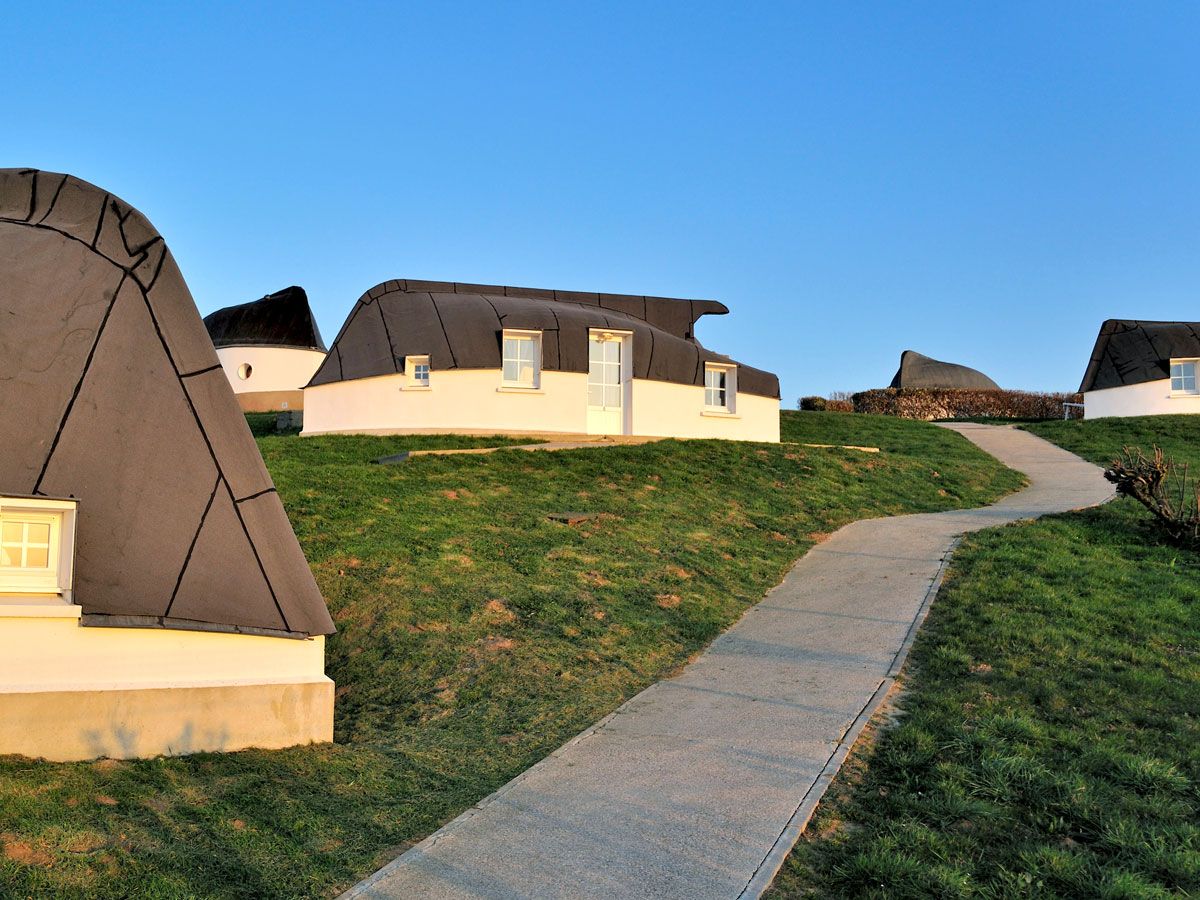
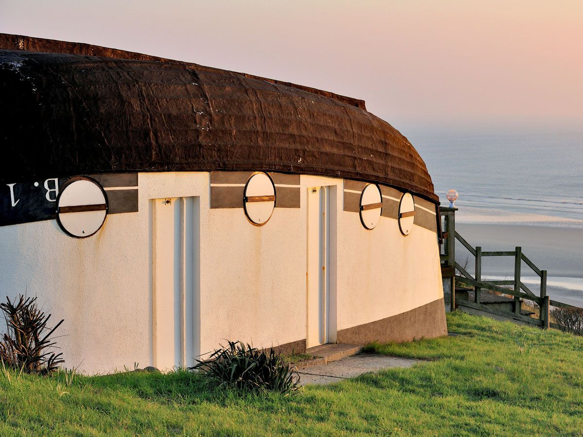
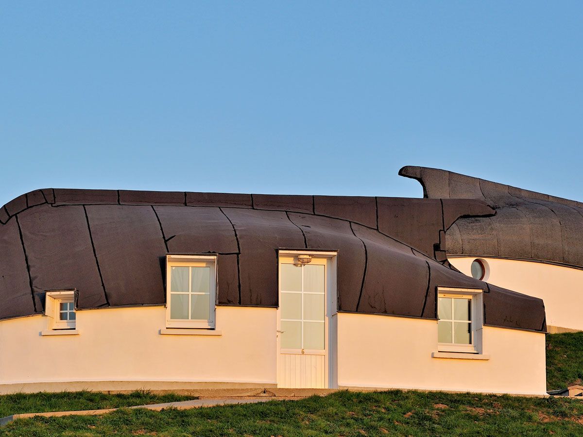
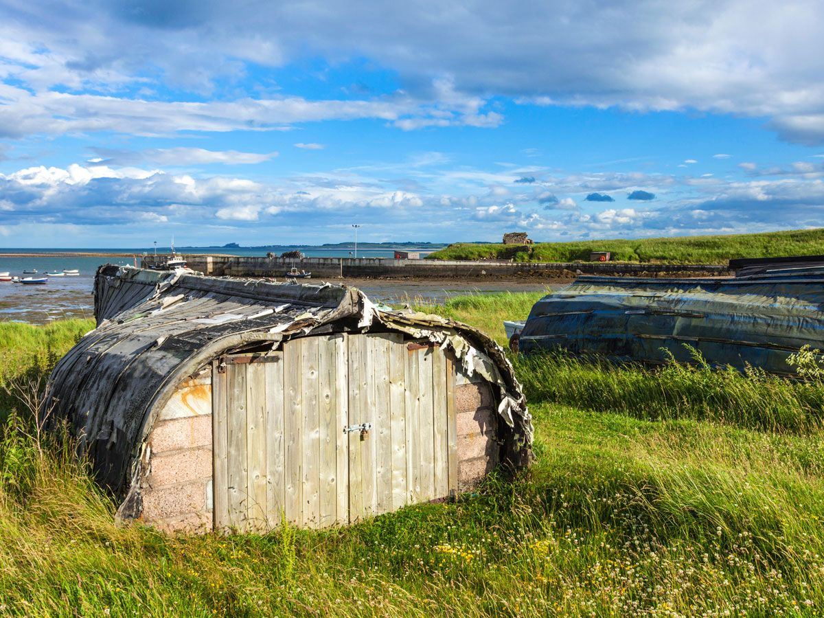
The seaside commune of Équihen-Plage lies on a section of France’s northern coast called Côte d’Opale (Opal Coast), near the port city of Boulogne-sur-Mer. While the relaxed town draws in holidaymakers with its serene beaches, Équihen-Plage has a far more unusual claim to fame: its houses made out of upside-down boat hulls, known locally as quilles en l’air (which translates to “keels in the air” in English). If you’re wondering how these decommissioned fishing boats became unconventional abodes — and later unique accommodations for travelers — dive into the unique history of Équihen-Plage’s upside-down boats.
In the 19th and early 20th centuries, Équihen-Plage was a thriving fishing community. However, the sea here has a significant tidal range, and Équihen-Plage is an example of a port d’échouage, a port that has no water at low tide. Rather than drop anchor offshore, traditionally village fishermen would beach their boats and haul them up the sand by hand (though these days, you might see a tractor being used instead).
Their vessels, called flobarts, are traditional to northern France and have a number of characteristics that make them especially suited to places like Équihen-Plage. They were designed to be capable of floating in just a foot or so of water. Their wide bow was well equipped to deal with strong waves, while the flat stern could be slid into the water on logs whenever it needed to be launched.
More than a century ago, money was tight for many in Équihen-Plage, and nothing was wasted. Boats that were no longer seaworthy were salvaged so they could be repurposed as homes, providing shelter for entire families at minimal cost. First, a low wall was constructed so that the finished dwelling would have sufficient headroom. A doorway-sized opening was then cut from the side of the boat, along with a small window or two. Builders then flipped the vessel over and lifted it on top of the wall. Many were tucked against the hillside, providing some protection against the elements on this wild and often windy coast. But in their original state, the boats would have been drafty and leaky.
The interiors of the quilles en l’air were also fairly basic, lacking adequate ventilation, natural light, and running water. Often simply and sparsely furnished, the boats had an open floor plan to maximize the space. Still, they rarely reached 26 feet long, often resulting in a tight squeeze, given the average family size of the time. But for many of these impoverished families, having an affordable roof over their heads would have been a blessing.
By the time World War II broke out, the days of the quilles en l’air were sadly numbered. In Équihen-Plage, the Quartier des Quilles en l’Air — the district that contained around 20 upturned boats — was a casualty of the bombing raids that flattened many of the buildings in this part of France. The last boat to be occupied was used as a studio by a painter named Paul Christol. It was the only boat to survive this era, albeit with significant damage.
Though the quilles en l’air were gone, they weren’t forgotten. By the 1990s, a desire to resurrect this old tradition arose. Local authorities decided to build new boat houses and rent them out to visitors vacationing in Équihen-Plage. Several decades later, they’re as popular as ever — and often fully booked well in advance.
How to Visit the Upside-Down Boats of Équihen-Plage
Today, the quilles en l’air are located within Camping La Falaise at the south end of Équihen-Plage. If you’re driving, follow Rue Charles Cazin to the main beach parking lot and walk back up to the campsite.
Aside from admiring the boats and their role in the region’s unique cultural history, visitors can also book them for a unique overnight stay. The replica boats are finished to a higher standard than the originals would have been and provide a comfortable, yet simple place to spend the night. In high season (July and August), rentals are only offered on a weekly basis, from Saturday to Saturday. Outside of peak season, visitors can reserve for shorter periods. Prices vary according to both season and size: Two of the eight boathouses sleep only two people, while the others can accommodate parties of up to five people. One is also accessible for people with limited mobility. And all of them have sea views..
If you’re planning to visit in early fall, it’s worth checking out Boulogne-sur-Mer’s Fête de la Beurière. This festival, which takes place during the second weekend in September, celebrates the fishing quarter’s history and traditions. There are typically local historians who will happily share old photos of the quilles en l’air and tell you their story.
To reach Équihen-Plage from Paris, catch a TER train from Gare du Nord to Boulogne-sur-Mer and take a 25-minute bus ride. From the other side of the English Channel, you can board a DFDS ferry to Calais, which makes the 90-minute sea crossing multiple times a day. A local bus connects the port and main train station, from where you can travel along the coast.
Though Équihen-Plage’s quilles en l’air are certainly fascinating, they aren’t entirely unique — several other places in France, including Normandy and Brittany, are home to similar dwellings. Further afield, on the Holy Island of Lindisfarne in Northumberland, England, redundant herring boats have been turned upside down and given a new lease of life as boat sheds. Similarly, in places such as Greenland and Alaska, upturned umiaks (skin-covered boats) once created temporary shelters for local fishermen.
Advertisement
More from our network
Daily Passport is part of Inbox Studio, an email-first media company. *Indicates a third-party property.
History •September 26, 2023•Updated: September 26, 2023
By Jersey Griggs
Author
Jersey Griggs
Jersey is a travel and lifestyle writer whose work has appeared in publications such as Condé Nast Traveler, Business Insider, and Bust. When she’s not exploring her adopted home state of Maine, she’s likely planning her next big trip.
These days, public parks are often associated with outdoor leisure, from lunchtime picnics to casual evening strolls and community events. However, our idea of a modern-day park is vastly different from America’s earliest parks. Centuries ago, public parks were created for unique and specific purposes, such as animal husbandry, town assemblies, or even burying the dead. Below, learn about six of the oldest parks in America, and how they came to be.
New York’s Bowling Green was first designated as public property in 1686, though it didn’t officially become a park until 1733. In the 1730s, it was rented out to the public and paid for in peppercorns, and the renters improved the space in downtown Manhattan with the addition of grass, trees, and a wooden fence. Over the years, the park morphed with the changing times. In 1770, a statue of King George III was erected, only to be destroyed six years later, when an angry mob tore it down after the first public reading of the Declaration of Independence. By the late 18th century, it became a hot spot for upper-crust New Yorkers to show off their most fashionable attire.
Today, Bowling Green is best known for the statue of the Charging Bull, which has been on display in the park since the 1980s. Located in the city’s Financial District, the intimidating bronze sculpture not only represents the country’s tenacity but also serves as a nod to the prosperity of nearby Wall Street.
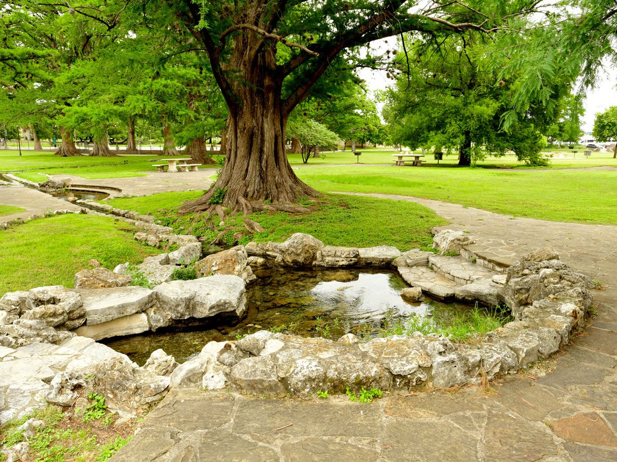
Although San Pedro Springs Park has officially been a park for nearly 300 years, it’s been an informal gathering place for much longer. Before Spanish colonists discovered the park’s thermal springs in 1709, they were a favorite meeting place for Indigenous peoples who resided in the Southwest for thousands of years.
San Pedro was officially designated as a park in 1729 when King Philip V of Spain declared it to be public land. As the springs provided essential water to the community, the park was first used for farming and encampment, before later becoming a recreational site. Today, the park’s thermal water source is still a major draw, with a public pool fed from an aquifer. Other park amenities include a gazebo, a skate park, tennis courts, and a library.
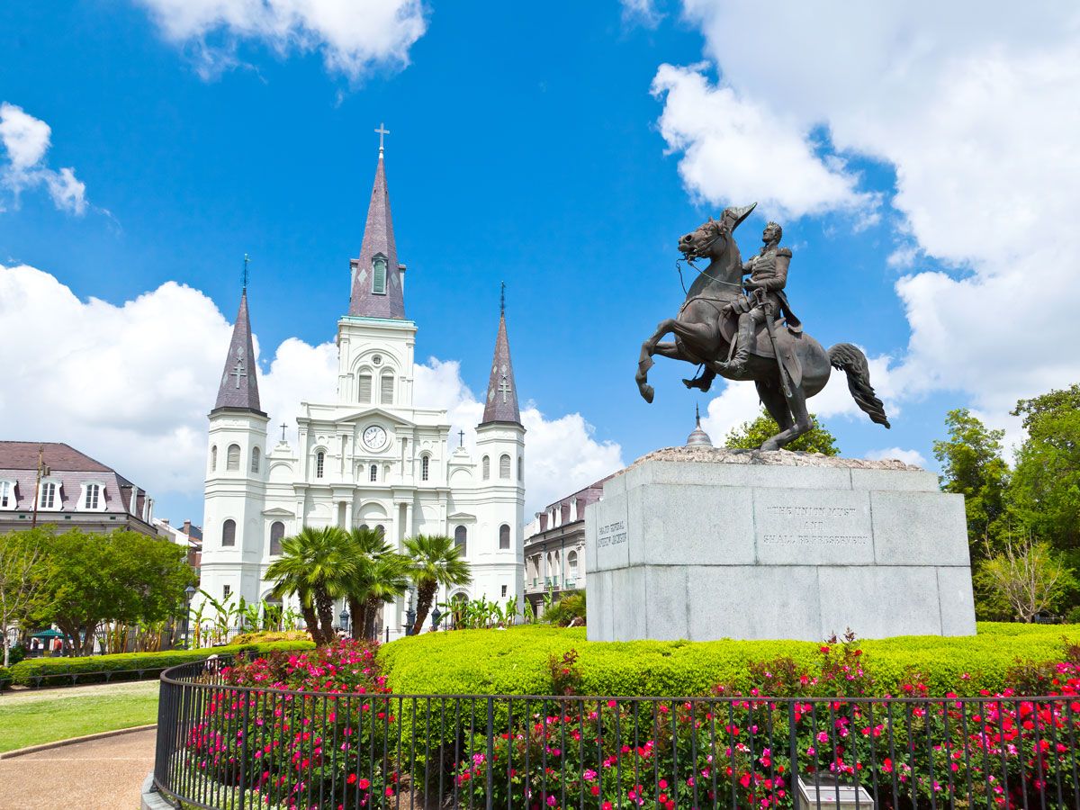
4. Jackson Square – New Orleans, Louisiana
Photo credit: gary718/ Shutterstock
Jackson Square’s location on a bend of the Mississippi River was no accident. In 1718, French colonists, with help from local Native Americans, strategically selected the river portage to be the capital of the Louisiana territory. Three years later, Place d’Armeswas established as one of the region’s first public parks. The park’s pleasing, symmetrical architecture is thanks to the French architects who designed the central square. The square was a gathering place for French colonists to congregate, attend religious services, and access the port, while soldiers could often be seen practicing military formations on the grass.
In 1851, the park was renamed for General Andrew Jackson, the hero of New Orleans in the War of 1812. As an open-air art colony, it has long since been a haven for artists who are permitted to sell their works within the park.
When William Penn first designed Philadelphia in 1683, his “greene country towne” highlighted the importance of public spaces. Formerly known as “North Publick Square,” Franklin Square was one of the original parks spaced across Penn’s city plan.
Throughout its tenure, Franklin Square has had many iterations, including a cemetery, a cattle pasture, ammunition storage, and a parade ground. The park’s landmark foundation was built in 1838 and remains the nation’s oldest public water fountain. Nearly a decade later, it was also the site where the country’s unofficial park mascot — the urban gray squirrel — was first introduced to public spaces.
Since being restored in 2005, Franklin Square has added a carousel, a mini golf course, a burger joint, and choreographed light and sound fountain shows, which are timed to the machinations of the park’s historic waterworks.
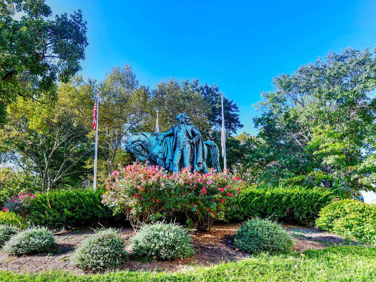
Dating back to 1667, Washington Park was first commandeered by English Puritans, who used the land communally to tend to animals and referred to it as “North Common” or “Upper Green.” It wasn’t until after the Revolutionary War, in 1795, that the land officially became a park named for George Washington.
Since then, Washington Park has become a cultural epicenter in Newark, surrounded by notable institutions such as the Newark Museum of Art, the Newark Public Library, and Rutgers University School of Law. Historical sights within the park include Washington’s Retreat Marker, which displays the route of Washington’s army when they marched through New Jersey, and the nearby statue of the famed general and his horse. The park also contains the oldest statue in Newark, which dates to 1890 and pays homage to Seth Boyden, the American inventor who created patent leather.
Established in 1634, Boston Common is the oldest public park in the U.S. The park’s 44 acres were initially purchased by Puritan colonists who needed a communal pasture for cows. Over the years, Boston Common was also used for military training, town assemblies, and public hangings from the Great Elm. The park played a pivotal role during the Revolutionary War, serving as the site of the colonial militia muster and later an encampment for the Redcoats. Today, it is fittingly home to the Central Burying Ground, a historic cemetery that contains both British soldiers and patriots.
To honor its history, Boston Common marks the start of the Freedom Trail, a historic walking trail that traverses Boston’s many sites of historic significance. Events like Shakespeare on the Common and the Citywide Arts Festival draw large crowds, as do the public assemblies and peaceful protests that have historically taken place in the Common.
Advertisement
More from our network
Daily Passport is part of Inbox Studio, an email-first media company. *Indicates a third-party property.
Geography •September 26, 2023•Updated: September 26, 2023
By Daily Passport Team
Author
Daily Passport Team
Daily Passport writers have been seen in publications such as National Geographic, Food & Wine, CBC, Condé Nast Traveler, and Business Insider. They're passionate about uncovering unique destinations and sharing expert tips with curious travelers.
There are millions of place names on Earth. Some boast impossibly long, difficult-to-pronounce names — such as Llanfairpwllgwyngyllgogerychwyrndrobwllllantysiliogogogoch, the name of a community of villages in Wales. At the other end of the spectrum are some town names that, remarkably, are just one or two letters long. Discover seven places with some of the shortest names in the world and the stories behind them.
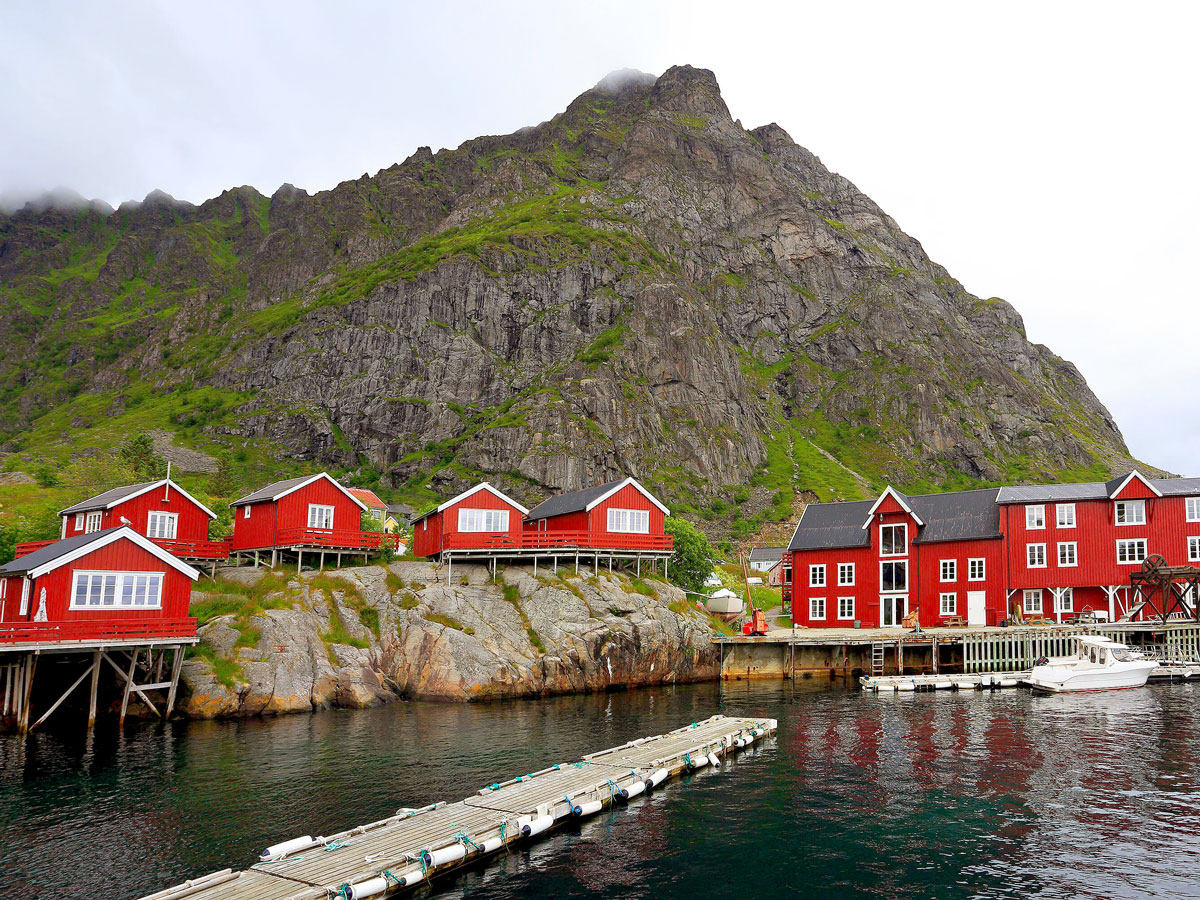
At the southern end of the Lofoten archipelago in northern Norway, there’s a small village known by just a single letter: Å. Pronounced like the “o” in “born,” “Å” is one of eight vowels in the Norwegian alphabet. It’s also an Old Norse word meaning “small river.” Only about 150 people live in the village, which is known for both fishing and tourism. (Among other things, it’s home to both the Lofoten Stockfish Museum and the Norwegian Fishing Village Museum.)
Interestingly, the Å in Lofoten is not the only Å in Norway; at least six other towns have the same name, but Lofoten’s Å is the most popular, likely because of the scenery and climate of the islands. The weather is mild, the mountains are large, and in the summertime, you can experience days with up to 24 hours of sunlight.
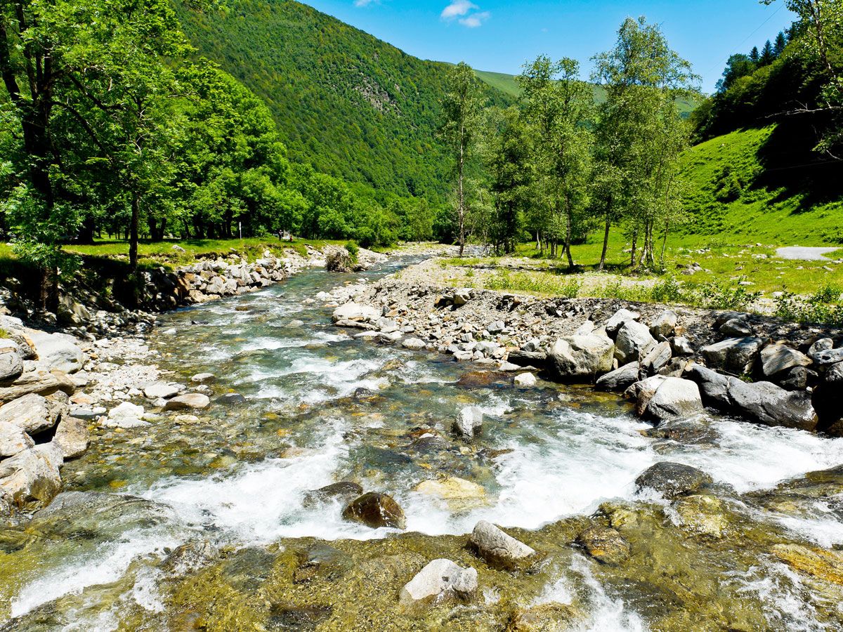
Oô is a commune in the Haute-Garonne department of France, close to Bagnères-de-Luchon in the Pyrenees Mountains. That helps put the name of the town in context, as “Oô” translates to “high mountain” in the regional dialect. Its main feature is the picturesque Lac d’Oô, a glacial lake that was turned into an artificial lake by a dam built in 1921. The lake covers approximately 103 acres and is surrounded on all sides by steep slopes covered in greenery.
It also sits below a waterfall that pours water down about 900 feet. The beautiful scenery makes the lake especially popular with hikers, who follow a path across the Pyrenees Mountains, past the lake, and then into Spain, which borders Oô to the south.
Y, a tiny commune in northern France, has only two main streets, which come together to form the shape of the letter “Y” — hence its abbreviated name. The population is similarly small; it currently has around 90 residents, and at the height of the town’s density, in 1866, only 226 people lived there. Villagers call themselves Upsiloniennes, a reference to the Greek letter upsilon, which — like the commune’s roadway layout — resembles the letter “Y.”
The commune’s main claim to fame is its name, but it also experienced a brief period of internet notoriety for another reason. It became known as “the Place of Death” in the 2000s, thanks to a genealogist’s error when inputting the place of death for people. That mistake led to a number of records showing that a person died in Y when they probably had never even been there.
In central Finland, on the Gulf of Bothnia and just north of Oulu, travelers can stop at Ii, a municipality with nearly 10,000 people. The community was founded in 1445 as a trading center dealing in peat, salmon, and fur. Its name, the shortest in all of Finland, comes from an old Sami word, “iddja” or “ijje,” which translates to “night.” Ii is currently working on a special goal: to be a zero emission and completely waste-free community. The town is already well known in Nordic countries for its sustainability efforts; its goal for 2020 was to cut carbon emissions by 80%, well ahead of goals set by the European Union.
Aa is a village in northern Estonia, right on the coast of the Gulf of Finland. It dates back to the 1200s but is perhaps best known today by Estonian crossword puzzlers, as it’s a common answer to crossword clues in the country. Its popularity was solidified in 2019, when an Estonian puzzle magazine asked readers to vote for what should be the new capital of Estonia, based on towns and villages with short names that were often crossword answers. Aa won by a landslide. The town has an old manor house, built in the 1400s, that’s now a care home, plus a chapel in a former garden pavilion, and a roughly 700,000-square-foot nature park.
Hum, Croatia, is one of the smallest towns in the world, with a diminutive name to match. As of 2011, its population was only about 30, and the village itself is contained mostly within a set of medieval stone walls. It’s located in the northwest part of Croatia, near Glagolitic Alley — a road lined with 11 large stone sculptures representing the Glagolitic alphabet.
Hum itself has only two streets, both paved with cobblestone and very short, along with a restaurant, two churches, a castle, and some souvenir shops. It’s a medieval village, and much of the architecture from earlier centuries remains today, including a church tower built in the 1500s and a baroque church constructed on the site of an earlier church in the 1800s. There’s also a pair of big copper doors at the town gates, with Glagolitic inscriptions welcoming visitors. Hum follows old traditions as well; a new mayor is elected annually by only the men in town, who cast their votes using wooden spoons.
Ny, Belgium, is located in the Province of Luxembourg in Wallonia, the French-speaking region in the southern part of the country. A member of Les Plus Beaux Villages de Wallonie (“The Most Beautiful Villages of Wallonia”), which seeks to preserve and enhance the landscape and heritage of the area, Ny is a hamlet of historical architecture and rural charm.
A limestone castle-farm in the village dates back to the late 1600s and serves as a backdrop for the town’s annual medieval tournament reenactment, but some infrastructure is even older. There’s a mill from the 1300s, for example, that still has its wheel intact. The town also has a number of drinking fountains and water troughs that date back to the 1700s, as well as a neo-Gothic church and presbytery. About three miles away are the Caves of Hotton, where visitors can go more than 200 feet underground to explore a maze of caverns.
Advertisement
More from our network
Daily Passport is part of Inbox Studio, an email-first media company. *Indicates a third-party property.
Beyond Big Ben: 15 Under-the-Radar London Landmarks To Visit
By
Daily Passport Team
Read time: 11 minutes
September 26, 2023
Updated: December 13, 2024
Beyond Big Ben: 15 Under-the-Radar London Landmarks To Visit
Culture •September 26, 2023•Updated: December 13, 2024
By Daily Passport Team
Author
Daily Passport Team
Daily Passport writers have been seen in publications such as National Geographic, Food & Wine, CBC, Condé Nast Traveler, and Business Insider. They're passionate about uncovering unique destinations and sharing expert tips with curious travelers.
Tourists flock to London to visit iconic landmarks such as Big Ben, Buckingham Palace, Westminster Abbey, and the Tower Bridge — and for good reason. These fascinating, history-filled sites are an essential part of any first-time visit to the English capital. But if you’ve already checked these attractions off your list, London offers a wealth of hidden treasures that are every bit as interesting. From quirky museums to serene gardens, here are 15 under-the-radar London landmarks to check out.
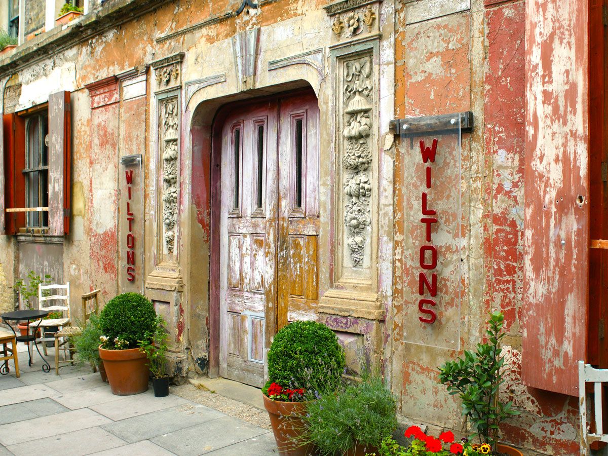
Wilton’s Music Hall in London’s East End is the world’s oldest surviving grand Victorian music hall. Opened in the late 1850s, the storied venue brought the glitz and glamour of the West End to a working-class audience in the East End. Performances typically included sing-alongs, variety routines, and musical comedy shows. During the Victorian era, Wilton’s was London’s premiere venue for live performances, but after a fire in 1877, the building was repurposed to become a Methodist mission and then a warehouse.
Troubled by the hall’s planned demolition in the 1960s, some of the era’s top showbiz personalities, including Spike Milligan and Peter Sellers, fought to save the iconic structure. Today, the building again serves as a venue for theater performances and concerts and retains much of its original charm and character.
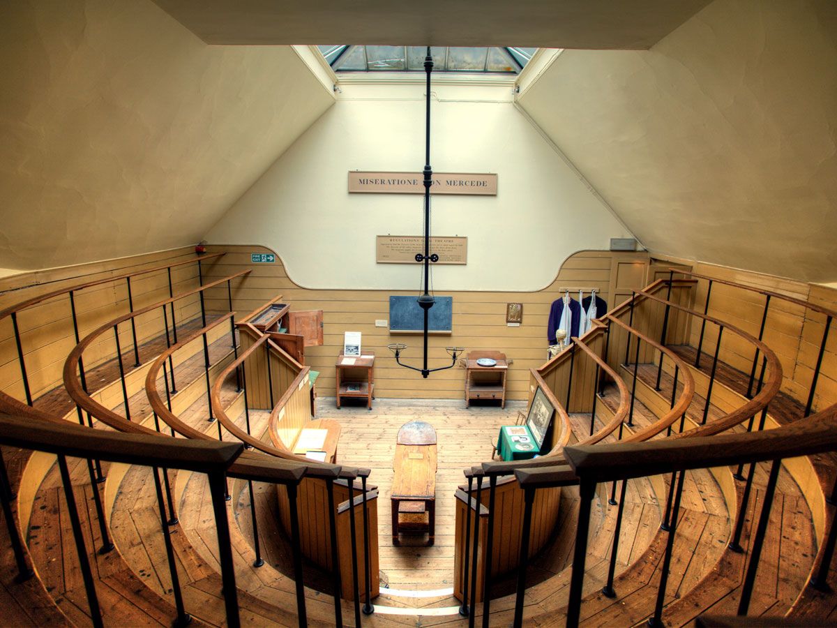
The Old Operating Theatre lay hidden for many years until it was uncovered during construction on St. Thomas’ Church in the London borough of Southwark. The area was actually the original site of the old St. Thomas’ Hospital, and the operating theater took surgery out of the ward and into a dedicated space in the attic. Before the days of antiseptics and anesthesia, operations were bloody and painful, so conducting the procedures far from other sick patients was crucial to maintaining an orderly facility.
The theater also served another purpose, however. It was a teaching space, so the tiered seating would have been occupied by medical students keen to observe techniques. Today, the building operates as a museum, which visitors can reach via a spiral staircase, and serves as a reminder of the advances of modern medicine.
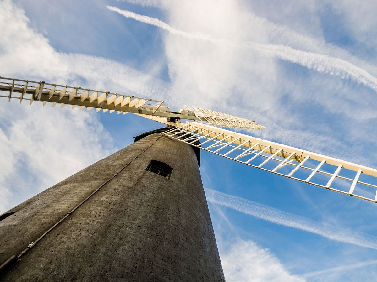
Before London became the sprawling city it is today, it was a series of villages. One of those villages, Brixton, retains its historic windmill. While such structures are common in the English countryside, they’re rare in urban locations. The one in Brixton used to be known as Ashby’s Mill and was built in 1816. Its sails harnessed the power of the wind to mill flour until the 1860s, when the business moved to a watermill in the Surrey village of Mitcham. But when the lease expired, Ashby’s moved back to its original site, using steam and then gas to modernize and increase productivity.
The mill did considerable trade supplying London’s bakeries and restaurants with flour until it finally closed in 1934. These days, it’s the centerpiece of a city park, restored by a committed team of volunteers. Guided tours of the structure take place on open weekends from April to October, when you can learn about the business and watch flour being milled.
London’s congested streets created a bit of a headache when it came to ensuring that postal deliveries made it on time, so engineers came up with an unusual solution — an underground railway. From 1927 to 2003, the “Mail Rail” carried millions of letters across the capital, from Paddington in the west to Whitechapel in the east. Though it’s no longer in use commercially, the train reopened in 2017 as a visitor attraction run by the Postal Museum.
Take a ride on a tiny train to experience the tunnels for yourself. Interactive exhibits give visitors the opportunity to sort the mail on a moving train — courtesy of a realistic simulator. Above ground, you can learn more about the Royal Mail’s history and how stamps are designed.
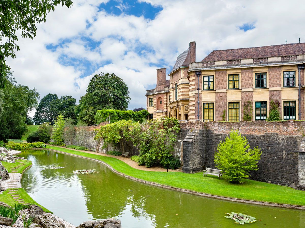
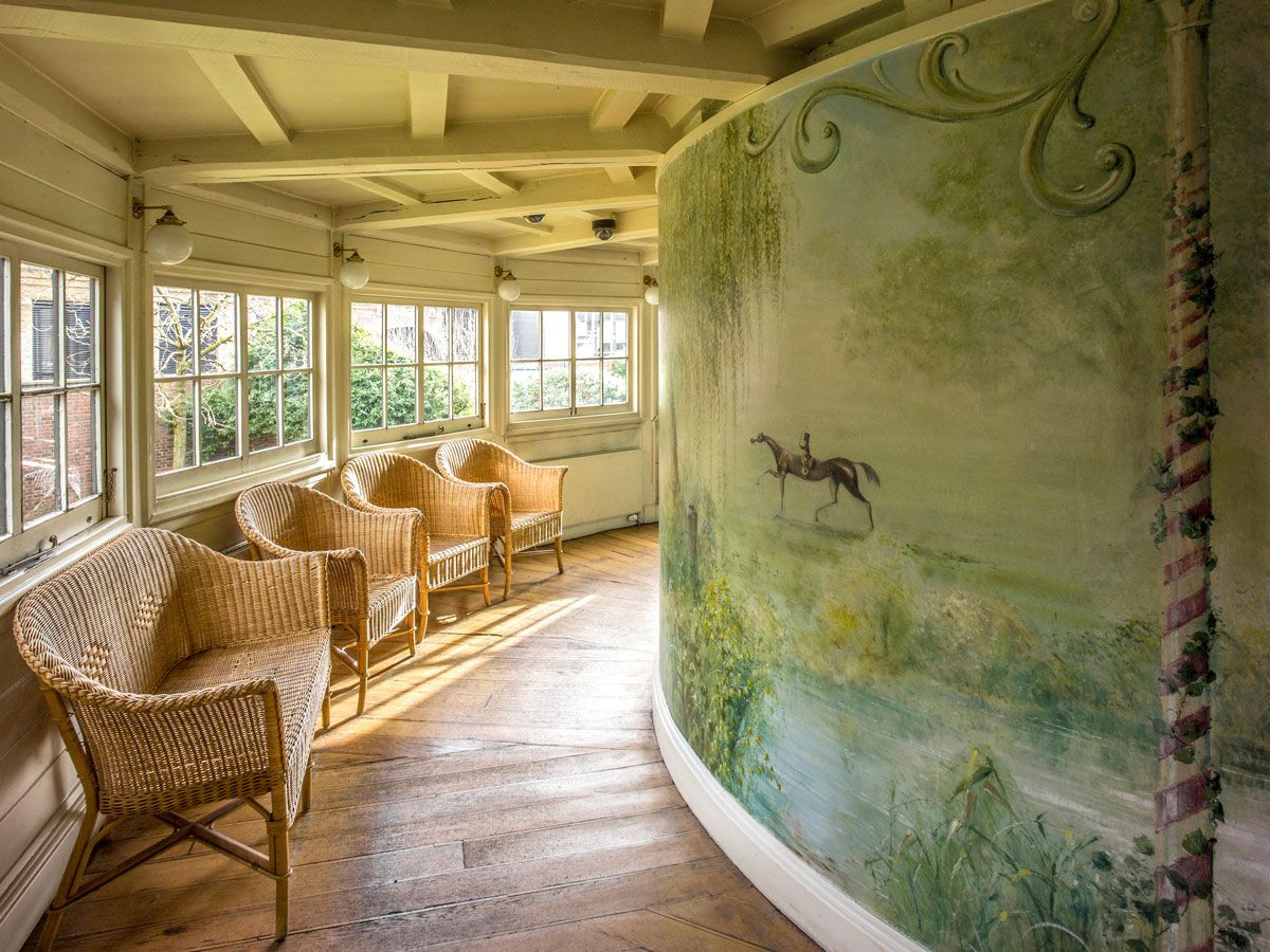
While a steady stream of tourists makes it to Buckingham Palace, Eltham Palace receives considerably fewer visitors. Located south of the Thames in the borough of Greenwich, this historic gem in suburbia began as a 13th-century manor house and was later gifted to the royal family. King Edward IV was the monarch responsible for adding the Great Hall, which is all that remains of the medieval estate.
King Henry VIII expanded Eltham so it could accommodate his large entourage, but the greatest transformation came in the 1930s. Wealthy couple Stephen and Virginia Courtauld are to thank for the extravagant Art Deco-style interior; they took a maximalist approach to design, even creating a rainforest-themed room for their pet lemur Jongy.
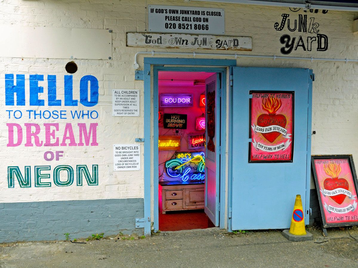
London’s answer to the Neon Museum in Las Vegas can be found in Walthamstow, one of the city’s easterly neighborhoods. “God’s Own Junkyard” is a treasure trove of salvage; the collection includes neon signs, movie props, and fairground lighting. Many of the pieces are the work of the late Chris Bracey, an exceptionally talented lighting designer whose art was featured in movies such as Batman (1989) and Bladerunner (1982).
Bracey learned his extraordinary craft from his father, who was London’s first neon sign maker in the 1950s, and later opened his premises to curious members of the public in 1978. Tucked away on the Ravenswood Industrial Estate between a car mechanic and a microbrewery, the collection was soon credited as being one of London’s quirkiest, most remarkable, and colorful attractions.
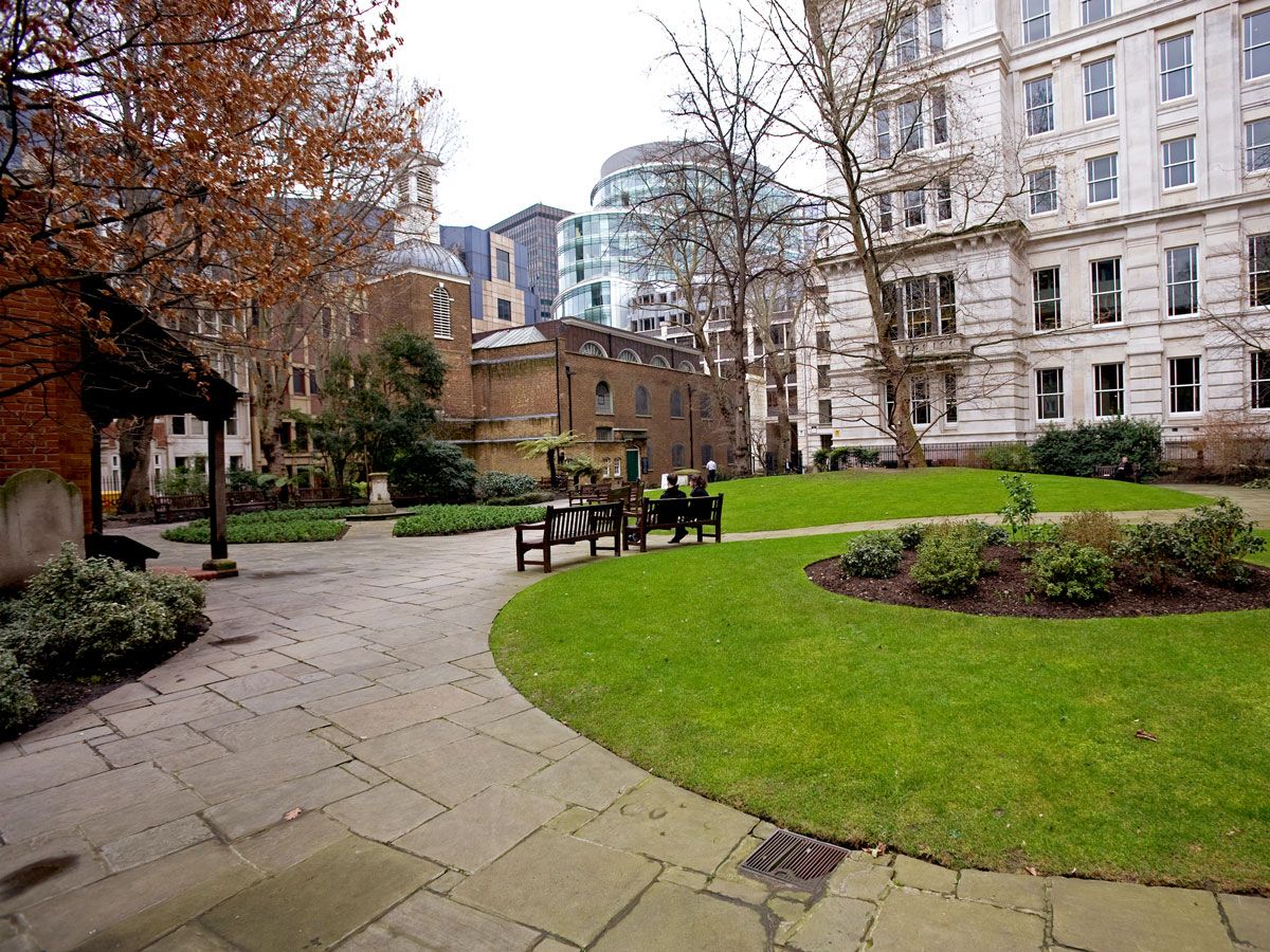
Postman’s Park was built at the end of the 19th century on top of what was once the former St. Botolph’s Without Aldersgate Church. The peaceful greenspace is best known for George Frederic Watts’ Memorial to Heroic Self-Sacrifice, which was unveiled in 1900. A series of memorial stones have been added over the years to commemorate acts of bravery and courage by ordinary folks. Each stone is dedicated to someone who lost their own life while trying to save another.
Another unique garden in the park is the grounds of the former church of St. Dunstan-in-the-East. Sir Christopher Wren, the architect responsible for St. Paul’s Cathedral, designed some of it. During World War II, the church suffered extensive damage. Wren’s steeple and tower survived, but the Church of England decided not to repair and reopen the building. Instead, the bombed ruins were redeveloped as a beautiful garden.
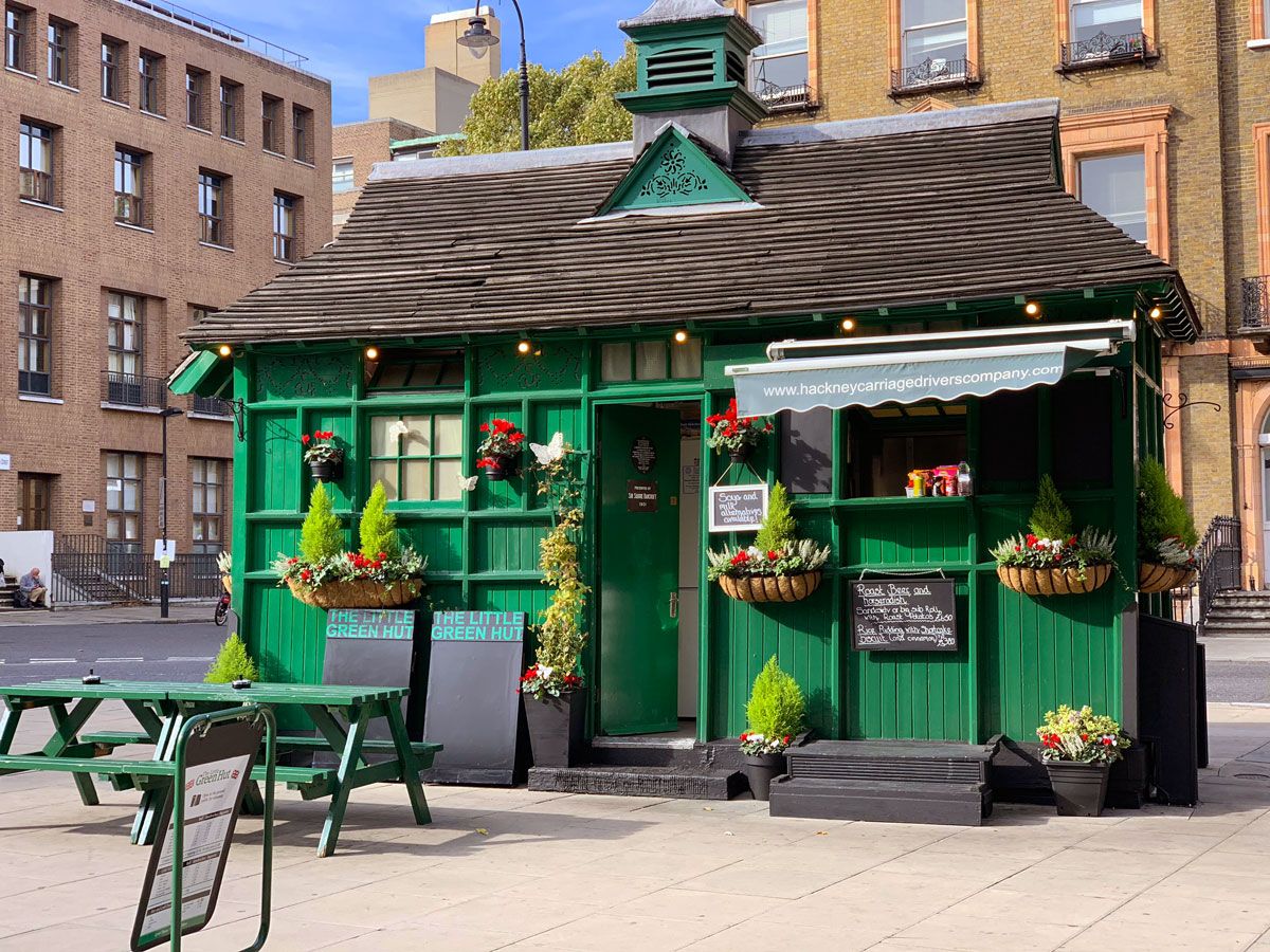
There are few London sights as iconic as the capital’s black cabs. But while you’ll see them on every street, you’ll have to put in a little more legwork to track down the 13 remaining cabmen’s shelters. These little green huts were a response to a tricky problem: In bad weather, cabbies often took shelter in pubs. As driving while intoxicated was prohibited, the idea was born to create somewhere for cab drivers to get an affordable meal and a cup of tea during their shift.
The first shelter opened in St. John’s Wood in North London in 1875. More followed, though since then, many of the structures have fallen victim to road widening and traffic management schemes. Today, some of the shelters remain; Cabmen’s Shelter in Russell Square is one of them. Other shelters still serve cabbies at Grosvenor Gardens, Embankment Place, and on Warwick Avenue. Most of the shelters enforce a cabbies-only rule inside, but if you can manage, it’s worth a peek.
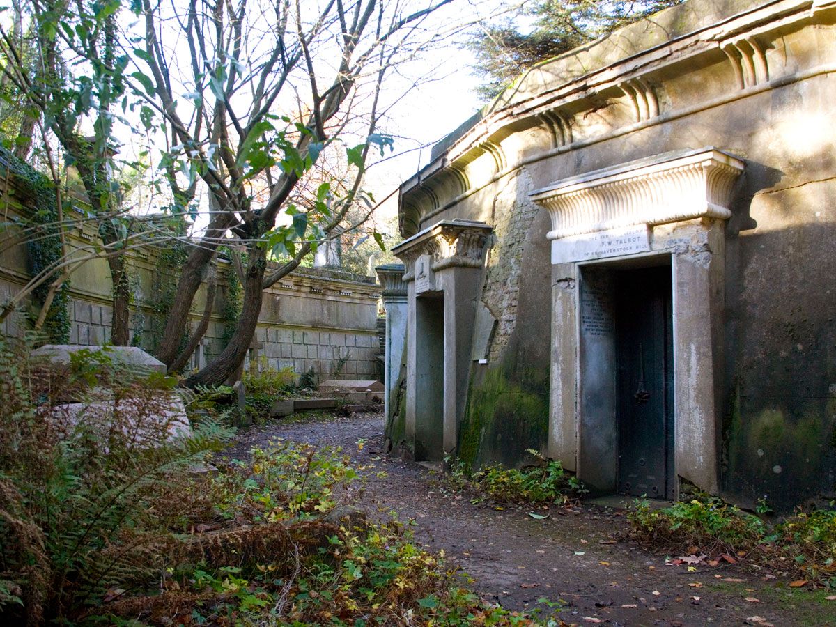
Highgate Cemetery is a bit of a trek from central London but well worth the effort, particularly if you take one of the excellent guided tours along the tree-lined paths. The cemetery is home to the graves and tombs of many notable Londoners; Karl Marx was buried here, as were scientist Michael Faraday, authors Douglas Adams and Beryl Bainbridge, artist Lucian Freud, pop impresario Malcolm McLaren, and comedian Max Wall.
Another notable cemetery can be found in Kensal Green. This atmospheric place was styled after Père Lachaise Cemetery in Paris. It is the final resting place of authors Anthony Trollope, Wilkie Collins, and William Makepeace Thackeray; Niagara Falls tightrope-walker Charles Blondin; Victorian engineer Isambard Kingdom Brunel; and the inventor of the computer, Charles Babbage.
Formerly the Geffrye Museum, the Museum of the Home reopened in 2021 following a refurbishment and rebrand. Located in Hackney, East London, the building houses a fascinating collection of exhibits that chart the changes in Britain’s domestic interiors over the past four centuries. Faithfully recreated room sets bring history to life, from a garish 1970s living room to a genteel parlor that looks just as it would have in 1695.
The museum also has a series of gardens that exemplify fashions such as Elizabethan knot gardens and the informal cottage gardens embraced by the Arts and Crafts movement. You might even be inspired to create a heritage space for your own home after your visit.
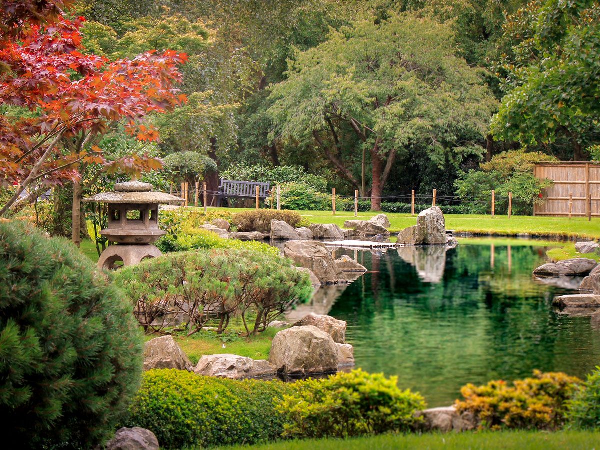
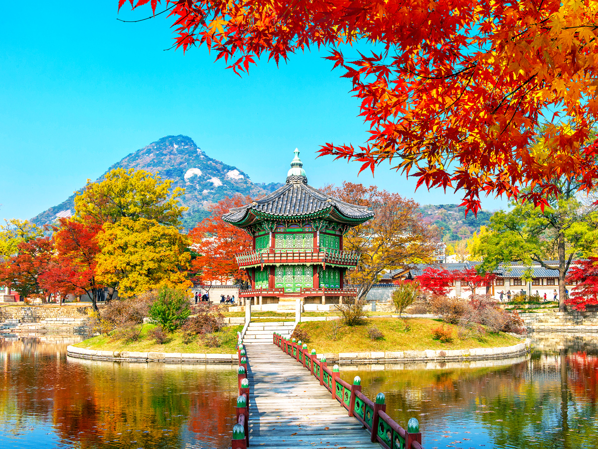
One of London’s most unusual gardens lies in Holland Park in West London. As its name suggests, the Kyoto Garden takes its inspiration from Japan, but what you might not realize is that it was a gift from the city of Kyoto to mark the friendship between the two countries. This serene oasis features tiered waterfalls, a koi-stocked pond, and, of course, the stone lanterns and colorful maples commonly found in Japanese gardens.
The garden is a joy to wander through, though you’ll need to share the tranquil space with a muster of peacocks. Holland Park is also home to the Fukushima Memorial Garden. It’s a place for quiet contemplation and reflection, designed to demonstrate Japan’s gratitude to the British for their support following the devastating earthquake in 2011.
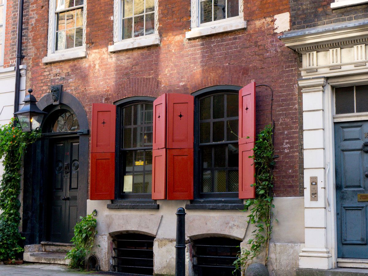
London has a wealth of Georgian architecture. Among the best preserved streets to see this iconic style are Roupell Street near Waterloo, Little Green Street in North London, and East End addresses, such as Fournier Street and Elder Street. But if you’re keen to peek beyond the façades, you’ll need to head to Dennis Severs House on Folgate Street near Spitalfields Market. This house, open to the public as a museum, dates to 1724.
After Californian-born Dennis Severs bought the property in 1979, he set about transforming it into an accurate representation of what it would have looked like as the home of an imaginary family of Huguenot silk weavers. Weekly candlelit tours are a multi-sensory experience which evoke the past. Make your way to nearby Brick Lane afterward for further insight on how immigrants have shaped this multifaceted neighborhood.
This century-old Dutch barge was repurposed as a North London bookstore. Tethered on the Regents Canal close to Kings Cross Station, every inch of this historic vessel is now crammed with new and used books. This is a place to come without a plan. Browse Paddy’s collection and you might stumble on something unexpected: cult, classic, children’s, and contemporary books are all here waiting for you to peruse. Special events, from poetry readings to live music performances, are a reminder of why this place is so much at the heart of its community.
Afterward, wander over to Coal Drops Yard, where you’ll find plenty of places to sit and read. Consider buying your coffee from Redemption Roasters, a café chain with a social conscience. They roast their coffee inside Her Majesty’s Prison The Mount and help offenders reintegrate after serving their sentence by training them as baristas.
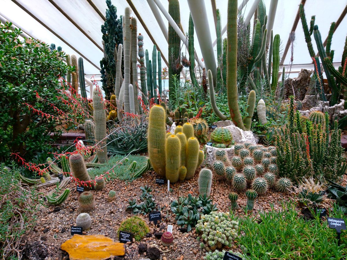
The Barbican was flattened during World War II, and if you want to get acquainted with its brutal yet bold postwar architecture, consider taking one of the fascinating tours of the complex. After you’re done taking in the history of the place, pop in to the Barbican Conservatory, a green oasis amidst all that concrete. This rainforest under glass is as verdant as its more-famous Kew counterpart, the only one larger in London.
Lush plants include palm and banana trees and plenty of floral displays to evoke a sense of being far from England. Check out the terrapins in the water, though you’d be wise to keep your distance; these bad boys were evicted from Hampstead Heath after some antisocial behavior, leading local wits to dub them the “terror-pins.”
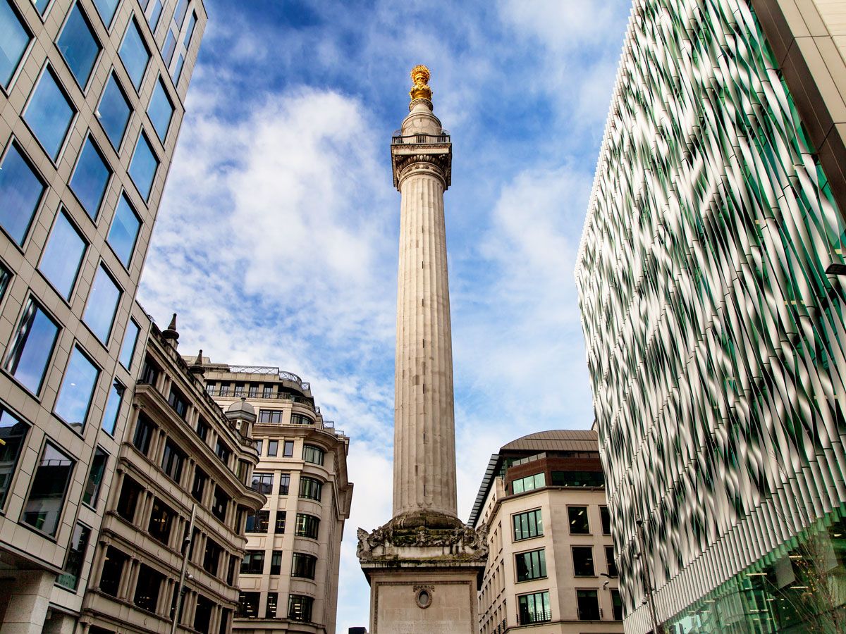
The Great Fire of London ripped through the city in 1666, leaving a trail of destruction and shattered dreams in its wake. The Monument was constructed the following decade to honor those who were lost but also to celebrate the beginning of a new chapter in the city’s history. It is located at the corner of Monument Street and Fish Street Hill.
The height of the column is exactly the same as its distance from the site of Thomas Faryner’s bakery, where the fire started. It’s possible to climb the 311 steps to the top of this landmark. Video images are displayed for those who don’t want to head to the top, but it’s worth the effort for the view of the London cityscape, including skyscrapers such as the Shard, the Walkie Talkie, and the Gherkin.
Advertisement
More from our network
Daily Passport is part of Inbox Studio, an email-first media company. *Indicates a third-party property.
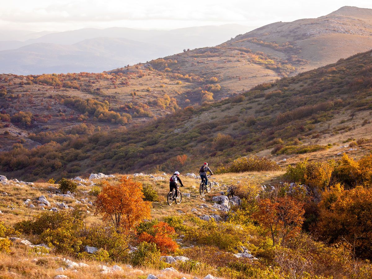
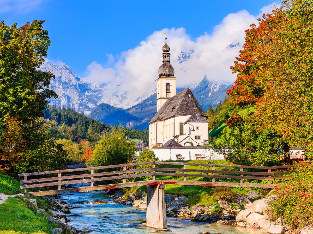
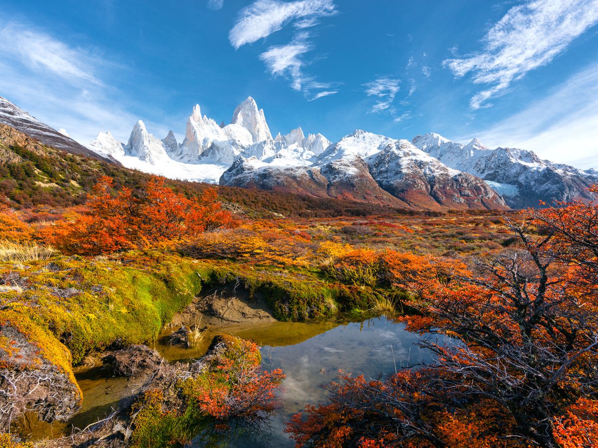
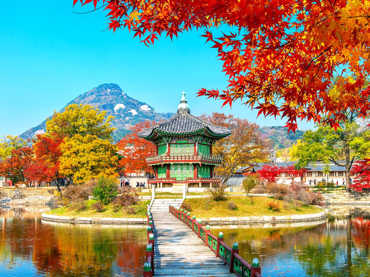
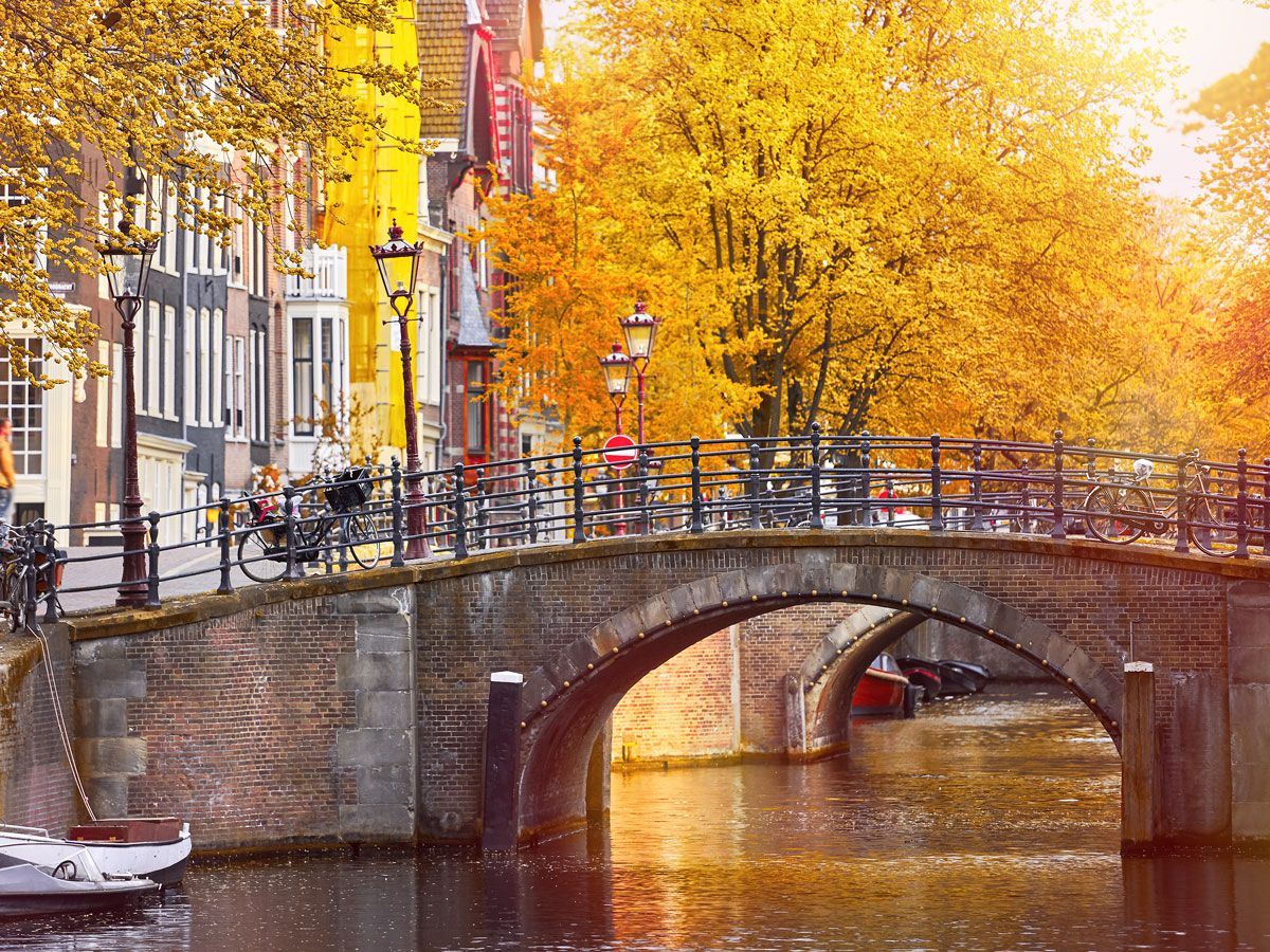
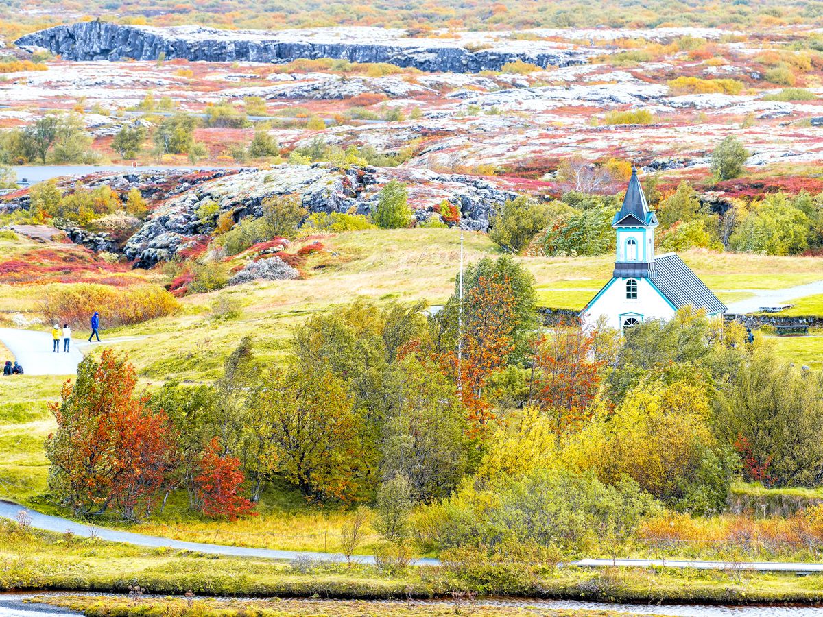
The Best Fall Foliage Destinations Around the World
By
Fiona Mokry
Read time: 7 minutes
September 26, 2023
Updated: September 24, 2025
The Best Fall Foliage Destinations Around the World
Outdoors •September 26, 2023•Updated: September 24, 2025
By Fiona Mokry
Author
Fiona Mokry
Fiona has spent her career exploring the world and working in the travel industry, turning her lifelong passion into a profession. From planning custom trips to sharing stories as a travel writer for publications such as The Discoverer, she’s all about helping others experience the world in a deeper, more meaningful way.
As sunshine and heat are replaced with cooler temperatures and crisp air, many travelers choose to embrace the beginning of fall. What better way to get in the spirit than discovering the world’s most vibrant fall foliage? We’ve already covered America’s best fall foliage destinations (and even the more under-the-radar ones), so now we’re taking a look at 10 places in other countries that shine brighter in autumn.
Tuscany, Italy
Credit: Freeartist/ iStock via Getty Images Plus
The Tuscan countryside charms visitors year-round with its rolling landscapes and vineyard-covered hills, but in autumn, the region is especially appealing. Small villages become even more quaint, and cozy wineries offer exceptional Italian wines and traditional cuisine to complement the sunny, but slightly cooler days.
The best time to enjoy the fall foliage is from late October to early November, a season that also comes with a few unique cultural experiences. In September and October, you can witness the grape harvest (vendemmia), with farmers harvesting their crops, tractors rolling through golden landscapes, and annual wine festivals. Late October and early November usher in the olive harvest, offering opportunities to partake in picking, pressing, and crafting homemade olive oil.
Canada boasts one of the world’s densest forest covers, and the area around the Canadian Rockies in western Canada is a treasure trove of leaf-peeping opportunities. That’s especially true in Banff — Canada’s first national park — along with Jasper National Park in Alberta. (However, Jasper suffered damage from devastating wildfires in 2024, so check the Parks Canada website before you go to see which attractions are open.)
In Banff, you can admire the foliage from pretty much anywhere in the park, including the flat, easy Bow River Trail that starts right in the quaint town of Banff. One of the most popular ways to take in the changing leaves is by hiking the Larch Valley Trail, which winds above Moraine Lake through a dense forest filled with larches that turn a brilliant golden hue come autumn.
In Jasper, you can take to the trails that crisscross Pyramid Bench for views over the tree-covered Athabasca Valley. If the weather’s warm enough, enjoy a picnic with a view on Lake Edith, a glassy basin that shines gold in fall from surrounding foliage. And those who prefer scenic drives are spoiled for choice — don’t miss the long winding route of Miette Road (be sure to stop for a dip in the hot springs) or the Icefields Parkway, the thoroughfare linking Jasper to Banff.
In autumn, Kyoto’s dense population of ginkgo, maple, and cherry blossom trees transform into a spectacle of fall foliage in every corner of the former Japanese capital. The city’s tree-shrouded temples — such as Jo-jakko-ji, Kiyomizu-Dera, and Tofukuji — are all popular tourist attractions year-round, but they are especially beautiful places to peep at the colorful leaves. The trees sweeping above Togetsu Bridge also put on quite a show, as do the groves huddled closely around Kitano Tenmangu Shrine. Plenty of visitors flock to Kyoto for the fall show, so if you’re craving some serenity away from the crowds, Bishamondo Temple makes the trek to the outskirts of town worthwhile.
Summer may be the peak season for tourists to wander the charming and history-filled streets of Edinburgh, but there’s a benefit to holding off on your trip to Scotland until autumn. The tree-lined streets of the Scottish capital transform from green to vibrant golds, browns, and yellows, and the city takes on a magical new appearance. Hit two birds with one stone and stroll around the main attractions — like the Royal Botanic Garden, Lauriston Castle, Edinburgh Castle, and Canton Hill — for a dose of Scottish history coupled with a spectacular display of fall colors. Outside the city, there are several autumn walks that allow you to fully immerse in nature, including the Pentland Hills or Red Moss Nature Reserve.
Croatia is famous for its stunning coastline and lively island-hopping culture, but as summer fades, don’t be too quick to leave. Croatia’s magic continues as the seasons change, especially in the fall. In particular, Plitvice Lakes National Park transforms into a colorful wonderland as its terraced lakes and unique karst formations take on the golden and fiery hues of autumn. Waterfalls spill over moss-covered rocks, fringed by foliage that turns the already-spectacular landscape into something truly breathtaking. Plus, with the summer crowds gone, fall offers a quieter, more peaceful experience — making it the perfect time to fully enjoy the natural beauty of Plitvice Lakes.
Located in southeast Germany, the state of Bavaria is known for its medieval castles and Baroque churches scattered throughout its picturesque countryside. This fairy-tale landscape becomes even more enticing in autumn. Munich, the capital of Bavaria and the original home of Oktoberfest, is a great place for leaf peepers to start. Check out sites like Englische Garten, Nymphenburg Palace Park, and the banks of the River Isar to take in the fall colors. Scenic drives outside of Munich are also plentiful — the Castle Road in Franconia should not be missed for its bright fall foliage and whimsical castles. The German Alpine Road — with its epic mountain views, picnic stops, and picturesque lakes lined with vibrant leaves — is another must-visit.
Torres Del Paine National Park – Chile
Credit: FEBRUARY/ Moment via Getty Images
Fall is an exceptionally beautiful time to visit Chile’s most famous national park. The pristine landscape of Torres del Paine National Park transforms into a tapestry of fiery reds, oranges, and yellows that are particularly vibrant during sunrise and sunset. Bask in the fall colors with treks on the W Circuit, O Circuit, or the shorter (but just as spectacular) Mirador Las Torres. Boat tours on Lake Pehoé or Lake Grey also offer beautiful reflections of the vibrant foliage. Since Chile is located in the Southern Hemisphere, fall in Torres del Paine runs from March to May, with the peak foliage from late March to early April. As a bonus, this shoulder season means fewer crowds and crisp, clear weather.
With nearly 10 million residents, Seoul might not seem like a leaf peeper’s paradise, but from mid-October to mid-November, the Korean capital comes alive with fall foliage. From the streets to the palaces, parks, and the four inner mountains surrounding the city, seemingly every corner of Seoul bursts with vibrant reds, oranges, and yellows.
Hike the trails of the inner mountains — Gwanaksan, Inwangsan, Namsan, and Bugaksan — to fully immerse in the autumn colors. Bukhansan National Park and Namsan Seoul Tower are also popular destinations for vistas of both the city and the fall foliage. Even within the city, streets glow with fiery leaves, and Seoul Forest Park, a sprawling urban retreat in the heart of Seoul, is a great place to take in the colorful scenery.
The beauty of Amsterdam in autumn is underscored by bushy trees blossoming with color, idyllically reflected in the famous canals that crisscross the capital of the Netherlands. Boasting more trees than residents, Amsterdam has long had a commitment to planting trees and creating green spaces that has made it one of the greenest cities in Europe. The result is an abundance of beauty when the leaves of hundreds of thousands of trees start to change in fall.
There are many opportunities to take in the colors within the sprawling grounds of the numerous city parks, such as Vondelpark, Amsterdamse Bos, Park Frankendael, and Amstel Park. As a bonus, fall is a shoulder season for European travel, which means fewer tourists and lower prices. It also kicks off a packed season of festivals and events in the Netherlands.
Iceland’s landscape is a picturesque blend of volcanic formations, dramatic rift valleys, glaciers, and pristine lakes. Among its must-see destinations, Thingvellir National Park stands out as a top UNESCO World Heritage Site and protected area. Visiting between mid-September and early October offers a unique opportunity to access all the highlights of the park — such as walking between the tectonic plates of Eurasia and North America and trekking to Öxarárfoss Waterfall — while relishing the beauty of fall foliage. The vibrant autumn colors strike a contrast with the park’s deep blue lakes, including Lake Þingvallavatn, Iceland’s largest natural lake, while the moss-covered mountains light up in reds and oranges. Fall also marks the beginning of prime northern lights season, making it an ideal time for an Icelandic escape.
Advertisement
More from our network
Daily Passport is part of Inbox Studio, an email-first media company. *Indicates a third-party property.