


12 of America’s Most Underrated Road Trips
12 of America’s Most Underrated Road Trips

Road trips have been a time-honored American tradition since the 1920s, when the iconic Route 66 gave motorists a way to easily and independently travel across state lines. While the U.S. certainly has its share of famous routes, there’s also an endless array of under-the-radar trips that allow roadtrippers to discover new places, learn new histories, experience different cultures, and enjoy scenic vistas from the comfort of their vehicles. Here are 12 such underrated U.S. road trip ideas to escape the crowds on your next vacation.
San Juan Skyway – Colorado

The San Juan Skyway might just be one of the most memorable road trips in the American West. This 236-mile loop through southwestern Colorado connects historic mining towns such as Durango and Telluride. Along the way, drivers who do the full six-hour loop will climb altitudinous alpine roads; weave past waterfalls, lakes, and dense forests; and take in the sights of 14 of Colorado’s rugged 14,000-foot peaks, known as 14ers.
The drive between Silverton and Ouray is particularly thrilling. Known as the Million Dollar Highway, the 25-mile stretch is paved but can make for a tricky drive — the lack of both guardrails and a shoulder will have you clinging carefully to the San Juan Mountains’ steep canyon walls. Dazzling views await at just about every turn, though, and the San Juan route also passes near Mesa Verde National Park, home to Ancestral Puebloan cliff dwellings.
Trail of the Ancients Scenic Byway – New Mexico

Winding through the rugged landscapes of the Four Corners region — where New Mexico, Arizona, Colorado, and Utah all meet — is the Trail of the Ancients. The byway reveals the history of the region’s early Pueblo peoples — ancient cliff dwellings, underground kivas, and etched rock art provide a glimpse into the culture that once thrived in the area.
The Trail of the Ancients offers not only a vast historical and cultural journey, but it also takes travelers through striking desert landscapes filled with massive sandstone buttes, colorful canyons, and expansive skies. At the heart of the trail lies New Mexico’s Chaco Culture National Historical Park, known for its intricate stone ruins of what was once a major gathering place for the Ancestral Puebloans.
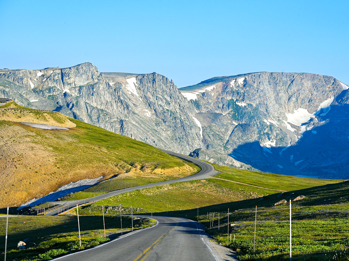
Beartooth Highway – Montana and Wyoming

Few highways in the U.S. climb as dramatically or feel as remote as the Beartooth Highway. Completed in 1936, the drive winds for about 68 miles between Red Lodge, Montana, and the northeast entrance of Yellowstone National Park. At times, the road rises quickly — sometimes at a steep 10% grade — into the Beartooth Mountains, topping out at nearly 11,000 feet above sea level. From there, the landscape opens up into an alpine plateau punctuated with glacial lakes, snowfields that have been known to last well into the summer, and views that stretch across the northern Rockies.
Along the drive, it’s common to spot all kinds of creatures, from mountain goats to grizzly bears to marmots, and the road’s plentiful pullouts make it easy to stop and take in the scenery. Note that the highway is closed for much of the year due to heavy snowfall, but the short summer driving season only adds to the sense of adventure.
North Shore Scenic Drive – Minnesota

Any drive along the Great Lakes is bound to be a beautiful one, but the North Shore Scenic Drive is a true stunner. Stretching approximately 154 miles from Duluth, Minnesota, to the Canadian border, the route offers unparalleled views of the northern shores of Lake Superior — the largest of the Great Lakes and the largest freshwater lake in the world by surface area.
The drive passes through charming towns and rugged coastal landscapes, allowing for opportunities to stop for food and drink while also taking in expansive forests, waterfalls, and beaches studded with colorful agate stones (Minnesota’s state gemstone). Other highlights include Gooseberry Falls State Park, wildlife spotting around the Sawtooth Mountains, and Split Rock Lighthouse, a historic structure perched on a cliff overlooking the stunning lake.
U.S. Route 17 – Virginia to Florida

If you’re craving salt air or serene marshlands rather than mountain switchbacks, U.S. Route 17, also often called the Coastal Highway, is a lovely way to travel the southeastern seaboard. Running from Virginia to Florida, the route passes through historic port cities such as Charleston, South Carolina, and fishing towns including North Carolina’s charming Beaufort (once literally named Fish Towne). You’ll also find long stretches of tidal wetlands, such as the Great Dismal Swamp. Spanning the Virginia-North Carolina border, it’s one of the largest protected natural areas on the U.S. East Coast and a sight that feels worlds away from the nearby Interstate 95.
Route 17 also makes its way through beautiful coastal Georgia. The road skirts historical towns, moss-draped oak forests, and marshes shaped by the tides. Many drivers opt for a detour toward the scenic Golden Isles or a stop in Savannah, whose history and architecture make it one of the country’s most memorable cities to visit.
Columbia River Highway – Oregon

Oregon’s Columbia River Highway, built between 1913 and 1922, was the first planned scenic roadway in the United States. Spanning approximately 75 miles from Troutdale to the Dalles, it served as a blueprint for other paved scenic roadways around the country. The design incorporates arching bridges, rock tunnels, and the beautiful Vista House, where you can take in the view of the mighty Columbia River surging 750 feet below.
From this summit, the road winds down in figure-eight loops that take drivers through mossy forests, past the 620-foot Multnomah Falls, and by scenic vistas of this awe-inspiring river gorge. After you’re finished, it’s easy to understand why they call the highway the “King of Roads” and “A Poem in Stone.”
Cascade Loop – Washington

The Cascade Loop is another one of the most awe-inspiring drives in the Pacific Northwest. Tracing about 440 miles through some of Washington’s most dramatic landscapes, the route starts near Seattle and quickly trades city views for towering peaks as it climbs into North Cascades National Park — often called the “American Alps” for its jagged, glacier-capped mountains. The highway then weaves past turquoise lakes and temperate rainforests before descending toward the wineries of Wenatchee.
From there, the loop heads north. Take in the preserved Western town of Winthrop while making your way through the beautiful Methow Valley region, then return west along the scenic shoreline of the Puget Sound. Along the way, travelers can stop not only for fresh alpine hikes and scenic overlooks, but also for charming seasonal farm stands piled with fresh produce and other local products.
The Blues Highway – Tennessee to Louisiana

Music fans, take note: The Blues Highway — stretching from Nashville, Tennessee, to New Orleans, Louisiana — is a journey deeply rooted in the history of American music. The route, also known as Highway 61, explores Delta Blues landmarks where artists like Aretha Franklin and Elvis Presley recorded iconic songs, the vibrant French Quarter of New Orleans, and the groundbreaking jazz heritage of Preservation Hall.
Of course, the Blues Highway is not without its natural beauty. Mississippi’s Natchez Trace Parkway offers a look into the area’s Native American history, as well as views of southern cypress swamps. And Louisiana’s Tunica Hills, with its spring-fed waterfalls and lush green hardwood, contains some of the state’s best-kept landscapes.
M-22 – Michigan

Tracing the shoreline of Lake Michigan, M-22 is one of the Midwest’s most beloved scenic drives — but one that still feels refreshingly under the radar for many Americans. The highway winds for about 116 miles, mostly along the coast of Michigan’s Leelanau Peninsula. It links beach towns, vineyards, and stretches of open water that almost look like the ocean on a clear day.
Along the way, drivers pass through small harbor communities like Leland — home to the historic fishing district known as Fishtown — and Glen Arbor, a laid-back town near the towering 450-foot bluffs of Sleeping Bear Dunes National Lakeshore. This latter stretch, with its sweeping sand dunes that rise high above the lake, is often the highlight of the trip.
High Peaks Scenic Byway – New York

The spectacular Adirondack Mountains are on full display on a drive along the aptly named High Peaks Scenic Byway. This upstate New York route is a short, but stunning slice of scenery. Coming in at just under 30 miles long, the byway starts in the town of Keene and runs to Lake Placid, leading travelers along the highest peaks of the Adirondacks, by breathtaking bodies of water such as Chapel Pond and Roaring Brook Falls, and through charming towns and dense forests — which are particularly stunning during autumn.
There are plenty of places to pull over and take in the fresh air and scenery along the drive, as well as numerous trailheads for those who want to access more active recreational opportunities such as canoeing, biking, fishing, or cross-country skiing.
Midland Trail – West Virginia

Running east to west across the heart of West Virginia, the Midland Trail follows a historic corridor that once carried travelers through the Appalachians before later becoming part of one of America’s first transcontinental auto trails. Today, much of the route traces U.S. Route 60.
Along the 117-mile trip, make sure to stop at scenic spots such as Hawks Nest State Park, where overlooks reveal dramatic views of the breathtaking New River Gorge and its iconic bridge, one of the longest steel arch bridges in the world. The drive also passes through historic communities such as Lewisburg, whose streets are lined with log buildings and other architecture dating back to the 1700s.
Eastern Sierra Scenic Byway – California

Driving the Pacific Coast Highway up the coast of California is one of the most famous and beautiful road trips in the world. But the Golden State is home to much more than Big Sur scenery — as evidenced by the diverse landscapes of the Eastern Sierra Scenic Byway. Stretching along the eastern side of the Sierra Nevada mountain range, the byway showcases a panorama of alpine lakes, rugged peaks, and desert expanses.
The elevated mountainous terrain also offers breathtaking views of Mono Lake, whose famous salt waters are visible from miles away. Furthermore, the byway offers the opportunity to visit the ancient Bristlecone Pine Forest, home to some of the world’s oldest trees, as well as Inyo National Forest, home to 14,500-foot Mount Whitney — the highest peak in the contiguous United States.
More from our network
Daily Passport is part of Inbox Studio, an email-first media company. *Indicates a third-party property.


