How Often Should You Clean Your Suitcase?
How Often Should You Clean Your Suitcase?

If you’re a seasoned traveler, your favorite suitcase has probably picked up a few scuffs, stains, or scratches on the road. But while some may consider that a point of pride, there’s a difference between weathered and dirty. Wondering how often you should clean your suitcase? Or how to keep your luggage in tip-top shape no matter where you travel? Read on for these essential (and easy) tips on how to actually keep your luggage looking pristine.
Before, During, and After Every Trip

Experts typically agree that it’s best to clean your luggage after every trip. While this may seem like overkill, it’s important to prevent harmful bacteria from entering the home. According to one recent study, the wheels of an average suitcase are 58 times dirtier than a public toilet seat, and the bag’s base and handle are also rife with bacteria. It doesn’t matter if you were gone for two days or two weeks — you don’t want to bring these germs inside.
When you get home, it’s a good idea to leave the suitcase in the driveway, garage, or hallway (if you live in an apartment building, for example). Then, head inside and get whatever appropriate cleaning supplies you’re planning to use (more on that below). When you come back out to give it a thorough clean, pay special attention to the wheels, handle, and other exterior-facing touch points.
This advice applies for after a trip, but it’s also useful before packing a bag that’s been sitting in the closet unused for months before a trip. Experts say it’s best to wipe down the exterior of any luggage that’s been sitting untouched for an extended period. The issue here isn’t so much bacteria as it is dust, which you want to remove from both the exterior and interior (with a vacuum).
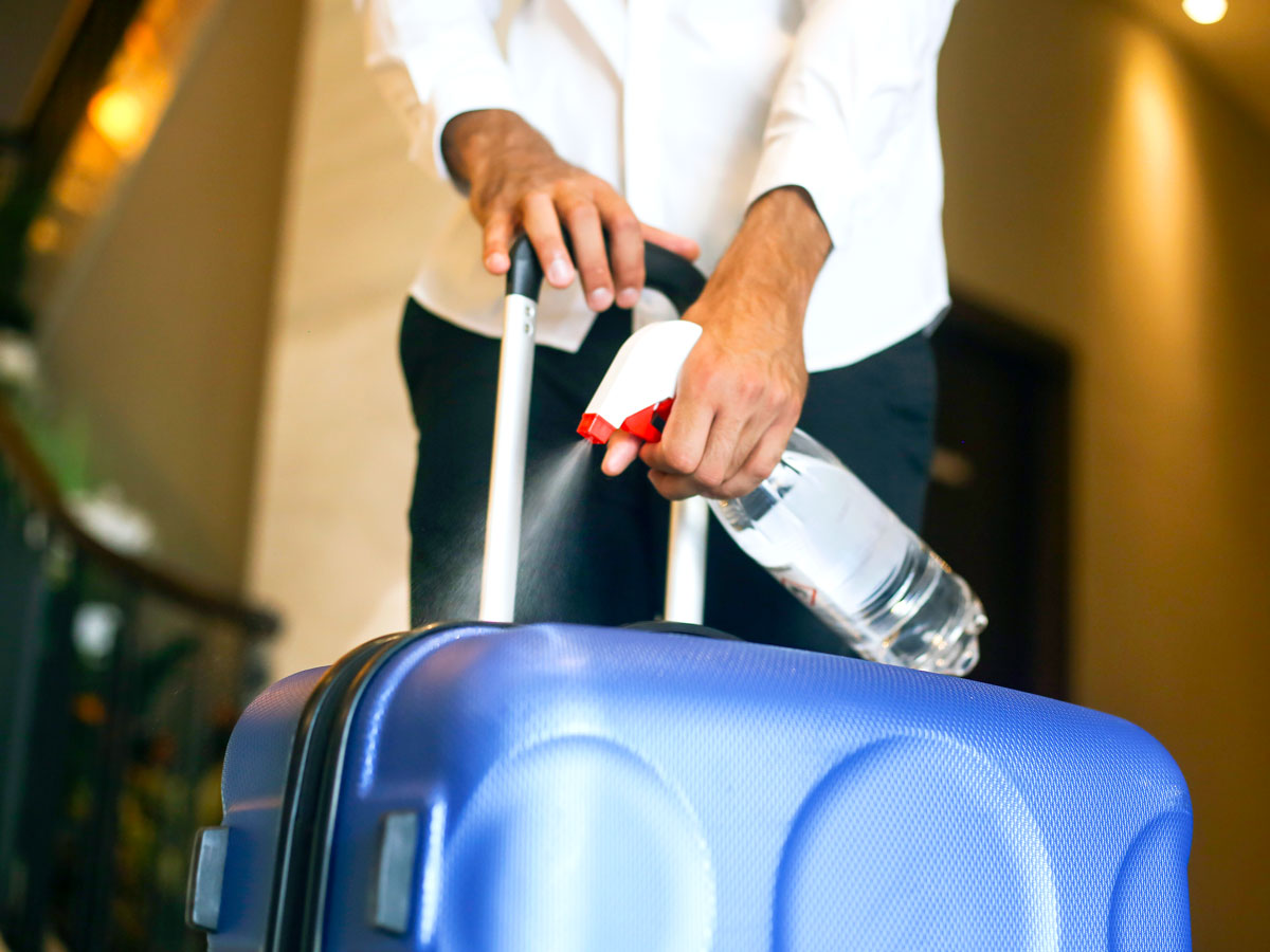
You should also intermittently clean the outside of your luggage (which gets the most dirty) while on vacation, which is why we recommend always traveling with disinfectant wipes. At the very least, make sure to wipe down the handle of your luggage with a disinfectant wipe every now and then, because you’ll be touching this part the most. And when you enter your hotel room, the first place you should put your bag is in the bathtub. That way, you can wipe down the wheels, handle, and exterior.
Cleaning the Outside of Your Luggage

Next, we’ll go over how to actually clean and maintain your luggage. Exactly how to clean your luggage depends on what your particular suitcase or travel bag is made out of, so we’ll break it down by a few types.
While metal or polycarbonate luggage is highly durable, it’s also some of the easiest to show dirt or dust. Fortunately, it’s as easy to clean minor dust and dirt off of this type of luggage as it is for it to acquire it in the first place. All you need is warm (not hot) water, mild soap, and a cloth or rag. Make sure to wash the entire surface, not just the dirty parts, otherwise you can end up with dark spots in the finish. Once you’re done, rinse off the soap residue with damp cloth. Follow this with a dry cloth to remove excess moisture, and you’re good to go.
Nylon or polyester suitcases are lightweight and easy to haul, but they also can be a dust magnet. Some brands will include a bag to cover the luggage when not in use to keep dust off. If yours didn’t come with a bag of its own, just use any bag that fits. Keeping this type of luggage covered is a big part of keeping it looking good as new. That said, if you need to wash it, all you need is a damp cloth or nylon brush. As with hard-shell luggage, make sure to clean the entire exterior, not just any dirty or dusty spots. Once clean, allow the luggage to dry. Don’t place it in sunshine to speed up the process, as this will cause the fabric to fade.
Lastly, leather luggage is meant to age in a way where minor signs of use actually compliment the look, rather than take away from it. If you do need to clean it, though, you can use a non-petroleum-based leather cleaner. Just be sure to check that it doesn’t contain bleach, as this can damage the leather. This is one case where you don’t want to clean the entire surface, unless it actually needs it. Also be sure not to overuse the leather cleaner. Even if you do need to clean the entire bag, do it one section at a time, and make sure to wipe away any residue before moving on to a new section.
Cleaning the Inside of Your Luggage

A simple vacuum should be all you need to keep everything clean inside your luggage. Just be careful to remove everything from the interior first, especially smaller accessories or trinkets that could end up sucked into the vacuum cleaner. If you want to be thorough, make sure to check the pockets and various compartments and vacuum those as well.
Sometimes a deeper clean is in order, whether due to a spill or just from being used over and over. If that’s the case, you can use baking soda with a mixture of vinegar and water. This won’t do much to get rid of stains, but it will help remove any odors your luggage might have picked up over the years.
Dealing With Marks, Scuffs, and Stains

Marks and scuffs will tend to happen far more with hard-shell cases like aluminum or polycarbonate. Fortunately, many of these are minor and can be easily removed. All you need is some spot remover or rubbing alcohol (use a lower percentage variety) and a soft cloth. Using gentle motions should be enough to rub most minor scuffs away. Avoid harsh cleaning agents like those that contain ammonia or acetone, and only treat the scuffed area.
Over time, this type of luggage can start to look dull. Fortunately, this can be easily remedied with the use of a little furniture polish. Just polish the case as you would anything else and it should look closer to new in no time.
When it comes to stains, the major thing to keep in mind is to prevent them from happening in the first place. If you spill a glass of wine on your luggage, for example, quickly dampen a paper towel (newspaper will also work in a pinch) and wipe away the stain before it has a chance to set in. If you can’t do anything about it at the time, use a mild laundry detergent and warm water as soon as you can. You might want to test this on a discrete area first to make sure it doesn’t discolor fabric suitcases.
Unfortunately, there may still be times in which you won’t be able to get your luggage looking as clean as you’d like on your own. In that case, you’ll have to turn to a professional cleaner. Hopefully, though, you’ll have enough tricks in your arsenal to make that a rare occurrence.
Featured image credit: Credit: GoodLifeStudio/ E+ via Getty Images
More from our network
Daily Passport is part of Inbox Studio, an email-first media company. *Indicates a third-party property.