Why This Major U.S. City Will Soon Be Charging Drivers on Its Streets
By
Daily Passport Team
Read time: 3 minutes
January 11, 2024
Updated: January 24, 2024
Why This Major U.S. City Will Soon Be Charging Drivers on Its Streets
Tips •January 11, 2024•Updated: January 24, 2024
By Daily Passport Team
Author
Daily Passport Team
Daily Passport writers have been seen in publications such as National Geographic, Food & Wine, CBC, Condé Nast Traveler, and Business Insider. They're passionate about uncovering unique destinations and sharing expert tips with curious travelers.
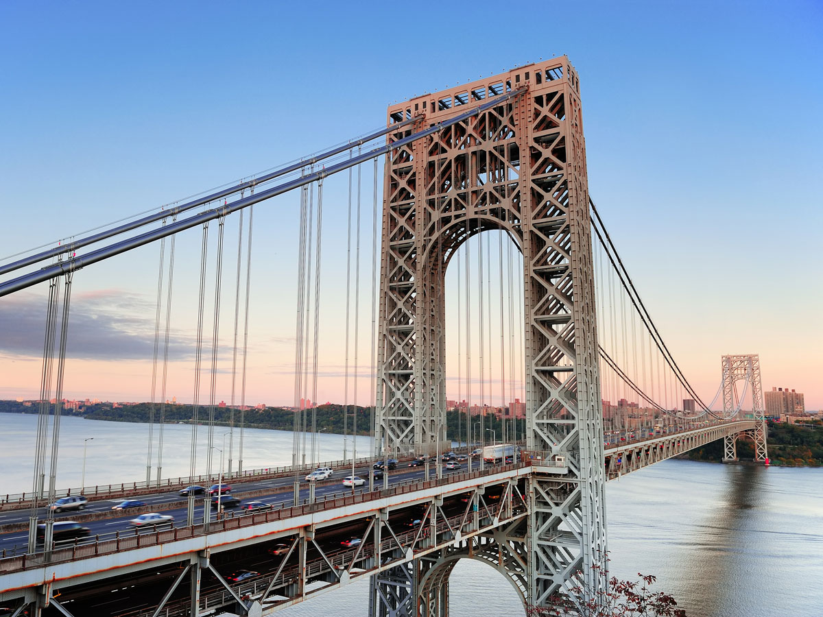
In an unprecedented move, New York City is set to become the first city in the U.S. to introduce wide-scale congestion pricing. This plan includes a significant tax on drivers entering southern Manhattan, which aims to cut down on traffic congestion and in turn benefit the environment. Keep reading to learn more about congestion pricing — and what that might mean for visitors and locals alike.
There are 789 bridges and tunnels located throughout New York City’s five boroughs, plus over 13,000 iconic yellow taxis roaming its busy streets. Additionally, 45% of New York households own a car, with Staten Island having the highest percentage of car ownership among any borough. Manhattan — where the congestion pricing will take effect — is the most densely populated island in the country, and its roads are consistently packed with vehicles. In a 2022 report, New York City ranked as the most congested city in the country — during peak rush hour, drivers moved at an average speed of just 12 mph. In midtown Manhattan, the average speed of a car was just 4.7 mph in a 2018 study.
This plan charges drivers a fee for entering Manhattan’s congestion pricing zone, which includes every thoroughfare located below 60th Street, from the Hudson River to the East River on the other side of the island. Local officials hope to raise $1 billion annually from congestion pricing tolls, which will then be reinvested towards improving public transit infrastructure. New York City’s congestion pricing is set to go into effect in the spring of 2024.
For tourists, getting around New York City will cost the same if you travel through Manhattan by subway or bus. In fact, congestion pricing will hopefully lessen traffic to the point where bus lanes are more free-flowing. However, if you hail a cab, you’ll pay a little more. Taxis will charge an additional $1.25 per ride, while ridesharing apps are set to charge an additional $2.50 per trip.
For tourists and local commuters who rely on their car, it’s a slightly different story. If you enter southern Manhattan from New Jersey or one of the outer boroughs, standard-sized vehicles will be charged $15. Larger vehicles will cost anywhere between $24 to $36, depending on their size, while motorcyclists will pay $7.50.
The good news is that drivers will only be charged once per day between 5 a.m. and 9 p.m. on weekdays, and 9 a.m. to 9 p.m. on weekends. That means even if you’re making multiple trips on any given day, you’ll only be charged a single time. Furthermore, drivers can receive a $5 credit for entering Manhattan through any of the city’s four major tunnels. You can also skirt around paying congestion charges if you remain on FDR Drive or the West Side Highway — the two roads that run along the edges of Manhattan.
While New York City is the first American city to unveil an entire congestion zone, other cities have tinkered with similar concepts. San Diego, California, introduced congestion lanes back in 1998, which undergo variable 25-cent price increases depending on the amount of traffic. Lee County, Florida, took a different approach, offering discounts for drivers traveling during off-peak hours.
Globally, congestion pricing is a more popular phenomenon. London, England, began charging a congestion fee in 2003, which led to an estimated 15% reduction in traffic, plus a 30% reduction in delays. Stockholm, Sweden, joined the fray in 2006, which resulted in an even greater decrease of 20% to 25% in traffic volume.
However, the concept of congestion pricing began in Singapore, which introduced their system back in 1975. The program was later updated to a fully automatic system in 1998, which laid the groundwork for future congestion pricing schemes. Singapore reduced their traffic by an estimated 13% thanks to the scheme.
Advertisement
More from our network
Daily Passport is part of Inbox Studio, an email-first media company. *Indicates a third-party property.
Architecture •January 11, 2024•Updated: January 24, 2024
By Fiona Mokry
Author
Fiona Mokry
Fiona has spent her career exploring the world and working in the travel industry, turning her lifelong passion into a profession. From planning custom trips to sharing stories as a travel writer for publications such as The Discoverer, she’s all about helping others experience the world in a deeper, more meaningful way.
When many people think of alleyways, dark, dingy, and often dangerous corridors come to mind. While some back passages are reserved for dumpsters and loading zones, that’s certainly not the case for all alleyways. From the medinas of Morocco to taverns of Tokyo, here are six locations filled with spectacular and historic alleyways you’ll definitely want to get lost in.
The magical historic walled quarter of Marrakech dates back to the 11th century. The central Moroccan city was once the capital of the Almoravid empire, and its ruling dynasty is credited with crafting its intricate maze of narrow alleyways. Marrakech rose to and fell from power multiple times throughout the centuries, but today it is regarded as a prized center of culture, architecture, and history — and it was recognized as a UNESCO World Heritage in 1985.
Wandering through the old medina, surrounded by ancient ramparts, is an experience like few others. The medina was built entirely from clay, which earns it the nickname of “the Red City.” Each snaking passage is lined with tiny souks selling fragrant spices and perfumes, handmade leather goods, and other handicrafts — making it an ideal spot to buy traditional souvenirs.
For an authentic Turkish market experience, the Kemeralti Bazaar of İzmir should be at the top of your list. Less crowded than the Grand Bazaar in Istanbul, Kemeralti —and the historic covered Kizlaragasi Han Bazaar alongside it — is an ancient shopping center composed of streets and alleys where locals have shopped since the 17th century. Every turn through the stone alleys uncovers another corner of the market, each of which is devoted to different wares. Home goods, children’s items and toys, fabric and clothing, gold and jewelry, and dried goods are just a few of the sections you’ll stumble upon.
While shopping is undoubtedly the main attraction at the Kemeralti Bazaar, don’t skip out on the food. Authentic Turkish cuisine — from kebabs to baklava to Turkish coffee — is served and enjoyed in a lively atmosphere. Plan to spend at least a half day shopping, eating, and perhaps getting lost — though you probably won’t mind.
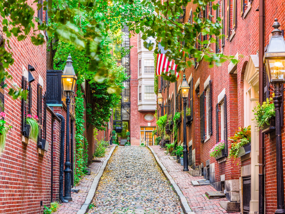
It’s easy to see why Acorn Street is one of the most photographed streets in the country. The charming 19th-century cobblestone lane is framed by narrow brick sidewalks, colonial row homes with cheerful flowers sprouting from window boxes, and antique street lights. The quaint Boston street — tight enough to be considered an alleyway — draws hordes of tourists, photographers, and artists from around the world.
While homes on Acorn Street are worth several million dollars, the origins of the street are much humbler. When it was first built in the 1820s, it housed the neighborhood’s tradespeople and servants. The cobblestones on Acorn Street are original, making it one of the last authentic cobblestone streets in the country.
The end of World War II in 1945 spurred the development of the Tokyo district now known as Golden Gai. At that time, the area around Shinjuku Station’s east exit morphed into a black market known for illicit activities. After the area was cleaned up in the 1960s and 1970s, its six rows of tightly packed alleys hosted cozy izakaya bars that became a haven for intellectuals and artists.
The 1990s saw an economic downturn that closed many of the area’s venues, but entrepreneurs later breathed new life into the area. Today, more than 280 bars (most of which can only accommodate five to six patrons at a time) are crammed into these six blocks, which have retained their historic charm while the rest of Shinjuku has modernized around them.
The medieval walled city of Dubrovnik hasn’t changed much through the centuries, with its limestone buildings, Baroque- and Renaissance-style architecture, cobblestone streets, and labyrinth of alleyways. To get a feel for this jewel along Croatia’s Adriatic coast, start by strolling down Old Dubrovnik’s gleaming main stretch, Stradun. Then duck into any of the offshoot passages that could lead you to a cluster of street cafes, a beautiful medieval church, or a steep stairwell leading to yet another winding passageway.
Hours could be spent wandering beneath the terracotta roofs of the Old Town, but the most historic path in Dubrovnik sits well above them. First constructed in the 13th century, the Dubrovnik City Walls stretch over a mile long and protect the city with towers, bastions, and fortresses that stand up to 82 feet tall. Walking on top of the ramparts offers the best views over the city, the sparkling Adriatic, and the Old Port of Dubrovnik.
The birth of Tunis Medina began when the 16,500-square-foot Al-Zaytuna Mosque was erected in the seventh century. The city expanded slowly around this significant cultural and religious center, and its Old Town remains standing more than a millennium later. Designated a UNESCO World Heritage site in 1979, the Tunis Medina is considered one of the best preserved medinas in the world.
Its 700-plus acres are crisscrossed with alleys, and lined with cafes, shops, hookah bars, and local residences. Ancient mosaiced archways, elaborately decorated doors, and hundreds of monuments — from mosques to mausoleums and palaces — offer compelling evidence that this city was once the wealthiest in the Islamic world.
Advertisement
More from our network
Daily Passport is part of Inbox Studio, an email-first media company. *Indicates a third-party property.
10 U.S. Monuments To Visit That Honor Black History
By
Daily Passport Team
Read time: 7 minutes
January 11, 2024
Updated: February 5, 2025
10 U.S. Monuments To Visit That Honor Black History
History •January 11, 2024•Updated: February 5, 2025
By Daily Passport Team
Author
Daily Passport Team
Daily Passport writers have been seen in publications such as National Geographic, Food & Wine, CBC, Condé Nast Traveler, and Business Insider. They're passionate about uncovering unique destinations and sharing expert tips with curious travelers.
For travelers interested in history, the U.S. is home to hundreds of thousands of monuments that delve into all aspects of the nation’s history, from its Indigenous communities to the early colonial era and beyond. There are also monuments that honor America’s Black history — one that has long been tangled in slavery, segregation, and systemic racism. These fascinating monuments honor the stories that have come out of this challenging, often tragic history, with landmarks across the country that pay homage to the leaders, heroes, and places that have played a crucial role in the fight for justice. Here are 10 of the best U.S. monuments to visit that honor its Black history.
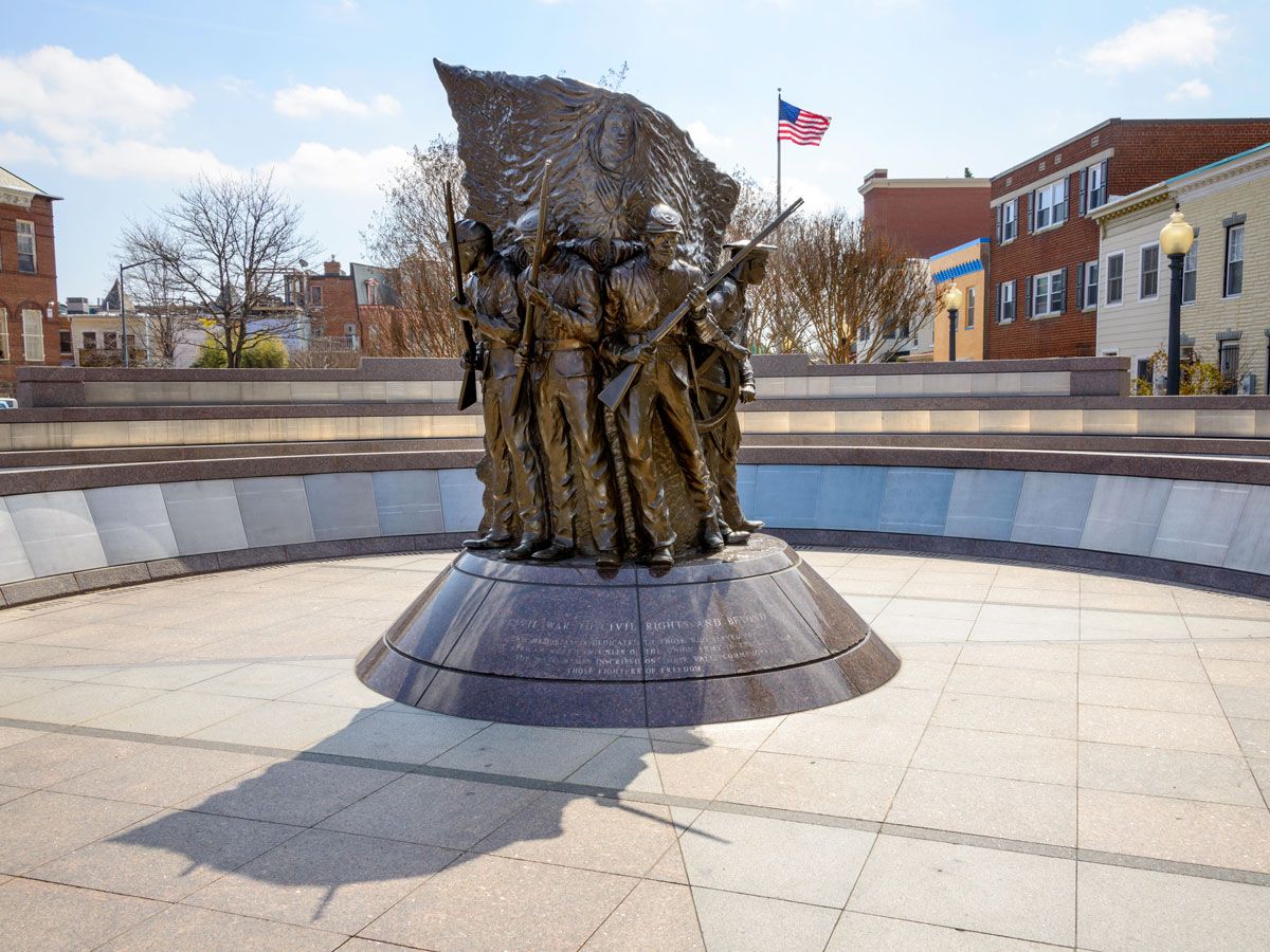
African American Civil War Memorial – Washington, D.C.
While it’s officially part of the National Mall and Memorial Parks, the African American Civil War Memorial is located in the capital’s U Street neighborhood, about 2 miles north. Honoring the Black soldiers and sailors who fought in the Army and Navy during the Civil War, the monument serves as a reminder of how their actions helped free 4 million enslaved peoples. The engraving below reads, “Civil War to Civil Rights and Beyond,” and surrounding the statue is a wall bearing the name of the service men.
The memorial is located next to the African American Civil War Museum. The museum opened in 1999 to shed light on the 209,145 members of the United States Colored Troops (USCT), who helped end slavery and kept America united under one flag, as well as to help revitalize the surrounding neighborhood, which has long been the center of D.C.’s Black history and culture.
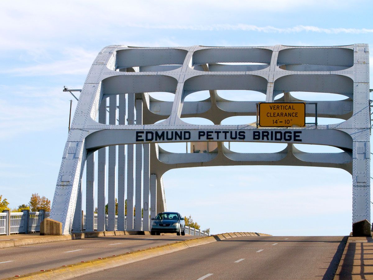
Despite the Civil Rights Act of 1964 granting the equal right to vote, local practices still prevented Black Americans from registering. In protest, activists organized a 54-mile march from Selma to Montgomery, which began by crossing the bridge that spans the Alabama River. Immediately, protestors were met by Alabama State Troopers in a violent confrontation that turned March 7, 1965, into Bloody Sunday. Leading the 600 marchers was then 25-year-old activist John Lewis.
Later that month, the group did eventually make it to Montgomery, thanks to the protection of the National Guard. Lewis returned to the bridge — which has become a symbol of the movement — every year to cross it again. After his death in March 2020, his body was brought across the bridge one last time. Now efforts are underway to put Lewis’ name on the bridge, which currently bears the name of a Confederate general.
George Washington Carver National Monument – Diamond, Missouri
During the congressional hearings that established this national monument in 1943, George Washington Carver was described as a “a historic figure, a creative teacher, a profound thinker, a humble servant, or an inspiring teacher.” But above all, he was known as the “Peanut Man” not just for inventing more than 100 uses for the crop, but also because he also spoke in front of the House Means and Ways Committee about the need for a peanut tariff in 1921.
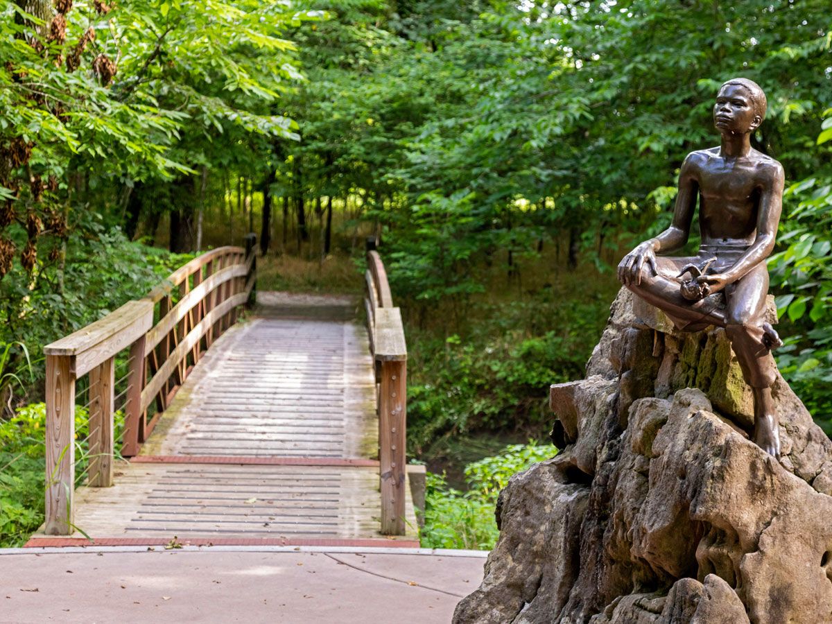
The site that honors Carver, who also served as the head of the Tuskegee Institute’s agriculture department, is located where he was born enslaved on a farm owned by Moses and Susan Carver. The park includes the mile-long Carver Trail through the woods where he first discovered his love for plants, as well as a visitors center, a commemorative bust, and a statue of him as a boy.
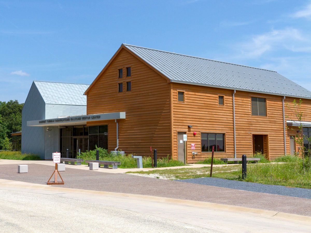
Harriet Tubman Underground Railroad National Historic Park – Church Creek, Maryland
The Harriet Tubman Byway winds through 125 miles of Maryland’s Eastern Shore and 98 miles of Delaware before ending in Philadelphia. But it’s the Harriet Tubman Underground Railroad Visitor Center in Church Creek that serves as the gateway to the 36 sites along the route. The 10,000-square-foot space features exhibits following her early years as an enslaved person in the area, as well as the secret network she developed to help guide fellow enslaved peoples to freedom.
While the area may seem to lack physical monuments, the site notes that Tubman “is memorialized in the land, water, and sky of the Eastern Shore where she was born and where she returned again and again to free others.”
Tuskegee Airmen Monument –
Charles Young Buffalo Soldiers National Monument – Wilberforce, Ohio
Despite being born into slavery and facing injustice as a Black American in the military, Charles Young rose through the ranks to become a U.S. Army distinguished officer and the first Black West Point graduate to reach the rank of colonel. He later became the first Black national park superintendent.
So it’s fitting that the Ohio National Monument honors his legacy, as well as those of the Buffalo Soldiers — the name given to the African American regiments that formed in 1866 and served for five decades. The monument is located in Wilberforce, where Young taught military sciences and tactics at Wilberforce University; the city is also home to the National Afro-African Museum and Cultural Center.
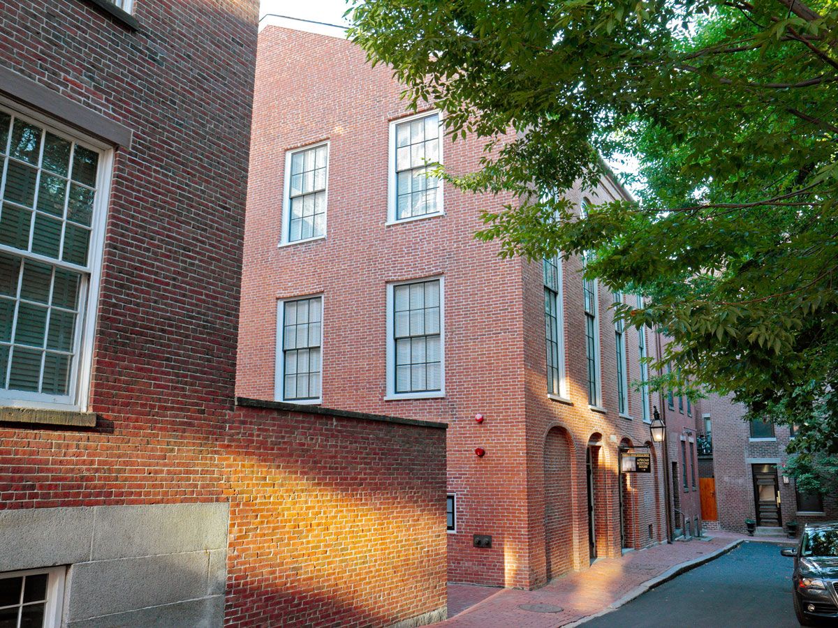
Built in 1806, the African Meeting House on Beacon Hill now stands as the oldest existing Black church in the country, as well as the first African American Baptist Church north of the Mason-Dixon line. But it became so much more than that — also serving as the central meeting place of Boston’s Black community, and even holding classes for the African School before that.
It later became a Jewish synagogue for a period, but the building was acquired by the Museum of African History in 1972 and underwent a $9.2 million renovation to restore it to its 1855 appearance.
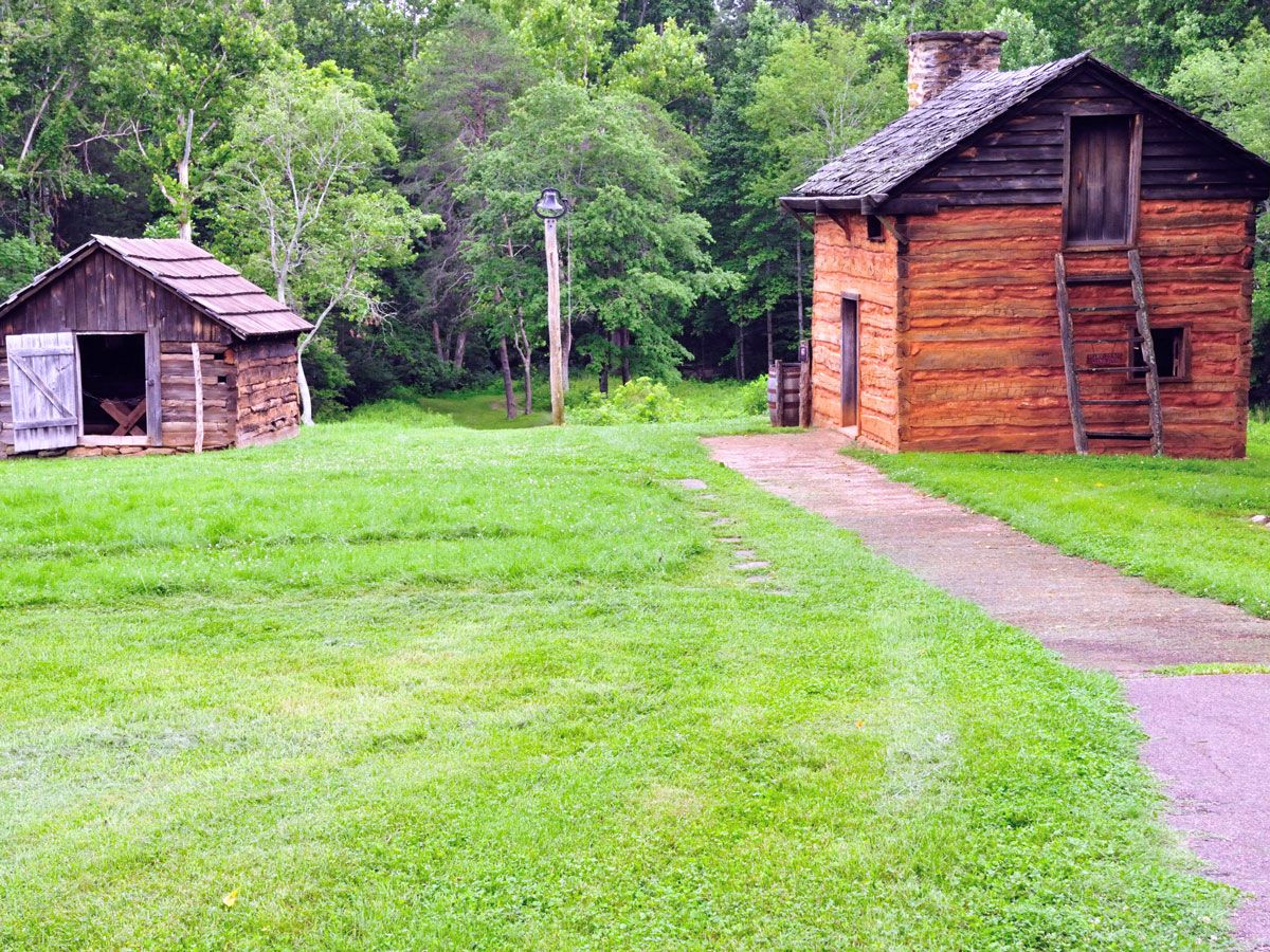
Booker T. Washington National Monument – Hardy, Virginia
Growing up as an enslaved person on a 207-acre tobacco farm owned by James and Elizabeth Burroughs, Booker T. Washington spent his early years yearning for freedom. Now the site serves as a monument to the first president of Tuskegee Normal and Industrial Institute (which later became Tuskegee University), who reformed education and became a spokesperson for Black Americans at the turn of the 20th century.
The visitor center follows Washington’s life, both in and beyond the former plantation, which also has recreations of 19th-century farm buildings, a garden representing the planting techniques used in the 1850s, and a farm area with sheep, pigs, chickens, and horses.
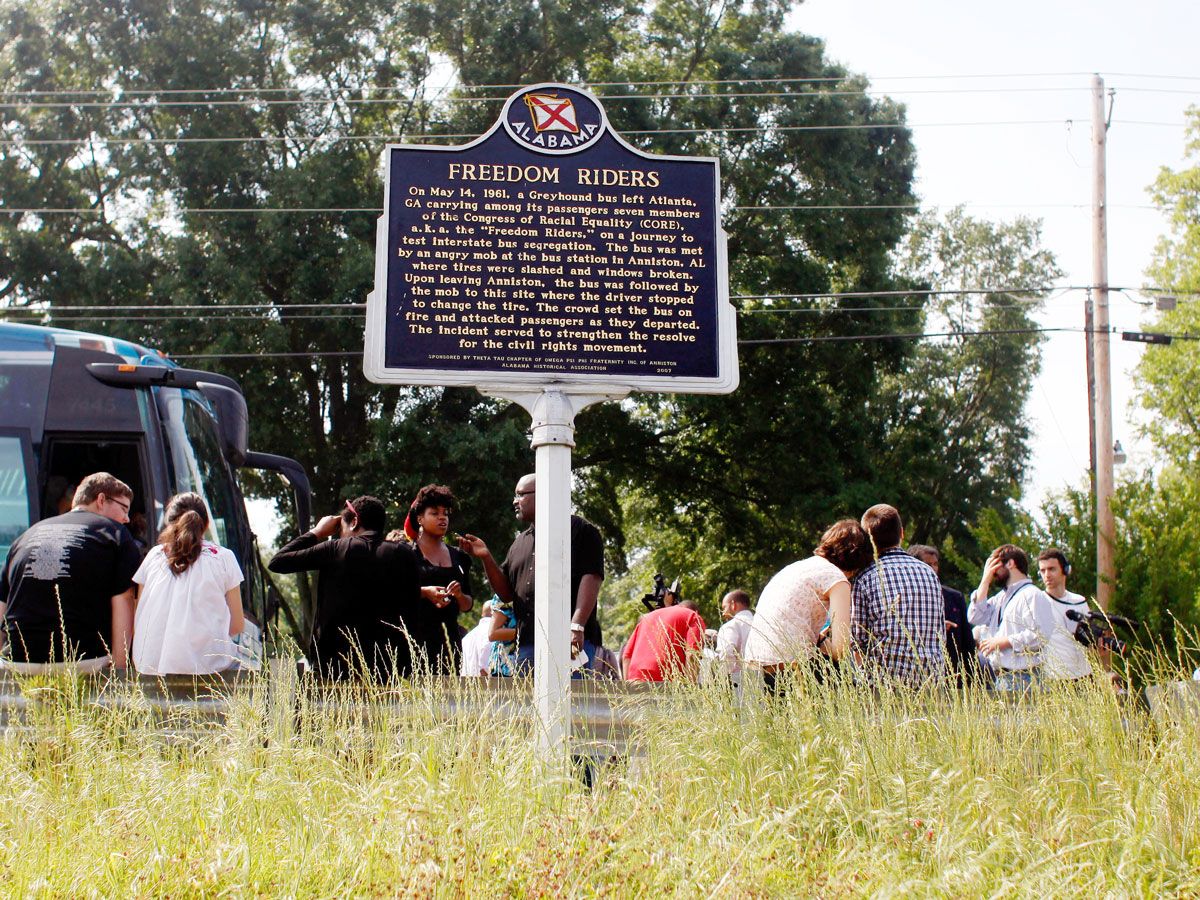
Freedom Riders National Monument – Anniston, Alabama
A group of 13 Freedom Riders — both Black and white — set out in the spring of 1961 with one mission: To end segregation on buses and at bus facilities. They were met by violent opposition from white supremacists, resulting in incidents like a firebombed bus just outside of Anniston.
The two parts of this national monument include the Greyhound Bus Station on Gurnee Avenue — where the group boarded the bus to Birmingham, but were met with rocks being hurled at them and the bus tires behind slashed — and the Bus Burning Site on Old Birmingham Highway six miles away, where the tires gave out and the mob threw a burning rag, causing the explosion.
Martin Luther King, Jr. Memorial – Washington, D.C.
Until 2011, the National Mall didn’t have a single memorial dedicated to a Black American individual. That changed when Baptist minister-turned-civil rights activist Martin Luther King, Jr. was honored with this towering 30-foot granite stone sculpture. Symbolically located at 1964 Independence Avenue, the monument honors the Civil Rights Act of 1964. It also marked the first D.C. monument not dedicated to a President or a war.
Prominently located at the Tidal Basin opposite from the Jefferson Memorial, the landmark is packed with symbolism, stemming from King’s famous quote, “Out of the mountain of despair, a stone of hope.” Upon arrival, visitors first pass through two halves of the Mountain of Despair before reaching the Stone of Hope, where King’s statue is located.
Advertisement
More from our network
Daily Passport is part of Inbox Studio, an email-first media company. *Indicates a third-party property.
These Are the Only 5 Countries That Don’t Have Airports
By
Daily Passport Team
Read time: 3 minutes
January 11, 2024
Updated: May 8, 2026
These Are the Only 5 Countries That Don’t Have Airports
Culture •January 11, 2024•Updated: May 8, 2026
By Daily Passport Team
Author
Daily Passport Team
Daily Passport writers have been seen in publications such as National Geographic, Food & Wine, CBC, Condé Nast Traveler, and Business Insider. They're passionate about uncovering unique destinations and sharing expert tips with curious travelers.
Thanks to jet travel, our world is more interconnected than ever. We can book a ticket and board a flight to anywhere we want to go — almost. You might be surprised to learn that there are some countries on the planet that don’t have a single airport. Whether it’s because of restrictions on space, limited resources, or a desire to keep noise out, these five nations are the world’s only countries that don’t have airports.
A landlocked nation located high in the Pyrenees Mountains between France and Spain, Andorra is one of the world’s smallest countries — covering just 180 square miles. The country is home to around 85,000 people, who speak the Romance language of Catalan as the sole official language. Due to its mountainous location, its capital, Andorra la Vella, is the highest capital city in Europe at 3,356 feet above sea level. The closest airports are in Barcelona, Spain, and Toulouse, France, both about three hours away. Even though Andorra does not have airports, it does have three helicopter landing pads located in La Massana, Arinsal, and Escaldes-Engordany.
Liechtenstein is another tiny, mountainous European nation. Sandwiched between Austria and Switzerland, it is not only the world’s sixth-smallest country (covering just 62 square miles) but also only one of two countries on Earth that are doubly landlocked, along with Uzbekistan. It is also the only country in Europe that is entirely located within the Alps. Given its small size and proximity to other nations, Liechtenstein doesn’t have any airports. The distance to the closest airport in Zurich, Switzerland, is approximately 80 miles. Unlike Andorra, Liechtenstein has only one helicopter pad, which is located in Balzers.
Entirely surrounded by the city of Rome, Vatican City is the world’s smallest country. The city-state — the global headquarters of the Roman Catholic Church and residence of the Pope — is home to just 800 people and covers 0.2 square miles. It’s no surprise, then, that the Vatican doesn’t have any airport — the city-state doesn’t even have highways. The only way for visitors to reach Vatican City is through Italy’s capital, Rome. The closest airport is the Rome-Ciampino Airport, which is only nine miles away.
Along with Vatican City and Lesotho, San Marino is one of the world’s only three enclave countries. Established in 301 CE, it is the world’s oldest-surviving constitutional republic. San Marino is located in the Apennine Mountains in the northeastern region of Italy and covers just 24 square miles, with a population of just over 30,000. San Marino is also close to the Federico Fellini International Airport in Rimini, Italy, which is located about 70 miles away.
The fifth and final country without an airport is the glamorous country of Monaco in the French Riviera. Nicknamed the “Billionaire’s Playground” for its high concentration of wealth, this coastal country is nestled between the Mediterranean Sea and France and covers just 0.78 square miles. It has the world’s shortest coastline. With a population of just under 40,000 people, Monaco is one of the most densely populated places on Earth — and there’s no room for an airport. Fortunately, Cote d’Azur Airport in Nice, France, is only about 30 minutes away by car. Monaco also has a heliport at Fontvieille that accommodates wealthy visitors and dignitaries.
Advertisement
More from our network
Daily Passport is part of Inbox Studio, an email-first media company. *Indicates a third-party property.
Daily Passport writers have been seen in publications such as National Geographic, Food & Wine, CBC, Condé Nast Traveler, and Business Insider. They're passionate about uncovering unique destinations and sharing expert tips with curious travelers.
Over half of the world’s animal and plant species call rainforests home. These incredibly diverse ecosystems are found on every continent except Antarctica and play an essential role in absorbing Earth’s greenhouse gasses — earning them the nickname the “lungs of the planet.” Dive into the fascinating flora and fauna of eight of the world’s most biodiverse rainforests.
At 180 million years old, the Daintree Rainforest in northeastern Australia is the world’s oldest tropical rainforest. If you visit, you might like you’ve landed on a film set, where you’ll be surrounded by beautiful jungle and plunging 400-foot-tall waterfalls. That’s no coincidence: The rainforest reportedly inspired director James Cameron when creating the 2009 sci-fi movie Avatar. Rare and endemic animals to watch for include southern cassowary birds, Bennett’s and Lumholtz’s tree kangaroos, lesser sooty owls, and Australia’s largest native carnivore, the spotted-tail quoll.
Daintree is part of the Wet Tropics of Queensland, officially recognized as a UNESCO World Heritage Site since 1988. It also happens to be one of the only places on Earth where two World Heritage Sites meet — Daintree’s deserted, breathtaking beaches border the Great Barrier Reef. Visitors will find plenty to do and see — from taking river cruises along the scenic Daintree River (where saltwater crocodiles linger) and eco walks along aerial walkways and viewing platforms to horseback riding and zipping across the forest canopy on the Skyway Rainforest Cableway. Like most of the world’s rainforests, Daintree also suffers from deforestation, mostly due to livestock pastures.
Covering roughly 2.1 million square miles across Brazil, Peru, Colombia, Bolivia, Ecuador, Venezuela, French Guiana, Suriname, and Guyana, the Amazon Rainforest is the world’s best-known and largest rainforest. The mighty Amazon River that flows through the rainforest is the world’s largest river by volume, while the surrounding forest is buzzing with animals, insects, and plants.
The Amazon is home to more species than any other terrestrial ecosystem on Earth — 10 to 30% of the world’s species by some estimates. Hiding in the canopy are numerous primates, slow-moving sloths, and brightly colored macaws. Jaguars, pumas, anacondas, and giant anteaters hunt for prey along the forest floor. Alarmingly, the Amazon Rainforest decreases in size daily due to massive deforestation. Farming, livestock grazing, illegal logging, mining, and more recently, devastating human-caused fires have caused accelerated losses. If you’re interested in supporting efforts to save the Amazon, check out these suggestions on how to help.
This approximately 26,560-square-mile temperate rainforest is the United States’ largest forest, covering most of southeastern Alaska. Together, the Tongass National Forest and British Columbia’s Great Bear Rainforest form Earth’s largest temperate rainforest. Temperate rainforests differ from tropical rainforests in that they receive less precipitation, see cooler temperatures, and have a slower decomposition of dead organic matter, creating nutrient-rich soil.
The region covers an island archipelago surrounding the dramatically impressive Inside Passage, so be prepared for breathtaking views and wildlife such as bears, eagles, orcas, wolves, beavers, and spawning salmon. Towering stands of ancient western hemlock and Sitka spruce trees dominate the canopy layer, soaring 100 to 225 feet tall, respectively. The USDA Forest Service operates three visitor centers and multiple viewing areas, making it easy for visitors to enjoy the region’s splendor.
Threats to the Tongass include industrial clearcut logging. In 2001, the Forest Service established the Roadless Area Conservation Rule to protect 60 million acres of national forest (including the Tongass) from this type of logging that leaves swaths of devastation behind. However, in 2020 nine million acres of Tongass land were removed from the rule’s protection, leading conservationists and many other groups to protest. Learn more about how you can help with the Alaska Wilderness League.
Kinabalu Park became Malaysia’s first UNESCO World Heritage Site, earning a designation in 2000 for its role as one of the world’s most important biological sites. Located on the island of Borneo’s northern tip, this 130-million-year-old rainforest is home to over 5,000 species of flora and fauna and features four climate zones. Mount Kinabalu soars 13,435 feet over the 291-square-mile jungle.
Kinabalu Park is one of the few places in the world to see the rafflesia, a flowering plant infamous for smelling like a dead corpse during the three to four days it blooms after a six-to-nine month growing season. Another of the park’s unique inhabitants is the giant Malaysian pitcher plant, which eats insects and even small birds, lizards, rats, and frogs.
Many visitors know about Costa Rica’s Monteverde Cloud Forest Biological Preserve, but a visit to the nearby and less-crowded Santa Elena Cloud Forest Reserve is well worth a trip. A cloud forest earns its name due to the persistent, canopy-level cloud cover, which is more of a mist created from the high elevation and humidity. Stroll along the trails and hanging bridges where you’ll spot countless birds, including the elusive green and red resplendent quetzal. The reserve has structures encouraging quetzals to nest in a protected area (easily visible from a hiking trail).
Spider monkeys, sloths, pumas, jaguars, and jaguarundi are among some of the mammals that live here. To see the most animals and unique plants, take a private guided tour early in the morning. The reserve also contains observation platforms and towers with spectacular views of the Arenal, Rincón de la Vieja, Tenorio, and Miravalles Volcanoes.
The world’s second-largest tropical rainforest, covering 387,261 square miles lies in Central Africa, spans the Democratic Republic of Congo, Cameroon, Republic of Congo, Central African Republic, Equatorial Guinea, and Gabon. About 30% of the roughly 10,000 plant species are endemic, and large, endangered animals such as chimpanzees, forest elephants, gorillas, buffalos, and bonobos live here. The world’s second-largest river by volume, the Congo River, flows through the rainforest. Trees in the Congo Rainforest tend to grow taller and slightly less dense than other tropical rainforests because elephants, gorillas, and other large herbivores eat smaller trees, reducing competition for resources.
Until about 10 years ago, the Congo Rainforest’s deforestation rates were among the world’s lowest. However, industrial logging has led to significantly faster deforestation, and easier access from logging roads has created a poaching epidemic of forest elephants in some areas. The World Wildlife Fund is one of many groups working to preserve this vital resource by working with indigenous peoples and local communities who rely on its water, food, shelter, and medicine.
Most people probably don’t think of Europe when they hear the word “rainforest,” but head to southeastern Bosnia and Herzegovina and you’ll be pleasantly surprised to find Perućica in Sutjeska National Park. This unspoiled, 20,000-year-old forest is one of Europe’s last remaining primeval rainforests (and is awaiting approval to become an official UNESCO World Heritage Site). Perućica occupies about 3,500 acres of the 43,000-acre Sutjeska National Park, with sections so dense they’ve never been fully explored. Protected from commercial logging, some of the rainforest’s 200-foot-tall beech and endemic black pine trees are 300 years old.
One of Perućica’s notable residents is the Balkan chamois, a goat-antelope species native to European mountain ranges. Bears, wolves, foxes, lynxes, wild cats, mink martens, wild boars, badgers, and wild goats also roam this incredibly preserved forest. Hiding within the rugged mountains and sweeping valleys is the stunning 246-foot-tall Skakavac Waterfall, but visitors will find it’s well worth the hike.
If you want to visit a rainforest so lush and green it almost seems surreal, look no further than the Hoh Rainforest on Washington’s Olympic Peninsula. Situated within Olympic National Park, the Hoh is the wettest forest in the contiguous United States, receiving more than 150 inches of rain annually. Prevalent mist and fog add the equivalent of 30 more inches, making the Hoh also one of the world’s lushest rainforests. Endless acres of soaring trees draped in moss and hanging ferns create an ethereal, timeless landscape, so much so that the Hoh earned a spot on the UNESCO World Heritage Site list. Start at the Hoh Rainforest Visitor Center, where you can find maps for self-guided trails or join guided walks during the summer.
Advertisement
More from our network
Daily Passport is part of Inbox Studio, an email-first media company. *Indicates a third-party property.
Midwest or Northeast — How Are the U.S. Geographical Regions Defined?
By
Bennett Kleinman
Read time: 5 minutes
January 10, 2024
Updated: January 24, 2024
Midwest or Northeast — How Are the U.S. Geographical Regions Defined?
Geography •January 10, 2024•Updated: January 24, 2024
By Bennett Kleinman
Author
Bennett Kleinman
Bennett is a New York City-based staff writer for Daily Passport. He previously contributed to television programs such as the Late Show With David Letterman, as well as digital publications like the Onion. Bennett has traveled to 48 U.S. states and all 30 Major League Baseball stadiums.
Have you ever wondered if a state like Kansas is considered part of the Midwest or the West? Fortunately, there’s an answer for that. The United States Census Bureau divides the country into four distinct geographical regions: the Midwest, the Northeast, the South, and the West. Those are further divided up into more specific areas, such as New England and the South Atlantic. All of these regions have vast geological, cultural, and population differences. Here’s how each different region of the U.S. is officially defined, according to the census.
Twelve states are part of the Midwest region, found in the northern center of the United States. The region is broken down further into the East North Central region (which includes Illinois, Indiana, Michigan, Ohio, and Wisconsin) and West North Central region (Iowa, Kansas, Minnesota, Missouri, Nebraska, North Dakota, and South Dakota).
There are nearly 70 million people living throughout the Midwest. Illinois is the Midwest’s most populous state with around 12.5 million residents, while North Dakota is the least populous at around 780,000 people.
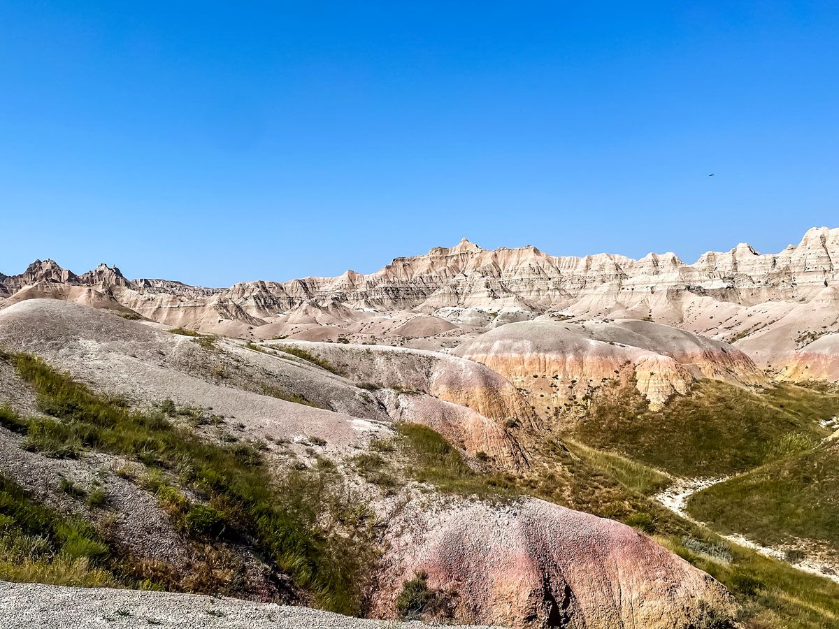
Six of the Midwest states border the Great Lakes, a defining natural feature of the region. Michigan alone borders Lakes Erie, Huron, Michigan, and Superior. The Midwest is also home to eight national parks, including Missouri’s Gateway Arch National Park (the country’s smallest national park) and South Dakota’s Badlands National Park. South Dakota is also where you can find Mount Rushmore, as well as America’s geographic center, located in the town of Belle Fourche. The Midwest also has a strong connection with American political history, as there are 11 presidential birthplaces located throughout the region, including seven in Ohio alone.
The Northeast, nestled between Canada and the Atlantic Ocean, contains nine states. The region is further divided into two sections: New England (consisting of Connecticut, Maine, Massachusetts, New Hampshire, Rhode Island, and Vermont) and the Middle Atlantic (New Jersey, New York, and Pennsylvania). Seven of these states border the Atlantic Ocean; Pennsylvania and Vermont are the sole exceptions.
The Northeast is home to approximately 57 million residents, which makes it the least populous of the four Census-defined regions. The most populated state in the Northeast is New York, home to roughly 19.5 million people and the country’s largest city, New York City. Interestingly, the Middle Atlantic (with 41 million residents) has more than double the total population of New England (about 16 million residents).
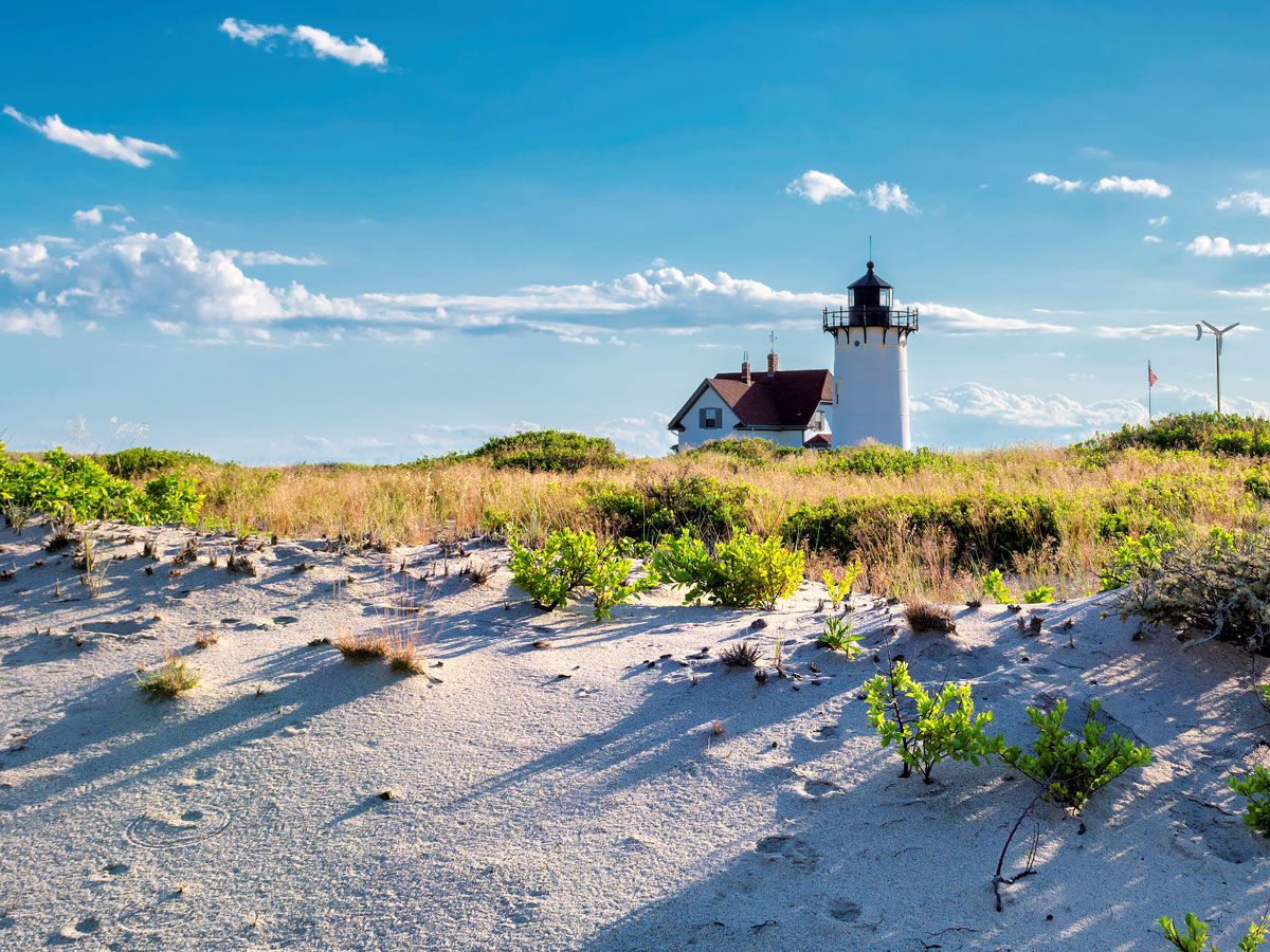
There’s only a single national park located in the Northeast — Maine’s Acadia National Park — but the region has plenty of other incredible natural landmarks. These include Niagara Falls in northern New York, as well as the beach haven of Cape Cod, which extends out into the Atlantic from Massachusetts. There are plenty of historic human-made landmarks, as well, including some of the oldest buildings in the country. Rhode Island is also home to the White Horse Tavern, which is America’s oldest continuously operating restaurant, open since 1673.
The South encompasses 16 states, plus Washington, D.C. That includes all of the states bordering below New Jersey and the Mason-Dixon Line, as well as the states that share a border with the Gulf of Mexico. The region is divided into three segments: the South Atlantic region (Delaware, Florida, Georgia, Maryland, North Carolina, South Carolina, Virginia, West Virginia, and also Washington, D.C.), the East South Central region (Alabama, Kentucky, Mississippi, and Tennessee), and finally the West South Central region (Arkansas, Louisiana, Oklahoma, and Texas).
There are roughly 130 million Americans living throughout the South, making it the most heavily populated geographic region in the U.S. Of all the Southern states, Texas leads the pack with 30.5 million people, while Delaware — the country’s first state — brings up the rear with just over a million residents.
There are 11 national parks found throughout the South, including Mammoth Cave in Kentucky, home to the world’s longest known cave system with over 400 miles explored. There are also parks with tremendous ecological importance, such as the Florida Everglades, which is the only place in the world where alligators and crocodiles coexist. For history buffs, there are many important Civil War-era battlefields located throughout the South — including Antietam in Maryland, Harper’s Ferry in West Virginia, and Vicksburg in Mississippi. The South is also a political heavy hitter: Virginia has produced the most Presidents of any state, with eight.
The fourth and final region of the United States is the West, which is the largest by total area at approximately 1.74 million square miles — accounting for roughly half of the entire country. The American West is broken down into the Mountain zone (Arizona, Colorado, Idaho, Montana, Nevada, New Mexico, Utah, and Wyoming) and the Pacific (Alaska, California, Hawaii, Oregon, and Washington).
The region contains the country’s largest state by area (Alaska and its 586,000 square miles), the country’s most populous state (California and its 39 million residents), and its least populous state (Wyoming, with 583,000 residents). All told, there are around 78 million people who call the West home.
The West contains 41 of the country’s 63 national parks, far more than any other region. A record nine of those are located in California — including sites like Yosemite and Redwood — while there are eight in Alaska, including America’s largest national park, Wrangell St. Elias (13.2 million acres). Yellowstone National Park sits atop an underground supervolcano known as the Yellowstone Caldera. This 1,350-square-mile caldera is unlike any other geological feature known throughout the country, and last erupted around 640,000 years ago. Other unique aspects of Western geography include the towering hoodoo rock formations in Utah’s Bryce Canyon, as well as the country’s deepest lake — Oregon’s Crater Lake, which descends to a depth of 1,943 feet.
Advertisement
More from our network
Daily Passport is part of Inbox Studio, an email-first media company. *Indicates a third-party property.
The 10 Fastest-Growing Tourism Destinations in 2024
By
Bennett Kleinman
Read time: 7 minutes
January 8, 2024
Updated: January 24, 2024
The 10 Fastest-Growing Tourism Destinations in 2024
Culture •January 8, 2024•Updated: January 24, 2024
By Bennett Kleinman
Author
Bennett Kleinman
Bennett is a New York City-based staff writer for Daily Passport. He previously contributed to television programs such as the Late Show With David Letterman, as well as digital publications like the Onion. Bennett has traveled to 48 U.S. states and all 30 Major League Baseball stadiums.
It probably comes as no surprise that countries such as France, Spain, and the United States have historically topped the list when it comes to annual tourism numbers. But there are plenty of lesser-known nations around the world that are growing more attractive to visitors with each passing year. From island paradises to former Yugoslav territories, these burgeoning travel destinations are on the rise at a rapid pace — and they’re only going to get more popular. Here are 10 countries that are poised to see significant increases in tourism in 2024.
North Macedonia is a relatively new country, having only achieved independence after the breakup of Yugoslavia in 1991. Since then, this once off-the-radar Balkan state has blossomed into one of Europe’s most increasingly attractive tourist destinations. The numbers back it up: Online search volume for trips to North Macedonia grew by 2,835% between 2021 and 2023, while overnight visits increased by 29.3% from September 2022 to September 2023.
There are a multitude of reasons to visit North Macedonia, but perhaps none more compelling than the city of Ohrid. This former Greek colony dates to the second century BCE and once contained a staggering 365 churches within the city limits. While many of those structures have come and gone, several stunning historic sites remain, including the Church of St. John at Kaneo. This church sits atop steep cliffs with awe-inspiring views of the crystal-clear waters of Lake Ohrid below.
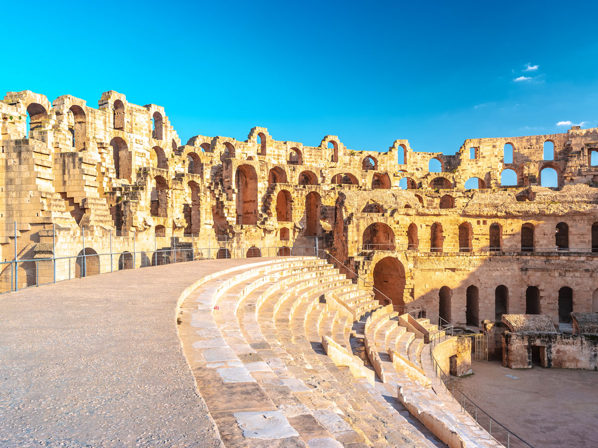
Fun fact: Tunisia isn’t just located in North Africa — the country actually contains the northernmost point on the continent. Tourism in Tunisia has skyrocketed since 2011, when the country’s autocratic government was replaced during the pro-democracy Jasmine Revolution. Post-pandemic, Tunisia’s tourism has only grown further: Total visitors have increased from 6.4 million in 2022 to an estimated 8.5 million people in 2023.
While in Tunisia, it’s well worth visiting the aforementioned northernmost point in Africa — Ras ben Sakka. Located on the shores of Cape Angela, this picturesque site features a monument that denotes its unique geographical location. Tunisia is also home to nine UNESCO World Heritage Sites, including the Amphitheatre of El Jem. This Roman ruin is the largest remaining colosseum in North Africa; at one time, it could hold as many as 35,000 spectators.
Vanuatu achieved independence in 1980, though the archipelago of 83 islands in the South Pacific Ocean was inhabited by the Melanesian peoples for centuries before then. This beachy paradise has seen a staggering 65% increase in tourism since 2019, including a 42% jump between 2022 and 2023 alone. Part of the reason for these increased tourist numbers are the growing number of flights to Vanuatu, with nonstop service now available to destinations such as Auckland, Brisbane, and Melbourne.
With pristine beaches and vibrant coral reefs, Vanuatu remains a relatively undeveloped destination. Some of the most notable natural sites include active volcanoes such as Mount Yasur and waterfalls such as the Mele Cascades. In 2003, Vanuatu opened the world’s first underwater post office, where travelers can leave letters that are picked up by scuba diving postal workers.
The Kingdom of Bhutan maintains strict tourism rules in an effort to preserve its cultural heritage. This includes a conservative dress code, rigid visa regulation, and a daily fee of $200 USD (temporarily cut to $100 per day through 2027) to offset carbon generated by visitors. Surprisingly, those regulations haven’t deterred many visitors — since first opening to tourists in 1974 and initially receiving just 300 visitors, this remote Himalayan escape now attracts hundreds of thousands of adventurers annually, a number that keeps rising.
Bhutan is home to one of the most strenuous hiking trails in the world: the Snowman Trek. Only 500 hikers have completed this difficult excursion, less than the total number of people who have summited Mount Everest. Those willing to take on the challenge should know that it takes up to a month to complete the 216-mile-long journey, with altitudes ranging anywhere between 14,000 and 18,000 feet above sea level.
Forming the connection between Central and South America, Colombia is another burgeoning tourist destination. More than 1.4 million tourists entered the country in the first quarter of 2023, a 49% increase over the previous year. That forecast is expected to only grow — with an 84.6% expected increase in revenue by the time that tourist levels hit their estimated peak in 2028.
While Colombia boasts plenty of appeal, from the high-altitude capital of Bogotá to the Caribbean beaches and historic walled city of Cartagena, a lesser-known secret is San Andrés. This remote island — located closer to Nicaragua than the Colombian mainland — is heralded for its fantastic snorkeling and beaches, which are best experienced between December and April during the dry season. While visiting San Andrés may cost more than traveling to mainland Colombia, it can be worth it to escape the crowds.
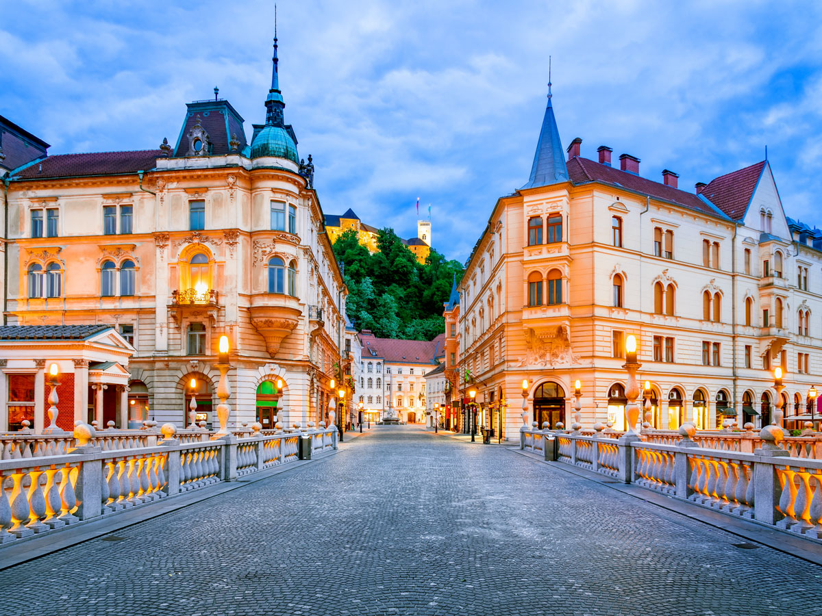
You might not be able to point out Slovenia on a map, but booking a flight there is still plenty easy. This tiny nation bordering Italy, Austria, Hungary, and Croatia has a small coastline along the northern Adriatic Sea and is considered by many to be one of the most scenic countries in all of Europe. The country saw a 38.5% increase in tourism between 2021 to 2022, and an additional 18.7% the following year. And as more people learn about this European gem, those numbers are expected to rise.
Slovenia is a wine lover’s paradise, with an estimated 28,400 wineries — that’s one vineyard for every 70 Slovenians. The capital of Ljubljana is a particularly attractive city break because there are restrictions on car traffic in the city center of Ljubljana, making it a perfect place to walk and bike the historic cobblestone streets.
Search volume for vacations to Senegal grew 535% between 2021 and 2023, as more and more people consider visiting this West African nation. Prior to the pandemic, tourism made up just 9% of Senegal’s total GDP. But in 2016, tourism officials set a goal of welcoming 1.5 million visitors that year, and they are expected to double the number to 3 million tourists by 2023.
Senegal is home to the westernmost point in continental Africa: Pointe des Almadies. There are also seven Senegalese World Heritage Sites that are worth seeing, including Saint-Louis. This former capital of French West Africa contains some of the most striking French colonial architecture in Senegal, with many colorful houses lining the Senegal River. Saint-Louis also hosts a celebrated jazz festival between April and May each year.
Albania, which borders North Macedonia to the west, saw its online search trends increase by 1,272% over the last three years, as tourism continues to skyrocket. Albania has become a particularly attractive spot for Italian tourists, with a 50% increase on visits from Italian nationals alone. All told, the country has seen a 25% increase in recent visits year over year.
Albania’s capital city of Tirana is a particularly stunning destination, and what better way to start your visit than with a cable car ride up to the top of scenic Mount Dajti? It’s also worth checking out Bunk Art, a former military base that’s since been converted into an art museum. Lastly, consider visiting the town of Durrës, which has been inhabited since the seventh century BCE and offers a mix of glistening beaches and fascinating ancient archeological sites.
While many people visit nearby India, considerably fewer tourists travel to this teardrop-shaped nation just off India’s southeastern coast. That may be changing. In recent years, Sri Lanka’s tourism numbers surpassed 110,000 annual visitors. Foreign tourist arrivals increased a whopping 159.8% between October 2022 and October 2023.
Any visitor to Sri Lanka should try the locally grown Ceylon cinnamon on Ganduwa Island, which is prized worldwide for its light and sweetest flavor profile. Sri Lanka is also known for its diverse ecology — for example, in Bundala National Park, more than 200 species of birds thrive. It’s also worth taking a day trip to Sigiriya, a towering 590-foot rock formation featuring ancient fortifications from the fifth century built on top.
The Dominican Republic is certainly no longer a secret, but this Caribbean paradise on the island of Hispaniola continues to shatter tourism records. More than 600,000 people visited in the month of October 2023 alone, thanks to its easy accessibility from dozens of cities in North America. It’s estimated that the Dominican Republic will welcome upwards of 10 million visitors throughout 2023, with even more to come in 2024.
Given its location in the heart of the Caribbean, it should come as no surprise that the Dominican Republic is known for its stunning beaches. But the country also has a rich history, especially at the Colonial City of Santo Domingo. This capital and UNESCO World Heritage Site was founded back in 1498, and pioneered the grid city layout that many other cities have since adopted. There are also several 16th-century churches and fortresses you can visit in Santo Domingo.
Advertisement
More from our network
Daily Passport is part of Inbox Studio, an email-first media company. *Indicates a third-party property.
7 Impressive Examples of Roman Architecture (Outside of Italy)
By
Julia Hammond
Read time: 6 minutes
January 8, 2024
Updated: January 24, 2024
7 Impressive Examples of Roman Architecture (Outside of Italy)
Architecture •January 8, 2024•Updated: January 24, 2024
By Julia Hammond
Author
Julia Hammond
Julia is a U.K.-based travel writer whose work has been featured in The Independent, The Telegraph, The New Zealand Herald, and Culture Trip, among others. She’s an enthusiastic advocate for independent travel and a passionate geographer who has had the privilege of traveling to more than 130 countries in search of a story.
At its peak in 117 CE, the Roman Empire had spread far beyond what is now Italy. Its reach extended over 2 million square miles, from northern Britain, around the entire Mediterranean Sea, and into southern Egypt. Fast forward to the 21st century, and many of the buildings and structures that the Romans erected have remarkably survived, though some are little more than ruins. If you’re interested in seeing them for yourself, here are seven stellar examples of ancient Roman architecture located outside of Italy.
The longest surviving fortification from the Roman Empire, Hadrian’s Wall stretches across northern England, from Bowness-on-Solway in Cumbria to Wallsend on the River Tyne. In 122 CE, during a visit to the province of Britannia on the northern edge of the Roman Empire, Emperor Hadrian ordered his army to build a wall to keep the Barbarians out. The 73-mile-long fortification took about six years to complete. Its design incorporated a string of forts and milecastles, which enabled the soldiers to fend off any attempted incursions.
When Emperor Hadrian died, his successor Antoninus Pius decided to build the Antonine Wall in 142 CE about 20 miles north of Hadrian’s Wall. But this replacement used turf rather than stone and proved less effective, so it was abandoned in favor of Hadrian’s Wall. Over the centuries, the structure was plundered for its stone, but since the 19th century it has been protected and preserved, and is now part of a UNESCO World Heritage Site.
Located in the Occitanie region of southern France, the Pont du Gard is the world’s tallest Roman aqueduct bridge standing today. The historic aqueduct once supplied the city of Nîmes, then the Roman colony of Nemausus, with its water in the first century CE. Built from limestone, it stands around 160 feet tall and would typically have carried about 11 million gallons of water each day. The Pont du Gard took a team of around a thousand builders five years to construct.
After the fall of the Roman Empire, it was repurposed as an early example of a toll bridge. Now, almost 2,000 years later, an immersive museum explains how it was constructed and why it was so impressive. Guided tours run several days a week, enabling visitors to step inside the third tier of the structure.
Construction on the Roman amphitheater at El Djem (sometimes spelled El Jem) began in 238 CE. It was a tumultuous time in what was then Thysdrus (now a town in northeastern Tunisia). That year, the local population staged a spirited, yet ultimately unsuccessful revolt. Nevertheless, this spectacular landmark — boasting three still-accessible tiers of arcades, as well as a labyrinth of underground rooms and passages — is a testament to the effort the Romans made in providing arenas for spectator events.
When it was finished, the amphitheater accommodated a crowd of approximately 35,000 people. Historians believe that this makes it the third-largest surviving amphitheater, after the Colosseum in Rome and that of Capua, home to the empire’s first gladiator school. Given that the structure has no foundations and is freestanding, it’s particularly noteworthy that it still stands.
The Porta Nigra is a remarkably intact Roman gate that stands in the heart of Trier, which is the oldest city in Germany. Construction began in 170 CE, and originally it was one of a quartet of gates. There’s no record of what the Romans themselves called it, but it has been known as the Porta Nigra for at least 900 years. The name of the sandstone structure is Latin for “Black Gate,” most likely a nod to the dirt it acquired during its lifetime.
For a period, the Porta Nigra was rebuilt and used as a burial place in the 11th century and later converted into a church, but it was returned to its original state on Napoleon’s orders in the early 19th century. Visitors today can admire the gate’s intricate stonework and the iron clamps that held it together.
The Cardo Maximus was the main north-south street found in many ancient Roman cities and military forts. The one in Jerash — formerly the settlement of Gerasa and considered one of the best-preserved examples of a Roman provincial town — stretches about half a mile between the city’s North Gate and Oval Plaza.
This Roman road is an impressive feat of engineering in its own right. Despite being constructed in the first century CE, skilled civil engineers knew to include manholes to facilitate underground drainage, and, if the cart ruts are anything to go by, constructed their roads to cope with busy traffic. Back then, around 500 colonnades would have lined the paved street, their heights varying according to the buildings that stood behind them. Some of them remain upright today and were reconstructed in the 20th century.
When he abdicated in 305 CE, Emperor Diocletian did so in style, retiring to a house that was part luxurious villa and part Roman military camp. Today, his sprawling palace dominates the historic core of the Croatian city of Split and draws thousands of tourists every year.
The palace, built of limestone and white marble, was as secure as a fortress — the walls that face the Adriatic Sea measure up to seven feet thick and 72 feet high. The complex once boasted 16 towers (three survive) and four gates. There was ample space to house guards and servants, as well as store a large quantity of provisions. But as well as being practical it was also fittingly magnificent, with breathtaking views out over the water and a grand gallery to display works of art.
The Temple of Diana stands on a substantial stone pedestal in the city of Mérida, the capital of western Spain’s Extremadura region. Six granite Corinthian columns front this hexagonal structure, which was erected during the first century CE when Mérida was the Roman settlement of Emerita Augusta.
Today, it is little more than a skeleton of its former self, though it’s surely an eye-catching and intriguing one. Behind, visitors will see the palace of the Duke of Corbos, built in the 16th century. Surrounding the Temple of Diana on the other three sides are modern shops, offices, and houses — whose ordinariness only serves to highlight the sacred significance of the temple. It’s not the only ancient architecture to survive in Mérida, either. Take a stroll and you’ll soon come across a Roman theater, amphitheater, Trajan arch, hippodrome, and aqueduct.
Advertisement
More from our network
Daily Passport is part of Inbox Studio, an email-first media company. *Indicates a third-party property.
The 10 Most Populous U.S. States Compared to Foreign Countries
By
Bennett Kleinman
Read time: 6 minutes
January 8, 2024
Updated: January 24, 2024
The 10 Most Populous U.S. States Compared to Foreign Countries
Geography •January 8, 2024•Updated: January 24, 2024
By Bennett Kleinman
Author
Bennett Kleinman
Bennett is a New York City-based staff writer for Daily Passport. He previously contributed to television programs such as the Late Show With David Letterman, as well as digital publications like the Onion. Bennett has traveled to 48 U.S. states and all 30 Major League Baseball stadiums.
Home to over 335 million people, the United States is the world’s third-largest country by population size, and many of its individual states are home to far more residents than some entire independent nations. That begs the question: What countries come closest to the biggest states in terms of population numbers? Here are the 10 most populous states and which countries they compare most closely to. (And if you’re wondering about the largest states by land area, we’ve compared that, too.)
As America’s 10th-most populous state, Michigan is home to roughly 10 million people. The Wolverine State has a population density of approximately 178 people per square mile. Michigan’s population numbers are within striking distance of the Central Asian nation of Tajikistan. The landlocked country — bordering Kyrgyzstan, China, Afghanistan, and Uzbekistan — is home to around 10.2 million people and 188 individuals per square mile. Approximately 621,000 Michiganders reside in Detroit, which is the state’s most populous urban area. Tajikistan’s largest city is its capital, Dushanbe, which has around 779,000 residents.
Approximately 10.7 million individuals live in North Carolina, enough to make it America’s ninth-most populous state. Those numbers equate to a population density of roughly 214.7 people per square mile. The Tar Heel State’s total population most closely compares to the Scandinavian nation of Sweden, where there are 10.6 million residents. However, Sweden’s density is much more spread out, as there are only an average of 67 Swedes per square mile of land. Charlotte, where approximately 886,000 people reside, is North Carolina’s biggest city, while Raleigh is the state capital. Sweden’s capital city of Stockholm is also its largest city, with upwards of 1.5 million inhabitants.
There are just shy of 11 million people living in the state of Georgia (not to be confused with the country of the same name, where only 3.7 million people live). Georgia’s population density is around 185.6 people per square mile. In terms of total population, the state of Georgia aligns most closely with the world’s newest country, South Sudan. Located in Central Africa, South Sudan has upwards of 11.1 million people and a population density of around 47 people per square mile. The largest city in Georgia is the capital of Atlanta (with a population of 499,000), while South Sudan’s most populous city is also its capital, Juba (population: 450,000).
The Buckeye State is home to approximately 11.8 million people, with a population density of around 288.8 people per square mile. Ohio’s total population is about 35,000 people smaller than the Caribbean nation of Haiti. However, the island country’s population density is significantly higher than Ohio, with around 1,102 Haitians per square mile. The most populous city in Ohio is its capital of Columbus, with around 908,000 residents, followed by Cleveland (362,000) and Cincinnati (310,000). The most populous city in Haiti is its capital, Port-au-Prince, with an estimated population of around 987,000 people.
About 12.6 million people call Illinois home, giving the state a density of approximately 230.8 residents per square mile. That puts Illinois within striking distance of the population of the North African country of Tunisia, where there are roughly 12.5 million residents and around 208 people living within each square mile. A sizable chunk of the Illinois population — some 2.6 million people — live in the city of Chicago, while only 113,000 people reside in the capital city of Springfield. In Tunisia, the largest city is the capital, Tunis, where around 693,000 people live.
The fifth-most populous state in the Union is Pennsylvania, which is home to around 13 million residents. That gives the Keystone State a population density of 290.6 people per square mile. Pennsylvania’s total population is closest in size to the Central African nation of Burundi, which is home to about 13.3 million people at a density of 1,335 people per square mile. Pennsylvania’s most populous city by far is Philadelphia, which has 1.6 million residents, followed by runner-up Pittsburgh, where about 303,000 people live. Burundi has two capital cities: Bujumbura (the economic capital) and Gitega (the political capital). The former is the most populous city in the country, with around 332,000 residents, while Gitega is home to roughly 135,000 people.
More than 19 million people call New York home, giving the state a population density of 428.7 people per square mile. The closest country by comparison is Kazakhstan, a Central Asian nation where around 19.7 million people live. However, Kazakhstan’s population is far more distributed over the country’s vast area, with an average of only 19 people per square mile. The Empire State’s largest city is New York City, where over 8.3 million people live. New York’s capital, Albany, is home to just over 100,000 people. The most populous city in Kazakhstan is Almaty with around 2 million residents, while its capital — Astana — is home to roughly 346,000 people.
There are approximately 22.2 million Floridians living in the Sunshine State, giving it a density around 401.4 people per square mile. That population closely compares to the island nation of Sri Lanka. Located just off the coast of India, Sri Lanka is home to slightly fewer than 22 million people, with around 904 people living within each square mile. Florida’s most populous city is Jacksonville, with 971,000 residents, while the capital city of Tallahassee is home to approximately 202,000 people. Colombo, the biggest city in Sri Lanka and the country’s financial hub, is home to roughly 5.6 million residents.
There are upwards of 30 million people who reside in Texas, which makes it the second-most populous state in the country. Given its expansive land area, there are only an average of 111.6 people living in each square mile. Madagascar — the country closest in size to Texas — is home to approximately 150,000 residents more than the Lone State State, with roughly 135 people per square mile. Approximately 2.3 million people live in Houston, making it the largest city in Texas. The Malagasy capital city of Antananarivo is the largest city in Madagascar, with approximately 1.4 million residents.
California is America’s most populous state. Home to just under 39 million individuals, the Golden State has a population density of 253.7 people per square mile. California’s size is roughly on par with the entire population of America’s northern neighbor, Canada. However, Canada is the world’s second-biggest country, covering 3.9 million square miles, so you’ll only find around 11 Canucks per square mile. California contains two cities with upwards of a million residents: Los Angeles (3.8 million) and San Diego (1.4 million). The entire country of Canada is only home to three cities with upwards of a million residents: Toronto (2.6 million), Montreal (1.6 million), and Calgary (just over 1 million).
Advertisement
More from our network
Daily Passport is part of Inbox Studio, an email-first media company. *Indicates a third-party property.
Culture •January 8, 2024•Updated: December 11, 2024
By Jersey Griggs
Author
Jersey Griggs
Jersey is a travel and lifestyle writer whose work has appeared in publications such as Condé Nast Traveler, Business Insider, and Bust. When she’s not exploring her adopted home state of Maine, she’s likely planning her next big trip.
Forget popcorn and recliner seats — theaters have come a long way from their earliest days. Stemming from the Greek word theatron, meaning “viewing place,” these outdoor venues hosted thousands of people in ancient times to watch dramatic plays, listen to musical concerts, and laugh at comedy performances. Check out five of the oldest theaters in the world and the fascinating stories behind them.
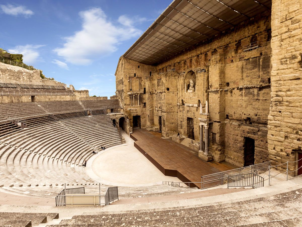
Located in France’s Rhône Valley, the Roman Theater of Orange is perhaps one of the best-preserved ancient theaters in the world. Dating back to the early first century CE, the theater was built during the reign of Emperor Augustus, a statue of whom is set in the theater’s facade. Packed with centuries of history, the theater was pillaged in the fifth century BCE, and also served as a refuge during the religious wars that occurred about a thousand years later.
Featuring seats for 10,000 spectators, the UNESCO World Heritage Site was built into the side of a hill surrounding a central orchestra pit that once housed the choir. The theater’s pièce de résistance is its 121-foot-high wall, once lauded by King Louis XIV as the “most beautiful wall in my Kingdom.” Today, the theater still hosts performances to packed crowds, with many events free to the public.
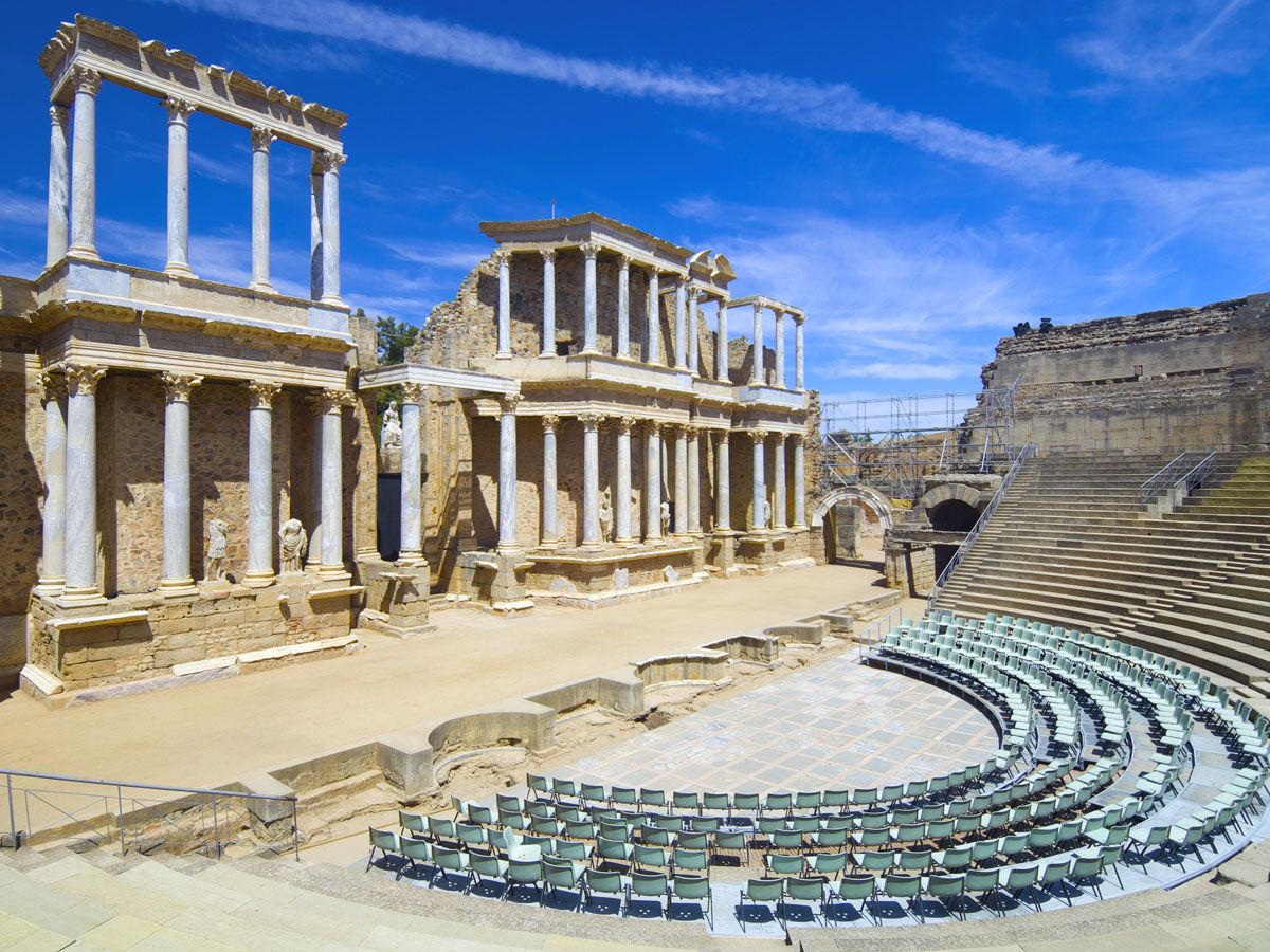
Constructed in 15 BCE, the Mérida Roman Theater was formerly located in the capital of the Roman province of Lusitania in modern-day Spain. Although the idea of theater was not popular at the time of its construction, the ruling class believed the city required a theater to match its prestige. Thus, Agrippa, the son-in-law of the Emperor, ordered one to be built. The surrounding arena holds a capacity of 6,000 spectators, while the stage is decorated with statues of gods and emperors, including the emperor’s wife, Livia, dressed as the goddess Ceres.
Today, the theater annually hosts the Festival de Mérida, Spain’s oldest classical theater festival. With its ancient walls and outdoor seating still intact, Mérida welcomes talented actors from all over to perform on one of the oldest stages in the world.
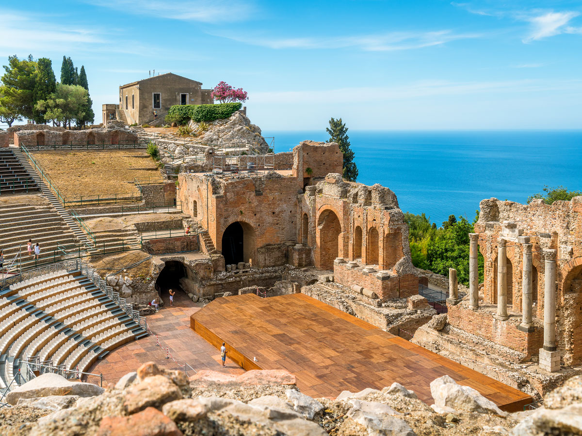
Carved into the side of Mount Tauro during the third century BCE, the Greek Theater of Taormina’s stage today is little more than ruins. Still, its spectacular location on the Sicilian coastline makes it well worth the visit, with views that stretch across the Ionian Sea. The theater once hosted ancient Greek musicals and performances and required 100,000 cubic meters of rock to be excavated from a nearby mountain to build. During the Roman occupation, several columns were added, and the theater transformed into an arena for gladiators with space for 5,400 spectators to watch dramatic scenes unfold.
Once favored by Roman politicians, Taormina continues to thrive as a popular destination for tourists. Thousands of years after it was first built, the theater — having survived earthquakes, wars, and erosion — continues to host seasonal concerts and performances.
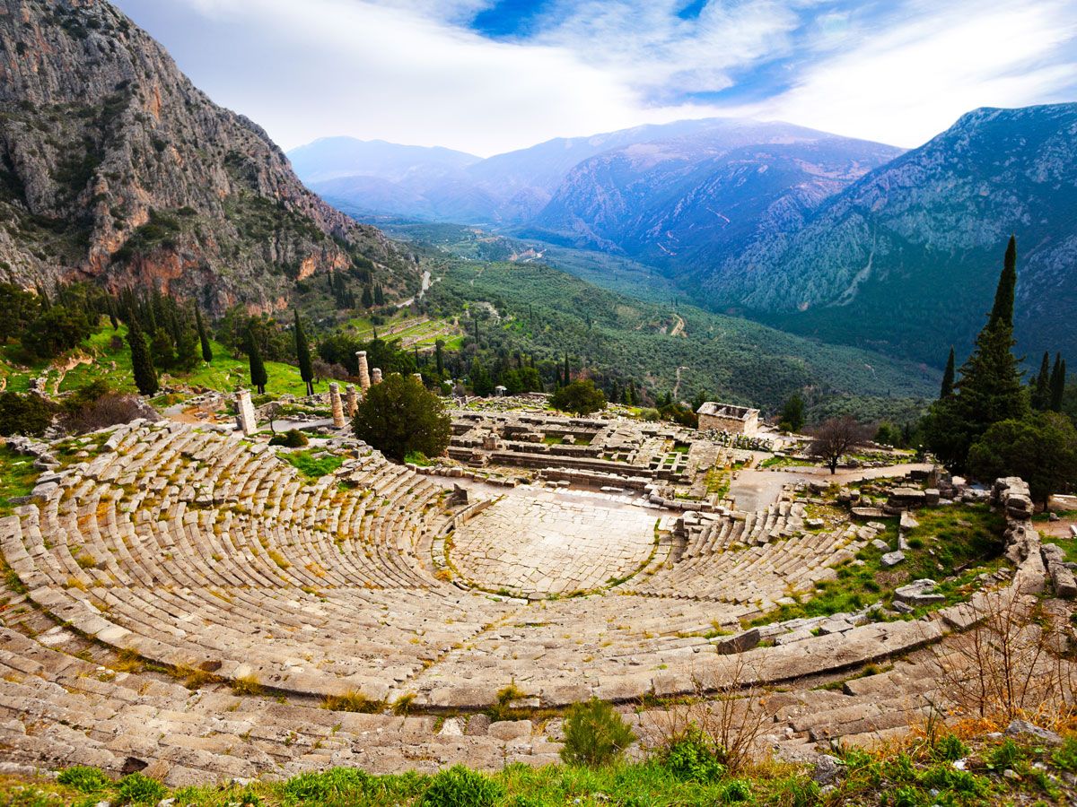
Built into the hillside near the Temple of Apollo, the Theater of Delphi was built in the fourth century BCE out of limestone excavated from Mount Parnassus. It had space to accommodate roughly 5,000 ancient spectators. With 35 descending rows, a circular stage, and space for an orchestra, Delphi was a popular site during ancient festivals, with poets, playwrights, and musicians taking to the stage to entertain the public.
The theater lasted through the Hellenistic and Roman periods and was renovated on more than one occasion — including in 159 BCE by Eumenes II, and later in 67 CE to prepare for a visit from Emperor Nero. Offering picturesque views of the mountainside and olive groves below, the ancient theater remains open to the public and often hosts plays during the summer.
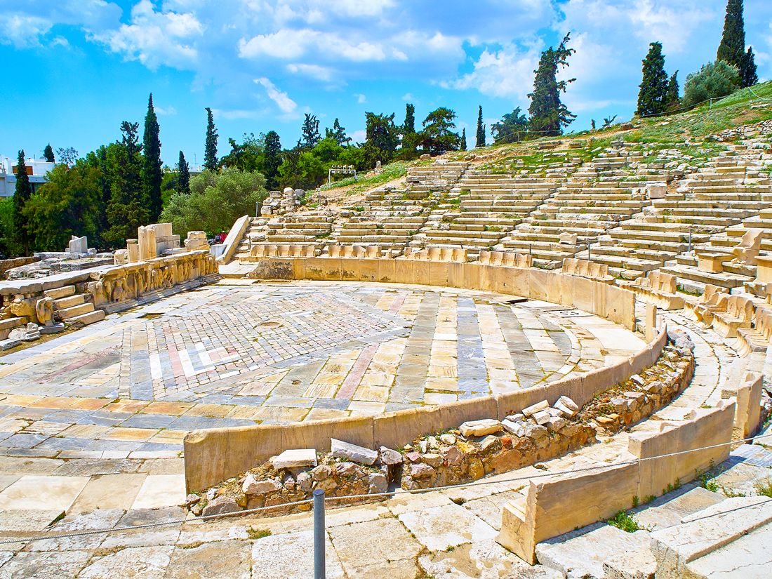
Dating back to the sixth century BCE, the Theater of Dionysus in Athens, Greece, is considered the oldest theater in the world. With construction that spanned centuries, the theater likely accommodated up to 17,000 spectators at its height during the fourth century BCE. It featured front-row seats carved into elaborate thrones reserved for the upper echelon of society.
The stage — which depicts scenes from the life of the Greek god of wine, Dionysus — was host to the works of ancient playwrights such as Sophocles, Aristophanes, and Euripides. In addition to the first plays of Athens, musicians, dancers, and mimes would often perform on stage to delighted audiences. Located on the south side of the Acropolis, this outdoor theater no longer hosts performances but remains open to visitors.
Advertisement
More from our network
Daily Passport is part of Inbox Studio, an email-first media company. *Indicates a third-party property.