Bennett is a New York City-based staff writer for Daily Passport. He previously contributed to television programs such as the Late Show With David Letterman, as well as digital publications like the Onion. Bennett has traveled to 48 U.S. states and all 30 Major League Baseball stadiums.
Everyone has a favorite beverage when flying on an airplane. Some people prefer a libation, while others would rather sip a warm cup of tea or a fizzy soda. But it may surprise you to learn there’s one beverage that experts recommend against ordering on an aircraft. Read on to find out more about the one drink you should avoid ordering on an airplane — and what to drink instead.
Should You Drink Airplane Coffee?
Credit: YakobchukOlena/ iStock via Getty Images
This caffeinated morning favorite is arguably the riskiest beverage to consume aboard an aircraft, specifically if it’s brewed aboard the plane. This has little to do with the coffee beans themselves, but rather the tap water used during the brewing process.
According to a 2019 study, many major airlines failed to meet proper cleanliness standards with regards to their onboard water tanks. Airlines are required to regularly test and disinfect these tanks to remove potentially harmful bacteria like E. coli. While airlines like Alaska and Allegiant were deemed to have relatively safe drinking water, others like JetBlue and Spirit were found to have poor cleanliness standards and could be serving up tap water that was potentially harmful to consume. This meant that any drink brewed aboard the aircraft — coffee, tea, or otherwise — was at risk of being contaminated with bacteria.
Notably, other experts have pushed back on this theory about airplane coffee being unsafe, claiming that the bacteria would be killed at the high temperatures used to brew each pot. Most bacteria die at around 175 degrees Fahrenheit, and water boils at 195 degrees when at a cruising altitude of 7,000 feet, which would be more than enough to kill the bacteria. That said, if you’re flying out of a country with unsafe drinking water or a warmer climate that could encourage bacteria growth, it’s probably worth taking extra caution to steer clear of any warm, brewed beverages.
Sanitary reasons aside, coffee is arguably a poor drink choice aboard airplanes because it can easily dehydrate you. It’s important to stay hydrated while flying, as the average humidity sits at around 20%, which makes your skin and eyes more likely to dry out than most normal atmospheric conditions. This low humidity makes diuretic beverages like coffee riskier to drink.
Sugary drinks like soda will also dehydrate you, as well as red wine, which contains byproducts that contribute to rapid dehydration. To stay hydrated, the Aerospace Medical Association recommends drinking eight ounces of water for every hour you are in the air, and preferably bottled water to avoid any potential contamination from the tanks.
What to Order Instead
Credit: Jun/ iStock via Getty Images
There’s no better drink in the sky than bottled water. It keeps you properly hydrated, and the packaging protects against any potential contaminants. But if you’re looking for a pop of added flavor, then there are several other beverages worth considering during your next plane journey.
When flying, our taste buds are affected by the high altitude and increased cabin pressure. This makes certain drinks taste different — some arguably better. One of the most popular beverages with a different flavor profile in the sky is ginger ale. When in the air, ginger ale’s sweetness is dulled, thus giving it a sharper and crisper taste. Ginger has anti-inflammatory properties that encourage circulation, which could be beneficial when sitting for hours on a long flight. Fresh ginger also helps ease nausea that may occur while traveling — just be aware that popular brands like Canada Dry and Schweppes have far too little real ginger (and too much sugar) to provide any notable anti-inflammatory benefits, but many travelers enjoy the taste.
Tomato-based beverages are another popular option in the air, as their strong flavor profile still shines even with dulled taste buds. This includes plain tomato juice or even cocktails like a bloody mary. Studies show that tomato juice tastes crisper and more refreshing in the air, providing a satisfying umami flavor. Tomatoes are also rich in antioxidants and have noted anti-inflammatory benefits, which could help promote circulation during long flights. Keep in mind that these drinks often contain high levels of sodium that could contribute to dehydration, so be sure to supplement any tomato-based drinks with bottled water.
Advertisement
More from our network
Daily Passport is part of Inbox Studio, an email-first media company. *Indicates a third-party property.
6 Incredible Natural Wonders to See Before They Disappear
By
Fiona Mokry
Read time: 5 minutes
April 3, 2024
Updated: December 11, 2024
6 Incredible Natural Wonders to See Before They Disappear
Outdoors •April 3, 2024•Updated: December 11, 2024
By Fiona Mokry
Author
Fiona Mokry
Fiona has spent her career exploring the world and working in the travel industry, turning her lifelong passion into a profession. From planning custom trips to sharing stories as a travel writer for publications such as The Discoverer, she’s all about helping others experience the world in a deeper, more meaningful way.
From coral reefs to incredibly tall trees and giant limestone “forests,” natural wonders are found around the world in myriad forms. It’s difficult to imagine, but some of the world’s largest and most famous wonders are at risk of disappearing in the coming decades due to climate change and erosion. If you’re a lover of the natural world, make sure to check out these six natural wonders before it’s too late.
Shilin Stone Forest – China
Credit: caojianxiong/ iStock via Getty Images
The remarkable Shilin Stone Forest, a UNESCO World Heritage Site, is located in southwestern China’s Yunnan Province. Appearing larger than life, the stalagmite-like limestone spears of this “forest” spread across 150 square miles. They were formed over millions of years from the accumulation of limestone deposits and wind and water erosion. Hiking trails and designated lookout points allow visitors close encounters with these ancient rock formations, but this stone forest likely won’t be around forever. Erosion — the same force that created it — could be its ultimate demise. Increased carbon dioxide in the atmosphere is projected to increase acid rain, a key factor in the deterioration of limestone.
Sequoia Forests – California
Credit: franckreporter/ E+ via Getty Images
California’s sky-high sequoia trees may stand between 250 to 300 feet tall, but not even the tallest trees in the world are impervious to climate change. An increase in California wildfires threatens the existence of the state’s beloved trees, with approximately 85% of the Sierra Nevada’s giant Sequoias sadly burned in wildfires between 2015 and 2021. Despite their resilience to disease and fire due to their tough bark (which, in normal circumstances, gives them a life expectancy of around 3,000 years), the species is now listed as endangered. That said, there are roughly 75,000 sequoias still standing in California. The best place to view these giants is in Sequoia National Park and Kings Canyon National Park, which hold the largest sequoias in the U.S.
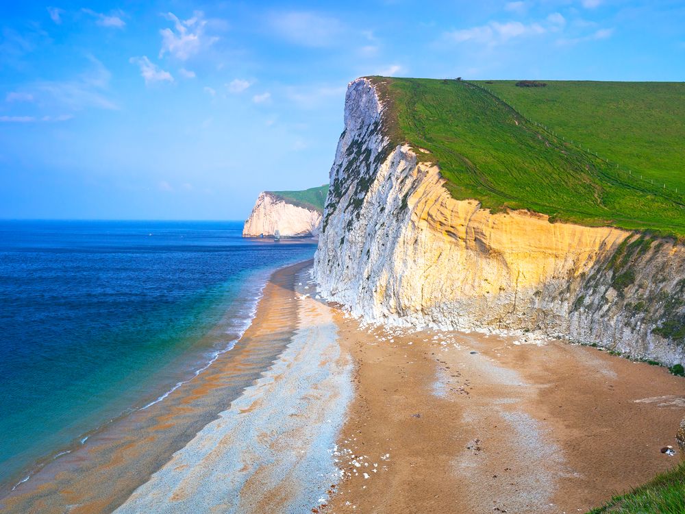
Southern England’s spellbinding, 95-mile Jurassic Coast is one of the world’s most famous coastlines. A UNESCO World Heritage Site and frequent movie set, the Jurassic Coast is the only place in the world that combines rock from the Triassic, Jurassic, and Cretaceous periods, resulting in a natural museum showcasing 185 million years of evolution. Shaped by the tides, winds, and time, the craggy coastline is not only visually spectacular but also a treasure trove for prehistoric fossils. Visitors can hunt for these fossils, visit the local museum, or simply soak up the grandeur of the landscape. Regrettably, this natural wonder won’t be around forever — just as it was shaped, the coastline is always eroding, proof of which is seen in landslides and rock falls that can happen at any time.
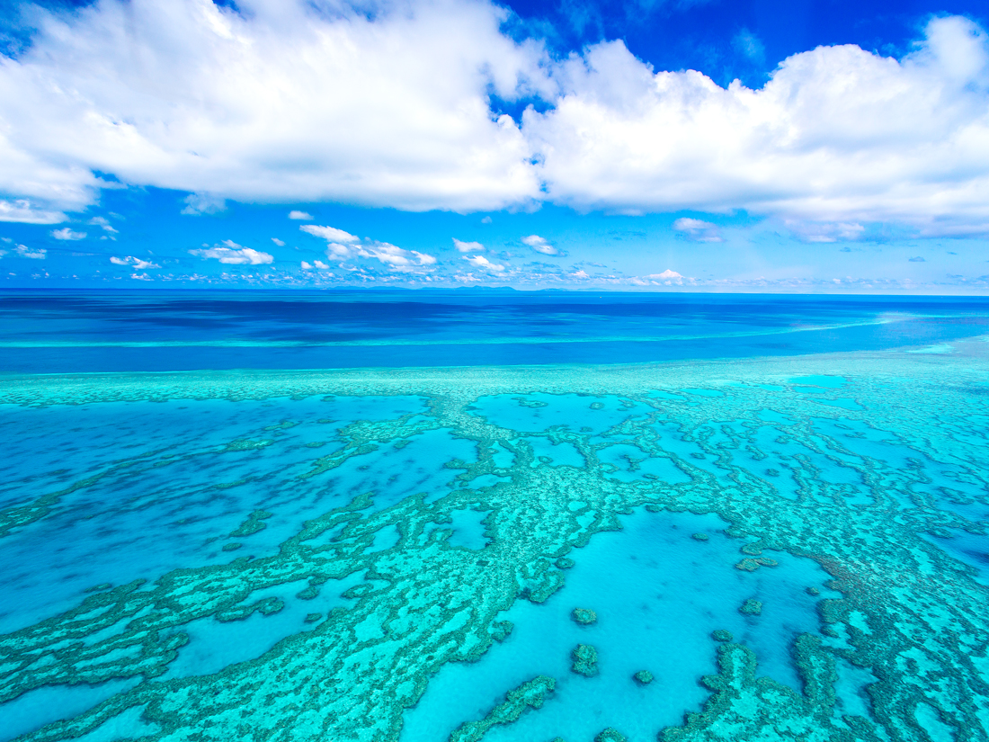
It’s hard to imagine that the largest coral reef system in the world is at risk of disappearing, but it’s unfortunately true. Off the northeast coast of Australia, the Great Barrier Reef stretches nearly 1,500 miles long and is home to approximately 9,000 species of marine life. Due to rising sea temperatures that result in coral bleaching, the Great Barrier Reef has lost over half its corals in the last 30 years, but it’s not the only reef at risk. Reefs in Southeast Asia and the Pacific have lost the largest proportions of their reefs due climate change, pollution, overexploitation, and human disturbances. If you decide to discover the Great Barrier Reef for yourself, make sure to read up on responsible reef practices, which help protect and preserve the marine life that call this fragile ecosystem home.
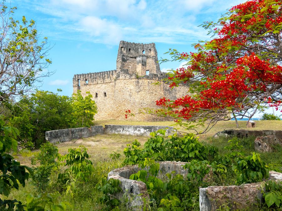
Once a prosperous Swahili port city, the island of Kilwa Kisiwani is a UNESCO World Heritage Site in southern Tanzania renowned for its remarkable and historically significant ruins. The island’s perhaps most noteworthy features are human-made, rather than natural. The Great Mosque was once the largest in sub-Saharan Africa until the 16th century, and the Palace of Husuni Kubwa is known for its grandiose design, including its 16 bays and a massive dome. As the island sits at sea level, its beautifully preserved history is at risk of disappearing. Coastal erosion in the form of waves and rising sea levels are threatening the foundational integrity of the ruins. Fortunately, the Tanzanian government is taking measures to protect the main structures of the ancient city, but despite their best efforts, some small structures and artifacts have already been lost.
Glacier National Park – Montana
Credit: Rachel Lodin/ iStock via Getty Images
Ice loss in Montana’s Glacier National Park has been significant in the last century. When the park was founded in 1910, there were roughly 150 glaciers within its boundaries. Today, just 26 glaciers remain. Glaciers routinely cycle through stages of growth and retreat, but they’ve been unable to regenerate as fast as they’ve retreated in the last few decades. Glacier melt in Glacier National Park — and around the world — is directly linked to rising global temperatures. The good news is that it’s still easy to see a glacier in Glacier National Park —in fact, you don’t even need to leave your car in some cases. Whether it’s via an adventurous multiple-day hike or a leisurely scenic drive, there are plenty of ways to admire these mighty glaciers while they’re still around.
Advertisement
More from our network
Daily Passport is part of Inbox Studio, an email-first media company. *Indicates a third-party property.
A Helpful Guide to Identifying Commercial Aircraft Types
By
Peter Vanden Bos
Read time: 8 minutes
April 2, 2024
Updated: April 2, 2024
A Helpful Guide to Identifying Commercial Aircraft Types
Tips •April 2, 2024•Updated: April 2, 2024
By Peter Vanden Bos
Author
Peter Vanden Bos
Peter is a Toronto-based journalist, editor, content strategist, and self-professed avgeek with 15 years of experience covering all things travel. Prior to joining Daily Passport, he oversaw newsletter publication for Travelzoo. His favorite destinations to explore include Japan, France, Chile, New Zealand, and his adopted home country of Canada.
When traveling by airplane, have you ever stopped to wonder if you’re flying on a Boeing 737 or a Boeing 757 — or what the difference is between them, anyway? To the untrained eye, modern airliners can look quite similar to one another, but if you’re curious about what makes each model different, read on to discover a few helpful tricks for telling commercial airplane models apart.
Most travelers choose flights based on price and convenience, but some seasoned travelers may be looking to fly on a particular model, perhaps because one offers a more comfortable seating layout or a more modern design that might help reduce jet lag. And with recent news surrounding the Boeing 737 MAX, you might be wondering if you can avoid flying on a certain plane type altogether.
Fortunately, major U.S. airlines make it easy to tell what type of aircraft is scheduled to operate each flight. (Word of caution: Aircraft assignments are always subject to change, and usually airlines won’t let you change or refund your flight if that happens.)
When booking on United Airlines, for example, you’ll find the aircraft type next to the flight number, directly under the departure and arrival times to the far left of the page. American Airlines also displays aircraft type under the flight times, right next to the flight number. On Delta Air Lines, you’ll want to click on the hyperlink marked “details” or on the flight numbers, which will introduce a pop-up that has more detailed aircraft information (and also a helpful illustration). Each of these airlines also offers more details on its full fleet of aircraft on their respective websites.
While the big three global U.S. carriers operate many different fleet types, since its first flight in 1971, low-cost giant Southwest Airlines has only flown the Boeing 737. That said, Southwest operates a few different variants — both the older-generation 737-700 and 737-800 and the newer 737-8 MAX models. The airline displays this information during the booking process when you click on the flight number on the flight results page.
What Are the Most Popular Narrow-Body Aircraft Types?
A narrow-body plane has only one center aisle down the aircraft with two to three passenger seats on each side in the main cabin. Wide-body aircraft, on the other hand, have two passenger aisles, with a set of seats along each window and one in the center section between the aisles. If you’re taking a domestic flight anytime soon, chances are high that you’ll be on an Airbus A320 family aircraft or a Boeing 737.
Since the type’s first flight in 1967, more than 15,000 Boeing 737s have been built — more than any other aircraft in history. Today, more than 11,000 Boeing 737s remain in service, and on average, there are two of them landing or departing every five seconds at any given time around the world.
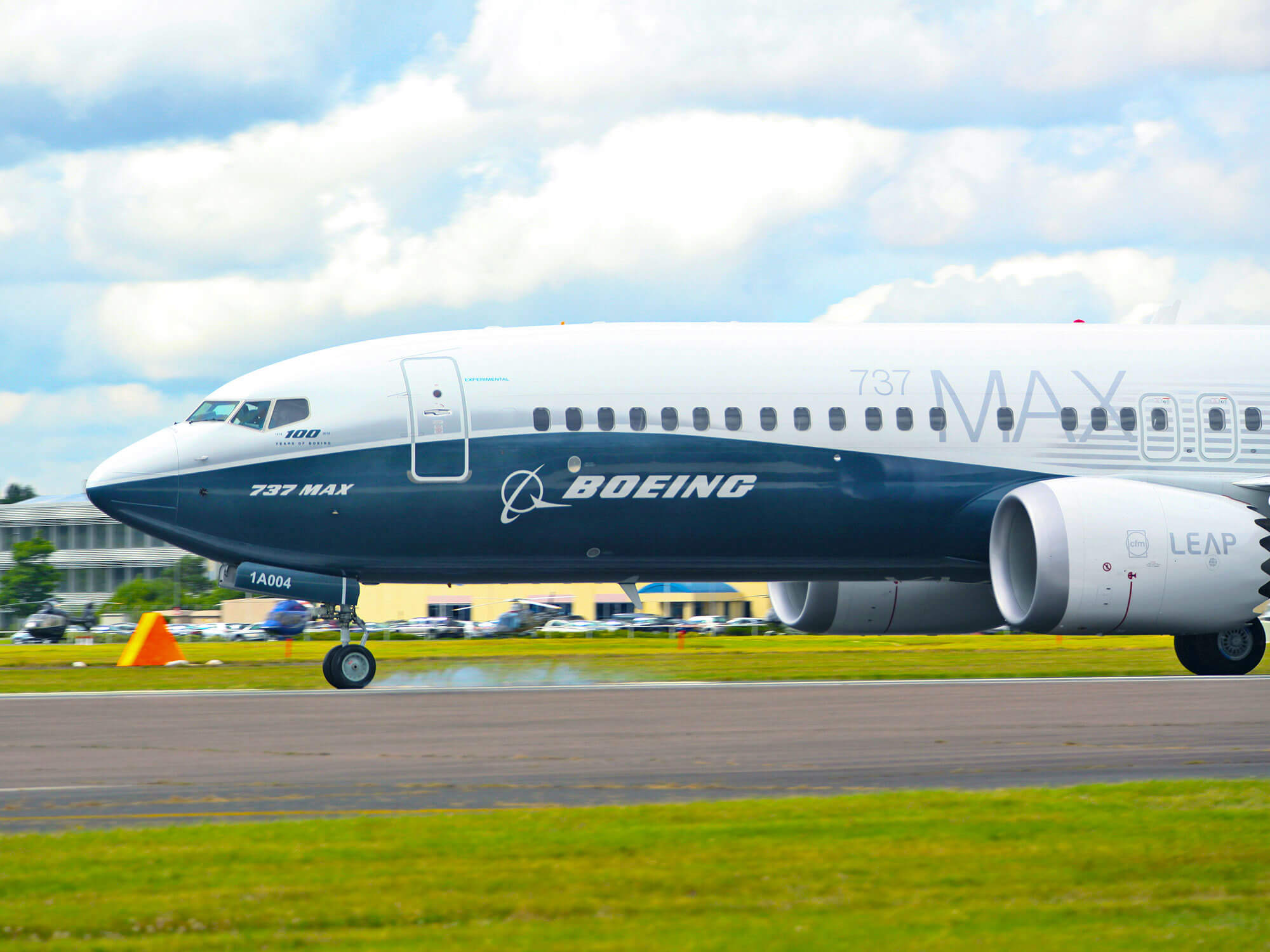
Most older-generation Boeing 737s (including the 737-100, -200, -300, -400, and -500) are no longer flying in the United States. The most common type in service today is Boeing’s “Next Generation” 737, which was introduced in 1997 with refreshed technology. These include the 737-700, 737-800, and 737-900ER (Extended Range) models. In 2017, Boeing unveiled another updated version of the 737 called the 737 MAX with further technology and efficiency updates. As of mid-2024, the 737-8 and 737-9 are flying, while the 737-7 and 737-10 are awaiting certification.
American, Delta, and United each operate several hundred Boeing 737 aircraft. Like Southwest, Alaska’s entire mainline fleet is composed of 737s (the carrier also operates a fleet of regional jets). As of mid-2024, Alaska, American, Southwest, and United also operate dozens of 737 MAXes.
As for other Boeing models, the Boeing 757, first flown in the 1980s, was once a domestic workhouse, but many have been retired in recent years. However, United and Delta still operate large fleets of these aircraft. Consisting of the 757-200 and the longer 757-300 variant, they typically seat between 180 and 230 passengers, and are the longest narrow-body aircraft flying today. The smallest Boeing jet, the 110-seater Boeing 717, is also in service with Delta and Hawaiian Airlines.
The Airbus A320 family has also proven wildly popular. The European manufacturer introduced the type in 1987 with “fly-by-wire” technology, making it the first modern jetliner with a computer-controlled cockpit. Today, more than 10,000 Airbus A320 family aircraft remain in service, including the Airbus A318, A319, A320, and A321 variants (ranked in size order).
Airbus has two generations of the A320 — the original “CEO” (current engine option) and the newer “NEO” (new engine option), which first flew in 2014 with more fuel-efficient engines and other design updates. You can find Airbus models on many major airlines. U.S. airlines such as Frontier, JetBlue, and Spirit, and Allegiant only operate A320-family aircraft, while American, United, and Delta each have large fleets of the type.
One of the newest aircraft types is the Airbus A220, formerly called the CS100, which was introduced in 2013. Airlines such as Air Canada, Delta, and JetBlue are major operators of this model.
Regional Jets
Credit: Kevin Carter/ Getty Images News via Getty Images
You may also likely find yourself on a “regional” jet. Compared to “mainline” jets like the Boeing 737, these aircraft typically seat between 50 and 100 passengers and operate in and out of smaller airports under separate branding (i.e. Delta Connection or United Express). The two largest manufacturers of these smaller jets are Bombardier and Embraer. Bombardier makes the Canadair Regional Jet series, including the CRJ-200, CRJ-700, and CRJ-900 models. Embraer makes the E-jet family — consisting of the E-170, E-175, E-190, and E-195 — and also produces the smaller ERJ-145.
If you’re traveling overseas on a long-haul flight, there’s a good chance you’ll be on a wide-body jet. The Boeing widebody models flying today include the double-decker Boeing 747 (aka the “Queen of the Skies”), the 767, the 777, and the 787. The Boeing 787 is the carrier’s latest-generation type, built primarily with lighter-weight composite materials that make the aircraft more fuel-efficient.
Airbus also has several wide-body models in operation, including the A330, the A340, the A350, and the A380. The A330 and A340 have a similar fuselage, with the latter having four engines instead of two. The A350 is the manufacturer’s newest long-range type, built to compete with Boeing’s 787, and includes the A350-900 and stretched A350-1000 version. Finally, the A380 is the world’s largest passenger jet, which can accommodate between 500 and 800 passengers with two full decks of seating. Sadly, production on the A380 ended in 2021 due to lack of orders.
While most modern jetliners offer similar levels of passenger comfort, not all aircraft are created exactly equal. Notably, the A320’s fuselage is about seven inches wider than the 737. That may not seem like much, but the extra few inches of width gives each economy class seat an extra inch of width on average, and the extra elbow room is noticeable in today’s otherwise cramped cabins.
As far as regional jets, many passengers prefer Embraer’s E-jets (such as the E-175) because the cabin is slightly taller than the Canadair Regional Jet (such as the CRJ-900). That leaves a little more head room, plus space for larger overhead bins. Both models offer two-by-two seating — meaning there’s no middle seat in coach.
Newer wide-body models, such as the Airbus A350 and Boeing 787, also offer improved passenger comfort. The use of carbon fiber materials in their construction increases cabin pressure and reduces humidity, which can ease the effects of jet lag compared with older types. The 787 also features updated passenger-friendly amenities such as extra-large dimmable windows. The A350, meanwhile, is slightly wider than the 787, which allows for slightly wider seats.
Ready to go one step further in your aviation knowledge? True pros can identify the exact aircraft model just by looking at one on the airport runway. There are a few key elements and subtle differences in each aircraft’s design to look out for.
Start with the number of engines. These days, the vast majority of aircraft are twin-engined, so if you see one with four engines it’ll be easier to identify off the bat. Even easier: Two widebody plane types feature a double deck, the Boeing 747 and the Airbus A380 jumbo jet. The 747’s top deck only extends for a small portion at the front of the fuselage, while the A380’s extends the entire length.
Other exterior details to keep an eye on include the shape of the tail fin, the shape of the nose, the layout of the cockpit windows, the landing gear, and the number and type of exit doors along the fuselage of the aircraft.
For example, the Boeing 737 has a noticeably pointier nose design than the rounded one found on the Airbus A320. The 737’s cockpit windows slant upwards and downwards at the bottom, while the A320’s are mostly level. The front part of the 737 tail also has a noticeable triangular protrusion at the base where it meets the fuselage, whereas the A320’s has a small, gentle curve at the base. Finally, the Airbus model sits higher off the ground than its Boeing competitor.
And what about between different variants of the same aircraft family? Start with the exit doors. Because the variants differ by passenger capacity, they usually have a different number of exits. For example, the 737-700 only has one small window emergency exit on each side over the wings on each side. The -800 is slightly larger and features two emergency exits over the wings. The -900 is the longest and features two small emergency exits over the wings and a larger door immediately aft of the wings, which can be plugged if airlines choose to configure the plane with fewer than the maximum number of seats.
The 737-9 MAX also features the optional larger exit door directly aft of the wing, similar to the 737-900ER. These can also be deactivated based on airline seating configuration. The plugged exit door made headlines in January 2024 when it detached from an Alaska Airlines 737-9 MAX shortly after takeoff, prompting the worldwide fleet to be grounded and inspected before it could safely return to service several weeks later.
Advertisement
More from our network
Daily Passport is part of Inbox Studio, an email-first media company. *Indicates a third-party property.
Daily Passport writers have been seen in publications such as National Geographic, Food & Wine, CBC, Condé Nast Traveler, and Business Insider. They're passionate about uncovering unique destinations and sharing expert tips with curious travelers.
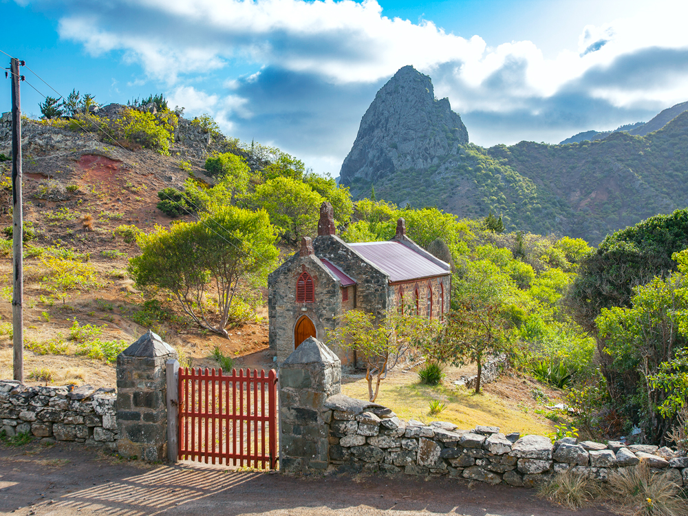
The planet is dotted with islands, some home to millions of people and others small, rocky outcrops located thousands of miles from the nearest continent. Given their geographic isolation, often the people who inhabit Earth’s many islands develop unique cultural identities or use them for fascinating purposes. That’s certainly the case with the islands beow. From an Irish island home to a community of monks for centuries to the island where infamous ruler Napoleon Bonaparte met his fate, these are seven of the world’s most interesting islands.
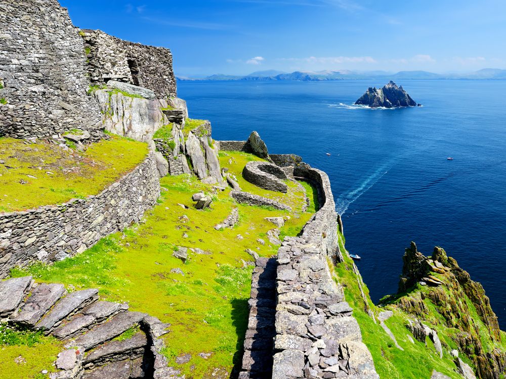
Skellig Michael – Ireland
Credit: MNStudio/ iStock via Getty Images
Skellig Michael (Sceilg Mhichíl in Irish) — a rocky, green outcropping 12 miles off Ireland’s southwest coast — doesn’t look all that inviting from shore. That was exactly its attraction for the community of monks who took up residence there in the sixth and seventh centuries CE. Early Christians sought austerity and solitude, and the island offered those in abundance. For 600 years, monks lived on Skellig Michael in stone beehive huts (so named for their rounded and tapered shape), perched on human-made terraces on the rocky island slopes along with a hermitage, church, garden, and cemetery. The monks subsisted on what vegetables could be grown on this wind-whipped island, the fish that could be caught in the wild sea below, and the eggs of the large colony of gannets and puffins.
Around the 13th century, the monks decamped for the mainland, but the island remained a place of pilgrimage. It was added to UNESCO’s World Heritage list in 1996, with the notation that — except for some destruction wrought by Vikings and 19th-century lighthouse construction crews — Skellig Michael has been protected by its isolation. In 2015 and 2017, film crews swarmed the monks’ island during production of two Star Wars movies, The Force Awakens and The Last Jedi, introducing its solitary beauty to film audiences worldwide.
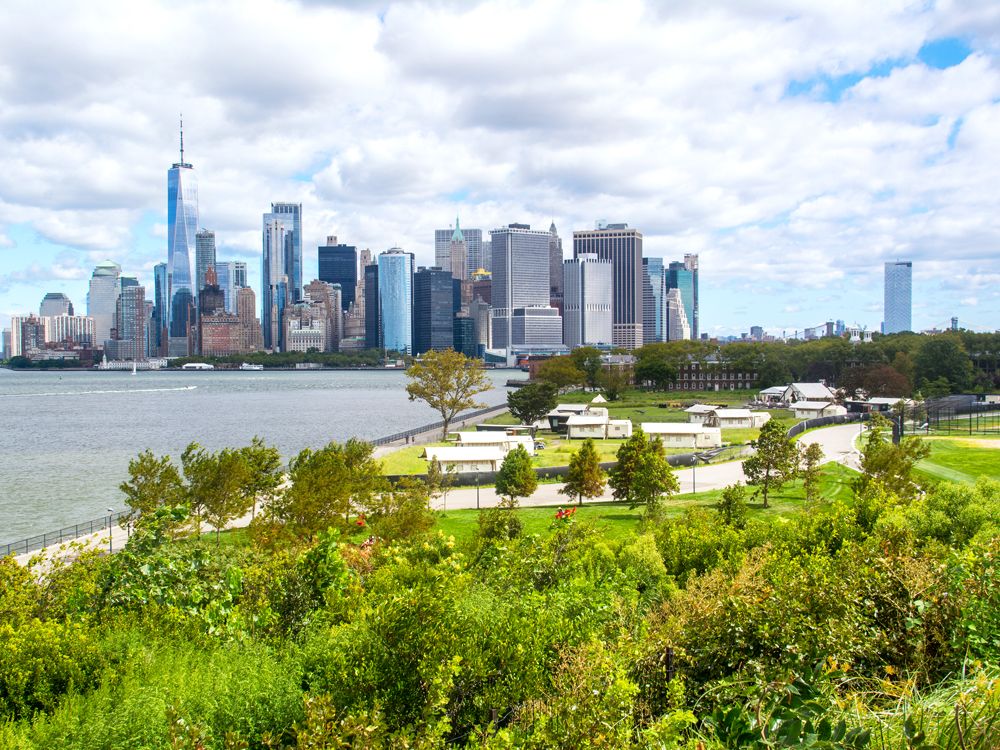
Governors Island – New York
Credit: Robi_J/ iStock via Getty Images
Despite its location just a few hundred yards off the southern tip of Manhattan, serene Governors Island couldn’t have more of a different feel from Manhattan’s concrete bustle. The 172-acre island — located in New York Harbor at the confluence of the Hudson and East rivers — was originally inhabited by Lenape Native Americans, who named it Paggank (“Nut Island”) after its plentiful nut trees. The British colonial assembly in New York later designated it for private use of its royal governors, which is how the island got its current name. It then served as an important military fortification, part of a larger coastal defense network, and after that, it served as the largest U.S. Coast Guard base for 30 years.
In 2003, the island was designated as the Governors Island National Monument, and in 2012, the island was opened to the public as a seasonal park, accessible by a quick ferry ride. The park hosts a number of seasonal concerts and events, including the Jazz Age Lawn Party, and even has overnight glamping accommodations. The southern end of the island features the longest slide in the city, and visitors can enjoy leisurely bike rides, a nap in a hammock, and a waterfront promenade — alongside panoramic views of Lower Manhattan, Brooklyn, and the Statue of Liberty.
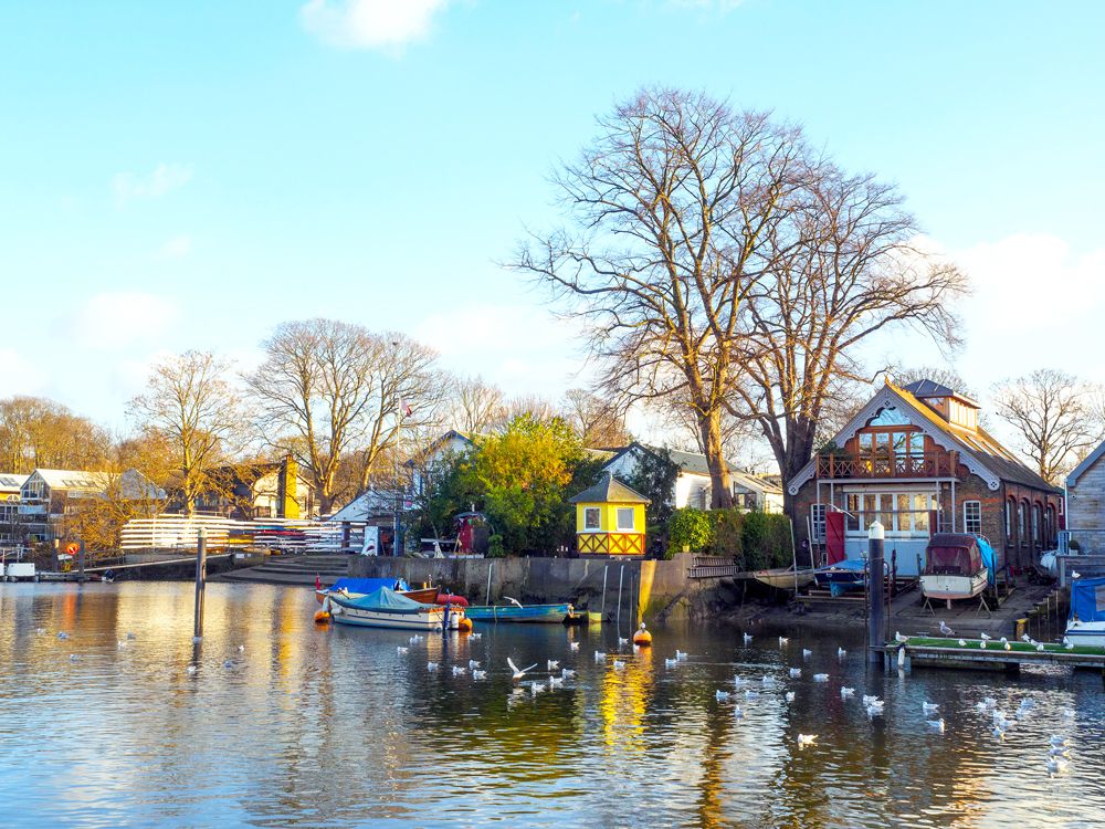
The only inhabited island in the Thames River, Eel Pie Island was supposedly named after a traditional Victorian-era working class dish, which made use of the plentiful eels off the island’s shores. But rather than eel pies, the island has long had a reputation as a hotbed for hippies to party. Though a pedestrian bridge now connects it to the mainland, the island was long accessible only by boat — providing privacy to those in search of recreation and a fresh air escape from London.
Originally a 19th-century retreat, the Eel Pie Island Hotel was rebuilt and reopened, with the addition of a dance hall in the 20th century. The tasteful tea dances of the 1930s and 1940s gave way to less respectable jazz shows in the 1950s, all leading up to a period that cemented the island’s reputation as a birthplace of British R&B music. In 1963, the Rolling Stones played a regular Wednesday night gig at the hotel, and, before the building mysteriously burned down in 1971, its stage also hosted the likes of Genesis, Pink Floyd, John Mayall’s Bluesbreakers (with young Eric Clapton on the guitar), the Yardbirds, and Black Sabbath. Today, the secluded nine-acre island is inhabited by a community of artists who invite the public twice a year for open studio events. Another small group of residents live a clutch of houseboats moored to the island’s Thames-facing side.
On the basis of its landscapes alone, the southernmost, largest, and youngest island in South Korea — and home to the nation’s highest mountain, Hallasan — would be worth visiting. A wonderland of lava tube caves, geometric stone pillars, and other stunning remnants of long-ago eruptions, Jeju has been designated a UNESCO Global Geopark, Biosphere Reserve, and World Heritage Site. (The site was also a plot point on Squid Game, the South Korean TV show that became a global phenomenon via Netflix.)
But for all of Jeju’s UNESCO-anointed nature, an entry on the organization’s Intangible Cultural Heritage list piques at least as much interest in the island: the Haenyeo, or “sea women.” Carrying on a centuries-old local tradition, these remarkable female divers harvest seafood from the ocean floor on nothing but their own lung power. The typical dive may take them to depths of more than 30 feet (and back) in just a couple of minutes. That’s all the more impressive when you consider that the women are mostly 60-plus years old — in recent decades, their numbers have dwindled as women have left the island and opted for more modern work. However, their ranks still include trainees, who learn from the most experienced divers (called sanggun) and schools exist to reinforce that training and preserve associated traditions. To learn more, you can visit the island’s Haenyeo Museum or catch the demos at Seongsan Ilchulbong.
St. Helena Island – British Overseas Territory
Credit: Uwe Moser/ iStock via Getty Images
Elba, off the coast of Italy, wasn’t the only island Napoleon Bonaparte was exiled to — the emperor met his demise on an island so remote that the nearest major landmass is 1,200 miles away. Covering only 47 square miles in the South Atlantic, St. Helena Island is one of three islands that make up the British overseas territory of St. Helena, Ascension, and Tristan da Cunha. Despite its remote location and tiny size, St. Helena Island has a rich history: In addition to Bonaparte — whose Longwood House is now a museum — the island has welcomed naturalist Charles Darwin, explorer James Cook, astronomer Edmond Halley, and Dinuzulu (the last king of the Zulus).
Even more alluring than the history are the island’s natural wonders. With almost no light pollution, stargazing is magnificent. Underwater, divers revel in reefs and shipwrecks humming with fish, rays, and turtles. Animal lovers should look out for quirky endemic birds, spiders, and snails — plus the opportunity to swim with whale sharks or spot humpback whales and their calves. The volcanic island offers plenty of rugged terrain for hikers, too. And thanks to an airport that opened in 2017 and replaced a six-day boat journey from South Africa, St. Helena is, finally, more accessible than ever before.
This rugged 37-mile-long barrier island — two-thirds in Maryland, the rest in Virginia — beckons visitors with unspoiled sandy beaches, salt marshes, hiking trails, and numerous campsites. But unlike other islands in the Chesapeake Bay, this one is home to a herd of majestic wild horses, who have roamed there for hundreds of years.
No one is sure how exactly the horses got to Assateague Island. A popular local legend says they swam to the island after surviving the shipwreck of a long-lost Spanish galleon. But other experts have a somewhat less exciting theory: that colonists brought horses to Assateague from the mainland to avoid taxation and simply left them there. Whatever the reason, the feral horses now roam freely on both sides of the island, except for once a summer, when thousands of spectators gather on boats in the bay or on the beach to watch the annual pony swim. “Saltwater cowboys” swim the herd’s ponies across the narrow channel to nearby Chincoteague Island, kicking off a week-long event that celebrates Assateague’s unique history.
Mont-Saint-Michel – France
Credit: zwawol/ iStock via Getty Images
One of Europe’s most enchanting medieval vistas is this Benedictine abbey that dominates a small tidal island just off the coast of Normandy. If it appears straight out of a Disney film, that’s because it is: The magical island inspired Disney animators when they drew up Rapunzel’s birthplace in the 2010 film Tangled. The island’s namesake abbey flaunts slender spires that jut up from the surrounding rocky cliffs, with architecture that dates back to the eighth century. Remarkably left intact following the Hundred Years’ War and both World Wars, Mont-Saint-Michel is now a UNESCO World Heritage Site that welcomes more than 3 million visitors annually.
The changing tides of Mont-Saint-Michel present a fascinating contrast: As tides recede, a bed of shimmering, sifting sand appears as a cushion around the island, but when waters are high, it seems to float in the bay. The abbey was cut off from the mainland until the late 19th century, but visitors can now cross a bridge to discover a walled village of narrow cobblestone alleys and stairways, home to restaurants, hotels, and a full-time population of just 30 people.
Advertisement
More from our network
Daily Passport is part of Inbox Studio, an email-first media company. *Indicates a third-party property.
Rachel is a Washington, D.C.–based travel and lifestyle writer with roots in the Great Lakes region. When she’s not writing for publications such as The Discoverer and Interesting Facts, you’ll find her wandering through museums or exploring destinations off the beaten path.
The most sought-after travel accessory isn’t a designer carry-on bag or the latest wireless headphones — it’s a powerful passport. This essential companion to any international journey paves the way to new adventures and destinations, but not all passports are created equal. While some may offer unrestricted access to nearly 200 countries, others require users to secure a pretravel visa for most destinations. So, which countries boast more passport privileges than others? To find out, we turned to the Henley Passport Index, an annual guide to passport strength. Discover the world’s most powerful passports in 2026.
For the past 20 years, the Henley Passport Index has ranked passports by the number of countries a holder can enter without obtaining a prior visa. It compares 199 passports and 227 travel destinations, awarding one point for each destination the passport holder can enter without a visa.
A visa is a document issued by the destination country to a traveler that allows entry for a specified period of time. Obtaining a visa before travel can be time-consuming — possibly requiring applications, medical screenings, interviews, and more. Because of this, visa-free entry to foreign countries is desirable for travelers.
Considered the gold standard for assessing a passport’s global mobility, the Henley index is based on exclusive data from the International Air Transport Association (IATA). These rankings are updated monthly based on international travel regulations and political and economic events, providing the most up-to-date data in the industry.
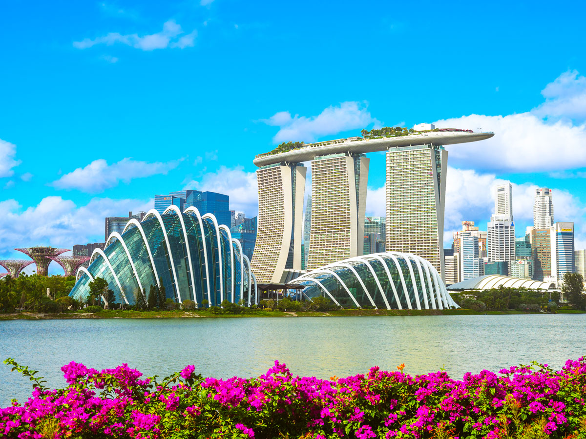
One country has remained at or near the top of the Henley index — in first or second place — since 2018. And in 2026, Singapore‘s passport is as strong as ever. The city-state retains its position as the world’s most powerful passport in 2026, with unrestricted access to 192 destinations.
In a tie for second place are Japan and South Korea, both of which provide visa-free access to 187 destinations. Sweden and the United Arab Emirates are tied for third place, meaning they have the strongest passports in Europe and the Middle East, respectively, entitling visa-free access to 186 nations. Interestingly, the UAE has the biggest comeback story within the ranking, increasing its reach from 35 destinations in 2006 to 186 today.
Overall, Europe is a powerhouse when it comes to passport strength. Twelve European countries are tied for fourth place, each boasting access to 185 countries: Belgium, Denmark, Finland, France, Germany, Ireland, Italy, Luxembourg, the Netherlands, Norway, Spain, and Switzerland. Fifth place (with access to 184 countries) is a four-way tie among Austria, Greece, Malta, and Portugal.
Although Asian and European passports dominate the top rankings, other regions are not far behind. Two of the most populous countries in Oceania, New Zealand (183) and Australia (182), rank sixth and seventh, respectively. Along with Australia, the United Kingdom is part of a six-way tie for seventh place.
In North America, Canada (181) ranks eighth, falling one spot since last year’s report. Similarly, the United States (179) fell from ninth to 10th place year over year. Compare that with 2014, when the U.S. and the U.K. jointly held the No. 1 spot in the ranking. Over the past year, the U.S. lost visa-free access to seven destinations, while the U.K. lost access to eight.
One of the most notable takeaways from the 2026 index is that the gap between the highest and lowest passport mobility has widened since the Henley Passport Index’s debut year in 2006. Today, there is a 168-destination gap between the highest-ranking passport, Singapore (with visa-free access to 192 destinations), and the lowest, Afghanistan (24). Twenty years ago, this gap was 50 nations smaller. Afghanistan’s passport, which ranks last in the index, currently offers visa-free access to 24 destinations, down from 26 since last year.
Traveling for a Game? These Are the 7 Largest Stadiums in America
By
Daily Passport Team
Read time: 4 minutes
April 2, 2024
Updated: April 3, 2024
Traveling for a Game? These Are the 7 Largest Stadiums in America
Architecture •April 2, 2024•Updated: April 3, 2024
By Daily Passport Team
Author
Daily Passport Team
Daily Passport writers have been seen in publications such as National Geographic, Food & Wine, CBC, Condé Nast Traveler, and Business Insider. They're passionate about uncovering unique destinations and sharing expert tips with curious travelers.
Many sports fans travel across state lines for the chance to root for their favorite teams in a different city. If you’re a fan of football, you’ll often find yourself in stadiums that hold upwards of 100,000 spectators. These feats of architecture and engineering can be just as much a highlight as the game itself. Curious about which stadiums in the U.S. hold the most fans? Visit America’s seven largest stadiums below.
The University of Alabama’s Bryant-Denny Stadium in Tuscaloosa — home of the Alabama Crimson Tide football team — first opened in 1929. This massive stadium now has a capacity for a whopping 101,821 spectators. While that might sound like an unattainable amount of seats to fill, the stadium regularly sells out for big games. More than 38,000 students are enrolled at the University of Alabama, which was inaugurated in 1831. A stroll through this beautiful campus — or even a guided tour — is a must if you find yourself in western Alabama.
With an official capacity of 102,321, Tiger Stadium at Louisiana State University was originally completed in 1924 but has had multiple improvements to get to its current (enormous) size. Also known as “Death Valley,” Tiger Stadium was last expanded in 2014, increasing its capacity to make it the sixth-largest stadium in America.
Since opening in 1921, Neyland Stadium has been the home of the University of Tennessee Volunteers football team. Named after U.S. Army General Robert R. Neyland, a former football coach for the Volunteers, this stadium has a long history in American football in the South. It has drawn more than 25 million fans through its doors since its beginning, and today has a capacity of 102,455 fans at each game.
Football is a staple in Texas, so it’s no wonder that Texas A&M University in College Station is home to the fourth-largest stadium in the U.S. Here, up to 102,733 fans can catch an Aggies football game — significantly more than the original capacity in 1929 of just 32,000. Visitors can even go on guided tour with field access, views from the top, and a brief history of the venue. The so-called “Home of the 12th Man” underwent a massive $450 million renovation that was completed in 2015, bringing it to its current size.
The Ohio State Buckeyes’ home stadium has had quite an upgrade from its original capacity of 66,210 back in 1922. Thanks to a 2014 expansion, this stadium can now hold a whopping 102,780 fans. The largest crowd that this stadium has seen was 110,045 back in 2016 when the Buckeyes played Michigan. Check out Ohio State Stadium Tours to walk the sidelines, visit the press box, and more at this famous venue.
The Penn State Nittany Lions are lucky enough to call America’s second-largest stadium their home field. With a capacity of 106,572, Beaver Stadium is one of the nation’s most well-known sports facilities and the oldest on this list. The 500-seat Beaver Field got its start in 1893 with the first game played against Western Pittsburgh University, which would later become the University of Pittsburgh — a rival to this day. Visitors might have a chance for an exclusive tour by contacting the Penn State All-Sports Museum.
1. Michigan Stadium – Ann Arbor, Michigan
Credit: Ezra Shaw via Getty Images Sport
The largest stadium in the United States, and second-largest in the world, belongs to another school from the Big Ten, the University of Michigan. The “Big House” certainly lives up to its nickname with seating for up to 107,601 people, and over the years it has hosted crowds well over its official capacity for big rivalry games — sometimes in excess of 115,000. A tour of this stadium is a must during your southern Michigan trip. Visitors can even walk through the famous tunnel onto the field.
Advertisement
More from our network
Daily Passport is part of Inbox Studio, an email-first media company. *Indicates a third-party property.
How to Score a First Class Upgrade for Cheaper Than You Think
By
Peter Vanden Bos
Read time: 5 minutes
April 2, 2024
Updated: November 13, 2025
How to Score a First Class Upgrade for Cheaper Than You Think
Tips •April 2, 2024•Updated: November 13, 2025
By Peter Vanden Bos
Author
Peter Vanden Bos
Peter is a Toronto-based journalist, editor, content strategist, and self-professed avgeek with 15 years of experience covering all things travel. Prior to joining Daily Passport, he oversaw newsletter publication for Travelzoo. His favorite destinations to explore include Japan, France, Chile, New Zealand, and his adopted home country of Canada.
Cramped seats, packed overhead bins, tiny bags of pretzels (if anything at all) — it’s all par for the course when it comes to flying these days. But while that may be true of economy class, it’s a much different story if you’re lucky enough to be flying in first class. Booking a first or business class seat gives travelers more room to stretch out, personalized service, complimentary in-flight meals and cocktails, and a host of other perks that might just make you forget what it’s like flying at the back of the plane. Many travelers think expensive first-class tickets are out of reach, but you might be surprised to learn that there are ways to score that seat upgrade for less than you think. Read on to discover four ways to fly first class for less.
Make Use of Your Frequent Flier Miles
Credit: Westend61 via Getty Images
You’ve probably already enrolled in one or more airline frequent flier programs, so make sure to add your frequent flier number to your itinerary each time you fly. You’ll rack up points based on the money you spend on airfare or the number of miles you fly (except for some basic economy tickets) and you can later cash these points in for free flights. Essentially, you’re getting cash back every time you fly. Plus, if you have a co-branded airline credit card or a travel rewards credit card, you can easily add to your stash by earning miles from everyday spending.
In addition to redeeming miles for a new booking, most airlines will allow you to upgrade an existing ticket to a higher cabin using frequent flier points, cash, or a combination of both. While carriers such as American Airlines publish a handy chart detailing the number of miles needed to upgrade, others such as Delta Air Lines have variable pricing. In those cases, you’ll want to log into your itinerary on the airline’s website or app and see how much it costs to upgrade your seat. You’ll typically see both a cash price or a points price — if you’ve already got the hard-earned points from previous flights, it’s a great way to score an upgrade without paying for it out of pocket.
Achieve Elite Status — or Travel With Somebody Who Has It
Credit: Frazao Studio Latino/ E+ via Getty Images
While there’s probably no such thing as a “free” upgrade anymore, the closest you can get is by achieving elite status with an airline. Fly (and spend) a certain amount each year, and you’ll be rewarded for your loyalty with perks like priority service, free bags, and waived fees. Perhaps the most coveted perk of all is the complimentary upgrade.
If any first-class seats on a flight remain unsold by the time of departure, airlines — including Alaska, American, Delta, and United — will offer their elite members space-available upgrades, prioritized based on their elite status tier. These complimentary upgrades are typically available on flights within North America, to the Caribbean, and to some destinations in northern South America. These types of complimentary upgrades usually aren’t offered on long-haul international flights; however, top spenders in these frequent flier programs can sometimes acquire upgrade certificates that can be used for any destination the airline flies to.
Don’t have elite status? Many programs will allow the elite member to also upgrade companions traveling with them for free — even if they don’t hold any status with the airline. Or, if a friend or family member with elite status won’t be able to use all their upgrade certificates, they might be able to upgrade you instead. Finally, some airline credit cards offer elite-like perks — for example, cardholders of the Delta Reserve Card are eligible for complimentary first-class upgrades once all elite members have been cleared from the upgrade list.
Keep an Eye Out for Discounted Upgrades Closer to Check-In
Credit: d3sign/ Moment via Getty Images
Of course, for airlines, it’s better to sell a first-class seat than give one away for free. If any premium seats remain unsold close to the departure date, airlines will often try to incentivize last-minute upgrades to fill the cabin. For example, Air Canada offers a “Last Minute Upgrade Purchase” option during check-in if seats are available — often for far less than to book a first-class seat outright. The airline (like many others) also allows travelers to place a bid on an upgrade to a premium seat up to 48 hours prior to departure, which can be another way to score a cheap first-class upgrade.
It also doesn’t hurt to ask the agent at the check-in counter or gate about any upgrade possibilities. While there’s a slim chance of scoring a free upgrade just for looking the part, you might be offered an attractive price. That’s particularly true if the flight is oversold — if you volunteer to take a later flight, you can negotiate an upgrade to a higher cabin as part of your compensation for being flexible.
Or, Just Book a Premium Fare From the Start
Credit: BJI / Blue Jean Images/ blue jean images via Getty Images
At the end of the day, some travelers aren’t willing to roll the dice on a last-minute upgrade. If you prefer peace of mind knowing you have a comfortable travel experience ahead of you, consider searching first or business class seats from the start instead of hoping for an upgrade later.
The best way to find discounted premium cabin fares is by using Google Flights. The site’s handy calendar feature makes it easy to find the lowest fares — just enter your origin and destination, number of passengers, and type of trip (round-trip, one-way, or multi-city), making sure to specify first or business class for the class of service. You don’t even need to have a specific route pairing in mind — the site also has a map feature to explore destinations with attractive pricing.
A good rule of thumb is to search for days of the week that have less demand from business travelers — typically Tuesdays, Wednesdays, and Saturdays. And if you’re flexible, consider flights with off-peak departure times such as early in the morning or late at night.
Finally, certain credit card programs also offer their cardholders handy tools for securing cheap first-class flights. For example, cardholders of the American Express Platinum Card have access to the International Airline Program, which provides discounts on first, business, and premium economy fares on participating airlines. Cardholders can also use their points to upgrade an existing ticket.
Advertisement
More from our network
Daily Passport is part of Inbox Studio, an email-first media company. *Indicates a third-party property.
Daily Passport writers have been seen in publications such as National Geographic, Food & Wine, CBC, Condé Nast Traveler, and Business Insider. They're passionate about uncovering unique destinations and sharing expert tips with curious travelers.
Nothing livens up a vacation like a bold splash of color. When visiting new places, it’s often the colorful architecture and rainbow-hued landscapes that stick out in our memories — and make for the best vacation photos. From Morocco’s famed “Blue City” to the jewel of Colombia’s Caribbean coast, these are 12 of the most colorful cities you can visit around the world.
In Jaipur, the capital of India’s Rajasthan province, pink is everywhere. That’s thanks to the many buildings around town that showcase the area’s local sandstone and its naturally pink tint. Although the planned city dates to 1727, Jaipur doubled down on the rosy hue in 1876, when it painted many of its ornate palaces an even bolder shade of pink to impress Queen Victoria’s visiting husband, Prince Albert. Since then, Jaipur has cemented its status as “the Pink City,” wooing romantics from all over the globe.
The city is dotted with many impressive palaces and temples, but the grandest piece of architecture in Jaipur is undoubtedly the Hawa Mahal (or Palace of Winds), a 1799 addition to the sprawling central palace. The 953 windows of Hawa Mahal are obscured by decorative stone-carved screens, which permitted women of the royal family to gaze outside without being seen, in order to adhere to the strict religious codes of the time. The distinctive five-story palace is stunning any time of day, but in the early morning, the sun illuminates its rosy facade at its pinkest.
San Miguel de Allende, Mexico
Credit: bpperry/ iStock via Getty Images
In a country of colorful cities, San Miguel de Allende still manages to stand out. Nestled in central Mexico’s highlands, San Miguel de Allende was originally an Indigenous Chichimeca village called Itzcuinapan until the arrival of the Spaniards in the 16th century. A Franciscan monk named Juan de San Miguel built a chapel in the village in 1542, and the outpost grew in wealth and power as a market for the silver and tin mined in the region. Today it’s a haven for expats, artists, and tourists drawn to its magnificent and well-preserved colonial architecture — recognized as a UNESCO World Heritage Site — as well as the city’s vibrant cultural and culinary scenes.
The Parroquia de San Miguel Arcángel, a neo-Gothic confection with soaring pink towers that’s often compared to a wedding cake, dominates the city’s historic center. A nearby artisan market is bursting with exquisitely crafted jewelry, brightly painted pottery, and hand-woven textiles. On Saturdays, local cuisine takes center stage at the Tianguis Organico, where sellers offer the region’s bounty of honey, cheeses, chocolates, tamales, and more tasty treats. For a bit of exercise and a spectacular view, take a 15-minute stroll from downtown up to El Mirador, a popular tower with a panoramic overlook of the city.
Sintra, Portugal
Credit: Chiara Salvadori/ Moment Open via Getty Images
Though it’s only an hour outside of Lisbon’s hilly cobblestone streets and lively plazas, arriving in Sintra feels like stepping out of Portugal and into the pages of a fairy tale. The entire town comprises a UNESCO World Heritage Site for its dazzling display of European Romantic architecture — perhaps no better illustrated than by Pena Palace.
Splashed in bold hues of red and yellow, Pena towers over the surrounding hills and straight out to the sea — a fantasy of graceful arches, intricate marble carvings, and dazzling tile mosaics. The site began as a humble hilltop chapel in the Middle Ages (after a reported sighting of the Virgin Mary) and served as a monastery for centuries before falling to ruins. King Ferdinand II purchased it in the 1830s to transform the decrepit site into a royal summer residence. Combining architectural elements from many electric styles, the castle as it appears today was completed in 1854.
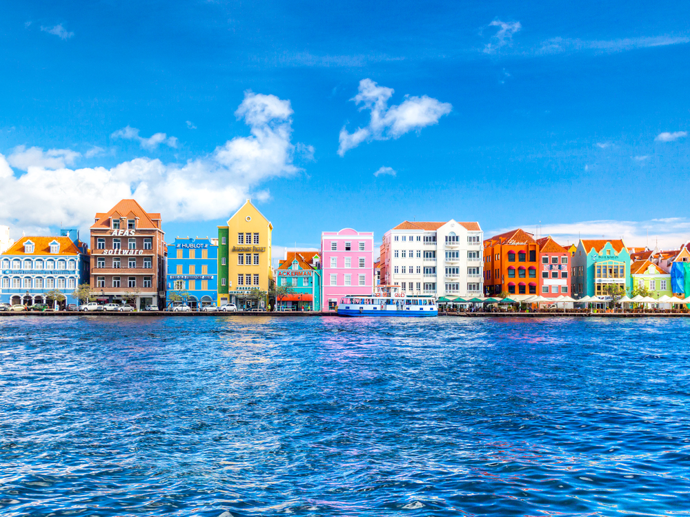
Willemstad, Curaçao
Credit: Tim Drivas Photography/ Moment via Getty Images
If Amsterdam were small and surrounded by alluring beaches, it would be the colorful Caribbean capital of Willemstad, on the Dutch island of Curaçao. Located 40 miles off the coast of Venezuela, the island itself is only 170 square miles, and Willemstad covers about a third of its area, spreading out around the harbor of Schottegat. Sint Anna Bay separates the city, opening onto a sea as blue as the citrus peel-based liqueur that bears the island’s name.
Four of Willemstad’s neighborhoods combine to form a UNESCO World Heritage Site, recognized for their historic value. Punda, the oldest, sprang up near Fort Amsterdam, which the Dutch built in 1634 after wresting control of the island from Spain. Stroll across the unique Queen Emma Bridge to the neighborhood of Otrobanda, which bustles with shops, galleries, and restaurants serving delicious seafood with both European and West African influences. From here, you can look across the water to postcard-perfect Handelskade — its bright pastel buildings are reminiscent of the tall and narrow homes of the Netherlands.
The oldest city in Canada — indeed, the oldest city established by the English in all of North America — is St. John’s. Established in 1497, St. John’s is the capital of the province of Newfoundland and Labrador. A Royal Charter issued by Queen Elizabeth I on August 5, 1583, officially claimed the city as part of British territory before Canada became independent. Despite the city’s age, it was not officially incorporated into a city until May 1, 1988.
Its long history, picturesque harbor, and beautiful architecture make St. John’s a well-known tourist destination for not only Canadian travelers, but also international visitors. One of the most popular areas to visit is Jellybean Row, the nickname given to the brightly painted houses that are a landmark of St. Johns. According to local lore, the unusual paint job was a way of helping the island’s fishermen find their way home in the fog. This may or may not be true, but the modern practice dates to the 1970s when someone had the idea to brighten up the town, and the trend caught on.
Chefchaouen, a city high in the Rif Mountains of northwest Morocco, is called the “Blue City” or “Blue Pearl” for reasons that become clear the instant you arrive. The kasbah — a walled perimeter once used as a fortress to protect against Portuguese crusaders — is painted an enchanting spectrum of every shade of blue imaginable. The town is no longer confined by the kasbah, yet neighboring homes, mosques, and government buildings have adopted the striking palette as well. Cerulean-washed walls cool the steep and narrow streets, and the many cobalt-stained doors and windows, turquoise flower pots, and lapis stone steps only add to the city’s enchanting appeal.
Some say the local hue — which holds spiritual significance in Judaism — is a contribution of Jewish refugees who settled here during the Spanish Inquisition. The area began to attract attention as part of a popular backpacking circuit in the 1960s, and has exploded in popularity during the Instagram age. Some places are unbelievably better in person than in photos, however — and Chefchaouen is surely one of them.
The jewel of Colombia’s northern coast, Cartagena is one of the best-preserved colonial cities in Latin America, well deserving of its nickname the “Queen of the Caribbean.” Still surrounded by its original walls — which stretch almost seven miles around the port and old city — the historic quarter enchants with colorful streets and lovingly maintained colonial architecture that dates back to the 16th century. Cartagena was once an important trade center for the Spanish empire, which constructed the fortifications to protect the colony’s bounty of gems, crops, and other riches against pirate invasions.
Now a UNESCO World Heritage Site, the wall and old city are suffused with a friendly, fun-loving vibe. Stroll the streets along the wall (a leisurely pace will cover it in about two hours) and be sure to stop at one of the many bars atop the wall for a spectacular view at sunset. Local dancers perform daily at Plaza Bolívar, and while you’re there, don’t miss the fascinating treasures at the Zenú Gold Museum.
Once the province of nomadic Indigenous fishing peoples, the city of Valparaíso was founded on the Chilean coast in 1536 by the conquistador Juan de Saavedra, who hailed from Spain’s Valparaíso de Arriba and named it after his native village. Though the beginning of the colonial era was relatively quiet along this stretch of the Pacific (with the exception of the occasional pirate attack or earthquake), the years leading up to Chile’s independence from Spain in 1818 saw the development of a major port here. During the subsequent Republican era, that infrastructure made Valparaíso a hub of international trade — which in turn brought entire communities of European immigrants.
That cosmopolitan legacy remains on view throughout the city center of Valparaíso, now listed as a UNESCO World Heritage Site. Among the attributes that qualified this historic quarter as World Heritage-worthy: the many charming squares, incredible lookout points, meandering promenades, and Valparaíso’s unique funicular elevators. The seaside city is unlike any other in Chile: an intoxicating blend of bohemian architectural and bold colors, and a place that inspired some of the country’s most famous artists, including poet-turned-politician Pablo Neruda.
Old San Juan is a small islet that’s connected to the rest of the San Juan area by three bridges. This historic spot is the most-visited area of Puerto Rico, and it’s easy to see why it’s so popular — the sloping cobblestone streets are lined with houses in every vibrant shade imaginable. From most spots on the island you’ll also have stunning views of the Caribbean Sea, and no matter where you are, you’ll be surrounded by vivid colors everywhere you turn. When you aren’t taking in the views, Old San Juan has plenty of things to do. Take some time to visit 500-year-old forts, explore La Fortaleza palace, or visit one of the island’s many museums.
In 17th-century Greenland, there were no street names or numbers, so buildings were painted according to the purpose of each structure. For example, yellow represented a hospital or a doctor’s house; red buildings were schools or churches, and police stations were black. Green buildings were industry-related, while blue represented fishing. Today, Greenlanders keep the tradition alive by painting their houses all sorts of bright colors.
In the local language, Ilulissat — Greenland’s most-visited town — appropriately translates to “icebergs.” Ilulissat neighbors the Ilulissat Icefjord, home to thousands of icebergs that have calved from the Sermeq Kujalleq glacier, the fastest-moving glacier on Earth. A major outlet of the Greenland ice sheet — which formed more than 250,000 years ago and covers 80% of the country — the Sermeq Kujalleq glacier might have supplied the iceberg that sank the Titanic in 1912.
Copenhagen’s colorful port district is one of the most recognizable in the world. Once a thriving commercial area, modern Nyhavn is now a leisurely scene of waterfront restaurants, jazz music, and renovated traditional row houses painted in every shade. The neighborhood was once home to author Hans Christian Anderson, who wrote many of his famous fairy tales in the several Nyhavn homes he lived in. One of his most famous tales is represented by Edvard Eriksen’s statue of the Little Mermaid. The figure, posed in the quay on a rock nearby, is one of the city’s most photographed sites.
This last one is technically not just one city, but five. Cinque Terre translates to “five towns,” all of which are connected by an ancient system of footpaths. In each of the villages, you’ll find houses painted in pastel hues overlooking the gorgeous turquoise of the Mediterranean Sea.
The towns each have their own character. Idyllic Riomaggiore has one main street and is watched over by a medieval castle. Manarola, another one-street wonder, is the oldest town in the bunch, with a postcard-card view of the fishing harbor below. Corniglia, the only village not built right on the cliffs overlooking the sea, is the smallest of the towns (though none of them could be classified as large). Vernazza is the only natural port in the region, but the real draws are the elegant houses and the historical landmarks. Lastly, Monterosso al Mare is the biggest town in the group, with multiple streets and even a few cars. It’s also home to the only true sandy beach in the region.
Advertisement
More from our network
Daily Passport is part of Inbox Studio, an email-first media company. *Indicates a third-party property.
Alaska on Your Bucket List? 12 Things You Need Before You Go
By
Marissa Kozma
Read time: 6 minutes
March 29, 2024
Updated: April 15, 2024
Alaska on Your Bucket List? 12 Things You Need Before You Go
Tips •March 29, 2024•Updated: April 15, 2024
By Marissa Kozma
Author
Marissa Kozma
Marissa is a cheap airfare aficionado who loves exploring offbeat destinations with her husband. Based in Los Angeles and Joshua Tree, Marissa has been featured in publications such as San Diego Magazine, Palm Springs Life Magazine, 303 Magazine, and Mountain Living.
If you’re lucky enough to be traveling to the “Last Frontier” for a once-in-a-lifetime adventure, you might be on the fence about what to pack. From extreme chills to unusual daylight hours, Alaska — with its far north location — presents a unique set of challenges when it comes to trip planning. Whether you’re embarking on a summer cruise or an arctic expedition, here are 12 must-pack items for your Alaskan adventure.
Visiting Alaska in the warmer months? You should never forget an insulated coat when packing for Alaska — even in summer. Most outdoor brands feature a material in their activewear called Gore-Tex that helps withstand the elements. An insulated windbreaker is ideal for both warm days and chilly nights, during which you might experience harsh winds and a sudden salty sea breeze when the cruise ship heads into arctic waters. Marmot’s Minimalist Jacket will ensure you rock the boat in style — and most importantly, stay dry.
Waterproof Day Pack
If you have the opportunity to kayak through the glacial passageways, wetlands, or lakes of Alaska in summer, make sure you bring a waterproof day pack to keep your camera, phone, and other belongings safe and dry. The Skog Å Kust BackSåk comes in 11 colors and two sizes. It features a roll-down top for quick access, zippered protective pockets, adjustable cushioned straps, and back padding for optimal spine support.
Sleep Mask
Experiencing the “midnight sun” in Alaska might sound fun, but in reality, it can be a challenge if you’re a light-sensitive sleeper. From late spring to late summer, some places in Alaska receive more than 18 hours of sunlight each day — perfect for adventure but tricky for sleeping. Hopefully, your hotel room has decent blackout curtains, but if you find yourself faced with the sun’s ever-blinding presence during peak sleep hours, you’ll be glad you have a heavy-duty sleep mask. These 3-D memory foam sleep masks by Sia Silk are extra soft and feature an ergonomic design to help you unwind in total darkness.
Blue or Green Bug-Proof Joggers
Alaska is home to 35 species of mosquitoes, which means you’ll probably encounter a few of them, especially in summer. So it’s smart to keep your legs and arms covered with lightweight clothing. A pair of bug-repelling joggers should do the trick. These BugsAway pants by ExOfficio will prevent ticks, mosquitoes, and midges from landing and feature zippered pockets for carrying bug spray and other essentials. As an added bonus, they come in shades of green and blue — wearing cool tones such as blue, green, purple, and white can make it difficult for mosquitoes to see you.
Binoculars
No matter what month you set sail on an Alaskan cruise, you’re bound to encounter some epic wildlife, so don’t miss the opportunity to spot orcas, harbor seals, humpback whales, sea otters, sea lions, walruses, and more. A pair of binoculars will help you focus on the dot everyone’s pointing to on the horizon. We love these fun-colored pairs by Barska.
Moisturizing Sunscreen
Any dermatologist will emphasize the importance of applying moisturizing sunscreen each day, and this is even more crucial when you’re under the beating Alaskan summer sun. The lightweight, moisturizing SPF 30 sunscreen by Ursa Major is vegan and cruelty-free, mineral-based, and suitable for all skin types. You can layer it with makeup and other skincare products. The sunscreen helps your skin stay hydrated, protecting it from harsh rays that reflect off Alaska’s coastal waters.
Sun Hat
Just like your skin, your head will need extra protection out on the water. A bucket hat with an adjustable chin drawstring is perfect for warm, windy days on the cruise ship deck. This sun hat by Jane Shine is made of breathable nylon mesh that dries quickly and features an inner band to absorb sweat. The hat offers UPF 50-plus sun protection, can easily be folded up or down for a variety of styles, and fits right in your pocket. It’s also available in 21 different colors and patterns to match any outfit.
Braving Alaska in winter instead? It’s one of the most magical times of year, but it goes without saying: Make sure you pack warm! Temperatures in the southern and coastal regions of Alaska average anywhere from 0 degrees to -30 degrees Fahrenheit. Keeping your fingers and toes cozy is extra important, since extremities are the first to experience frostbite symptoms if left unchecked. Consider packing heated gloves — these rechargeable battery-powered ones by Fieldsheer are made with goatskin leather and include four heat settings for optimal warmth that lasts up to eight hours.
Fleece-Lined Leggings
Even if you’re planning an adventure trip, chances are you don’t have room in your luggage to pack bulky snow gear. Leave thick pants at home and instead opt for multipurpose attire with insulation to prevent body heat from escaping. Fleece-lined leggings will add a protective layer to any outfit. LAPASA’s line of active thermal wear is made of 100% Merino wool and will keep you warm on even the coldest Alaskan night.
Trapper Hat
Sadly, your favorite beanie might not be enough for the Alaskan frost this time of year. Earmuffs aren’t a bad idea, but you can keep your head and your ears even warmer with a trapper hat. Waterproof winter trapper hats by ChoKoLids come with a facemask for extra protection against the chill, and the ushanka faux fur lining keeps your ears snug so they won’t sting.
Snow Boots
Your snow boots will likely get some love on a winter trek through Alaska, so make sure you choose wisely. Boots should be waterproof and well-insulated, have good traction for icy trails, be relatively easy to slip on and off, and be lightweight enough to attach to snowshoes if need be. Sorel is one of the most popular boot brands for snowbirds —the Out ‘N About III Classic Boot is stylishly upholstered in leather and suede but features a vulcanized rubber shell for slush protection and molded rubber outsoles for optimal grip.
Light Therapy Lamp
Sunlight is an essential ingredient for maintaining optimal health — and yes, that includes your mental health. But in winter, parts of Alaska experience a polar night, meaning the sun does not rise above the horizon for about 67 days each year. The shortest “day” in Fairbanks is just three hours and 42 minutes. The lack of sunlight means vitamin D deficiency is a problem, so consider packing a light therapy lamp. The HappyLight Lumi Plus by Verilux emits a bright white light that mimics sunlight to energize and enhance focus. It even has a countdown timer to fit your daily needs and routine.
Note: All featured products and deals are selected independently and objectively by the author. Daily Passport may receive a share of sales via affiliate links in content.
Featured image credit: Enn Li Photography/ Moment via Getty Images
Advertisement
More from our network
Daily Passport is part of Inbox Studio, an email-first media company. *Indicates a third-party property.
Yes, There Actually Is a Safest Section on an Airplane
By
Bennett Kleinman
Read time: 3 minutes
March 29, 2024
Updated: March 29, 2024
Yes, There Actually Is a Safest Section on an Airplane
Tips •March 29, 2024•Updated: March 29, 2024
By Bennett Kleinman
Author
Bennett Kleinman
Bennett is a New York City-based staff writer for Daily Passport. He previously contributed to television programs such as the Late Show With David Letterman, as well as digital publications like the Onion. Bennett has traveled to 48 U.S. states and all 30 Major League Baseball stadiums.
Commercial airplanes are among the safest ways to travel. Statistics show that the risk of injury on larger airplanes is extremely low, with only 0.01 injuries per 100 million miles traveled for the average passenger. This adds up to just a few dozen injuries annually, far less than the millions who are hurt in automobiles. But for those who still find themselves with a fear of flying, there are steps you can take to both calm your nerves and also boost your chances of surviving a potential accident, no matter how unlikely it may be. This starts with selecting the right seat. Find out what experts think is the safest section on an airplane.
Which Seats Are the Safest, According to the Data?
Credit: tonefotografia/ iStock via Getty Images
In 2015, TIME magazine analyzed 35 years of FAA data regarding aircraft accidents that occurred between 1985 and 2000. The report concluded that seats located in the rear third of the plane had a 32% fatality rate during more serious catastrophes — slightly lower than the 39% fatality rate for passengers located in the middle third of the cabin, and 38% for those located in the front third.
Drilling down further, passengers sitting in middle seats toward the rear of the cabin had a 28% fatality rate, which was also slightly lower than passengers located in seats along the aisle or against the window. The theory is that passengers on both sides provide a buffer against the hard wall of the cabin or anything that may fly down the aisle during a crash. On the flip side, the highest fatality rate anywhere on the plane was 44% for passengers seated in aisle seats located in the middle third of the cabin.
While the rear of the plane may provide a slightly higher rate of survival during the unlikely event of a fatal accident, that section of the cabin otherwise has a few drawbacks. Not only are they the last rows to disembark or receive in-flight service, rear rows often experience worse turbulence than seats located further up, which can make a routine journey less than pleasant. Rear seats are also often located near the bathrooms, which may also mean unwanted odors. So you might want to ask yourself if all those potential downsides are worth the benefit, especially given how safe air travel is to begin with.
Is Sitting Near the Exit Row Even Safer?
Credit: Jackyenjoyphotography/ Moment via Getty Images
A 2011 study concluded that it may actually be in your best interest to prioritize sitting near an exit row. Passengers located within five rows of an exit were deemed more likely to safely evacuate the aircraft in time before a potential situation became worse. If you’re not seated close to the exit, here’s a helpful tip: When you board the aircraft, count how many rows are between you and the exit. That way, in the event that the cabin fills with smoke, you’ll be able to find your way to the exit even when visibility is obscured.
Keep In Mind That No Two Accidents Are the Same
Credit: urbazon/ E+ via Getty Images
All told, airplane accidents are incredibly rare. But when they do happen, it’s just as rare for one incident to be identical to another — and there will always be outliers. In certain cases, the issue is with the mechanical components of the aircraft, while at other times it may be weather conditions or human error. It can also be a problem as specific as the tail of the airplane or a collision that happens at the rear — and if this is the case, then suddenly those “safer” rear seats become far more dangerous. Given this variability, some would argue that there actually isn’t a safest seat on the plane. (In fact, the FAA says that all seats are equally safe.) At the end of the day, it’s up to each passenger to decide what seat is best for them depending on their comfort level.
Advertisement
More from our network
Daily Passport is part of Inbox Studio, an email-first media company. *Indicates a third-party property.