Daily Passport writers have been seen in publications such as National Geographic, Food & Wine, CBC, Condé Nast Traveler, and Business Insider. They're passionate about uncovering unique destinations and sharing expert tips with curious travelers.
For some trips, packing heavy rain or snow boats is a necessary evil — after all, if you’ll be spending your time hiking on snow-capped mountains, you’ll need something to keep your feet dry. But squishing a giant pair of boots into carry-on or checked luggage at the expense of other travel necessities isn’t ideal — particularly for a city getaway. Fortunately, there’s a hybrid solution: waterproof sneakers. While not a complete replacement for weatherproof boots, they’re easier to pack and comfortable enough to spend the day walking in. To see which ones are suited for different types of trips, we tried out a few — these are three of our favorite waterproof sneakers for traveling.
Note: All featured products and deals are selected independently and objectively by the author. Daily Passport may receive a share of sales via affiliate links in content.
Many travelers swear by Allbirds, a comfortable, lightweight shoe that’s machine washable and made with sustainable materials. Like Allbirds’ original Wool Runners, the Wool Runner Mizzles feature merino wool uppers for added warmth and comfort, along with sugarcane midsoles that have a carbon-negative footprint. The main difference is that these sneakers are treated with a fluorine-free water repellent coating to keep your feet warm and dry if you step in a puddle.
They’re more comfortable than rain boots, especially if you’re walking long distances when traveling for example, but they’ll still keep your feet dry if the heavens open up and you’re caught in a storm. So, when you’re out exploring a new city and not sure if the weather is going to take a turn, wearing Mizzles is a good compromise.
Credit: Zachary Miller/ Image Source via Getty Images
Forsake has a reputation for making footwear that’s ideal for hiking or exploring rugged terrain, but the brand’s Range Low line takes it to the next level. The sneaker-boot hybrid features a waterproof, breathable membrane around the shoe with a mega-grip outsole to prevent you from slipping. The nubuck leather upper also offers an added layer of protection against the elements.
The Range Low sneakers are not quite as warm as the Allbirds (they’re actually fitted with micro-mesh to keep you cool), but they should offer the same weatherproof protection as a pair of snow boots. Walking into snow or trudging through ice, your feet should remain completely dry (if it’s below ankle level), and the grippiness of the soles should help prevent falls. If you’re looking for a pair of waterproof shoes that are both comfortable and will hold their own against extreme weather that often accompanies adventure-based travel, these are it.
Best Waterproof Sneakers for Function and Style: Vessi Weekends
Credit: urbazon/ E+ via Getty Images
When traveling, it can be tricky to find shoes that are comfortable enough to walk in all day but won’t single you out as a tourist. You don’t want to go for those semicomfortable sandals that feel fine to begin with, but typically end in a mess of blisters after a long day of exploring a new city. Enter: the Vessi Weekends, which are a great mix of stylish, comfortable, and waterproof.
Like all of the sneakers Vessi makes, the Weekends feature a custom waterproof knitted upper that keeps your feet dry. Instead of adding a coating to the shoe after it’s made, the material itself is actually waterproof. The knitted material is also extremely light and breathable. Plus, they don’t look like traditional running shoes, which many sneakers do — making them a lot more travel-friendly if you want to look casually well dressed in a new locale.
However, since they are light, they don’t keep your feet quite as warm as some of the other options on this list. That said, if you do get caught in a downpour with your Weekends on, you won’t have to deal with damp socks, and a quick toss in the washing machine will make sure they look like new again.
Advertisement
More from our network
Daily Passport is part of Inbox Studio, an email-first media company. *Indicates a third-party property.
This City Won’t Be Building Any New Hotels Anytime Soon — Here’s Why
By
Julia Hammond
Read time: 4 minutes
May 22, 2024
Updated: May 28, 2024
This City Won’t Be Building Any New Hotels Anytime Soon — Here’s Why
Culture •May 22, 2024•Updated: May 28, 2024
By Julia Hammond
Author
Julia Hammond
Julia is a U.K.-based travel writer whose work has been featured in The Independent, The Telegraph, The New Zealand Herald, and Culture Trip, among others. She’s an enthusiastic advocate for independent travel and a passionate geographer who has had the privilege of traveling to more than 130 countries in search of a story.
While an influx of visitors to a city often brings welcome economic advantages, it can also exacerbate environmental and social issues. Often, these unintended negative consequences can threaten the essence of a destination — the exact thing that drew outside attention in the first place. Managing the effects of tourism is a balancing act, and it’s all too easy for the scales to tip the wrong way. At least one extremely popular European destination is trying to prevent that with bold new regulations. Discover why this city won’t be building any new hotels anytime soon.
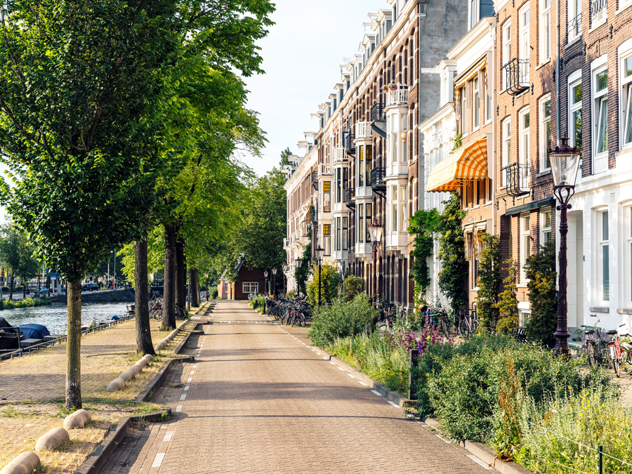
The Case of Amsterdam
Credit: George Pachantouris/ Moment via Getty Images
Tourism to the Dutch city of Amsterdam has been rising at a steady clip. In 2023, more than 20 million people visited this city of around 920,000 people. And it’s not difficult to see why — as one of the world’s best-planned cities, Amsterdam charms with its many canals, world-class museums, pretty architecture, and famous nightlife.
For years, Amsterdam’s city council has tried different measures to minimize the negative impacts of overtourism. The “City Centre Approach” manifesto sums up their intention: to protect the character of the Dutch capital, welcoming those visitors who respect its inhabitants while discouraging those whose behavior doesn’t correspond with these values.
The current tourism policy outlines a number of initiatives, including taking action to minimize disturbances caused by rowdy bachelor parties and organized pub crawls, as well as implementing earlier closing times for bars and clubs where residents may be experiencing disruption. There are also attempts to redress the city’s image as one where “anything goes,” by introducing bans on smoking cannabis on the street and strict criteria for those wishing to lead tours through the infamous red-light district. The city is even considering spreading tourist attractions and facilities throughout the city rather than concentrating them in a relatively small inner-city area.
Meeting Stringent Targets Will Be a Challenge
Credit: ElOjoTorpe/ Moment via Getty Images
The most recent initiative from Amsterdam’s policymakers is perhaps the boldest one yet. Keen to ensure a better standard of living for residents, the city council has made the difficult decision to limit the number of new hotels in the city.
The latest ruling is one of a slew of measures aimed at capping tourist numbers in this popular destination, along with restricting the number of cruise ships allowed on the city’s waterways.The goal is to not exceed 20 million hotel nights for tourists per year. In 2023, the figure stood at 20.67 million, not including holiday rentals, bed-and-breakfast accommodations, and overnight stays from cruise passengers.
While the goal is a lofty one, some progress has already been made. Since 2017, only three planning applications for new hotels have been approved. However, it’s common for planning permission to be granted long before a hotel opens, and there are currently 26 hotels in the pipeline, all in possession of the required permits.
And even as the regulations are tightened up, there are still exemptions for new hotels planning to occupy sites that have previously held the same function, so long as they can demonstrate they meet certain sustainability standards. Unfortunately, rectifying the situation isn’t simply a case of saying “no more.”
Housing Problems for Local Governments
Credit: Alexander Spatari/ Moment via Getty Images
An important factor that has exacerbated Amsterdam’s overtourism situation is the demand for short-term rentals of entire apartments and houses, which can be lucrative for property owners. In turn, this has had a knock-on effect on the availability of housing stock in the city and has increased the cost of longer-term rentals for residents.
As space is at a premium, the availability of housing stock dwindles, particularly as new builds can’t keep pace with demand. In short, vacation rentals are pricing some locals out of the city they live and work in. Commuting longer distances comes with environmental implications, as well, which is why the city council has decided action is needed.
The Problem Isn’t Confined to Amsterdam
Credit: RPBMedia/ iStock via Getty Images
Amsterdam is far from alone in dealing with a record influx of visitors. Some popular places, such as Machu Picchu in Peru, have instigated a cap on daily numbers and require permits for popular hiking routes such as the Inca Trail. Others have imposed temporary closures to enable fragile environments to recover, including Maya Bay in Thailand andIceland’s Fjaðrárgljúfur Canyon.
Other destinations rely on fees levied for day visitors, like the charge recently introduced in Venice. It’s hoped such fees may discourage casual visitors in this perennially popular Italian city, while also creating a useful revenue stream. In the meantime, consider searching for less-crowded alternatives or even look-alikes to these popular tourist destinations.
Advertisement
More from our network
Daily Passport is part of Inbox Studio, an email-first media company. *Indicates a third-party property.
7 of North America’s Best Historic City Neighborhoods to Visit
By
Daily Passport Team
Read time: 7 minutes
May 22, 2024
Updated: May 23, 2024
7 of North America’s Best Historic City Neighborhoods to Visit
History •May 22, 2024•Updated: May 23, 2024
By Daily Passport Team
Author
Daily Passport Team
Daily Passport writers have been seen in publications such as National Geographic, Food & Wine, CBC, Condé Nast Traveler, and Business Insider. They're passionate about uncovering unique destinations and sharing expert tips with curious travelers.
Around the world, historic neighborhoods offer a fascinating glimpse into centuries of urban life and culture. North America is no exception. From one of the world’s oldest Chinatowns to “America’s First Planned City,” stroll through seven of North America’s best historic city neighborhoods below.
Chinatown – San Francisco, California
Credit: Alexander Spatari/ Moment via Getty Images
There’s no better place in the U.S. to explore modern Chinese culture and Asian American history than in San Francisco’s storied Chinatown. The first Chinese immigrants arrived in San Francisco in 1848, and the many who followed them created a vibrant neighborhood even in the face of discrimination and exclusion. Now one of the city’s top tourist attractions, San Francisco’s Chinatown is one of the largest Chinese enclaves outside of Asia and the oldest Chinese community in North America.
Chinatown is best explored on foot. Begin at the ornately tiled Dragon Gate, at the intersection of Bush Street and Grant Avenue, which is Chinatown’s main drag. Practice tai chi at St. Mary’s Square or watch games of mahjong at Portsmouth Square. Admire the architecture at the Sing Chong Building, constructed in 1907. Get your fortune read at the historic Tin How Temple, then grab a sweet treat at the Golden Gate Fortune Cookie Factory or the Golden Gate Bakery. Finally, explore the fish markets, spice shops, and vegetable stands of Stockton Street, where you’ll find succulent Peking duck at Hing Lung Company and the city’s best dim sum takeaway at Good Mong Kok Bakery — trust us, your taste buds will thank you.
Savannah Historic District – Savannah, Georgia
Credit: Sean Pavone/ iStock via Getty Images
Like San Francisco’s Chinatown, the best way to experience Savannah’s Historic District is on foot. Based on the original plan created in the 1730s by James Oglethorpe, the founder of the British Colony of Georgia, this beautiful, eminently walkable neighborhood is known as “America’s First Planned City.” It encompasses 22 lushly landscaped squares draped in the city’s emblematic Spanish moss trees and criss-crossed by an orderly grid of cobblestone streets lined with impressive architecture — a mix of well-preserved Georgian, Greek Revival, and Gothic styles from the 18th and 19th centuries.
Savannah is the oldest city in Georgia, and its federally designated historic district is one of the largest in the country. Savannah’s commercial center is the riverfront City Market: a collection of boutiques, eateries, and galleries bustling with shoppers and performers. Other highlights include Forsyth Park, a 30-acre span featuring war monuments and a Garden of Fragrance designed for the sight-impaired. History buffs will find plenty here, too — from Green Square, the central hub for the African American community in the 19th century, to the French Gothic Cathedral of St. John the Baptist and a long list of historic (many allegedly haunted) houses open for tours.
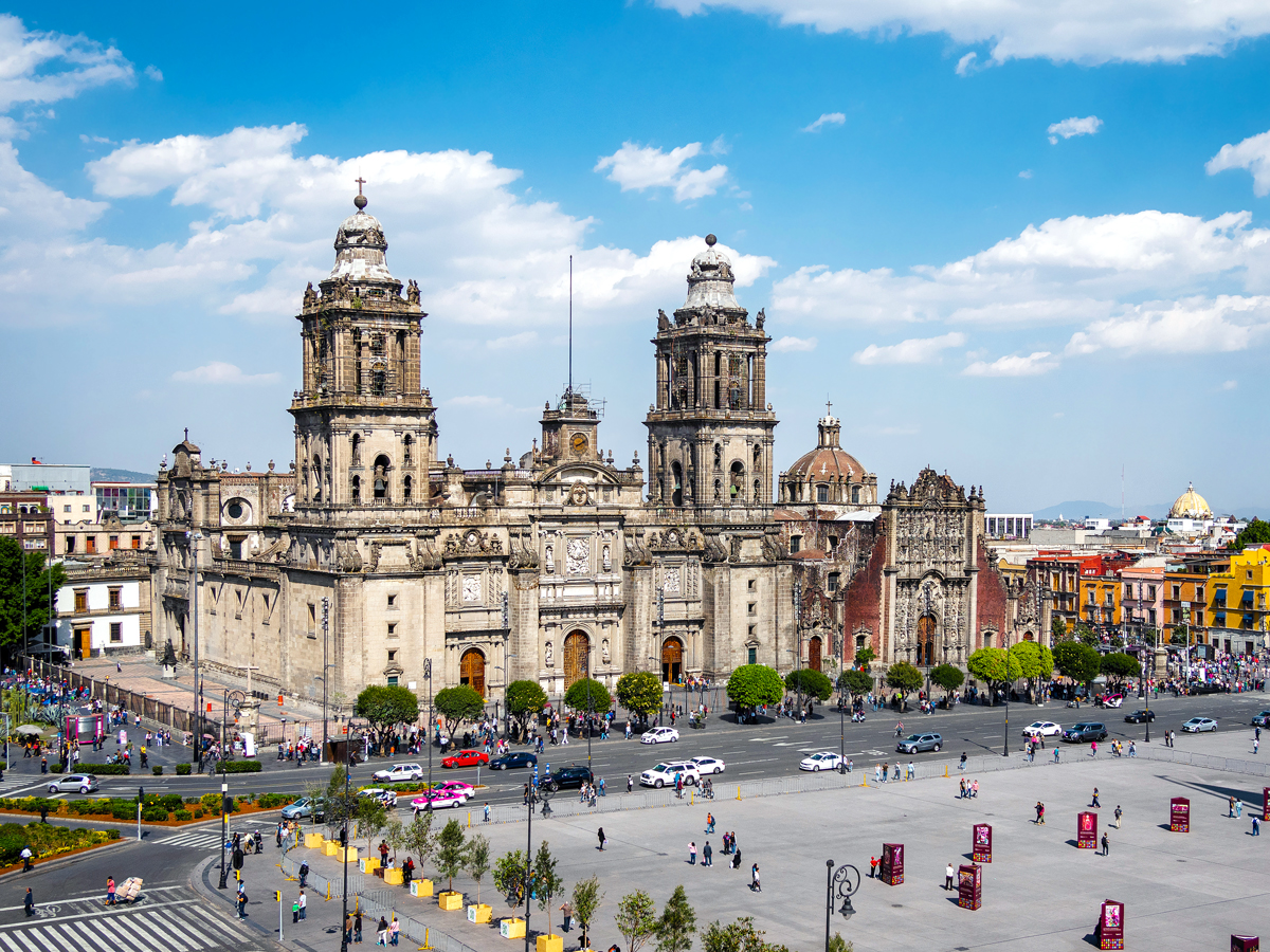
Centro Histórico – Mexico City, Mexico
Credit: R.M. Nunes/ iStock via Getty Images
At the heart of Mexico City’s historic center is El Zócalo, the largest public square in Latin America. El Zócalo was the central ceremonial space for the Aztec city-state of Tenochtitlan, before it was conquered by the Spaniards in 1521. While the square’s formal name is Plaza de la Constitución, many cities in Mexico now refer to their primary squares as zócalos, and Mexico City’s is no exception. The grand square is surrounded by an imposing cathedral, the shops and hotels of the Old Portal de Mercaderes, and the National Palace (formerly the site of Moctezuma’s palace), with its stunning Diego Rivera murals. For some of the best views of the square, grab a drink at the Hotel Majestic.
The plaza can accommodate somewhere in the range of 200,000 people, and it has been the site of many political demonstrations, as well as concerts by artists such as Shakira and Paul McCartney. After a fictional scene in the 2016 James Bond film Spectre that showed a raucous Day of the Dead Parade, the city decided to make the parade a reality, and it’s now an annual occurrence.
Inner Harbour – Victoria, British Columbia
Credit: benedek/ E+ via Getty Images
The capital of Canada’s British Columbia province, Victoria is effortlessly charming — from its British-influenced architecture to the expansive gardens, pedestrian-friendly streets, and seaside setting — and nowhere is that on better display than the photogenic Inner Harbour.
The region was originally home to people of the Songhees and Esquimalt First Nations (whose culture is showcased today through an interpretive walkway along the Inner Harbour), but after the arrival of the Hudson Bay Company in 1843, the area transitioned from a fishing village to a bustling cityscape lined with palatial legislative buildings. It later became an attractive tourist destination, thanks in part to the Inner Harbour Causeway, a walkway originally constructed in 1903 that still houses market stalls and street performers.
One of the star architectural landmarks of the Inner Harbour is the Fairmont Empress Hotel, an Edwardian-style 1908 building that offers both a luxury stay and a spooky adventure for those who believe rumors that it’s haunted. (Even if you’re not staying at the hotel, popping by for afternoon tea is a must.) While the Inner Harbour is pleasant to visit year-round, classical music buffs should consider visiting in the summertime, as the annual Victoria Symphony of Splash features a 56-piece orchestra performing atop a floating stage that culminates with a spectacular fireworks display.
A trip to the Garden District can seem like a balm for visitors to New Orleans: On a streetcar ride east along St. Charles Avenue, the city’s mood changes from the party atmosphere of the French Quarter to something more peaceful and dignified. The streetcars rumble past block after block of Greek Revival mansions fronted by lush gardens and enclosed by elaborate wrought-iron fences. Even the occasional modern structure can’t knock the illusion that you are being ferried back to a different era.
Developed in the 1840s, the neighborhood has managed to retain its sterling reputation, even though you can still find a glimpse of macabre beauty that New Orleans is known for at the area’s Lafayette Cemetery No. 2. (The cemetery’s weathered crypts are located above ground because the city rests below sea level.) In addition to historic residential architecture and spooky graveyards, the Garden District is a thriving neighborhood with notable restaurants along the main streets (among them, Commander’s Palace, established in 1893, is still going strong), as well as a stretch of interesting shops and boutiques on Magazine Street.
Spanish explorer — and Puerto Rico’s first governor — Juan Ponce de León never found the Fountain of Youth that he was searching for in the Americas in the early 16th century, but today you can find his final resting place at the Bautista Cathedral in Viejo (“Old”) San Juan. Built in 1521 at the beginning of Spanish colonization, the original cathedral was destroyed by a hurricane, and the current Gothic-influenced structure was constructed in 1540. The church is only one of many grand and historic monuments on the elegant islet Old San Juan occupies, which is connected to the main island by three bridges.
A free trolley services the most popular spots, but Old San Juan is a city made for strolling. Enjoy the pleasant year-round temperature and refreshing sea breezes while walking cobblestone streets through the seven blocks of this National Historic Site. Don’t miss Castillo San Cristobal, the largest Spanish fort in the New World, and the six-level Castillo San Felipe del Morro (nicknamed “El Morro”) — a fortification built between the 16th and 18th centuries overlooking San Juan Bay, it is perhaps the country’s most beloved landmark.
Standing on the quaint cobbled streets of Montreal’s Vieux Port, it’s easy to picture yourself in New France, the young French colony back when it was inhabited by fur trappers, soldiers, Jesuit priests — all elbowing to gain control of the wild and vast Canadian continent. In fact, by the time settlers landed here in 1642 and claimed the territory for the French king, the St. Lawrence River waterfront in the Vieux-Port (“old port”) section of Montreal had already been used as a camp by French fur traders for several decades.
But as modern times barreled into Montreal, the significance of this beautiful neighborhood was overshadowed by logistical limitations. Transporting cargo unloaded from container ships to railways and trucks proved difficult and costly, so in 1976, the port was shifted a few miles downriver. Fortunately, officials later recognized that the historic quarter was ripe for tourism, and in 1992, the government revitalized Vieux-Port as a heritage destination — with programmed festivals and events and attractions that include a skating rink, an immense Ferris wheel, and plenty of green space. Now, more than 6 million visitors a year come to shop, eat, celebrate New Year’s Eve, attend concerts, and walk in the footsteps of those early settlers.
Advertisement
More from our network
Daily Passport is part of Inbox Studio, an email-first media company. *Indicates a third-party property.
Peter is a Toronto-based journalist, editor, content strategist, and self-professed avgeek with 15 years of experience covering all things travel. Prior to joining Daily Passport, he oversaw newsletter publication for Travelzoo. His favorite destinations to explore include Japan, France, Chile, New Zealand, and his adopted home country of Canada.
Despite the fact that traveling by airplane is the safest mode of transportation out there, some travelers still, understandably, have a fear of flying. If you’re an anxious traveler, you might be curious to know which airlines have the best safety records (or even which section of the airplane could be considered the safest). The annual report from the aviation safety experts at AirlineRatings.com ranks global airlines on criteria such as fleet age, serious incidents, pilot training, and turbulence prevention. Here are the safest full-service airlines to fly in 2026, according to the study.
The flag carrier of South Korea ranks as the world’s 10th-safest airline in 2026. From its main hub at Seoul’s Incheon International Airport, Korean Air serves more than 100 destinations across the globe, including 11 U.S. cities. The carrier is currently renewing its fleet with modern, state-of-the-art aircraft such as the Airbus A350 and Boeing 787. It’s also in the process of merging with rival Asiana Airlines; the latter airline is expected to be fully absorbed under Korean Air by the end of 2026.
You’ll have to head Down Under to find the next airline on the world’s safest airlines list. Established in 2000, Virgin Australia operates a fleet of more than 100 Boeing 737s across Australia, New Zealand, and Southeast Asia, from its hubs in Brisbane, Melbourne, and Sydney.
Taiwan-based EVA Air is the eighth-safest airline in the world as of 2026. Since its founding in 1989, the airline has suffered no major accidents or passenger fatalities. The airline recently announced its 10th nonstop destination in North America; flights from Taipei to and from Washington, D.C., kick off this June.
Singapore Airlines was named the overall No. 2 best airline in the world for 2025 in the Skytrax World Airline Awards, and the carrier also boasts a stellar safety record. Passengers flying on Singapore Airlines have the chance to visit the world’s best airport, Singapore Changi Airport, which has amenities you don’t normally find in an airport, such as the world’s highest indoor waterfall, a butterfly garden, a canopy park, and more.
Air New Zealand dropped to No. 6 from the top spot in the safest airlines ranking last year, but that doesn’t reflect any recent lapses in safety. Rather, as AirlineRatings.com CEO Sharon Petersen explained in a press release, “What stands out this year is how little separates the leaders. Less than four points covered positions one through 14, and at the very top, the margins were even tighter, with just 1.3 points separating positions one through six in the full-service category.”
Dubai-based Emirates operates the world’s largest fleet of Airbus A380 jumbo jets, which is the world’s largest passenger aircraft and has never experienced a major crash since entering service in 2007. Emirates has a large connecting hub in Dubai, which you can explore on a free stopover.
Qatar Airways flies to over a dozen U.S. cities, including Atlanta, Boston, and San Francisco, from its Middle East hub in Doha. The airport ranks as the No. 2 best airport in the world, according to Skytrax; it’s home to amenities like an massive indoor tropical garden called the Orchard and some of the world’s swankiest airline lounges.
Qantas is not only one of the world’s safest airlines but also one of the oldest, having first flown in 1920. To the U.S., the Australian flag carrier operates long-haul flights to Dallas/Fort Worth, Los Angeles, and San Francisco. It also offers one-stop service to New York via Auckland, which takes 17 hours and 30 minutes and ranks as one of the world’s longest flights. The airline could soon take the crown for the single longest flight, as it aims to connect Australia and New York nonstop with new ultra-long-haul planes by 2027.
Cathay Pacific Airways, the flag carrier of Hong Kong, ranks as the world’s second-safest airline for 2026. The airline operates nonstop flights to six U.S. cities, including Los Angeles and New York, aboard a fleet of modern Airbus A350 and Boeing 777 aircraft. In 2026, the airline is celebrating its 80th anniversary since its first flight in 1946.
Another Middle East carrier lands on top of the list of the world’s safest airlines: Etihad Airways, which hasn’t had a single major incident since starting flights in 2003. The airline is based at Abu Dhabi’s stunning Zayed International Airport, offering connections from Europe and North America to destinations throughout the Middle East, India, and Asia.
About the data: To compile this list, we referenced the “World’s Safest Airline Rankings for 2026” from airline safety and product rating website AirlineRatings.com. The report analyzed 320 airlines worldwide on criteria such as incident rates adjusted for the total number of flights, fleet age, serious incidents, pilot training, turbulence prevention, and international safety audits. The airlines above fall in the “full service” category, but the report also listed low-cost airlines separately. You can view the full study here.
Advertisement
More from our network
Daily Passport is part of Inbox Studio, an email-first media company. *Indicates a third-party property.
Fiona has spent her career exploring the world and working in the travel industry, turning her lifelong passion into a profession. From planning custom trips to sharing stories as a travel writer for publications such as The Discoverer, she’s all about helping others experience the world in a deeper, more meaningful way.
Given their location, lakeside towns are naturally peaceful and scenic, and it’s no surprise that they often double as popular vacation spots. Indeed, with their recreational activities, thriving artisan communities, access to wildlife, and overall tranquil vibes, it’s difficult to find the negative side of a lakeside retreat. Nonetheless, certain lake towns stand out from the pack. Here are 12 of the most beautiful lake towns in the U.S. to visit this summer.
Tucked into the Blue Ridge Mountains of western North Carolina, Lake Lure is a tiny lakeside town with just over 1,400 residents. The town is best known as a filming location of the 1987 movie Dirty Dancing; many scenes were filmed around the lakefront cottages of Firefly Cove. Aside from its appeal for film buffs, the town provides easy access to the beautiful Blue Ridge Mountains, where you can enjoy boating and kayaking on the lake or hiking in nearby Chimney Rock State Park.
One of Lake Lure’s most distinctive features is the Lake Lure Flowering Bridge, a former highway bridge that has been transformed into a pedestrian garden filled with flowers, landscaped pathways, and art installations. Lake Lure also has a human-made sandy beach right on the lakefront, which is popular in summertime.
Saugatuck, Michigan
Credit: William Reagan/ iStock via Getty Images
Michigan lays claim to four of the five Great Lakes — Erie, Superior, Huron, and Michigan — plus around 11,000 other lakes. All that to say, if it’s a pretty lake town you seek, the Mitten State won’t let you down. Part of Michigan’s “Art Coast,” Saugatuck is an especially quaint lake town that earned Midwest Living’s Best Beach Town award in 2021.
Saugatuck brims with beauty both natural and human-made, from the strip of art galleries and restaurants in old Victorian buildings that line the town’s historic main drag to the golden sandy shores of Oval Beach on Lake Michigan. Away from the water, Saugatuck offers a host of nature activities in Saugatuck Dunes State Park, such as swimming, wildlife viewing, and miles of pretty hiking trails that traverse the coastal dunes and adjacent forest.
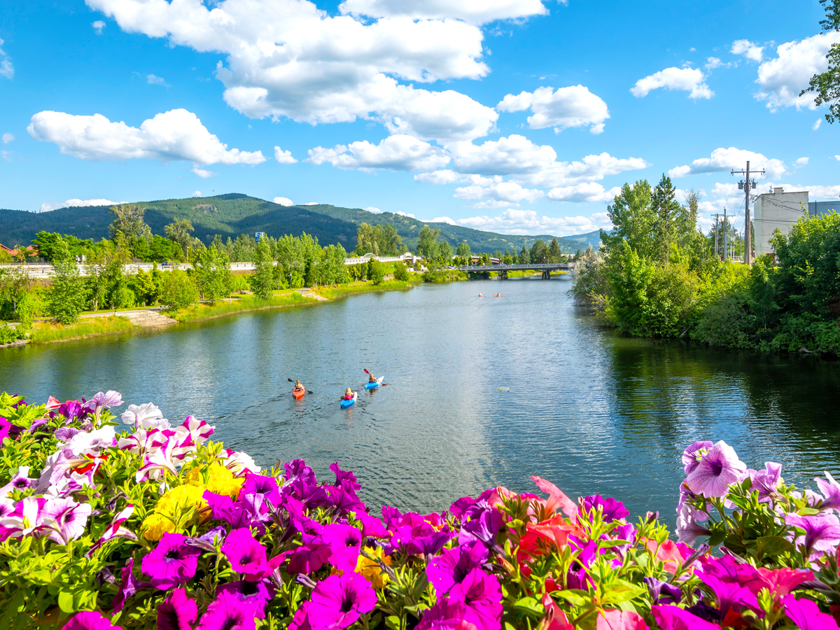
Sandpoint is a laid-back town set along the shores of northern Idaho’s Lake Pend Oreille, one of the deepest lakes in the country. Surrounded by mountains and forests, Sandpoint has an outdoorsy feel and a walkable downtown with local bookstores, breweries, and art galleries.
In summer, many visitors come for boating, paddleboarding, swimming, hiking, and biking, while winter brings skiing and snowboarding at nearby Schweitzer Mountain Resort. For a small town, Sandpoint has a surprisingly strong arts and music scene, with well-known festivals like the Festival at Sandpoint drawing visitors each summer for outdoor concerts by the lake.
The natural beauty of New England is no secret, and the small town of Wolfeboro showcases it spectacularly. Wolfeboro claims the crown of the “Oldest Summer Resort Town in America,” with a history dating to when the colonial governor of New Hampshire built his summer home on Lake Wentworth in 1763. A testament to Wolfeboro’s timeless appeal is the annual seasonal population increase — from around 6,500 permanent residents to a whopping 25,000 in the summer.
On the opposite side of town is Lake Winnipesaukee, the biggest lake in New Hampshire. Visitors flock to this 72-square-mile body of water to swim off one of the many beaches, boat to one of the hundreds of islands, explore craggy coves, or embark on one of the many epic hikes in the foothills of the famous White Mountains that encompass the lake.
The smallest city in Wisconsin happens to sit on the banks of the world’s largest freshwater lake by area. Bayfield — a town of fewer than 600 people — borders Lake Superior, which spans an incredible 31,700 square miles. Bayfield’s charm comes from its colorful harborfront, historic inns, sailboats bobbing in the marina, and relaxed atmosphere surrounded by nature and water.
Kayaking along the shoreline, boating trips to the nearby Apostle Islands, hiking, and spending time in the town’s cafes and local art galleries are among the most popular activities in and around town. The area is also known for its apple and berry orchards scattered throughout the countryside. Fall is an especially popular time to visit, as people come for apple picking, fresh cider, and beautiful views of the foliage.
Rangeley, Maine
Credit: DenisTangneyJr/ iStock via Getty Images
Located roughly 2.5 hours north of Portland, Rangeley is a backwoods country town flush with the rugged beauty Maine is known for. Rangeley’s 55 square miles are sparsely populated with around 1,200 residents, but the town’s location on its namesake lake has been drawing visitors to western Maine for decades. Rangeley Lake is a popular fishing hub for trout and salmon in the summer and a base for many avid skiers and snowboarders seeking fresh powder at Saddleback Mountain in the winter.
If you’re not into casting a line or extreme downhill sports, there’s still plenty to pique your interest. Waterfalls beckon to be discovered, and kayak, canoe, and boat rentals are available to explore the lake. Meanwhile, wildlife such as loons and bald eagles abound, and the hiking is some of the best Maine has to offer.
Lake Placid is a small village in the Adirondack Mountains of upstate New York. Set between lakes and forested peaks, it offers stunning mountain views and serene surroundings. Contrary to what the name suggests, the town of Lake Placid actually sits beside Mirror Lake, with Placid (the lake) located to the north.
Despite its small population of around 2,300 people, the town has a big reputation as a former two-time Winter Olympics host city, and today it still draws visitors for skiing and snowboarding in winter. Summertime pursuits are just as worthwhile, including hiking, biking, and kayaking. Afterward, explore the charming Main Street lined with cozy coffee shops, a variety of restaurants, and artisan shops selling locally made jewelry, decor, and handmade gifts.
Lakeway, Texas
Credit: RoschetzkyIstockPhoto/ iStock via Getty Images
A welcome retreat for Austinites during the hot summer months, Lakeway is located 40 minutes northwest of the capital on the shores of Lake Travis. Lakeway was once a sleepy town that attracted retirees and second-home owners, but the lake’s golden sands, warm waters, and verdant surroundings have caught the attention of many more tourists in recent years. Boat tours, party coves, and plenty of amenities encircle the lake, but if you’re seeking peace and quiet, Lakeway offers cottage rentals, access to Lake Travis parks, and a welcoming, laid-back atmosphere.
Located on the picturesque shores of northwest Montana’s Whitefish Lake, Whitefish is a short drive from Glacier National Park. The town is known for its stunning alpine scenery, quaint downtown, and laid-back vibes. During winter, visitors come to enjoy skiing and snowboarding at Whitefish Mountain Resort; in warmer months, people enjoy hiking, boating, fishing, and paddleboarding. Whitefish’s walkable downtown is filled with cafes, boutiques, breweries, art galleries, and restaurants — plus, the town regularly offers events like Restaurant Week, Gallery Nights Art Walks, and live music at local venues through the summer.
Breaux Bridge, Louisiana
Credit: wanderluster/ iStock via Getty Images
If you’re looking for an introduction to Cajun country, look no further than Breaux Bridge. Located 5 miles from Lake Martin, the town of approximately 7,500 is known as the “Crawfish Capital of the World.” Breaux Bridge claims to have invented the crawfish etouffee and continues to host an annual crawfish festival. Needless to say, sampling crawfish while in town is a must.
Breaux Bridge is also a great jumping-off point to explore the surrounding bayou landscape. Swamp tours on Lake Martin and Atchafalaya Basin offer excellent opportunities for spotting wildlife including heron, barred owls, turtles, osprey, and alligators. Meanwhile, you can admire the majestic cypress trees with moss-draped branches that grow straight out of the lake floor. In addition to water activities, nearby hiking and walking trails — such as the Lake Martin Loop Trail and the Cypress Island Nature Trail — are tranquil alternatives to soak up the beauty of the bayou.
Kimberling City is a quiet lakeside town in the Ozark Mountains set right along the shores of Table Rock Lake. Most of the activity here revolves around the lake, with boating, fishing, and swimming among the biggest draws. Visitors can even take a scenic tour of the lake aboard an authentic paddlewheel cruiser departing from a nearby marina. A few miles south, you can explore Dogwood Canyon Nature Park on guided adventures by Jeep, horseback, bike, or foot.
Eureka Springs, a small town of around 2,200 people, may seem like a blip on the map, but it has long attracted droves of visitors in the summer months. Eureka Springs is nestled in the Ozark Mountains and located within a few miles of Beaver Lake and Lake Leatherwood. Both of these lakes offer visitors cottage or campsite rentals and a plethora of recreational activities such as kayaking, fishing, and hiking.
However, the main draw here is the access to multiple natural mineral springs that encircle Eureka Springs and were discovered in the 19th century. Within walking distance of the town center, you’ll find bathhouses and spas supplied with the natural spring water, but the most popular is Palace Hotel and Bath House, the only one of the town’s former historic bathhouses still in use today. Whether you choose to spend time on the lake or in the healing mineral waters, a visit to Eureka Springs is a sure bet for a memorable summer getaway.
Advertisement
More from our network
Daily Passport is part of Inbox Studio, an email-first media company. *Indicates a third-party property.
7 Enchanting Islands That You Can Walk to at Low Tide
By
Bradley O'Neill
Read time: 6 minutes
May 20, 2024
Updated: May 21, 2024
7 Enchanting Islands That You Can Walk to at Low Tide
Outdoors •May 20, 2024•Updated: May 21, 2024
By Bradley O'Neill
By definition, an island is a body of land that’s entirely surrounded by water. Islands are typically accessible by aircraft or boat, but around the world there are some islands that are technically only islands at high tide. When the water levels are low, they become connected to the mainland by sandbars, natural pathways, or causeways. So, lace up your favorite walking shoes, wait for low tide, and walk to these seven fascinating islands. (Just don’t get stuck when the water starts to roll in again.)
Mont-Saint-Michel – France
Credit: Manfred Gottschalk/ Stone via Getty Images
Mont-Saint-Michel rises like a floating Disney castle out of a bay shared by the French regions of Normandy and Brittany. This UNESCO World Heritage Site first caught the eye of pilgrims in the eighth century, when St. Aubert was divinely guided to build a hilltop church. The Duchy of Normandy and French royals later funded the construction of the island’s spectacular Benedictine abbey.
Cars can drive continuously over a causeway, but the more adventurous way to arrive is to walk across the bay at low tide. Setting foot on the island is akin to stepping back in time to a medieval village. Visitors can stroll the zigzagging alleyways to discover taverns, restaurants, and gift shops — or even stay overnight at one of the island’s handful of hotels and guesthouses.
Bar Island – Maine
Credit: WoodysPhotos/ iStock via Getty Images
Located off the coast of charming Bar Harbor, Bar Island is part of Acadia National Park, the first national park established east of the Mississippi River in 1919. Twice a day, a short strip of sand, rocks, and pebbles called Land Bridge provides access to the island, which was once inhabited by farmers before it became part of the national park.
The best time to avoid getting your feet wet is about an hour and a half before or after low tide. Several plant and animal species, including starfish, appear in natural tide pools on the bridge. On the island itself, the Bar Island Trail is a 1.9-mile out-and-back route that traverses through serene forest and wildflower meadows. Keep an eye out for the remains of old buildings and enjoy views back toward Bar Harbor and over Frenchman Bay. It’s a nine-hour wait between tides, so pay attention to the time to avoid getting stranded.
Brough of Birsay – Scotland
Credit: rpeters86/ iStock via Getty Images
Part of Scotland’s remote Orkney Islands, Brough of Birsay was home to Pictish and Norse settlements from around 600 to 1200 CE. A causeway provides access to this picturesque island from the village of Birsay and the chance to explore the 10th-century ruins of a Norse hamlet.
A replica of a carved stone on the island shows four Pictish symbols, including a crescent and an eagle. (The original is located at the National Museum of Scotland.) Also of interest are the remains of the Romanesque-style St. Peter’s Chapel, which dates to the 12th century. A whitewashed lighthouse stands solemnly on one side of the island, and all around are views of deep blue Atlantic waters and craggy cliffs, where guillemots, puffins, and razorbills nest.
According to legend, after the Muslim saint Pir Haji Ali Shah Bukhari died on a pilgrimage to Mecca, his casket floated back to a rocky islet on Mumbai’s western shoreline. To honor this miraculous event, a mosque and a dargah (tomb) were erected in the 15th century and named Haji Ali Dargah.
Today’s structure mostly dates to the 19th century, and for much of the day it’s a glistening, fairy-tale-like scene of brilliant white domes and minarets. As the water recedes, worshippers form an orderly line across a stone causeway to pay their respects to the revered merchant and spiritual teacher. It’s worth the walk to admire intricate mirror work and mosaic decorations, in addition to the saint’s opulent marble-enclosed floating tomb.
Holy Island of Lindisfarne – England
Credit: Steve Allen/ Stockbyte via Getty Images
The Holy Island of Lindisfarne sits on the faraway and windswept coast of Northumberland, in northeastern England. It was here in 635 CE that St. Aidan arrived from Iona and established a monastery, which later became home to the admired saints Cuthbert and Oswald, before vikings plundered the island in the eighth century.
At low tide, the 3-mile-long Pilgrims Way reveals itself to create a scenic walk to the island. Visitors can stroll in the footsteps of monks at Lindisfarne Priory and explore the Tudor-era Lindisfarne Castle. A community of fewer than 200 people lives here permanently, and you can experience village life at the island’s cafés, pubs, specialty shops, and guesthouses. Holy Island is the last stop on St. Cuthbert’s Way, a 62-mile walking trail that begins in the Scottish town of Melrose.
Fascinating First Nations heritage, historic buildings, and epic hiking trails await on the 500-acre Ministers Island in Canada’s eastern New Brunswick province. This unique island is linked to the mainland by an ocean-floor gravel passage rather than a sandbar or human-made causeway. This allows for both pedestrian and vehicle access from the town of St. Andrews. First inhabited by the Passamaquoddy peoples, the island later became the summer home of Canadian railroad pioneer Sir William Van Horne from 1890 through the mid-20th century.
Now a designated National Historic Site of Canada, the island welcomes visitors to explore the 50-room Van Horne mansion, a bathhouse, a former creamery, and other preserved buildings. A 12-mile network of hiking and biking trails cuts through dense forest and along picturesque shorelines. Late April to May and August to mid-October are great times to spot birds on their spring and fall migrations.
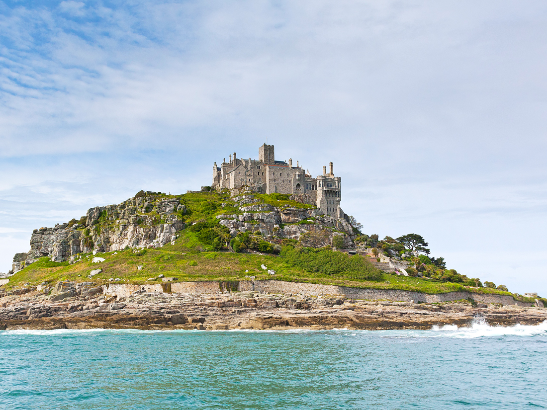
An emblematic image of the Cornish coastline, St. Michael’s Mount is steeped in history and mythology. Since the fifth century, legends have been told of a mermaid on the island guiding seafarers to safe passage. Another island tale tells of Jack the Giant Killer defeating the beast Cormoran. In the 12th century, Benedictine monks — the same ones who worked at the sister abbey on Mont-Saint-Michel — began construction of the island’s church and abbey.
These days, a castle occupies the summit of St. Michael’s Mount and is the home of the St. Aubyn family. Below it, cafés and shops in old stone buildings overlook the harbor. To access the island, a cobblestone causeway crosses Mount’s Bay to the town of Marazion. Walking is the only way to get here in winter, but a ferry service operates during the summer months.
Advertisement
More from our network
Daily Passport is part of Inbox Studio, an email-first media company. *Indicates a third-party property.
Daily Passport writers have been seen in publications such as National Geographic, Food & Wine, CBC, Condé Nast Traveler, and Business Insider. They're passionate about uncovering unique destinations and sharing expert tips with curious travelers.
If you’re looking to admire beautiful architecture, visiting a palace is tough to beat. Breathtaking for their opulence and scale, palaces were built for monarchs, emperors, and other powerful rulers over many centuries. In many cases, they have retained their former grandeur to the delight of today’s tourists. From Spain to Seoul and India to Istanbul, here are seven of the most striking palaces you can visit around the world.
The Palace of Versailles was the famed residence of French rulers, perhaps none more infamous than Louis XVI and Marie Antoinette. Versailles began life in 1623 as a modest hunting lodge, on a site chosen situated to take advantage of the boars and stags who roamed the surrounding woods. However, “modest” is not a word that would be applied to the Versailles you can visit now. The sprawling property stuns with precisely ordered formal gardens, woodland parks, Marie Antoinette’s former estate (Le Petit Trianon), and the grand palace itself.
While Versailles has been operated as a museum since 1833, the palace is no longer deserted after hours. In 2021, a five-star hotel opened in a historic building on the grounds, where mere mortals — for the princely sum of around $2,000 USD per night — can spend the night at Versailles. The 13 guest rooms come with perks for the royally curious: Guests are shown parts of the palace not seen by the touring public. After closing time and in the early morning before the gates open, interested hotel guests are ushered on intimate tours of the grand halls and royal chambers, and may freely wander the gorgeous, 2,000-acre Orangery Gardens.
Jal Mahal – India
Credit: Mirko Kuzmanovic/ iStock via Getty Images
In northwest India, land of the Maharajas (“great rulers”), the Rajput dynasties constructed a series of fairyland forts, palaces, and opulent structures beginning around the 16th century. In Jaipur, their capital city known as “the Pink City” for the rose-hued terracotta paint that predominates, you’ll find the spectacular Jal Mahal (“Water Palace”). Originally built in 1699, it may have served as a lodge for royals hunting the abundant waterfowl that made Man Sagar Lake their home.
While today the palace’s ornate carvings reflect gracefully back in the waters of Man Sagar, the lake at the time of construction was little more than a damp depression — with water accumulating only after days of heavy rains. The four lowest floors of the Jal Mahal are now underwater, after a later king decided to construct dams in the 18th century. Unfortunately, the government closed the mysterious palace and the waters it floats to visitors, but tourists can stroll the edge of the lake and enjoy the architectural grandeur from afar.
Starting with Mehmed the Conqueror in 1478 and for nearly four centuries thereafter, dozens of Ottoman sultans reigned from this sprawling stronghold — with anywhere between 1,000 to 4,000 fellow palace inhabitants at a time. The ornate grounds grew and evolved as they passed from one ruler to the next, so one of the most intriguing elements of any visit to the modern-day museum is the array of esthetics on display, from Islamic to Ottoman to European.
But arguably the most intriguing element of all — perhaps because it used to be forbidden to everyone but a select group — is the harem. A world unto itself, this private residential section of the palace boasts two mosques, nine baths, and a hospital — altogether, there are more than 300 rooms. Among the most notable are the peach-colonnaded Court of the Concubines, the heavily gilded Imperial Hall, the airily white Baths of the Sultan and the Queen Mother, and — the pièce de resistance — the Privy Chamber of Murad III.
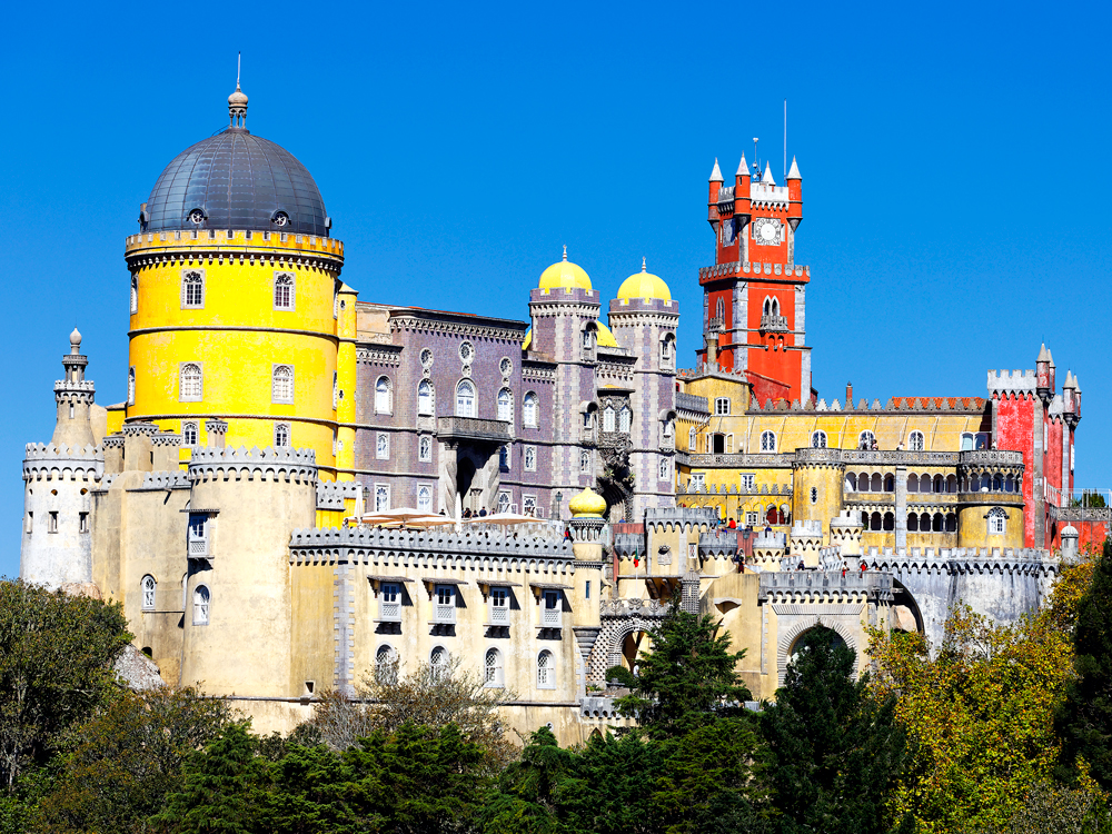
Pena Palace – Sintra, Portugal
Credit: vwalakte/ iStock via Getty Images
An hour outside Lisbon, the Cultural Landscape of Sintra, a UNESCO World Heritage Site, comprises a number of colorful castles and palaces, but Pena Palace is the best known. Instantly recognizable by its bright red and yellow towers overseeing the surrounding area and out to the sea, the palace is a popular cover photo for many guidebooks.
Construction began in the Middle Ages, and a report that the Virgin Mary had appeared on the hill prompted the addition of a chapel. King Ferdinand purchased the monastery and surrounding holdings, and the castle as it appears today was completed in 1854. It’s a fantasy of graceful arches, intricate marble carvings, and dazzling tile mosaics, combining architectural elements from many styles. Don’t miss a walk around the walls to admire the lush gardens.
When the world’s biggest pop group, BTS, kicked off a Tonight Showtakeover in front of a dazzlingly illuminated Korean palace last year, the landmark no doubt shot to the top of millions of bucket lists. But while the gorgeous visuals from that BTS performance alone might make the average fan want to see Gyeongbokgung Palace in person, the sheer age of the site seals the deal for history buffs.
Built in 1395 as the grandest of the Joseon Dynasty’s five Seoul strongholds, the palace has gone through various cycles of destruction, abandonment, and rebirth. It now blends the few original elements with lovingly reconstructed ones to stunning effect. Beyond wandering the mountain-backed grounds, you’ll want to visit the two onsite museums, the National Palace Museum of Korea and the National Folk Museum of Korea, both of which offer a fascinating insight into Korean history and culture.
Alhambra – Granada, Spain
Credit: Luis Dafos/ Moment via Getty Images
A unique fusion of Muslim and European influences, this 13th-century palace has gone through several iterations over the centuries. La Alhambra was first built by a Moorish king; the Moors were a North African Muslim group who inhabited various parts of Spain for about 800 years. The royal residence and fortress overlook the valley below, making it the ideal place for a military leader to reside.
The architecture of the Alhambra is extremely ornate, and the builders made it their goal to have every surface covered in detail. Muslim tradition doesn’t allow for artistic representations of people, so there are poems artistically inscribed on columns and arches, as well as stylized flora. The tile mosaics are another impressive highlight of the Alhambra, showcasing bright colors and stunning patterns. Under the Catholic monarchs, Charles V demolished part of the fortress to build his own palace, called Charles the V Palace. These connecting palaces mean visitors can see a variety of architectural styles and influences all in one place.
Potala Palace – Tibet
Credit: Bim/ E+ via Getty Images
Making its way up Marpo Ri Hill in Lhasa, Tibet’s Potala Palace is all but guaranteed to take your breath away from miles around. Potala Palace, which served as the winter palace for the Dalai Lama until 1959, is the main symbol of Tibetan Buddhism. When visiting the site, you’ll notice both the White and the Red Palaces. The Red Palace is the later addition, built on top of the White Palace. An impressive Buddhist monastery already existed at this location when construction of the palace began in the seventh century.
Given that this palace has stood on this hill for more than a millennium, it certainly deserves its spot as a UNESCO World Heritage Site. Now that the Dalai Lama no longer resides here, the palace acts as a museum. People come from far and wide to see the site, but preservation is of concern. The ancient materials, and even the restored sections, can’t handle the amount of foot traffic that tourism and religious pilgrims could bring. To counteract this, China enacted a visitor quota to protect the palace. The quota has changed over the years as modernization has provided the area with even more access.
Advertisement
More from our network
Daily Passport is part of Inbox Studio, an email-first media company. *Indicates a third-party property.
7 of the Most Charming Towns Near U.S. National Parks
By
Daily Passport Team
Read time: 6 minutes
May 20, 2024
Updated: July 22, 2025
7 of the Most Charming Towns Near U.S. National Parks
Outdoors •May 20, 2024•Updated: July 22, 2025
By Daily Passport Team
Author
Daily Passport Team
Daily Passport writers have been seen in publications such as National Geographic, Food & Wine, CBC, Condé Nast Traveler, and Business Insider. They're passionate about uncovering unique destinations and sharing expert tips with curious travelers.
Travelers from all over the world come to America’s national parks for their breathtaking natural landscapes. But once you’ve hiked through forests, scaled mountains, or spent time stargazing, you need a place to rest and recharge. Fortunately, the towns located near these parks are more than up to the task. Here are seven of the most charming towns near U.S. national parks that make the perfect home base for a nature getaway.
Gatlinburg, Tennessee – Great Smoky Mountains National Park
Credit: Dan Reynolds Photography/ Moment via Getty Images
Great Smoky Mountains National Park attracts more visitors than any other national park in the U.S., but the nearby town of Gatlinburg, Tennessee is a delightful destination in its own right. Offering far more than just souvenir shops, Gatlinburg is home to a vibrant folk art scene, including numerous art galleries and creative workshops, a slew of southern barbecue restaurants and pancake houses, and a scenic chairlift that takes riders to a 1,800-foot overlook of the mountains.
Gatlinburg even has its own 400-foot-tall version of Seattle’s Space Needle, where visitors can soak in 360-degree views of the Great Smoky Mountains and the city — no hiking necessary. The area also boasts the only ski resort in the state, as well as countless hikes to the mesmerizing Laurel Falls and Rainbow Falls, Ramsey Cascades, and the historic ghost town of Elkmont. The abandoned former logging camp is now considered one of the hidden gems of the Smokies.
Flagstaff, Arizona – Grand Canyon National Park
Credit: frankix/ iStock via Getty Images
Several appealing towns skirt Grand Canyon National Park, but none brim with more character than Flagstaff. With an attractive historic downtown, a plethora of quirky shops and museums, and hotels housed in converted turn-of-the-century buildings, the city — which dates back to 1881 — is not to be missed.
Located just over 70 miles away from the canyon’s South Rim, Flagstaff is chock-full of craft breweries and restaurants dishing a rangy of tasty, creative cuisines — perfect for capping off a long day hiking the canyon. And few places on Earth offer clearer stargazing than the Lowell Observatory. At night, enjoy fantastic views of the starry sky, or visit during the day to explore hands-on science exhibits and walking tours.
Bar Harbor, Maine – Acadia National Park
Credit: Peter Unger/ Stone via Getty Images
Bar Harbor is a quintessential seaside town often obscured by a salty mist sweeping only lighthouses into view. Quaint, historic wood cottages dot the town’s rolling green lawns, while seafood restaurant tables scatter out onto the docks along the narrow streets in warm weather. On the menu, you’ll find an abundance of fresh, local seafood prepared in every fashion, from buttery lobster rolls to crisp, crab cakes, spicy bisques, creamy chowders, and raw oysters plucked right from the sand skirting the coast.
Set on Mount Desert Island, adjacent to Acadia National Park, Bar Harbor offers spectacular scenery at every turn. Along the town’s beloved Shore Path, a splattering of tide pools promise hours of outdoor fun for families and nature lovers. There are also views of distant, pine-scented islands — and one is even accessible by foot via a sandbar at low tide. (Just remember to watch the time and tide when planning your return to town.)
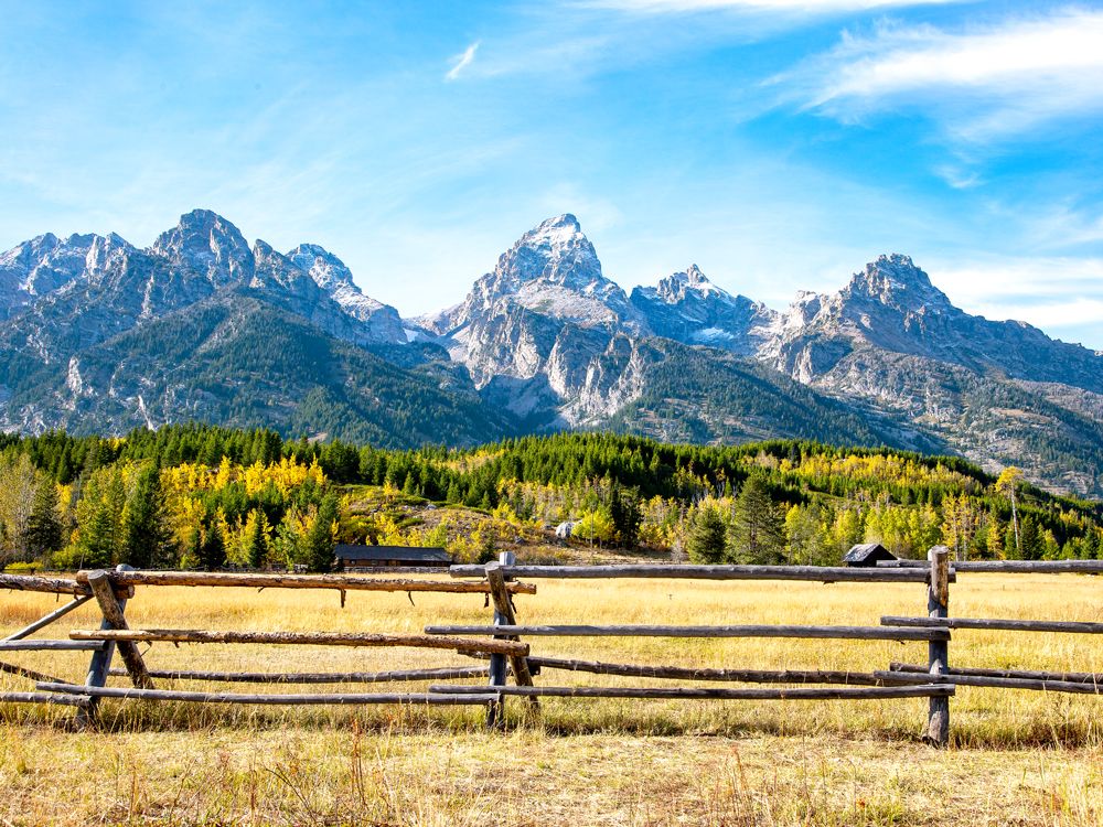
Jackson, Wyoming – Grand Teton National Park
Credit: Jennifer_Sharp/ E+ via Getty Images
At the rim of Grand Teton National Park (and not far from Yellowstone), the small town of Jackson has long been known for its historic hotels, classic steakhouses, cowboys bars, and independent boutiques. Hand-constructed log cabins nestled between aspens and evergreens and elk-antler arches greet visitors at each corner of the old Town Square.
After you’re done exploring the national park, Jackson offers several opportunities for soaking in local culture — including the nearby National Museum of Wildlife Art, the Historical Society and Museum, and the Jackson Center for the Arts. Rodeos are another popular attraction in the area. Beyond world-class skiing available in the Tetons, Jackson abounds with hiking paths that meander up the wooded slopes around Ski Lake and over rushing streams. Rafting on Snake River is also a treat for thrill-seekers visiting in warmer months.
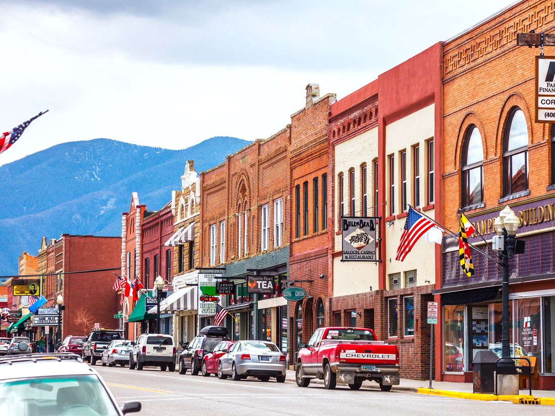
Red Lodge, Montana – Yellowstone National Park
Credit: peeterv/ iStock via Getty Images
Another noteworthy gateway town to Yellowstone National Park is the former mining settlement of Red Lodge. The town was once frequented by the likes of Wild Bill Hickok and Calamity Jane, and it still has a whole lot of Wild West charm leftover. Meanwhile, a growing number of upscale cafés and steakhouses keep the active community and tourists well-fed. And with arts and crafts shops, climbing and fishing gear stores, bookstores, and more, Red Lodge is the perfect place to take it easy before venturing into the great outdoors.
The local Carbon County Historical Society and Museum displays impressive rodeo collections, offers ecology and geology tours of the historic Beartooth area, and contains a fascinating interactive coal mine exhibit. Nostalgic wagon and sleigh rides pulled by draft horses are also available in town. Red Lodge serves up its own slew of exciting outdoor attractions, too. From fly fishing and kayaking adventures to white-water rafting, skiing, horseback riding, and mountain biking along Wild Bill Lake, this town offers something for everyone year-round.
Visalia, California – Sequoia National Park
Credit: DenisTangneyJr/ iStock via Getty Images
Northern California’s Sequoia National Park protects some of the largest living organisms on the planet — namely, the park’s impossibly tall, 3,000-year-old evergreen trees. Nearby Visalia, which is roughly 40 minutes away, is the park’s main gateway town. Visalia offers its own array of wonders, with the Sierra Nevadas right at its doorstep. From white-water rafting to hiking and biking, the great outdoors provide countless opportunities for white-knuckled or relaxed fun around here.
Visalia makes good use of its location in the heart of the country’s most fertile agricultural zone, with locally grown produce featured on the tasty menus of the town’s many farm-to-table restaurants. But history and culture flourish here, too. Much of it can be taken in from a scenic trolley ride through the downtown district, which stops at historic California mission buildings, the Fox Theater (where music performances and classic-film showings are held), and several of the city’s colorful art galleries.
Palm Desert, California – Joshua Tree National Park
Credit: Ron and Patty Thomas/ iStock via Getty Images
Among California’s most popular destinations, Joshua Tree National Park is remarkable for its miles of interesting-shaped cacti, mountains of boulders that are perfect for amateur climbers, and lush palm forests. But the Coachella Valley east of the park shelters its own enticing oasis in the middle of this desert landscape. Palm Springs, known as a midcentury modern design mecca, is a hub of culture and attractions. There’s a wide array of shopping and dining options here, along with a notable art scene, popular music festivals, and rolling green golf courses.
The city retains its Old Hollywood glamor, which is still evident on a tour of the Movie Colony. It once served as a welcome escape for the rich and famous, who were looking for a remote haven far from the drama of Los Angeles. Meanwhile, nearby Mount San Jacinto features the Cactus to Clouds trail, regarded as one of the state’s toughest hiking trails. There are also many easier hikes that skirt the town, such as the trail to Palm Canyon and the picturesque Painted Canyon. The nearby Salton Sea is another notable natural wonder not to be missed.
Peter is a Toronto-based journalist, editor, content strategist, and self-professed avgeek with 15 years of experience covering all things travel. Prior to joining Daily Passport, he oversaw newsletter publication for Travelzoo. His favorite destinations to explore include Japan, France, Chile, New Zealand, and his adopted home country of Canada.
The late 1950s marked the beginning of what many consider the “golden age” of air travel. It was the dawn of the jet era, and as passenger jets took to the skies for the first time, they cut the time it took to fly from New York to London in half. A lot has changed since then. Many of the changes are for the better, particularly the heightened safety standards and greater affordability, yet many travelers find themselves nostalgic for a seemingly more glamorous era in the skies — one without the long security lines, cramped seats, and sneaky extra fees. But was flying back then all it was cracked up to be? Go back in time to discover five things we used to see on airplanes that we no longer do.
Gourmet Meals Plated Next to Your Seat
Credit: Chalabala/ iStock via Getty Images
Before the Airline Deregulation Act of 1978, the federal government set airfares and decided which airlines were allowed to fly which routes in the United States. Since airlines couldn’t compete on price, they competed for customers in other ways, most notably with onboard service and amenities. Back then, it was typical to find free-flowing Champagne served in real glassware alongside multicourse gourmet meals — think lobster, caviar, prime rib carved tableside and served on fine china. Airlines such as Pan Am even went so far as to convert the entire upper deck of their Boeing 747s into a “restaurant in the skies” for first-class passengers.
Flight Attendant Fashion Shows
Credit: andresr/ E+ via Getty Images
Airlines also distinguished themselves when it came to onboard style. Uniforms for flight attendants, who were overwhelmingly female, became a marketing tool used to appeal to male travelers. In 1964, advertising executive Mary Wells Lawrence worked on a rebranding campaign for Braniff International Airways, dubbed the “End of the Plain Plane.” Other airlines, following Braniff’s approach, began introducing uniforms with pops of colors and bold prints by fashion designers such as Emilio Pucci and Jean Lewis. And it wasn’t just the flight attendants who dressed to impress: Passengers during this era dressed to the nines, as flying was still a rarefied experience.
In those days, smoking was the norm in society, and it was no different in the sky. While smoking was discouraged when the plane was on the ground (for fear of igniting fuel fumes), passengers were free to smoke cigarettes, pipes, and cigars while in the air. In 1973, the federal government mandated smoking and nonsmoking sections on airplanes, but as one might imagine, smoke easily traveled from one section to the other. While some airlines introduced their own nonsmoking policies earlier, it wasn’t until 2000 that the U.S. federal government finally banned smoking on all international and domestic flights.
Ample Room to Spread Out
Credit: Chalabala/ iStock via Getty Images
Today, the average legroom in economy class is around 30 to 31 inches on U.S. airlines, but in the 1960s and 1970s, legroom in economy class was similar to what you might find in business class today. Plus, first-class passengers could make use of decadent onboard lounges — and even piano bars — to socialize and pass the time. (That was perhaps a welcome feature before the advent of in-flight movies and smartphones.) Today, you’ll still find a few such spaces on airplanes, but they’re a rarity — reserved only for the top-paying customers on a handful of airlines such as Emirates and Virgin Atlantic.
Higher Airfares (and Longer Travel Times)
Credit: izusek/ E+ via Getty Images
Flying in the mid-20th century may have been more glamorous, but it certainly didn’t come cheap. According to a study by Compass Lexecon, in 1941 the average airfare from Los Angeles to Boston was over $4,500 in today’s dollars, compared to $480 for the same route in 2015. Not only that, but the average travel time was more than 15 hours, including 12 stops along the way.
After the Airline Deregulation Act, new low-cost carriers such as Southwest Airlines exploded in popularity in the U.S., and the increased competition drove down airfares. In the “golden age” of air travel, flying was an experience available only to the exclusive few with means to afford it, but since then it has become much more accessible. At the dawn of the jet age, some 57 million passengers took to the skies, but that number rose to a whopping 4.5 billion in 2019. Plus, thanks to advancements in aircraft technology, planes can now fly much faster and farther, opening up hundreds of new route pairings that simply weren’t possible before.
Advertisement
More from our network
Daily Passport is part of Inbox Studio, an email-first media company. *Indicates a third-party property.
Marissa is a cheap airfare aficionado who loves exploring offbeat destinations with her husband. Based in Los Angeles and Joshua Tree, Marissa has been featured in publications such as San Diego Magazine, Palm Springs Life Magazine, 303 Magazine, and Mountain Living.
If you’ve never been on a cruise, chances are you might feel a little intimidated. But you certainly won’t be alone: 31.7 million travelers set sail in 2023, a number that is projected to grow to 39.4 million by 2027. Seasoned cruisers and cruise experts in the industry know about certain hacks to make sure they’re prepared before they embark, and we’ve compiled 10 helpful tips about what not to do before and after you board. Whether you’re headed to Alaska or the Caribbean, stick to these pro tips for first-time cruisers.
Stay in the Know on Social Media
Credit: urbazon/ E+ via Getty Images
Following your cruise line or connecting with other seasoned cruisers on social media is the first step to ensuring your vacation runs smoothly. Many cruise lines — such as Carnival, Royal Caribbean, and Holland America — have apps that you can download and use to make reservations for shore activities and onboard dining. Plus, they often don’t require Wi-Fi to use. It’s an easy way to see a personalized calendar of what you have booked and the ship’s arrival and departure times. On other social media platforms such as Facebook, you can also connect with fellow cruisers to chat about plans or concerns in private groups.
Consider BYOB
Credit: ViewApart/ iStock via Getty Images
Although many cruises offer drinks packages that can end up saving you money, purchasing a la carte cocktails aboard the ship is a quick way to burn through your wallet. But here’s something that many first-time passengers don’t realize: Oftentimes, you actually bring your own beverages onboard (within a specified limit). Companies such as Disney Cruise Line and Royal Caribbean have a bottle allowance for passengers 21 and older. Check with your line before you depart to see if you can pop your own Champagne on your first night.
Pack a Lanyard and These Other Essentials
Credit: doble-d/ iStock via Getty Images
You probably won’t forget to pack your bathing suit or sunglasses, but there are certain items you may not think to bring on your first cruise. These include a lanyard (for easy key card access), a highlighter (for highlighting which activities you are signed up for), a mesh bag for dirty clothes, plastic file folders for holding important papers, and a small tote or backpack for day trips onshore.
Stay Near Your Departure Dock the Night Before
Credit: martin-dm/ E+ via Getty Images
Missing a cruise does occasionally happen — mostly because of flight delays. To avoid stress at the airport, we recommend arriving at your departure port destination a few days before you’re set to embark, just in case anything happens. The ship won’t turn around for you, so it’s better to be safe than sorry.
Research Port Hub Hot Spots
Credit: NANCY PAUWELS/ iStock via Getty Images
When you arrive at each port on your journey, it’s a good idea to have a general idea of which sights you want to see, where you want to eat, and how much time you have to do these things before the ship leaves. When you dock, many fellow cruisers will be flocking to the same places on foot, so you may find that the nearest restaurants or activities are booked. Before you board, thoroughly research each destination so you can discover hidden gems that won’t be as crowded or touristy. Make reservations and map out your day ahead of schedule.
You Don’t Need to Tip Twice Onboard
Credit: Fuse/ Corbis via Getty Images
Many cruise lines charge a set daily gratuity for stateroom attendants and dining room staff that’s later added to your room bill. Specialty dining, bars, and spas onboard will also often automatically add a tip to the bill, so make sure you read closely and don’t tip more than you intended. When in doubt, ask if gratuity has been included so you don’t pay an additional 18% or 20% more than you need to. Or if you’d prefer simplicity, some cruise lines — such as Silversea and Virgin Voyages — include gratuities in their cruise fares, so there’s no need to tip onboard.
Sign Up for Activities in Advance
Credit: MoMo Productions/ DigitalVision via Getty Images
If your cruise line allows you to do so, sign up for tours, shows, dining reservations, and other activities in advance. These activities fill up quickly, so the early bird will get the worm. If signing up prior to boarding isn’t an option, sign up as soon as you get to your cabin.
Take Advantage of Private Tours
Credit: VeeStudio89/ E+ via Getty Images
Speaking of tours, don’t overlook the ship’s private tour offerings. Each cruise line has a variety of customized tours (for an additional cost) that sometimes only passengers get the privilege of reserving. Many of these excursions — such as hiking to a waterfall or an intimate cooking class — are unique to the area and led by seasoned guides. Tours are also conducted in smaller groups, so you have more time to engage with your guide and will spend less time waiting in lines.
Keep Your Phone in Airplane Mode
Credit: NDStock/ iStock via Getty Images
Even if you’re on vacation, Wi-Fi is a must, especially in the case of an emergency. Unfortunately, most cruise lines still charge for Wi-Fi, so be sure to purchase your cruise line’s Wi-Fi package and keep your phone on airplane mode. Roaming fees (especially abroad) can quickly add up if you don’t have a travel plan. Fortunately, many carriers now offer unlimited talk and text plans that include Canada, Mexico, and the Caribbean, so most cruisers departing the U.S. may not need to worry. But if you’re on your way to Europe or Asia, it’s best to have a plan for your phone use.
Falling ill at sea or experiencing another emergency will be costly if you need to quickly get ashore. One way to be prepared in this case is to purchase travel insurance prior to departure. That way, you can rest easy knowing that if catastrophe calls, you won’t be drowning in debt. (Alternatively, check to see if your credit card offers travel insurance coverage.) Many cruise passengers in March 2020 were happy to have such coverage, and many insurance plans will also include cancellations, flight delays, and other incidents that would prevent you from relaxing on your dream getaway.
Note: All featured products and deals are selected independently and objectively by the author. Daily Passport may receive a share of sales via affiliate links in content.
Advertisement
More from our network
Daily Passport is part of Inbox Studio, an email-first media company. *Indicates a third-party property.